1. Plaquemines
Focus on
Restore • Protect • Preserve
Welcome to the first edition of Focus
on Plaquemines, a monthly update for
coastal restoration and hurricane pro-
tection projects.
As leaders in Plaquemines, we have
stood united in our focus to restore our
coastline and build hurricane protection
for our citizens. We are resilient and
know that Plaquemines is a great place
to live and raise a family.
Because of this, we are investing in
many public projects to improve the
infrastructure and natural habitat of
the Parish. I believe there is solidarity
in seeing construction progress and
benefits realized. This monthly update
will provide a status report on projects
and activities. Facts about projects and
upcoming activities will be highlighted.
This publication will also present details
on specific projects and interviews of
residents impacted by the projects.
We are all in this together and remain
focused on improving Plaquemines
Parish. Let’s move these initiatives for-
ward and monitor our progress. Should
you have suggestions for this monthly
update, let me know.
Thank you,
Billy
MAY 9, 2013 • No. 1
A note from
the president...
Plaquemines Parish President
Billy Nungesser
Plaquemines Parish Government is taking
decisive action to appeal flood insurance policy
changes and minimize the impacts of their
implementation. Additionally, we are moving
ahead with our flood protection initiatives in-
cluding the construction of coastal restoration
projects throughout the parish.
Plaquemines Parish residents living outside
the New Orleans area 100-year flood protection
system – locally referred to as “the wall” – face
new challenges and increased flood insurance
costs due to changes to flood insurance rate
maps and new flood insurance reforms that
will require flood insurance rates to reflect pol-
icyholders’ actual risk of flood damage. These
changes will affect over 10,000 of our residents,
over 8,000 on the West Bank and nearly 2,000
on the East Bank.
Flood Insurance Rate Map updates
On November 9, 2012, FEMA released re-
vised preliminary Digital Flood Insurance Rate
Maps (DFIRMs) for Plaquemines Parish.
The flood risk depicted on the revised
preliminary maps incorporate the New Orleans
area 100-year levee system improvements
in Belle Chasse completed by the U.S. Army
Corps of Engineers and constructed local
drainage system improvements. The updated
information provided through the preliminary
DFIRMs will provide our communities, resi-
dents and business owners more precise infor-
mation about the flood risk we face, allowing
us to make more informed decisions to reduce
our personal risk to life and property.
Our communities can review areas prone
to flooding during the 100-year storm event
– also known as the 1-percent-annual-chance
storm event– by reviewing the preliminary
DFIRMs. With the complex nature of the sys-
tems within Plaquemines Parish, residents and
business owners should look to the DFIRM
maps to understand the possibility of flooding
within their vicinity.
These maps will have major impacts on
our communities where many properties will
be subject to greater flood hazard, additional
compliance requirements, and increased flood
insurance rates. At the recent Community
Plaquemines Parish confronts
flood insurance policy changes
Story continues on Page 2
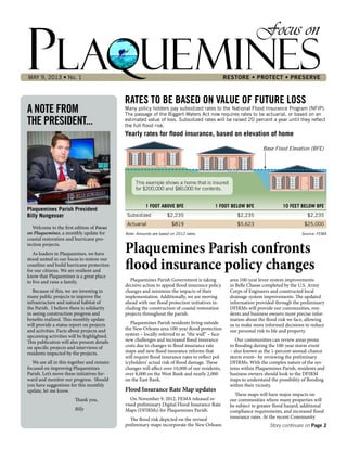
RATES TO BE BASED ON VALUE OF FUTURE LOSS
Many policy holders pay subsidized rates to the National Flood Insurance Program (NFIP).
The passage of the Biggert-Waters Act now requires rates to be actuarial, or based on an
estimated value of loss. Subsidized rates will be raised 20 percent a year until they reflect
the full flood risk.
Yearly rates for flood insurance, based on elevation of home
This example shows a home that is insured
for $200,000 and $80,000 for contents.
Note: Amounts are based on 2012 rates. Source: FEMA
Base Flood Elevation (BFE)
1 FOOT ABOVE BFE 1 FOOT BELOW BFE 10 FEET BELOW BFE
Subsidized $2,235 $2,235 $2,235
Actuarial $819 $5,623 $25,000
2. FOCUS ON PLAQUEMINESPage 2 • May 9, 2013 FOCUS ON PLAQUEMINES
New maps are better at predicting the risk of flooding
Continued from Page 1
Consultation Officer Meetings on March 27th
and April 25th, FEMA representatives present-
ed attendees the proposed map changes. Next
we will be taking part in the Comment and
Appeal process to seek potential changes the
new maps.
Like many other coastal communities, we are
taking action to appeal where feasible, or seek
out alternatives to delay the maps taking effect.
The Biggert-Waters Flood Insurance
Reform Act of 2012 (BW-12)
Plaquemines residents living outside the New
Orleans area 100-year flood protection system
may also face dramatically increased flood in-
surance rates due to the Biggert-Waters Act, the
goal of which is to implement actuarial rates for
the National Flood Insurance Program (NFIP)
to ensure the program’s long-term viability.
Actuarial rates are based on an estimate
of the expected value of future loss. Many
policyholders currently pay subsidized rates
grandfathered in before accurate flood maps
were developed. These rates will be phased in
at 20 percent per year until the full flood risk is
reflected, dramatically increasing some policy-
holders’ flood insurance costs.
Subsidies to be phased out:
• Non-primary residences
• Business properties
• Severe repetitive loss properties (1-4 units),
and properties where claims payments ex-
ceed fair market value
New policies to be issued at full-risk rates:
• After the sale/purchase of a property
• After a lapse in insurance coverage
• After substantial damage/improvement
• For properties uninsured as of BW-12 enact-
ment
• As new or revised Flood Insurance Rate
Maps (FIRMs) are issued (grandfathered
rates planned to be phased out over 5 years)
Minimizing the impacts
To minimize the impacts of FIRM updates
and NFIP rate increases, there are actions that
Plaquemines Parish Government, residents
and business owners can take. Plaquemines
Parish Government is evaluating the option of
appealing the new FIRMs. Dr. Joseph Suhayda,
who is leading the appeal effort said, “we are
going to determine if there are any technical
deficiencies in the maps that would form the
basis for appeal.” The appeal effort would delay
the maps going into effect, giving residents and
business owners some temporary relief. Plaque-
mines Parish could also consider participation
in the NFIP Community Rating System (CRS)
program. The CRS program rewards communi-
ties that implement development and building
codes that go above and beyond the minimum
required to be eligible for flood insurance. Ben-
efits of joining the CRS include reduced flood
insurance rates, enhanced public safety, and
keeping more money in the community instead
of being spent on insurance premiums.
Policy holders can also take certain actions to
minimize the impacts of these changes.
Residents and business owners should talk
with the local officials and insurance agents to
learn about the preliminary flood insurance
rate maps, potential revisions, and possible
changes to their policy. They can also look
into FEMA Mitigation programs available to
them such as the Increased Cost of Compli-
ance (ICC) Program for Residential Properties
which provides up to $30,000 to homeown-
ers for flood proofing, relocation, elevation,
or demolition after a flood. There is also the
FEMA Hazard Mitigation (HMGP) and Severe
Repetitive Loss (SRL) Grant Programs. Prop-
erty owners may be eligible for HMGP or SRL
grants for flood proofing, relocation, elevation,
or demolition.
Finally, policyholders should carefully
consider their options: pay increased rates, go
without flood insurance, elevate their home or
business, or relocate.
Parish Government Taking Action
Currently, Plaquemines Parish Government
is reviewing the preliminary flood insurance
rate maps to determine if technical deficiencies
exist to form the basis for appeal. We will keep
you updated as we seek to minimize the new
flood insurance rate impacts.
In addition, the Parish is moving ahead with
the implementation of its own flood protection
and coastal restoration initiatives including the
permitting and construction of the Reach B-2
(Fort Jackson to Venice) Vegetated Ridge and
Marsh Creation Project as well as other similar
projects throughout the Parish. Plaquemines
Parish Government is also partnering with the
U.S. Army Corps of Engineers to beneficially
use dredged material for the maintenance of
the West Bay land building diversion and the
construction of ridges near Tiger Pass.
Finally, Plaquemines Parish is working with
coastal parishes on the Gulf and East coasts to
advocate for a “national disaster policy” that
addresses the increased costs of the flood insur-
ance policy changes for coastal communities.
Plaquemines Parish President, Billy Nungesser,
said “Failure is not an option. We must work
with all coastal communities to address and
fix this problem.” Plaquemines Parish is taking
these actions to serve and protect our residents
and we will keep you informed as we make
progress on these important initiatives.
Council district Council member Inside Outside TOTAL
1 Percy V. Griffin 1,943 1,943
2 Keith Hinkley 3,703 3,703
3 Kirk Lepine 3,212 3,212
4 Dr. Stuart J. Guey, Jr. 4,909 4,909
5 Anthony Buras 1,040 2,723 3,763
6 Burghart Turner 1,776 1,776
7 Jeff Edgecombe 1,371 1,371
8 Byron Marinovich 1,017 1,017
9 Marla Cooper 1,348 1,348
TOTAL 12,864 10,178 23,042
*Based on 2010 U.S. Census population count
Plaquemines Parish residents that are located inside
and outside the 100-year Flood Protection Levees*
FEMA’s preliminary DFIRMs can be seen at
http://maps.riskmap6.com/LA/Plaquemines/
3. FOCUS ON PLAQUEMINES May 9, 2013 • Page 3FOCUS ON PLAQUEMINES
COASTAL RESTORATION
HURRICANE PROTECTION
Ollie Pump Station to get fronting protection
BP to fund over $200 million of coastal
restoration projects in Plaquemines Parish
A contract to protect the
Ollie Pump Station from the
effects of storm surge was
recently awarded by the U.S.
Army Corps of Engineers.
This project is the first of
seventeen that aims to reduce
the risk of flooding in areas of
Plaquemines Parish that are
located outside the Hurricane
and Storm Damage Risk
Reduction System.
A T-wall will be built in
front of the pump station and
tie into the non-federal levees
on each side. The station’s dis-
charge pipes will be extended
through the floodwall and
upgraded to prevent backflow.
The improved protection will
reduce the effects of storm
surge on the pump station by
preventing water from reach-
ing the pumps and interfering
with their operation.
LA.23
Wilson
Ollie
LA.39
Jesuit
Bend
Ollie
Ollie
Pump
Station
1/20
MILES
Mississippi
River
Project Facts
Type of project: Flood
protection for pump station
Value of project: $11.4 million
Status: Building contract
awarded to Aquaterra-CAYO
with work to last 30 months
Plaquemines Parish President Billy
Nungesser recently announced the
funding of over $200 million in coast-
al projects, which are included in the
Plaquemines Parish Coastal Master
Plan. “Rebuilding our barrier islands
is our first line of defense from major
storms for the communities along the
Gulf coast,” Nungesser stated.
This funding is part of the $1 billion
that BP agreed to invest for early res-
toration of damaged natural resources
resulting from the Deepwater Horizon
oil spill.
The projects in Plaquemines Parish
include:
• Cheniere Ronquille Component,
which is on the west bank of
Plaquemines Parish in Barataria
Bay. This $35 million component
will construct beaches, dunes and
back-barrier marshes.
• Shell Island Component, which is
on the west bank of Plaquemines
Parish in Barataria Bay. This $101
million component will restore
back-barrier marsh and dunes and
beach on the east and west lobes.
• Breton Island Component, which
is on the east bank of Plaquemines
Parish in the Breton Sound. This
$72 million component will restore
and protect beach, marsh and dune
in the Breton Wildlife Refuge and
provide storm protection.
In total, these projects will create
thousands of acres of dune and marsh,
and restore miles of Louisiana’s barrier
island beaches.
BP is also funding $22 million for
the establishment of two Fish Stock
Research and Enhancement Centers,
one of which will be in Point a la
Hache.
SHELL
ISLAND
CHENIERE
RONQUILLE
BRETON
ISLAND
Fish Stock Research and
Enhancement Center
Gulf of Mexico
Breton
Sound
Venice
Buras
Pilottown
Port
Sulphur
Point a la Hache
Belle
Chasse
Mississippi
River
PLAQUEMINES
PARISH
St. Bernard
Parish
4. FOCUS ON PLAQUEMINES
In this first issue of Focus on Plaquemines, we
interview Earl Armstrong. Earl is a cattleman,
a coastal land-building advocate and a life-long
resident of southern Plaquemines Parish.
Where have you lived and worked in
Plaquemines Parish?
I was born in
1944 and grew up in
Pilottown until the
school closed there.
From 8th grade on, I
attended Holy Cross
High School in New
Orleans. After high
school I raised cattle,
trawled, hunted alliga-
tor, anything I could
do to make a living.
As a matter of fact,
I’m going down to pen
some cattle this weekend. I also own a cattle
barge, crew boats and some air boats which I
have used for work in and around the Missis-
sippi River delta since the 1960s, working a lot
with the oil and dredging industries. In 1974
my wife and I moved to Boothville where we
still live. I’ve lived in Plaquemines Parish my
entire life.
What has been your involvement with the
West Bay Diversion project?
I was there when Great Lakes cut it and
watched it run wild for six or seven years. I’ve
worked with Parish officials – Billy Nungesser,
PJ Hahn, and Albertine Kimble – and talked
with the Corps and CWPPRA to recommend
they keep the diversion open and make some
islands down there.
At one point, I took a trip down to West Bay
with Billy Nungesser and U.S. Army Corps of
Engineers’ Colonel Lee to show them how the
diversion was just running into the Gulf and
that islands were needed to slow down the flow
so the silt could drop out and start building
land. About six months later they built a 3,800
square-foot island out there and sand bars
started coming up. They are now building four
more islands. Islands act like backstops, like in
baseball, to slow down the diversion and allow
the sediment to fall out. Otherwise, it would
just scour out the bay and flow out into the
Gulf. Now the material compacts up in the bay
and is beginning to build land.
I grew up in Pilottown and I learned from
the old-timers who grew up there in the late
1800s and early 1900s about how the Missis-
sippi River used to build land before the levees
were built in the 1930s. The delta has steadily
declined since then. There used to be mud
lumps and natural debris like big logs that
would act like backstops to hold the silt from
the river and its tributaries. There’s not as much
flow through the River and the tributaries as
there used to be. Pass a Loutre and South Pass
are mostly blocked and cannot build land any
more.
What is your opinion of the 2012 State Coastal
Master Plan that proposes several diversions?
I think West Bay was cut in the best place
possible. I would agree that it has hurt the
oyster, fishing and trawling down here, but it’s
building the land back. I think diversions need
to be studied and could do well if they are cut
in the right places. I am for diversions if they
build land.
What do you think about Parish plans to build
vegetated ridges outside the back levees?
I agree with any ridge building that helps
provide a buffer from storms. Ridges need trees
to help knock down storm surge. Roseau cane
is a good buffer and grows almost anywhere
except where there is too much brackish water.
When I get caught in squalls I just go up into a
bayou where I am protected by roseau cane.
What is your vision for the future?
Keep pumping material on the banks of
the river and tributaries – it is a quick fix to
rebuild the land. West Bay is doing well and my
children will see the benefits of keeping it open.
The land will probably be built back in 10 or 15
years. I thank Billy, PJ, Albertine and John Snell
from Fox News for putting the word out about
the success of keeping West Bay open.
Earl Armstrong
Armstrong supports West Bay diversion
Page 4 • May 9, 2013
INTERVIEW
Birds flock along Earl Armstrong Island in West Bay. The West Bay project is helping to
rebuild marsh by diverting sediment-carrying water from the Mississippi River.
5. Plaquemines
Focus on
RESTORE • PROTECT • PRESERVE
In 2012, Congress passed the Restore
Act which directs to Gulf Coast States
at least 80% of Clean Water Act fines
levied against BP as a result of the
Deepwater Horizon disaster. The total
penalties to be levied against BP range
between $5 billion and $20 billion.
Thirty-five percent of the fines will
be split equally between the 5 coastal
states (Louisiana, Alabama, Mississippi,
Florida, and Texas). The balance of the
money will be distributed based on a
formula that considers proximity to the
spill and the damage caused. Based on
the proximity of Plaquemines Parish to
the disaster site, we should receive the
largest share of the distribution of these
penalty funds.
In addition to funds that Plaquemines
Parish should receive from the Restore
Act, the parish should receive financial
compensation for the direct impacts
caused by the oil and the resultant clean-
up activities. The activities surrounding
the events of 2010 continue to have
negative impacts on the environment in
our parish.
Both of these initiatives are the focus
of my attention and we will continue to
keep residents updated on our success.
Thank you,
Billy
June 13, 2013 • No. 2
A NOTE FROM
THE PRESIDENT...
Plaquemines Parish President
Billy Nungesser
Recounting the Deepwater Horizon
Oil Spill’s Impact on Plaquemines
In the aftermath of the Deepwater Horizon
explosion, fire and 4.9 million barrel oil spill
– the largest environmental disaster in U.S.
history – oil accumulated on a total of 1,080
miles of Plaquemines Parish’s shoreline.
That is almost one-third of all of the shore-
line impacted by oil in Louisiana. Adverse
impacts to wildlife, fisheries and habitats were
widespread and documented. Fisheries were
repeatedly closed harming the culture and
livelihoods dependent upon them. The local
economy – especially the seafood and tourism
industries – experienced deep declines. BP
and its drilling partners were named responsi-
ble parties in the disaster and will be required
to pay Clean Water Act fines based on the
amount of oil spilled and their liability still yet
to be determined by a federal civil trial.
Based on the latest estimates, Plaquemines
Parish stands to receive between $13 million
and $52 million in RESTORE Act funds de-
pending on the amount of per barrel Clean
Water Act penalties levied against BP and its
drilling partners.
The Civil Trial against BP
The civil trial to determine the liability
of BP and its drilling partners for the spill
began on February 25, nearly three years after
the explosion and collapse of the Deepwater
Horizon rig. The trial will determine the
causes of the spill and assign responsibility to
the parties involved, including BP, contractor
Halliburton, rig operator Transocean, and
Cameron, which manufactured the blowout
preventer meant to stop oil leaks. It will also
determine how much oil was actually leaked,
which will lead to the calculation of how
much BP owes in civil fines, i.e. Clean Water
Act penalties.
The Clean Water Act allows the collection
of $1,100 per barrel of oil spilled, or $4,300 per
barrel if there is a finding of gross negligence,
from any party found responsible for an oil spill
in federal waters. Based on the estimated 4.9
million barrels of oil spilled in the Gulf of Mex-
ico, BP could face fines between $5.4 billion
and $21.1 billion.
The first phase of the sprawling BP Gulf of
Mexico oil spill trial came to a close on April
17th. U.S. District Judge Carl Barbier Jr. heard
eight weeks of testimony about whether BP
or its drilling partners should be held liable
for the spill. Given the case’s complexity, legal
observers say it could be another year before
Barbier issues a ruling on the first phase.
The trial is currently in recess until Sept.
16 when the second phase will begin. It will
focus on two key questions that arose between
the sinking of the Deepwater Horizon rig
and Sept. 19, 2010, the day the runaway well
The RESTORE Act: The largest coastal
restoration investment in U.S. history
Story continues on Page 2
6. FOCUS ON PLAQUEMINES
was sealed: 1) What steps BP, Transocean and
other parties took to stop the spill; and 2) How
much oil was released into the Gulf.
The size of any fine under the Clean Water
Act will be based on the second phase’s
determination of the amount of oil released,
combined with Barbier’s conclusions about
liability and negligence during the first phase.
Barring a settlement, if any issues remain
undecided additional trials could be required,
which could carry the case well into 2014.
2012’s RESTORE the Gulf Coast Act
The Resources and Ecosystems Sustain-
ability, Tourist Opportunity, and Revived
Economies of the Gulf States Act of 2012 – the
RESTORE Act – will invest the Clean Water
Act fines levied against BP and the other
responsible parties.
To address the immense economic and
environmental damage, the legislation will
direct 80 percent of the fines into a trust fund.
It will represent the largest single investment
in environmental restoration in U.S. history.
This RESTORE Act will:
• Dedicate 80 percent of Clean Water Act
penalties for the restoration of the Gulf
Coast environment and economies
Under previous law, Clean Water Act civil
penalties went to the Federal Treasury. The
RESTORE Act directs 80 percent of the pen-
alties resulting from the Deepwater Horizon
oil spill to a Gulf Coast Restoration Trust
Fund (“Trust Fund”) to be spent in the Gulf
Coast where the damage occurred.
• Provide needed resources directly to Gulf
Coast States to start recovery immediately
35 percent of the funds from the Trust
Fund will be allocated directly and equally to
the five Gulf Coast states for ecological and
economic recovery along the coast. Under
this provision, 30 percent of Louisiana’s por-
tion will be allocated directly to its 20 coastal
zone parishes based on a formula.
• Establish a Federal-State Gulf Coast Eco-
system Restoration Council (GCERC)
The Gulf Coast Ecosystem Restoration
Council, established in the RESTORE Act,
will develop and fund a comprehensive plan
for the ecological recovery and resiliency of
the coast. The Council will be comprised of
federal agencies and state representatives.
30 percent of the funds in the Trust Fund
will be allocated to the Federal-State Council
to implement the comprehensive plan.
30 percent of the funds in the Trust Fund
will be allocated to the states based on actual
impact to implement state plans, which must
be approved by the Federal-State Council.
• Research, Science and Technology
2.5 percent of the funds will be allocated
for the establishment of a Gulf Coast fisheries
monitoring program.
The last 2.5 percent of the funds will be
allocated directly and equally to the five Gulf
Coast states for the establishment of a Gulf
Coast Center of Excellence in each state.
The GCERC Council
The Gulf Coast Ecosystem Restoration
Council (GCERC) is the federal-state body
that will oversee the spending of billions of
CWA fines. On May 23rd, GCERC released a
“draft initial comprehensive plan” for spend-
ing the money on projects that will restore the
coast’s natural resources and also benefit the
economy. The draft plan can be found at www.
restorethegulf.gov. The 20-page document was
accompanied by a 112-page environmental
assessment and a list of several hundred po-
tential federal and state projects and programs
that have been authorized but not yet begun.
The RESTORE Act in Louisiana
Coastal Master Plan
The Louisiana legislature unanimously
approved the 2012 Coastal Master Plan on
May 22, 2012. The plan proposes to spend $50
billion over 50 years to restore and protect
Louisiana’s coast. The RESTORE Act will
provide the significant down payment needed
to jumpstart the restoration and protection
projects included in the plan.
At the May meeting of the Coastal Pro-
tection and Restoration Authority, coastal
officials announced a list of 39 proposed resto-
ration projects that they hope will be partially
or fully financed by money the state or federal
agencies expect to receive. Included on the list
are 19 projects in New Orleans area parishes –
the vast majority of which are in Plaquemines
– including nine diversions, six barrier islands,
three projects that will use sediment pipelines
to rebuild wetlands, and the creation of an
oyster reef wave barrier.
Parish Allocations
The funding allocated to Louisiana’s coastal
zone parishes will be based on formula that
considers shoreline miles oiled, population
and land mass. Eligible parishes will have a
comprehensive land use plan in place prior to
receiving funds.
The RESTORE Act in Plaquemines
Based on the allocation formula, Plaque-
mines stands to receive from $13 million to
$52 million in RESTORE Act funds depending
on the amount of per barrel CWA penalties
levied. Plaquemines Parish will soon have
a comprehensive land use plan in place as a
part of its Parish Master Plan, which is in the
documentation and adoption phase. Upon
adoption, the Parish will be eligible to receive
funds.
Page 2 • June 13, 2013 FOCUS ON PLAQUEMINES
RESTORE
Act funds to
be invested
Continued from Page 1
CLEAN WATER ACT PENALTIES
$5 Billion - $21 Billion
LOUISIANA
80% Gulf Coast Restoration
Trust Fund
70% Louisiana Coastal Protection & Restoration Authority (CPRA) 30% 20 Coastal Zone Parishes
15%
PLAQUEMINES
PARISH
85% Other 19 Coastal
Zone Parishes
20% Oil Spill
Liability Trust Fund
35% States’ Equal Share
7%
TX
7%
LA
7%
MS
7%
AL
7%
FL
30% States’
Allocation Formula
30% Gulf Coast
Ecosystem Restoration
Council
5% Gulf Coast
Research, Science,
& Technology
PUBLIC MEETING
What: A engagement session will be
held to give the public the opportunity
to provide input on the Draft Plan and
the Gulf Coast Ecosystem Restoration
Council’s restoration planning efforts.
The 30-day formal public comment
period for the Draft Plan and associated
documents began May 23, and ends
June 24. The Draft Plan can be found
at: www.restorethegulf.gov
When: June 12 at 6:30 p.m., doors
open at 6:00 p.m.
Where: Belle Chasse Auditorium, 8398
Louisiana Hwy. 23, Belle Chasse
7. FOCUS ON PLAQUEMINES June 13, 2013 • Page 3FOCUS ON PLAQUEMINES
SPECIAL UPDATE
FLOOD PROTECTION
Fronting protection being added to Diamond
Plaquemines Parish completes coastal
restoration sustainability study
Construction of a floodwall
to protect the Diamond Pump
Station from surge is underway
and reported to be 19% complete.
The U.S. Army Corps of Engineers
awarded the $8.1 million dollar
contract to Aquaterra-CAYO, a
Texas-based company.
The work consists of construc-
tion of a T-wall and short levee
tie-ins to connect the new fronting
protection to the existing levees.
Two discharge pipes will extend
through the floodwall. The im-
proved protection will reduce the
effects of storm surge on the pump
station by preventing water from
reaching the pumps and interfer-
ing with their operation.
The project duration is 70
months and is part of the Corps
plan for upgrading approximate-
ly 37 miles of back levees and
completing other flood protection
work in Plaquemines Parish.
LA. 23
Diamond
Bohemia
Diamond Rd.
1/20
MILES
Mississippi
River
Diamond
Pump
Station
PROJECT FACTS
Type of project: Flood
protection
Value of project: $8.1 million
Status: Under Construction
Plaquemines Parish Government
was asked by the Coastal Protec-
tion and Restoration Authority of
Louisiana (CPRA) to extend their
implementation planning to address
the issue of sustainability.
The objective of the Plaquemines
Parish Sustainability Study is to
assess the sustainability of coastal
restoration projects in Plaquemines
Parish that have the potential to
provide protection from hurricane
surge and waves and to examine
innovative dredging strategies to re-
alize efficiencies in the development
and implementation of restoration
and protection projects.
The study evaluates the sustain-
ability of storm protection benefits
of various barrier island, marsh
restoration, and forested ridge
projects that have been proposed
for construction. The findings of
the study substantiate Plaquemines
Parish’s position that coastal resto-
ration projects need to be designed,
constructed and evaluated based
on their sustainability, resilience
and ability to provide storm risk
reduction as well as restore coastal
processes and habitat.
The study is considered to be a
first step in evaluating the sustain-
ability of projects from both the
Plaquemines Parish Strategic Imple-
mentation Plan and the 2012 State
Coastal Master Plan. Currently,
the Parish is scheduling a meeting
to present the study to CPRA and
receive their feedback. We will keep
you updated as to the outcome of
this meeting.
8. FOCUS ON PLAQUEMINES
Lower Plaquemines Parish is part of the Mis-
sissippi River Basin which has an average land
loss rate of 1.3 square miles per year. Restoring
the marshes through direct/scatter deposi-
tion of dredged material and the subsequent
reestablishment of emergent wetland vegeta-
tion will help to protect the levee system from
accumulated damage due to elevated water
levels and storm surge forces.
To pursue this effort, the Bureau of Ocean
Energy Management, Regulation and Enforce-
ment (BOEMRE) approved a Coastal Impact
Assistance Program (CIAP) Grant to Plaque-
mines Parish for $1,237,608 for the Fringe
Marsh Repair Planning project. This grant is
for Phase 1 Planning Grant tasks, including
preliminary and final engineering and design,
supervision and inspection, and project ad-
ministration. Evans-Graves Engineers, Inc. was
procured through Plaquemines Parish to be the
engineers for the project.
Project Objective
The objective of this project is to restore
wetland areas along the Fringe Marsh seaward
of the Plaquemines Parish back levee toe by
dredging from borrow areas and disposing
materials into the designated areas. The borrow
ocations are man-made canal bottoms which
require maintenance dredging within direct vi-
cinity of the project sites; thus, beneficial reuse
of sediments is achieved.
The eight areas identified for dredge-and-fill
occur in the following locations, totaling nearly
300 acres of new marsh creation (in bold) and
marsh nourishment:
1. Port Sulphur (south of Martin Lane) 13.27
acres
2. Port Sulphur (north/south of Hi-Ridge Mari-
na) 18.76 acres
3. Port Sulphur (Civic Drive Boat Launch) 6.86
acres
4. Port Sulphur (southeast of Swift Energy
Harbor) 4.91 acres
5. Homeplace (west of Gainard Woods Pump
Station) 21.94 acres
6. Myrtle Grove (Wilkinson Canal) 9.16 acres
7. Pointe a la Hache (southeast of Beshel’s
Marina) 6.64 acres
8. Willis Point (southeast of Belair pump sta-
tion) 20.24 acres
These eight locations are in need of resto-
ration due to the breakup and fragmentation. If
that fragmentation is allowed to continue, the
integrity of the levees, which provide critical
protection for businesses and residents, may be
compromised. Restoring these fringe marshes
will thus provide a buffer for those adjacent
back levee reaches.
Engineering and Construction
The construction phase was funded with
$2.3 million through the CIAP program and
$4.5 million through the U.S. Fish & Wildlife
Service. The project was awarded in July of
2012 to Coastal Dredging Company, Inc. for a
total construction cost of $4.8 million – nearly
$2 million under the project’s budget. It is
currently under construction and approximate-
ly 75 percent complete with only the Wilkinson
Canal and Belair pump station sites remaining.
Work is expected to be completed in
October, which is on-schedule despite the
interruption due to Hurricane Isaac in August/
September of 2012.
PPG receives grants for 300 acres of fringe
marsh restoration planning and construction
Page 4 • June 13, 2013
COASTAL RESTORATION
WILLIS POINT
(Southeast of
Belair Pump
Station)
MYRTLE
GROVE
(Wilkinson
Canal)
POINTE-A-LA-HACHE
(Southeast of Beshel’s Marina)
PORT SULPHUR
(South of Martin Lane)
PORT SULPHUR
(Southeast of Swift Energy Harbor)
PORT SULPHUR
(Civic Drive Boat Launch)
HOMEPLACE
(West of
Gainard Woods
Pump Station)
PORT SULPHUR
(North/South of Hi-Ridge Marina)
MississippiRiver
PLAQUEMINES
PARISH
ST. BERNARD
PARISH
JEFFERSON
PARISH
9. Plaquemines
Focus on
RESTORE • PROTECT • PRESERVE
April 20, 2010 will forever be seared
into the memories of Plaquemines
Parish. With the loss of 11 lives and
the release of nearly 5 million barrels
of oil into the Gulf of Mexico, the
Deepwater Horizon explosion and
spill is one of the largest environmen-
tal disasters in U.S. history. And over
three years later, we are still suffering
from its effects and continue our
response efforts, with tar mats being
discovered as recently as two weeks
ago off Grand Terre.
The Cat Islands are an example of
the devastating and accelerating det-
rimental effects that this spill has had.
What was once thriving habitat that
provided sanctuary and nesting space
for thousands of pelicans, the islands
began being depleted by the com-
bination of subsidence, erosion and
storms. And now because of the spill,
all of the mangroves are dead, and the
islands may soon be completely lost.
The rapid, permanent disappear-
ance of these islands in such a short
time is yet another wake up call that
must be addressed with immediate
action if we are to continue to live and
thrive in our coastal communities.
We must respond.
Thank you,
Billy
July 11, 2013 • No. 3
PRESIDENT’S NOTE
Plaquemines Parish President
Billy Nungesser
The Cat Islands, comprised of Cat Island
East and Cat Island West, in Plaquemines
Parish are a group of bird nesting islands
located behind East Grand Terre Barrier
Island. For hundreds of years, they were
essential habitat nesting grounds for tens of
thousands of shore birds including rare and
endangered species such as brown pelicans,
Rosette spoon bills, and the rare Red Egret.
In 1935 the islands encompassed an area
of 350 acres. By 1998 they had been reduced
to a mere 30 acres, and today they have
withered to less than 1 acre.
Oil Spill Damages
During the Deepwater Horizon oil
spill, approximately 30 percent of the oil
that reached Louisiana’s shoreline passed
into Plaquemines Parish, mostly through
Quatro (Four) Bayou Pass and covered the
islands with thick oil. By all accounts, the
Cat Islands were ground zero to the largest
environmental disaster in the country’s
history.
Three years later, the once heavy popula-
tion of mangrove trees that once inhabited
the islands has died along with the root sys-
tem that helped hold the islands together.
Now the islands are rapidly disappearing.
Nesting Birds
Louisiana only has six (6) bird nesting
islands and they all have one thing in com-
mon - they are all disappearing. Prior to the
oil spill, tens of thousands of birds could be
seen nesting on Cat Island. Unfortunately,
this will be the first year in the history that
the revered pelicans and other birds will not
be able to nest there. Over 75% of all mi-
gratory birds pass through this area which
offers unique nesting grounds and is critical
for their future throughout Louisiana.
The history of the pelican, and its come-
back from endangered status to its removal
from the Endangered Species Act list in
2008, demonstrates the importance of these
Plaquemines offers plan to
reestablish the Cat Islands
Story continues on Page 2
The Cat Islands have traditionally been a Pelican nesting area. In recent years the islands
have faced subsidence, erosion, storms and the Deepwater Horizon oil spill.
10. FOCUS ON PLAQUEMINESPage 2 • July 11, 2013 FOCUS ON PLAQUEMINES
small islands and the critical nesting
grounds they provide. The need to
rebuild these islands is critical.
Outside Support
Since the restoration of the Cat
Islands is not in the 2012 State Coastal
Master Plan, Plaquemines Parish pur-
sued outside support to save them.
National Geographic helped the Par-
ish to photograph their disappearance
from both air and water. The resulting
images were dramatic, showing the
rapid land loss which was occurring
and offering a compelling visual for the
public to understand coastal erosion and
its effects. By traveling through the State
and showing the pictures to the public
and to the media, the Parish has raised
over $3 million towards the rebuilding
effort, with additional monies possibly
available from other agencies.
Project Status
Engineering and design activities are
complete and permits have now been
issued to rebuild two islands. Funding
requests have been made for restoration
of the islands through early Natural
Resource Damage Assessment repara-
tions and from the National Marine Fish
and Wildlife Foundation. Construction
could begin immediately when funding
is obtained.
Plaquemines is also investigating
additional cost saving options such as
combining the restoration of Cat Island
with the restoration of other islands in
the area.
Conclusion
Reestablishing these islands would
once again provide prime nesting
grounds to local and migratory birds,
give storm surge protection to nearby
marsh, and offer economic benefits by
attracting worldwide birders to Plaque-
mines Parish.
Cat Islands
have dwindled
in size over
past 75 years
Continued from Page 1
West Cat Island as seen in November of 2012.
CAT ISLAND WEST:
Proposed island
Existing
island
Vegetation
planting
Beach
Compound
subaqueous
slope
Breakwater
artificial reef
2000
FEET
N
LA. 23
LA. 39
East and West
Cat Islands
50
MILES
Gulf of Mexico
Mississippi
RiverPort Sulphur
Empire
There is a plan to restore both the East and West Cat Islands. The goal is to restore or
create 30 acres at an estimated cost of $11 million. The permits to begin work on both
islands have been issued. Construction funds are being sought. Here is a look at the plan
for the West Cat Island restoration:
WEST CAT ISLAND RESTORATION PROJECT
East Cat Island as seen in November of 2012. In 1935 the island covered 350 acres.
Last year it covered less than an acre.
11. FOCUS ON PLAQUEMINES
LA.23
SCOFIELD ISLAND
RESTORATION AREA
100
MILES
Gulf of Mexico
MississippiRiver
Empire
Buras
Bootheville
Triumph
PLAQUEMINES
PARISH
Dredge
sediment
pipeline
Borrow
area
Borrow area
Borrow
area
EmpireWaterway
LA.23
WALKER ROAD
LA.39
10
MILE
M
ississippi
River
Oakville
Jesuit
Bend
Braithwaite
LaReussite
PLAQUEMINES
PARISH
JEFFERSON
PARISH
OAKVILLE TO
LAREUSSITE
BACK LEVEE
Conoco
Phillips
July 11, 2013 • Page 3FOCUS ON PLAQUEMINES
COASTAL RESTORATION
FLOOD PROTECTION IMPROVEMENTS
Oakville to LaReussite back levee to be raised
Scofield Island’s long-distance sediment
delivery to create barrier island protection
Approximately 8.1 miles of non-federal
levees on the west bank of Plaquemines
Parish will soon be raised to an elevation of
7.5 to 9 feet and incorporate the non-federal
levee into the New Orleans to Venice Federal
system.
The U.S. Army Corps of Engineers recently
awarded the $41.6 million dollar contract to
Target Construction, a Nevada-based com-
pany. The 30-month contract for raising the
existing earthen levees between Oakville and
LaReussite will tie into the Ollie Pump Station
project, which is currently under construc-
tion. Upon completion of both projects, a
continuous line of risk reduction from storm
surge will stretch from Barataria Bay to the
Jesuit Bend community.
Construction of the Oakville to LaReussite
project is the fourth of seventeen New Orle-
ans to Venice non-federal levee projects and
is expected to be complete in late 2015. Target
Construction is soon scheduled to commence
pre-construction activities including photo-
graphing and video documentation.
Construction is currently
underway for the Scofield
Island barrier island resto-
ration and marsh creation
project, one that is critical to
implementing the multiple
lines of defense protection
strategy for Plaquemines
Parish.
Utilizing a borrow source
from the Mississippi River
located near Empire, dredged
sediment is being transport-
ed over 22 miles via pipelines
to build beach and dunes,
thus making it the longest
sediment delivery project
ever performed in Louisiana.
Additional sediment for the
marsh creation area is being
dredged from an offshore
borrow site.
PROJECT
FACTS
Type of project:
Barrier
island/marsh
creation
Acres restored/
created:
238 (beach/
dune) and 398
(marsh)
Value of
project:
$60 million
Status: Under
construction
PROJECT
FACTS
Type of
project:
Levee
raising
Value of
project:
$41.6
million
Status:
Awarded
April 29,
2013 – Pre-
construction
activities
12. FOCUS ON PLAQUEMINES
With the 2013 hurricane season in full swing,
Plaquemines Parish is better prepared than
in previous years; however, the Parish is still
very vulnerable due to weak spots in the levee
systems. Parish Government has been working
diligently to ensure the safety of lives and prop-
erty in Plaquemines Parish.
Office of Homeland Security and
Emergency Preparedness (OEP)
This office provides residents and business-
es with necessary information to plan for an
emergency, disaster of any kind, or to report
suspicious activity. Disasters can be in the form
of weather conditions or man-made, including a
refinery accident or possible terrorist attack.
The OEP encourage residents and businesses
to review the information provided and keep
important numbers and information where it is
accessible should an emergency or disaster oc-
cur or to report suspicious activity. Plaquemines
Parish will use the Plaquemines Parish Govern-
ment website: www.plaqueminesparish.com,
news stations, radio stations and, if necessary,
emergency personnel to inform residents and
businesses when and if it is necessary to take
precautionary measures or should the need to
evacuate arise.
The parish offers guidelines and assistance to
all residents for any emergency. If a resident has
special medical needs, does not have transpor-
tation or is in need of a shelter, the OEP website
contains all the information needed to help
make necessary arrangements for family and
pets. The OEP website can be accessed at:
www.plaqueminesparish.com/emergency-
preparedness.php
Lower Plaquemines Parish
Lower Plaquemines may need to evacuate
in the event of a tropical storm or even severe
rain storm due to the compromised levees and
lack of adequate protection from storm surge.
Residents are strongly encouraged to constantly
monitor the Plaquemines Parish Government
website, news stations and radio stations for the
latest evacuation and other information during
inclement weather situations. Residents should
ensure they have a personal plan and know the
evacuation routes out of the area as well as the
contra-flow and shelter information. Most im-
portantly, contact OEP if you have any questions
or need assistance at (504) 297-5660.
PLAQUEMINES PARISH OFFICE OF
HOMELAND SECURITY AND EMERGENCY
PREPAREDNESS
8056 Highway 23, Suite 308
Belle Chasse, LA 70037
Phone: (504) 274-2477
Fax: (504) 297-5635
E-mail: oep@plaqueminesparish.com
Director
Guy Laigast
Office: (504) 274-2476
Assistant Manager
Patrick Harvey
Office: (504) 297-2477
Administrative Assistant
Barbara Marcotte
Office: (504) 297-2477
SPECIAL NEEDS/PATIENTS WITH MEDICAL
CONDITIONS
Contact the Plaquemines Parish Health
Department at (504) 394-3510 or through
the switchboard at (504) 297-5000.
TRANSPORTATION DURING A MANDATORY
EVACUATION
If you need a ride call: (504) 297-5000
(parish switchboard), or the Sheriff’s De-
partment’s Storm Line: 1 (800) 937-1072.
PET EVACUATIONS DURING AN EMERGENCY
If you have questions or wish to pre-regis-
ter your pet please call the Animal Control
Department at (504) 394-3510.
THE PLAQUEMINES PARISH EMERGENCY
NOTIFICATION SYSTEM
This system allows the parish to notify
residents and business owners in the
event of an emergency by phone, text and
e-mail. Residents and business owners
are encouraged to register for this FREE
service at: alertregistration.com/plaque-
mines/
THE PLAQUEMINES PARISH RE-ENTRY
NETWORK
The re-entry application process allows
business owners to register their business
to apply for re-entry status and receive
placards. Business owners should register
for re-entry as soon as possible to ensure
they have their credentials prior to any
type of emergency requiring an evacu-
ation. Business owners can register at:
placards.plaqueminesparish.com
Be prepared for hurricane season
Page 4 • July 11, 2013
EMERGENCY SUPPLY KIT
• Water for drinking and sanitation
(minimum one gallon per person
per day for at least three days)
• Food (three day supply)
• Battery-powered or hand crank
radio and NOAA Weather Radio
with tone alert
• Extra batteries
• Flashlights
• First Aid Kit with insect repellant
• Whistle or noisemaker to signal
for help
• Dust masks
• Plastic sheeting and duct tape
(for shelter-in-place)
• Wrench or pliers to turn off
utilities
• Can opener
• Local maps
• Refill prescriptions prior to storm
• Eyeglasses
• Pet food and extra water
• Important documents (insurance
papers, ID, bank account info all
in portable, waterproof container
• Cash or traveler’s checks and
change
• Sleeping bag or bedding mate-
rials
• Change of clothing (for several
days for each person)
• Change of shoes
• Chlorine bleach and medicine
dropper (Disinfectant – diluted
nine parts water to one part
bleach; Treat water – 16 drops of
regular household liquid bleach
per gallon of water. Never use
scented, color safe or bleaches
with added cleaners).
• Fire extinguisher
• Matches in waterproof container
• Personal hygiene items
• Mess kits (paper plates, cups
and utensils)
• Paper and pencil
• Books, games and puzzles for
children
13. Plaquemines
Focus on
RESTORE • PROTECT • PRESERVE
With each new day, Plaquemines
Parish Government continues our
mission to make our Parish a safer,
more resilient, and affordable place
to raise our families and grow our
businesses.
Continuing to rebuild and complete
our flood protection system is a top
priority for my administration. The
West Bank and Vicinity-Mississip-
pi River Resilient Features projects
include building stronger, larger
levees and T-walls along the Missis-
sippi River to increase hurricane and
flood control protection against storm
events and riverine flooding.
And while we continue to rebuild
our protection system, we are also
fighting to keep flood insurance
affordable, and to argue that the
federal government should rightfully
recognize those that have always built
by the rules. That’s why I have met
with dozens of elected officials from
across the Nation to build a coalition
to fight against these unreasonable
flood insurance rate hikes – that could
be coming not just to Louisiana but to
coastal and flood plain communities
across the country.
Thank you,
Billy
August 8, 2013 • No. 4
PRESIDENT’S NOTE
Plaquemines Parish President
Billy Nungesser
Work is set to begin on a series of projects
that will add Resilient Features (RF) to the
Mississippi River levees near Belle Chasse.
These features will improve the operation,
maintenance and longevity of this portion
of the levee system by widening the bases of
earthen levees, building concrete floodwalls,
and armoring levees. The WBV-MRL 2.2
project has gone out for bid and the contract
will be awarded this month.
The six Resilient Features projects stretch
from property owned by Tulane Universi-
ty, located just upriver from Belle Chasse
near the Orleans Parish line, to Oakville,
just downriver from Walker Road (see map
above). All the RF levee projects are located
in Plaquemines Parish and construction will
concentrate solely on the west bank of the
river in the West Bank and Vicinity (WBV)
hurricane systems.
Co-Located Levees
The primary function of the levees along
the Mississippi River is to prevent the river
from overflowing its banks during flood
stage or stop what is known as a riverine
event. These levees also are an integral part
of the hurricane and storm surge risk reduc-
Mississippi River levee projects
to reduce the risk of flooding
Story continues on Page 2
PLAQUEMINES
PARISH
ORLEANS
PARISH
JEFFERSON
PARISH
LA.23
Belle Chasse Highway
Walker Road
LA.39
Braithwaite
Gretna
Belle
Chasse
MississippiRiver
10
Miles
LEVEE AND FLOODWALL HEIGHTS TO BE RAISED
A stretch of Mississippi River levees on the west bank in Plaquemines Parish will be
improved to reduce the risks from river flooding and hurricane and tropical storm surges
PROJECTS
WBV-MRL 1.2A:
Oak Point to
Oakville (a)
WBV-MRL 1.2B:
Oak Point to
Oakville (b)
WBV-MRL 2.2:
Oak Point
(Chevron
Oronite)
WBV-MRL 3.2:
Belle Chasse to
Oak Point*
WBV-MRL 4.2:
Oak Road to
Belle Chasse
WBV-MRL 5.2:
Tulane
University
property to Oak
Road
*Includes one 700 foot
section of concrete
floodwall.Source: U.S. Army Corps of Engineers
Earthen
levee
Concrete
floodwall
A
B
C
D
E
F
A
B
C
D
E
F
14. FOCUS ON PLAQUEMINESPage 2 • August 8, 2013 FOCUS ON PLAQUEMINES
tion system for parts of Plaquemines Parish
and the other four New Orleans metropol-
itan area parishes. Because these sections
of the Mississippi River levees serve a dual
purpose, they are designated as Co-Located.
Co-Located Levees are designed to meet
the required levee grade to reduce the risk
from the storm surge that has a one percent
chance of occurring in any given year, a 100-
year event, and is higher than the levee grade
required to reduce risk from a riverine event.
All the RF projects levees are Co-Located.
Engineered Alternative Measures
The Resilient Features projects are the
second phase of the Hurricane and Storm
Damage Risk Reduction System (HSDRRS),
work authorized and funded by Congress for
southeast Louisiana after Hurricane Katrina.
Work on the first phase – the Engineered
Alternative Measures (EAM) – has recent-
ly been completed. The goals of the EAM
construction were to build levees that could
defend against a one percent, or 100-year,
storm surge event and meet the require-
ments for accreditation. The goals of the
second phase are to improve upon the work
completed in the first phase.
Resilient Features Projects
For areas with earthen levees, the RF
projects will shift them, either toward the
protected side or toward the river side, and
enlarge their bases so that the levees have
milder slopes than the previously completed
EAM levees. The EAM levee work was pri-
marily constructed on existing rights-of-way
and yielded levees with steep slopes. For the
RF work, additional rights-of-way may be
acquired when needed to accommodate the
larger levee footprints. All earthen levees will
be armored to protect them from erosion
and scouring.
In areas without earthen levees, the RF
projects will remove top soil and build new
concrete floodwalls. For the floodwall con-
struction, additional rights-of-way may also
be acquired.
All Resilient Features construction will
be performed in ways to minimize potential
impacts on the environment and histori-
cal/cultural resources. Work hours will be
limited to daylight hours except for minor
instances, construction vibration will be
monitored, unpaved roads will be wetted to
minimize dust and attention will be paid to
staging of equipment to minimize noise.
Resilient Features will offer improvements to levees
Continued from Page 1
RIVER FLOODING AND SURGE RISK REDUCTION
The Mississippi River levees in Plaquemines Parish are known as Co-Located Levees.
They serve the dual purpose of reducing the risk of river flooding and storm surge. The
current projects are the second phase of improvements and will raise exisiting levee
heights and broaden their bases. There are three methods employed to do this:
SIDE SHIFT: Levee is built higher, its base is made wider and the crown is shifted.
STRADDLE: The levee’s base is made wider.
FLOODWALL: T-walls are built. LEVEE ARMORING
• Armoring prevents erosion and
scouring on the protected side of
levees and floodwalls.
• All earthen levees will be armored.
• Armoring includes the placement of
grass, articulated concrete blocks
and high-performance turf
reinforcement mats.
Original levee crown is removed
Original
levee
Original
levee
PROTECTED
SIDE
FLOOD
SIDE
New compact
fill is added
New
crown
New compact fill is added
Reinforced
concrete
Source: U.S. Army Corps of Engineers
There are four governmental entities involved in the six Resilient Features projects.
The U.S. Army
Corps of Engineers
is the federal
sponsor. The Fed-
eral Government
will pay for 65%
of the cost.
The Plaquemines
Parish Government
is the local interest
partner. The parish
has been acquiring
easements, both
temporary and per-
petual, on behalf of
CPRA and the West
Bank Levee District.
The West Bank Levee District and the
Plaquemines Parish Government will
maintain and operate the six projects
once completed.
The Coastal Protec-
tion and Restoration
Authority of Louisi-
ana is the non-fed-
eral sponsor. The
state of Louisiana
will pay for 35%.
RESILIENT FEATURES PROJECTS PARTNERS
15. FOCUS ON PLAQUEMINES
Rendering of a pump station
with fronting protection. The
discharge pipes extend through
the T-wall.
August 8, 2013 • Page 3FOCUS ON PLAQUEMINES
COASTAL RESTORATION
FLOODING RISK REDUCTION
Existing Wilkinson Pump Station to be replaced
Plaquemines Parish partners with Corps for
beneficial use of dredged material program
A contract for construction of a new pump sta-
tion near Myrtle Grove has been awarded by the
U.S. Army Corps of Engineers to Phylway Con-
struction of Thibodaux. The 33-month contract
calls for the construction of a new pump station
with a pumping capacity of about 1,000 cubic feet
per second. It will replace the existing Wilkinson
Canal Pump Station.
The pump station will include “fronting protec-
tion features,” which are designed to reduce the
effects of storm surge on the station during tropi-
cal weather. The protection includes construction
of a concrete T-wall in front of the station and an
extension of the pump discharge pipes through
the floodwall. Valves or gates will also be incor-
porated into the discharge pipes to prevent back-
flow. In addition, tie-ins to the existing levees on
both sides of the pump station are planned.
The project, which the Corps expects to com-
plete by the summer of 2016, is part of the New
Orleans to Venice non-federal levee system and
is the fifth contract to be awarded as a part of that
levee project.
A promising option for restoring
coastal wetlands and reducing land loss
is the beneficial use of dredged material
(BUDMAT). The U.S. Army Corps
of Engineers, New Orleans District,
dredges an average of 64 million cubic
yards (mcy) of material annually during
maintenance dredging of navigation
channels throughout Louisiana. Cur-
rently, approximately 24% (15.4 mcy)
of the material is used beneficially.
There is a reasonable potential to use an
additional 20 mcy annually if sufficient
funding is made available.
Plaquemines Parish Government
is executing a design agreement to
become the non-federal sponsor for
the BUDMAT program in partnership
with CEMVN, where the parish would
contribute a 35% cost-share in the plan-
ning, engineering and design of two
projects in the area of the Mississippi
River bird’s foot delta. The projects will
create new habitat and enhanced storm
protection near Venice and the critical
infrastructure at the Port Complex.
Project 1: Planning and design of
ridge features in the Tiger Pass/Grand
Pass area. Disposal area plans, drawings
and specifications will be developed
for two options; one using a cutterhead
pipeline and one using barges to trans-
port the dredged material.
Project 2: Planning and design of
multiple marsh sites and one ridge fea-
ture in the West Bay area. Disposal area
plans, drawings and specifications will
be developed for two options; one using
a cutterhead pipeline and one using a
hopper dredge pumpout method.
Both projects will beneficially utilize
sediments dredged from Southwest
Pass.
PROJECT FACTS
Type of project: Flood protection
for pump station
Value of project:
$29.5 million
Status: Awarded July 13, 2013 to
Phylway Construction
LA.23
10
MILE
MississippiRiver
MainPass
SouthwestPass
TigerPass
West
Bay
Venice
Pilottown
PLAQUEMINES
PARISH
CANDIDATE VEGETATED
RIDGE SITES
CANDIDATE MARSH
CREATION AREAS
PLAQUEMINES
PARISH
SITE OF NEW
WILKINSON
CANAL PUMP
STATION
Existing
pump
station
LA. 23
LA. 39
Ironton
Myrtle
Grove
Phoenix
MyrtleGroveRd.
AudubonDr.
1/20
MILES
Mississippi River
WilkinsonCanal
16. FOCUS ON PLAQUEMINES
July has been a busy month for Plaque-
mines Parish President Billy Nungesser. He
has traveled around the country to meet with
government officials and speak about needed
changes to the Biggert-Waters Flood Insur-
ance Reform Act of 2012. Implementation of
the act would result in massive hikes in flood
insurance rates for many Plaquemines Parish
residents and business-owners as well as for
other coastal communities.
President Nungesser was the key note
speaker at the 2013 Gulf Coast Restoration
Summit at Tulane University. He also just
returned from a national speaking tour.
At the invitation of New York Governor
Andrew Cuomo, he traveled to Albany
to speak at the Building Back Better: NY
Rising Storm Recovery Conference. He
spoke about the importance of changing the
Biggert-Waters Act so that communities like
Plaquemines Parish and those devastated by
Hurricane Sandy can afford to rebuild.
In Fort Worth, Texas, he spoke at the
National Association of Counties’ Annual
Meeting. President Nungesser and several
coastal leaders are working to form a Coastal
Coalition to address new flood insurance
rate mapping challenges.
From Fort Worth he traveled to San
Francisco to speak at the Emerging Issues in
Homeland Security and Disaster Response
Conference. He spoke about federal and
local response efforts made after Hurricanes
Katrina and Isaac and the BP Deepwater
Horizon Oil Spill and its impacts.
“The purpose of this trip was to contin-
ue to educate people on the importance of
changing the Biggert-Waters Act. It is not
acceptable for it to stay as it is. No one living
in these coastal communities can afford to
pay thousands of dollars each and every year
for flood insurance. This is why I believe
it is so important for me and all the other
coastal parish presidents and mayors to
continue our work to bring awareness of the
issues about the National Flood Insurance
Program,” said President Nungesser.
In addition to speaking engagements,
President Nungesser also participates in a
weekly conference call with leaders through-
out Louisiana to discuss how they can
address the Biggert-Waters legislation and
FEMA flood insurance rate maps.
Louisiana’s Congressional
Delegation Takes Action
Congressman Billy Cassidy and Senator
Mary Landrieu have both led efforts that
would prevent or delay the implementation
of the Biggert-Waters Act and also require
FEMA to recognize local investments in
flood protection in the update to the new
flood insurance rate maps.
Congressman Cassidy passed an amend-
ment to the Homeland Security Appropri-
ations bill that blocks increases to grandfa-
thered NFIP rates for existing policy holders
who find themselves below “Base Flood El-
evation” requirements of flood maps issued
after their compliance with previous maps.
Senator Landrieu announced that the
Senate will vote on her legislation to prevent
FEMA from raising rates on “grandfa-
thered” NFIP properties. The legislation
directs FEMA to give communities credit
for non-accredited levees and complete their
affordability study. It includes approximately
$10 million to modernize flood maps and
help ensure they reflect local investments in
flood protection infrastructure.
Nungesser
drives national
conversation on
flood insurance
Page 4 • August 8, 2013
President Billy Nungesser met with New York Governor Andrew Cuomo in Albany, New
York, on July 18. President Nungesser spoke at the Building Back Better: NY Rising
Storm Recovery Conference.
President Billy Nungesser spoke at the Conference on Homeland Security & Disaster
Response in San Francisco on July 23.
17. Plaquemines
Focus on
RESTORE • PROTECT • PRESERVE
Coordination and participation
from all levels of government is
critical to addressing the coastal plight
that Plaquemines Parish is facing. In
this Edition, we provide an update on
the federal government’s Gulf Coast
Ecosystem Restoration Council and
their approval of their comprehensive
plan to restore and protect the coast.
But as noted, many of the concrete
decisions regarding programs and
projects that will help rebuild and
protect Plaquemines Parish are yet
to be made. With your participation,
input, and support, we must ensure
that Plaquemines Parish and our
neighboring Parishes, which received
the brunt of the oil spill’s impacts, get
our fair share.
As a Parish, we are putting our
money where our mouth is, and we
have begun to implement our coastal
bonding initiative that will allow us to
build restoration and protection proj-
ects, such as the Reach B-2 Vegetated
Ridge, that are critical to protecting
our entire Parish. At the one-year
anniversary of Hurricane Isaac, we
recognize the hardships and applaud
the resiliency of our citizens, and
we commit ourselves to protect and
rebuild wiser and stronger.
Thank you,
Billy
September 12, 2013 • No. 5
PRESIDENT’S NOTE
Plaquemines Parish President
Billy Nungesser
In the second edition of Focus on Plaque-
mines, we looked at the RESTORE Act – the
Resources and Ecosystems Sustainability,
Tourist Opportunity, and Revived Econo-
mies of the Gulf States Act of 2012 – which
will invest the Clean Water Act fines levied
against BP and the other responsible parties.
The legislation directs 80 percent of the fines
into the Gulf Coast Ecosystem Trust Fund
(Trust Fund) for restoration of the Gulf
Coast. The RESTORE Act also establishes
the Gulf Coast Ecosystem Restoration Coun-
cil (Council) and mandates the development
of an “initial comprehensive plan” that out-
lines how the funds will be spent to restore
the coast’s natural resources and benefit the
Gulf Coast’s economy.
In this edition, we provide an important
update on the Council’s activity.
On Aug. 28 in New Orleans, the Council
held a public meeting where it voted on and
approved the Initial Comprehensive Plan
(Plan) and discussed anticipated oil spill
restoration projects.
The approved final draft of the Plan has a
three-fold purpose:
• To establish overarching restoration goals
for the Gulf Coast region.
• To describe how the Council will solicit,
evaluate, and fund projects and programs
for ecosystem restoration.
• To describe the process for the approval
of State Expenditure Plans that will fund
projects, and activities that will improve
the Gulf Coast ecosystem and economy.
The development and implementation of
the Plan will evolve over the coming years
into a comprehensive, Gulf-wide, multi-pur-
pose restoration plan based on the best
available science. The Plan does not current-
ly include the “Ten-Year Funding Strategy”
or the “Funded Priorities List” of resto-
ration projects which set forth how funds
are allocated and to which projects. These
items have been deferred by the Council due
to uncertainty around a variety of factors
associated with ongoing litigation and the
RESTORE Act council meets to
approve plan and discuss projects
Story continues on Page 2
Chairwoman Penny Pritzker speaks at the Gulf Coast Ecosystem Restoration Council
(GCERC) public meeting in New Orleans on Aug. 28. GCERC voted to approve the Initial
Comprehensive Plan outlining BP oil spill fine allocations and restoration goals.
18. FOCUS ON PLAQUEMINESPage 2 • September 9, 2013 FOCUS ON PLAQUEMINES
ultimate amount and timing of administra-
tive and civil penalties that may be available
to the Trust Fund.
On September 6th, the U.S. Department of
Treasury released the regulations that govern
how the Trust Fund will be allocated. The
proposed rule details how affected states and
parishes can request grants for economic
and environmental restoration projects. The
Treasury will receive public comments on
the regulation for 60 days and will publish
the final procedures soon thereafter. This is
an important step forward in finalizing the
processes and requirements to allow the flow
of fines to agencies and governments respon-
sible for implementation.
The proposed regulations are available
at http://www.scribd.com/doc/165845969/
Treasury-RESTORE-Act-Trust-Fund-
Proposed-Rule. Comments may be
submitted electronically through the
Federal eRulemaking Portal at
http://www.regulations.gov or by mail to
Department of the Treasury, Attention Janet
Vail, Room 2050; 1500 Pennsylvania Avenue,
NW; Washington, DC 20220.
Why the Plan is Important for
Plaquemines Parish
The Plan’s critical value to Plaquemines
Parish is that it outlines how the Parish may
offer ideas and proposals for ecosystem
restoration projects and programs. The Plan
is also significant because it will eventually
include a “Funded Priorities List” which will
determine the projects to be constructed in
the Parish.
One of the plan’s seven objectives is to
“promote community resilience.” This seeks
to bolster the sustainability of coastal com-
munities through the re-establishment of
natural buffers against storms and flooding,
also a key objective for Plaquemines as
demonstrated by the Reach B-2 Vegetated
Ridge Project featured in this issue.
These types of projects and programs
would include “natural resource planning
and natural resource recovery planning with
locally driven solutions” (emphasis added).
The Plan goes on to state that “projects and
programs that promote community resil-
ience should be tied to ecosystem restoration
or protection.”
The Plan affirms that the Council will
provide opportunities for the public to offer
ecosystem restoration ideas through its
website and public meetings. Currently, this
is the only opportunity for Plaquemines to
submit ideas as most funding, planning and
implementation will flow through the Coun-
cil and the State. However, as the Parish’s
objectives clearly align with the Council’s,
the Parish will be proactive in engaging
the Council and advocating projects and
programs its officials, residents and business
owners support.
Oil Spill Restoration Projects in
Plaquemines Parish
In addition to the RESTORE Act man-
dates, other oil spill restoration planning
processes are ongoing, including the Natural
Resources Damage Assessment (NRDA)
and those sponsored by the National Fish
and Wildlife Foundation (NFWF).
The NRDA process is led by federal and
state resource agencies and involves the
evaluation of damage to natural resources,
the development of recovery and restoration
plans for damaged resources, and the imple-
mentation of restoration projects including
such activities as replanting wetlands and
restoring damaged fisheries.
Currently the NRDA team is in the
process of implementing Early Restoration
Projects and developing and Final Resto-
ration Plan. Early Restoration projects in
Plaquemines Parish include the restoration
of barrier islands – Breton Island, Shell
Island West and Chenier Ronquille – and the
Lake Hermitage marsh creation project.
NFWF has received $1.275 billion from
the criminal settlement with BP and from
Transocean for the purpose of barrier island
restoration and the planning and con-
struction of Mississippi River diversions in
Louisiana.
The Coastal Protection and Restoration
Agency (CPRA) is the state agency that
represents the state’s interests in all planning
and implementation of projects under the
RESTORE Act, NRDA and NFWF regimes.
Most of the proposed projects are derived
from those detailed in the 2012 State Coastal
Master Plan. In addition to the NDRA Early
Restoration projects mentioned above,
projects currently proposed for Plaquemines
Parish under the RESTORE Act, the NRDA
Final Restoration Plan and NFWF process
include the Mississippi River Sediment De-
livery System West at Bayou Dupont and five
(5) diversions: Mid-Barataria Diversion near
Myrtle Grove, the Lower Barataria Diversion
near Empire, the Upper Breton Diversion
near Braithwaite, the Lower Breton Medium
Diversion near Black Bay, and the Mid-Bret-
on Diversion near White Ditch.
While Plaquemines Parish officials oppose
large-scale diversions, it continues to be
engaged in all of these planning processes
advocating for those projects that will pro-
vide enhanced restoration and protection for
local residents and business owners. Further-
more, Plaquemines is moving ahead with
restoration and flood protection projects
both planned and funded by the Parish.
Council discusses oil spill restoration projects
Continued from Page 1
Local “celebrity” and Gulf restoration advocate Sean Turner speaks at the Gulf Coast
Ecosystem Restoration Council (GCERC) public meeting in New Orleans on Aug. 28.
The GCERC voted to approve the Initial Comprehensive Plan outlining BP oil spill fine
allocations and restoration goals for the Gulf Coast.
19. FOCUS ON PLAQUEMINES September 9, 2013 • Page 3FOCUS ON PLAQUEMINES
COASTAL RESTORATION
FLOOD RISK REDUCTION
Mississippi River levee at Buras to be enlarged
Fort Jackson to Venice vegetated ridge planned
A solicitation of bids was issued on Aug.
27 for construction of Contract P-17A of the
New Orleans to Venice Hurricane Protection
Project, West Bank River Levee, Emergency
Levee Repairs in Buras, Louisiana.
The work will consist of clearing and
grubbing the existing levee including
disposal of debris, demolition of floodwall
and cutting sheet piles, removal of aban-
doned pipelines, removal and replacement
of riprap armament, contractor-furnished
borrow pit preparation, constructing a levee
enlargement, levee surfacing, realignment
and surfacing of access ramps, installation
of deep soil mixing material for ground im-
provement including disposal of spoils and
excavation, seeding, fertilizing, mulching,
and other related work.
The project, which the Corps estimates
a time of completion of 260 calendar days
after issuance of notice to proceed, is part
of the New Orleans to Venice non-federal
levee system and is the sixth contract to be
awarded as a part of that levee project.
Plaquemines Parish proposes
to construct a vegetated ridge
and create brackish marsh areas
parallel and adjacent to the
existing Army Corps of Engineers’
(COE) flood protection levee from
Fort Jackson to Venice (Reach
B-2).
The purpose of the project is
to implement the multiple lines
of defense strategy of hurricane
protection by creating an elevated
ridge that complements the
current levee system. The vegetated
ridge will offer enhanced flood
protection benefits while creating
a sustainable habitat for wildlife.
Brackish marsh habitat will be
restored in open water areas where
they have been lost to subsidence
and the impacts of tropical storms.
The proposed project will utilize
7.1 million cubic yards of material
dredged from the Mississippi
River to create the vegetated
ridge and marsh areas. Borrow
material will also be dredged
from existing water bottoms and
wetlands beneath the proposed
ridge footprint and placed along
the outer edges to create detention
dikes that will act as barriers to
contain the dredged material for
construction of the ridge. The
ridge will be planted with native
grasses and trees and maintained
to ensure the survival and
propagation of the vegetation.
Creation of the marsh areas
will occur through the use of
additional dredged material from
the river and placing it in open
water areas adjacent to existing
marshes and the proposed
vegetated ridge. The newly created
marsh areas will be planted with
native species, monitored and
maintained to ensure survival and
success.
PROJECT FACTS
Type of project: Mississippi
River levee repairs and
maintenance
Value of project:
$10 million - $25 million
Status: Bid opening Sept. 25
Ostrica
PLAQUEMINES
PARISH
LA. 23
Hwy. 11
CozezuDr.
Buras
1/20
MILES
MississippiRiver
CONTRACT
P-17A:
Emergency
Levee
Repairs
PROJECT FACTS
Project: Vegetated ridge
and marsh to provide
enhanced flood protection
Value: $50 million
By the numbers: 7.1 million
cubic yards dredged;
158 acres of ridge habitat
built; 205 acres of marsh
habitat created
Status: In final stages of
permitting and early stages
of land acquisition.
Fort Jackson
PLAQUEMINES
PARISH
LA. 23
Venice
REACH B-2
Vegetated
Ridge area
7.8 miles long,
170 feet wide
M
ississippiRiver
10
MILE
Duvic Pump
Station /
Boat Ramps
20. FOCUS ON PLAQUEMINES
On Aug. 28, 2012, Hurricane Isaac
made landfall in southeast Louisiana,
pummeling the community of Braithwaite.
Isaac brought with it an 11-foot storm
surge and caused flooding as high as 15
feet which overtopped the east bank levee.
Residents waited on roofs and on the
Mississippi River levee to be rescued, many
with children and pets. Sadly, two people
drowned in Braithwaite, among five in
Louisiana who did not survive the storm.
After the improvements to the federal
levees and floodwalls following Hurricane
Katrina, Braithwaite was left outside, still
vulnerable and exposed to the rising waters
that come with regular tropical storms. In
the aftermath of the storm, only about a
third of the community’s approximately
1,000 residents have come back. Many
have moved away and have not returned,
including residents who had rebuilt after
the devastation of Hurricane Katrina.
However, hundreds of families have chosen
to return and rebuild again.
As of Isaac’s anniversary just this
past week, the remaining residents of
Braithwaite continue to deal with daunting
challenges including concerns with
severely increased flood insurance rates
and uncertainty about elevation grants still
pending approval.
To help mitigate these issues,
Plaquemines is seeking to provide
additional protection by raising the non-
federal levee by four feet to an elevation of
12.5 feet. The project is divided into three
segments to be completed in sequence
from north to south, starting at Braithwaite
near the Parish line and ending near White
Ditch.
Mitigation for the wetland impacts of the
project will be performed by hydraulically
pumping material from existing ponds
near the Braithwaite golf course into a
21-acre shallow open water location on the
floodside of the levee to create a platform
for marsh creation. Once it is settled, the
platform will be planted with appropriate
marsh species. The entire project is
expected to be completed in 2015.
Braithwaite recovers and rebuilds after Isaac
Page 4 • September 9, 2013
ONE YEAR LATER
Photo taken four days after Hurricane Isaac flooded the Brathwaite area on the east bank
of Plaquemines Parish shows flood water approaching the tops of fences and the roofs of
houses. Plaqueines Parish is working to raise the east bank back levee by four feet.
White
Ditch
PLAQUEMINES
PARISH
ST. BERNARD
PARISH
JEFFERSON
PARISH
LA.23
LA.39
Braithwaite
PoydrasBelle
Chasse
EAST BANK
LEVEE RAISING
MississippiRiver
10
MILE
Lake
Lery
Big
Mar
Belair
Pump
Station
Scarsdale
Pump
Station
Braithwaite
Pump Station
21. Plaquemines
Focus on
RESTORE • PROTECT • PRESERVE
We have always realized the
importance that our natural buffers
– marsh, ridges, and barrier islands
– play in the multiple lines of defense
needed to protect and sustain our
Parish. Implementation of our coastal
plan will require that we address
unavoidable impacts to various
habitats, which must be mitigated.
In this issue, we address how the
Parish is working with the Corps
and other agencies to implement a
comprehensive, workable approach to
strategically and efficiently address the
mitigation agreement.
Additionally, Plaquemines Parish
strongly advocates for the continuous,
programmatic dredging of the
Mississippi River to restore our coast
by building sustainable habitat that
will assist in protecting our homes,
businesses, and livelihoods. The long
distance sediment pipeline project
proves that we can dredge and deliver
much needed sediment multiple miles
from the Mississippi River to rebuild
vital habitat. We continue to promote
the increased implementation of
this preferred restoration method to
protect neighboring parishes and us.
Thank you,
Billy
October 10, 2013 • No. 6
PRESIDENT’S NOTE
Plaquemines Parish President
Billy Nungesser
Plaquemines Parish Government has been
in the process of planning, developing, fi-
nancing, and implementing a comprehensive
protection and restoration strategy aimed at
building a storm protection system durable
and practical enough to afford real coastal
protection, while including sufficient coastal
restoration work to more than offset the
adverse habitat impacts that might be felt as
elements of the plan are implemented.
Plaquemines Parish Vegetated
Ridges Coastal Restoration &
Enhanced Flood Protection Plan
Plaquemines Parish Government believes
the best approach to sound coastal protec-
tion is one that seeks to restore the varied
coastal habitat features that historically
moderated the effects of storm surge on the
parish. Levees are a necessary reality to
protect at-risk communities, but levees alone
are less effective and more subject to failure
if not constructed along with the restoration
of the natural protective habitat features, like
expansive wetlands, coastal forests, and nat-
ural ridge formations that buffer the levees
from the raw energy of approaching storms.
The Plaquemines Parish Coastal Plan pro-
poses to re-construct a system of vegetated
ridges, functionally mimicking naturally
occurring ridges that have subsided through
time, throughout the lower end of the parish
to provide an additional measure of flood
protection. However, construction of these
features will sometimes cause impacts to
existing wetland habitats.
Plaquemines Parish envisions
in-lieu fee mitigation program
Story continues on Page 2
Plaquemines Parish hopes to create a program of marsh creation to mitigate for coastal
projects such as vegetative ridges and barrier island restoration.
22. FOCUS ON PLAQUEMINESPage 2 • October 10, 2013 FOCUS ON PLAQUEMINES
Proposed In-Lieu Fee Mitigation
Program
Federal and State permitting regulations
require that compensatory mitigation be
provided for the unavoidable impacts to wet-
lands that will occur during construction of
ridges, levees, or other elements of the pro-
tection system. The mechanism that the Par-
ish is proposing to employ is the In-Lieu Fee
(ILF) Mitigation Program provided for in
the federal regulatory system led by the U.S.
Army Corps of Engineers. This model allows
for a mitigation plan to be approved in some
detail and credits be issued in advance of its
construction. It will allow flexibility in the
phased implementation of the Coastal Plan
so that delays are not caused by mitigation
requirements that must be coordinated with
the construction of the protection system.
Mitigation work could be designed and
permitted in advance and funding for its
construction set aside in effective escrow, al-
lowing the benefits of the planned mitigation
to offset the impacts of vegetated ridges in
the planning and permitting stage.
An ILF mitigation program offers the
needed flexibility to compensate for the im-
pacts of multiple projects constructed over a
long period of time. In essence, this process
will allow sufficient planning and funding of
the mitigation work to occur but not require
that the mitigation work necessarily be
completed prior to any other construction.
An ILF Program can provide for a significant
amount of advance mitigation credit, typi-
cally in the neighborhood of 25-30% of the
total anticipated credit from the mitigation
project. Additionally, the agreement could
provide as much as a three year window for
completion from the time its first credit of
value is used to offset a project’s wetland
impact. Since implementation of the Parish’s
comprehensive plan is a long-term effort, it
makes sense that the Parish be able to co-
ordinate construction of both the vegetated
ridges and the required mitigation.
To begin with, two or more moderately
sized (100-150 acres) marsh and mitigation
projects will be planned, designed, and
financed by the Parish. It can potentially
speed up permit processing time a great
deal when the source of the compensatory
mitigation is a known element of the permit
request. Quicker permit times can translate
into more cost effective permitting and
implementation of the Coastal Plan.
Mitigation Project Construction
The typical mitigation project that
addresses the impacts from construction
in coastal habitats involves the dredging of
bottom material from open water areas or
other sediment sources near the project site,
and depositing that sediment in areas where
it will encourage the regrowth of healthy
marsh habitat within the project footprint.
Later, crews will plant the newly deposited
sediment with native grass, shrub, and tree
species to maximize the ecological benefits
of the project and speed the site’s assimila-
tion into the surrounding wetland system.
Projects of this type can be sized and shaped
in limitless configurations, subject only to
the amount of available sediment to use for
marsh building in the area and the willing-
ness of private landowners to participate in
the effort. Currently the Parish envisions de-
veloping marsh creation platforms amount-
ing to somewhere in the neighborhood of
200-300 acres to start, a number which could
continue to grow as large as the infrastruc-
ture needs require.
Expediting the Permitting Process
The reaches of the Parish’s ridge plan
currently in planning and permitting stages,
and the ILF Mitigation Program that is being
developed to offset them, have the potential
to be a continually expanding and evolving
program. As future elements of the Coast-
al Plan get closer to implementation or as
changes or additions to the Coastal Plan be-
come necessary, the ILF Program is flexible
enough to allow the amount and location of
required mitigation to be considered under
the same program, thus further speeding the
processing of state and federal permits.
Program will help accelerate permit process
Continued from Page 1
The proposed program will not only mitigate for the impacts of coastal projects, but will also create new marsh and add enhanced storm
protection for the Parish.
23. FOCUS ON PLAQUEMINES
LA. 23
LA.39
Mississippi River
LA. HIGHWAY 23
ELEVATION PROJECT
PLAQUEMINES
PARISH
Alliance
Ironton
Phoenix
Davant
Pointe
Celeste
October 10, 2013 • Page 3FOCUS ON PLAQUEMINES
COASTAL RESTORATION
FLOOD RISK REDUCTION
Flood-prone section of La. Highway 23 being raised
Area near Buras Marina to get marsh protection
La. Highway 23 between Alliance and Pointe
Celeste is known for flooding during hurricane
and tropical storm events. Soon this will no lon-
ger be the case thanks to a $10.5 million project
scheduled to be completed next year.
The state has begun work to elevate about three
miles of La. Highway 23 to keep it viable during
emergency weather conditions. Vehicles are
being diverted onto the northbound lanes – now
restriped for two-way traffic – while the south-
bound lanes are elevated up to two feet in some
areas. This first phase is expected to conclude on
Nov. 1, 2013, when work on the northbound lanes
will commmence.
La. Highway. 23 is the primary evacuation
route for lower Plaquemines Parish residents
and businesses when a storm is approaching.
Although public safety is the major factor for the
improvement project, the new roadway is also ex-
pected to keep the economy of lower Plaquemines
vibrant for residents, businesses and industry. In
addition to the roadway elevation, drainage im-
provements, roadway resurfacing and pavement
patching are also included in the project.
The Buras Shoreline Protection
Project is a $2.4 million project that
is funded through both the Coastal
Impact Assistance Program (CIAP)
and Plaquemines Parish. The goal of
this project is to protect the marsh
in and around the Buras (Joshua’s)
Marina.
The location is in a high wave energy
area and has been subject to large
percentages of land loss due to erosion.
The design uses a unique combination
of living shoreline technologies:
oysterbreaks, vegetated EcoMatrix
or DeltaLok – one will be selected to
stabilize the newly created berm – and
earthen berms to protect the fragile
marsh in and around the Buras Marina.
The Initial Coastal Use Permit
(CUP) was issued in early October and
final permits should be received by the
end of the month. When complete the
project will protect almost 1.5 miles
(7,800 feet) of shoreline.
PLAQUEMINES
PARISH
LA. 23
Hwy. 11
CozezuDr.
Buras
BURAS
MARINA
1/40
MILES
Mississippi River
Earthen
berm
Earthen
berm
Oysterbreak
units
BURAS
SHORELINE
PROTECTION
PROJECT
PROJECT
FACTS
Type of
project:
Shoreline
protection
Value of
project:
$2.4 million
By the
numbers:
Creates almost
1.5 miles or
7,800 feet of
shoreline.
Status:
Coastal Use
Permit issued,
other permits
to be issues
this month.
PROJECT
FACTS
Type of
project:
Highway
elevation
Value of
project:
$10.5 million
By the
numbers:
Improvements
to 3.2 miles of
La. Hwy. 23
Status: Under
construction.
24. FOCUS ON PLAQUEMINES
The goal of the Long Distance Sediment
Pipeline Project (LDSP) is to design and
construct an efficient sediment delivery
pipeline system that will extract river
sediment from a renewable borrow source
in the Mississippi River and transport
it to strategic locations in the Barataria
Basin. The project reestablishes a stretch
of emergent wetlands and provides
an adequate corridor that supports
equipment mobilization for long-distance
sediment conveyance while minimizing
environmental impacts. The project site is
in the Barataria Basin Landbridge section
of Jefferson Parish, approximately 15 miles
south of New Orleans and west of the
Mississippi River. It is bounded by the Gulf
Intracoastal Waterway on the north, and
by non-federal hurricane protection levees
to the east and west.
The project is funded by the Coastal
Impact Assistance Program (CIAP) and
state surplus funds totaling $66.5 million.
CIAP is providing $34 million and surplus
funds are providing $32.5 million. The
CIAP funds have been contributed by
the state, Plaquemines, Jefferson, and
Lafourche Parishes. This budget will fund
all activities related to the two projects:
First, the Mississippi River LDSP project,
which will build 294 acres of marsh; and
second, the Bayou Dupont Marsh and
Ridge Creation project, which will create
186 acres of marsh and a ridge to define
the southern bank of Bayou Dupont.
The project activities include land
rights acquisition, field-data collection,
preliminary design, cost estimating,
stakeholder presentations, detailed
modeling of borrow source re-fill rates,
geomorphic analysis of regional sediment
budgets, corridor alignments and
placement sites, pipeline construction
methodology, and scheduling. Currently,
the project is out for bid, and bids are
due on Oct. 22, 2013. After selecting a
contractor, CPRA anticipates construction
to get underway in March or April of 2014.
Plaquemines Parish supports projects
that use river sediment to build new land
for coastal restoration.
Sediment pipeline project will help to rebuild marsh
Page 4 • October 10, 2013
COASTAL RESTORATION
JEFFERSON
PARISH
PLAQUEMINES
PARISH
Wills Point
Anchorage
Borrow Area
Bayou Dupont
Marsh & Ridge
Creation Area
Alliance
Anchorage
Borrow Area
LA.23
LA.39
Naomi
Phoenix
Alliance
LONG
DISTANCE
SEDIMENT
PIPELINE
MississippiRiver
The
Pen
10
MILE
LDSP Marsh
Creation Area
25. Plaquemines
Focus on
RESTORE • PROTECT • PRESERVE
When I plead our case to restore
and protect our coast, I often get the
response that we need to put more
skin in the game. The question from
Washington is often “What are you
doing about it?” In this issue, we
highlight how the Parish is putting
our money where our mouth is. We’ve
bonded out funding to jumpstart
restoration and protection projects
in anticipation of future, long-term
dollars from the federal government
and/or BP. But we will not wait for a
settlement or funding to start work –
the time to act is now.
There is a constant drum of resto-
ration and protection activity that is
occurring every day. With projects
such as rebuilding barrier islands as
well our levee system, the Parish is
working with state and federal part-
ners on multiple lines of defense to
protect and sustain our Parish.
This edition also recognizes
Albertine Kimble, whose tireless ded-
ication should not go unnoticed. The
commitment and resiliency of all our
residents, exemplified by Albertine’s
service, will ensure our livelihood for
generations to come.
Thank you,
Billy
November 14, 2013 • No. 7
PRESIDENT’S NOTE
Plaquemines Parish President
Billy Nungesser
Plaquemines Parish kicks off
Ridge Restoration Program
Story continues on Page 2
In response to the Parish’s need to assist
in securing its future and livelihood through
the execution of coastal restoration and
protection initiatives, Plaquemines Parish
has initiated the Ridge Restoration Program.
Consisting of seven (7) individual projects,
the ridge restoration program’s first steps
are to develop engineering and design plans
needed to obtain permits for the construc-
tion of sustainable, resilient vegetated ridges
that will provide additional “multiple lines
of defense” protection for both the East and
West Banks. The ridges’ design and place-
ment will complement the protection cur-
rently provided by the below New Orleans to
Venice and Parish-responsible back levees.
Westbank
1. Reach A-4 (Oakville to LaReusitte)
2. Reach A-5 (LaReusitte to Myrtle Grove)
3. Reach A-6 (Myrtle Grove to St. Jude)
4. Reach A (Port Sulphur to Empire)
5. Reach B-1 (Empire to Fort Jackson)
Eastbank
6. Reach C (Phoenix to Bohemia)
7. Reach I (Braithwaite to White Ditch)
These projects are in addition to the Reach
B-2 vegetated ridge planned to be construct-
ed outside the back levee between Fort Jack-
son and Venice, currently in the late stages
of the permitting process (see the Reach B-2
vegetated ridge project description in Edition
No. 5). Similar to the Reach B-2 project, the
purpose of these projects is to implement the
multiple lines of defense strategy of hurri-
cane protection by creating an elevated ridge
that complements the current levee system.
The vegetated ridges will offer enhanced
flood protection benefits while creating a
sustainable habitat for wildlife. The proj-
PROTECTION PLANS
Plaquemines Parish
plans to construct a
system of vegetated
ridges and salt marsh
areas, to complement
existing federal and
non-federal flood
protection levees, in
order to implement the
“multiple lines of
defense” strategy of
hurricane protection.
REACH I
REACH
A-4
REACH
A-5
REACH A-6
REACH B-1
REACH B-2
REACH C
REACH A
26. FOCUS ON PLAQUEMINES
Levee
VEGETATED RIDGE
Page 2 • November 14, 2013 FOCUS ON PLAQUEMINES
Ridges will be constructed from dredged material
Continued from Page 1
ects will utilize material dredged from the
Mississippi River and possibly other dredged
canals near the project areas. The ridges will
be planted with native grasses, shrubs and
trees and maintained to ensure the survival
and propagation of the vegetation.
Program Management
The Parish has engaged two consulting
firms to provide program management ser-
vices and assist the Parish in oversight of all
seven projects. As program managers, they
will perform those activities that apply to the
entire program of projects such as identifying
of project objectives, defining of engineering
and design scope of work, developing design
standards, coordinating tasks and schedule,
addressing programmatic issues such as sed-
iment availability and compatibility with the
2012 State Coastal Master Plan, developing
permit application documents, and coordi-
nating with resource agencies, and provid-
ing progress reports and updates to Parish
officials. The ultimate outcome of this initial
phase of the Ridge Restoration Program
will be the preparation of a programmatic
permit application(s) for the construction of
multiple ridge projects, pulling together all
the necessary engineering and design work
performed by the engineering consultants.
Engineering and Design
To provide engineering and design ser-
vices for each project, the Parish has engaged
multiple engineering consultants. Each of the
engineering consultants will be responsible
for producing a conceptual design of their
respective project. Their responsibilities will
include data collection, site selection, envi-
ronmental impacts assessment, geotechnical
data review, development of design alter-
natives, evaluation of constructability, cost
analysis, resource agency coordination and
permit development in coordination with the
program management team.
Comprehensive Mitigation
Program
In addition to the engineering and design
of the ridges, the Parish is developing a com-
prehensive mitigation program to compen-
sate for the wetland impacts of these projects
(the proposed program is described in detail
in Edition No. 6.). Federal and State permit-
ting regulations require that compensatory
mitigation be provided for the unavoidable
impacts to wetlands that will occur during
construction of ridges, levees, or other
elements of the protection system. While the
goal for each project is to minimize wetland
impacts as much as possible and to address
those impacts at the project site through the
creation of new on-site habitat, it is likely
that addressing this issue holistically on
the scale of the entire program will provide
significant cost savings for the Parish. The
mechanism that the Parish is proposing to
employ is the In-Lieu Fee (ILF) Mitigation
Program provided for in the federal regula-
tory system led by the U.S. Army Corps of
Engineers. This model allows for a mitigation
plan to be approved in some detail and cred-
its in some amount to be issued in advance
of its construction. It will allow flexibility
in the phased implementation of the Ridge
Restoration Program so that delays are not
caused by mitigation requirements that must
be coordinated with the construction of the
protection system. Mitigation work could
be designed and permitted in advance, and
funding for its construction set aside in
effective escrow, allowing the benefits of the
planned mitigation to offset the impacts of
future vegetated ridges in the planning and
permitting stage.
Next Steps
The Parish will continue to work with
Federal, State and local officials to ensure
that these projects are permitted and imple-
mented. The engineering, design and permit
application activities are the beginning of the
Parish-supported realization of the multiple
lines of defense strategy to provide better
storm and flood protection for Plaquemines
Parish residents, businesses and infrastruc-
ture.
VEGETATED RIDGE CONCEPT
Hurricane simulation modeling used by the U.S. Army Corps of Engineers has indicated that vegetated ridges reduce hurricane storm
surge and associated wave action. A planned parish-wide program calls for the development of new vegetated ridges immediately adja-
cent to levee reaches on the East and West Banks.
The Reach B-2 vegetative ridge will be built in the marsh (left side of photo) adjacent to
the West Bank back levee to provide improved protection for lower Plaquemines.
27. FOCUS ON PLAQUEMINES November 14, 2013 • Page 3FOCUS ON PLAQUEMINES
COASTAL RESTORATION
FLOOD RISK REDUCTION
Corps seeks sources for St. Jude to City Price back levee
Shell Islands projects will restore barrier islands
The Vicksburg District Corps of
Engineers, on behalf of the New Orleans
District Corps of Engineers, is soliciting
comments from the construction
community addressing the potential use
of Project Labor Agreements (PLA) for
the New Orleans to Venice, NOV-05A,
St. Jude to City Price Back Levee Project.
A PLA is a tool that agencies may use
to promote economy and efficiency in
Federal procurement. The “sources sought”
notification was posted on the Federal
Business Opportunities website on Oct. 29
with responses due by Nov. 4.
The work consists of raising
approximately 3.2 miles of existing back
levee, presently at elevations ranging
from 7 to 11 feet to an elevation of 13
feet, along with installation of new
drainage structures and sliplining of
existing drainage structures. The Corps of
Engineers estimates the proposed work in
the range of $25 to $100 million requiring a
performance period of 1,300 calendar days
following issuance of a notice to proceed.
A project to restore Shell Island,
located in Plaquemines Parish im-
mediately west of the Empire Jetties,
is underway. This project is will
restore the integrity of the barrier
island, reduce wave energies within
the project area and reestablish pro-
ductive habitat to Bastian Bay. It has
been divided into two phases, Shell
Island East and Shell Island West.
Shell Island East Project
The Shell Island East phase is
complete and was funded under the
Coastal Protection and Restoration
Authority’s Berm to Barrier funds.
The project consists of 2.5 million
cubic yards (MCY) of sand from
the Mississippi River. The project
created:
• An 8 foot high dune with a crest
width of 340 feet
• A 5 foot high and 1,100 foot wide
beach, with a project length of
about 5,380 feet, creating a sur-
face area of about 93 acres
• 83 acres of marsh platform to an
elevation of 2.5 feet.
Shell Island West Project
This part of the project is in
design phase and is being proposed
for Natural Resources Damage
Assessment (NRDA) funding. Shell
Island West’s design includes:
• 15,750 feet of shoreline with a
dune elevation of 8 feet and a
width of 340 feet
• A beach with an elevation of 5
feet and 1,100 feet wide, creating
a surface area of about 277 acres
with 7.6 MCY of riverine sand.
• A back barrier marsh platform of
about 308 acres will be con-
structed using about 2.1 MCY of
mixed sediment from an offshore
borrow source.
PROJECT
FACTS
Type of
project:
Levee
raising
Value of
project:
$25 to
$100
million
Status:
Sources
sought
notification
responses
being
reviewed
by Corps of
Engineers
PLAQUEMINES
PARISH
LA. 23
LA. 39
Hwy.15
Diamond
Rd.Nathan
Ln.
FostersRd.
Diamond
Bohemia
1/20
MILES
M
ississippiRiver
ST. JUDE TO
CITY PRICE
BACK LEVEE
LA.23
SHELL ISLAND EAST
RESTORATION AREA
PROPOSED SHELL
ISLAND WEST
RESTORATION AREA
100
MILES
Gulf of Mexico
MississippiRiver
Empire
Buras
PLAQUEMINES
PARISH
Bastian
Bay
English
Bay
Bay Joe
Wise
Dredge
sediment
pipeline
Borrow
area
Borrow area
Borrow area
EmpireWaterway