
Recommandé
Recommandé
Contenu connexe
Tendances
Tendances (20)
Similaire à Suraju Danjuma Project
Similaire à Suraju Danjuma Project (20)
Dernier
Dernier (20)
Suraju Danjuma Project
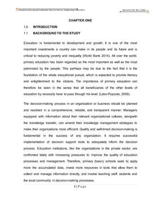
- 1. Department of Surveying and Geoinformatics Final Year Project by: Danjuma Suraju (HSG/12/0071) Supervised by Mal. Aliyu A. Zailani 1 | P a g e CHAPTER ONE 1.0 INTRODUCTION 1.1 BACKGROUND TO THE STUDY Education is fundamental to development and growth. It is one of the most important investments a country can make in its people and its future and is critical to reducing poverty and inequality (World Bank 2014). All over the world, primary education has been regarded as the most important as well as the most patronized by the people. This perhaps may be due to the fact that it is the foundation of the whole educational pursuit, which is expected to provide literacy and enlightenment to the citizens. The importance of primary education can therefore be seen in the sense that all beneficiaries of the other levels of education by necessity have to pass through his level (Labo-Popoola, 2009). The decision-making process in an organization or business should be planned and resolved in a comprehensive, reliable, and transparent manner. Managers equipped with information about their relevant organizational cultures, alongwith the knowledge transfer, can amend their knowledge management strategies to make their organizations more efficient. Quality and well-timed decision-making is fundamental in the success of any organization. It requires successful implementation of decision support tools to adequately inform the decision process. Education institutions, like the organizations in the private sector, are confronted lately with increasing pressures to improve the quality of education processes and management. Therefore, primary (basic) schools seek to apply more the accumulated data, invest more resources in tools that allow them to collect and manage information directly, and involve teaching staff, students and the local community in decision-making processes.
- 2. Department of Surveying and Geoinformatics Final Year Project by: Danjuma Suraju (HSG/12/0071) Supervised by Mal. Aliyu A. Zailani 2 | P a g e Education systems in Kano State are facing new challenges to improve quality, efficiency and relevance on the one hand, and to respond to the ever-changing needs of their economies and domestic and regional labour markets. This required the establishment and institutionalization of a comprehensive decentralized Educational Decision Support Systems (EDSS) in the state which is formally structured and designed to collect, maintain and supply relevant, reliable and timely information to guide educational policy, planning and management decisions. Ratio of Teachers per pupil in primary school Kebbi State Universal Basic Education Board (SUBEB) was formed as regulatory and control parastatals in educational sector. It is a new formation in the overall structure of the state education system. With expansion in the school curriculum and the Millennium education challenges, information management of the large number of schools and students becomes more challenging. The Educational system in Kebbi State has been in Systematic decline for over a decade. In response to this situation the government embark on the improving the education system and the lines of millions of Primary School aged children. The government is trying to put education at the forefront of its administration. About 30% of the Primary schools in the urban areas run double shift, this is attributed to the Population concentration makes most of this areas. There are over 2 million Primary School children in Kano State (47.7% female and 52.3% male). According to ESSPIN report (2012) the primary school teacher ratio is 42 pupils per teacher. There are approximately 23,000 primary class rooms, 94.4% of
- 3. Department of Surveying and Geoinformatics Final Year Project by: Danjuma Suraju (HSG/12/0071) Supervised by Mal. Aliyu A. Zailani 3 | P a g e which are usable, approximately 87 pupils per class room in primary, 35.4% of primary class room have sufficient seating and 61.5 have a good blackboard. 47.4% have no toilets; the average pupil to toilet ratio is 200:1. The worst LGA for pupil to toilet ratio at primary level is Nassarawa LGA with a ratio of 1214 pupil per toilet. According to Burrough, (1998) GIS is a powerful set of tools for collecting, storing, retrieving at will, transforming and displaying spatial data from the real world for a particular set of purposes and Smith et al (1987) lamented that GIS is a database system in which most of the data are spatially indexed and upon which a set of procedure operated in order to answer queries about spatial entities in the database. It is a decision support system that involves the integration of spatially referenced data in a problem solving environment. While (ESRI) Environmental Systems Research Institute, California (1990), defined GIS as an organized collection of computer hardware, software and personnel to efficiently capture, store, update, manipulate, analyse and display all forms of geographically referenced information. “GIS is a computer based information system which attempts to capture, store, manipulate and display spatially referenced data (in different points in time), for solving complex research, planning and management problem.” (Fischer and Nijkamp, 1993) School mapping comprises physical location analysis of the primary schools. In order for this to be accomplished knowledge of the settlements and population of the area is required. Accessibility analysis is done on the basis of the location and attributes of roads, houses, and other infrastructures as layers. Accessibility and spatial analyses make it easy for necessary decisions to be made (Hite, 2008). GIS is a system of hardware, software and procedure designed to support
- 4. Department of Surveying and Geoinformatics Final Year Project by: Danjuma Suraju (HSG/12/0071) Supervised by Mal. Aliyu A. Zailani 4 | P a g e the capture, management, manipulation, analysis, modularity and display of spatially referenced data for solving complex planning and management problems. “(Nyerges, 1992) GIS is a computer system capable of assembling, storing, manipulating and displaying geographically referenced data i.e. data identified according to their locations. “(Aronoff, 1989). World Bank recommended that the following data were needed for rationalizing and drawing up of both the urban and rural school map. Schools which includes physical aspects, site, type of building, usage, capacity, teachers (numbers, qualification, and age), students enrolment in school, individual data on age, sex, previous schools, home, location, mode of transport, time taken in home/school journey, parental background, rural and urban area data which include land use administration map on a large scale, planning reports, settlement patterns etc. The facility also includes classrooms, toilets, furnishings, materials and supplies, fire suppression systems, security, information technology etc. The school infrastructure consists of mechanical, plumbing, electrical and power, telecommunications etc (World Bank, 2014). Several studies have examined the locational planning and their attendant consequences on achievement of students in various states of the Federation. The studies were intended to assist decision makers of various states to decide where a particular type of school should be located or the size of school in each location, whether a new school should be built or otherwise among others. Among the studies some has shown mapping the distribution of facilities and analyzing to show how the schools are distributed, it could be clustered, dispersed or randomly distributed and to see whether the facilities serves the people of the area (Olubadewo, 2013).
- 5. Department of Surveying and Geoinformatics Final Year Project by: Danjuma Suraju (HSG/12/0071) Supervised by Mal. Aliyu A. Zailani 5 | P a g e Geographic information system (GIS) application are tools that allow users to create interactive queries, analyze spatial information, edit data, maps and present results of such operations. GIS Establishes a relationship between school information and their geographical location. For example, when determining the location of a school, the application of GIS tool like Geographic Positioning System (GPS) will help to identify the schools. GIS is a versatile tool that allows schools information to be displayed as maps (Ige, 2009). The focus of the project is to emphasize the use or applicability of GIS in determining the location and facilities of public and private primary schools, create school mapping and help decision makers to know the problems which are related to location and facilities in easily and quickly. The Global positioning System (GPS) is a relatively new concept in position fixing in surveying. It is a satellite based system for rapid determination of position fixation practically on the earth (land, air or sea) and at any time with pin-point accuracy. The latest technology uses a specialized radio receiver called GPS receiver. It is designed to detect radio signals transmitted from the satellites and calculate positions based on such signals. Receivers intended for geodetic surveys have better accuracy and has an interface that allows rapid data collection. Additionally, in using the GPS for geodetic works, inter-visibility amongst stations is not required. The Global positioning System (GPS) has completely revolutionized the field of surveying and geo-informatics. It is a system that has many applications in various fields ranging from geodetic positioning, control densification, hydrographic surveying, mining surveying, etc. Its main advantage is in the economy of time and labor, culminating in the reduction of project cost (Idowu, 2003). GPS is a space satellite system that
- 6. Department of Surveying and Geoinformatics Final Year Project by: Danjuma Suraju (HSG/12/0071) Supervised by Mal. Aliyu A. Zailani 6 | P a g e provides accurate information (altitude, bearings, and coordinates of points in absolute terms in three dimensions) to all users. These coordinates which are either rectangular coordinates (X, Y, Z) or geographical coordinates (φ, ,ג h), plus other quantities of interest are referenced to a particular ellipsoidal datum, the WGS84 datum. In GPS positioning, like in many other geodetic applications, the observed values are usually processed using a least squares procedure to obtain the estimates of parameters of interest. This does not require any information about the statistical distribution of observed values to estimate the parameters. However, information on the statistical distribution of the data and results are needed to determine the quality of the observations and hence the reliability of the parameters. Therefore, a statistical testing procedure to determine whether or not to accept the results relies solely on the statistical distribution of the observed quantities used in the least squares procedure. Although, GPS has become a handy tool for surveying and mapping, statistical distribution of its measured data, which forms the basis for testing the reliability of its results, has not been practically determined. It is in light of the above, that the researcher wishes to investigate the distribution of all the post primary schools in the study area. Digital mapping has now become an indispensable tool in solving many environmental-based problems. The method used for producing digital maps are many, depending on the level of details required, the use to which the map will be put and the source of data. Amuyunzu and Bijl (1999) successfully produced a digital map of elephant habitats in Kenya. The procedure of mapping land cover involved three stages:
- 7. Department of Surveying and Geoinformatics Final Year Project by: Danjuma Suraju (HSG/12/0071) Supervised by Mal. Aliyu A. Zailani 7 | P a g e (1) data collection and pre-processing. (2) Defining land cover types for the elephant habitat suitability rating model and (3) Use of a decision rule to obtain the defined classes from satellite imagery. 1.2 STATEMENT OF THE RESEARCH PROBLEM Lack of map showing the distribution pattern of the schools in the study area has made it very difficult for people to see at a glance how these schools are spread. This has necessitated the need to have a map that will show the distribution pattern of the primary schools in Birnin Kebbi L.G.A of Kebbi State. Also, to my knowledge, the use of statistical analysis to determine how and where these schools are located has not been utilized 1.3 AIM AND OBJECTIVES OF STUDY 1.3.1 Aim The aim of this study is to the spatial distribution of public and private primary schools in Birnin Kebbi Local Government Area with a view to aid planning and decision making. 1.3.2 Objectives The specific objectives of the study are to: 1. Map the location of public and private primary schools in Birnin Kebbi Local Government Area; 2. To create a geo-database of the schools in Birnin Kebbi Town, Kebbi State 3. To create attribute table of all primary school Birnin Kebbi Town, Kebbi State 1.4 JUSTIFICATION FOR THE STUDY In the past, few attempts and initiatives involving GIS at the State level by the Ministry of Land & Physical Planning at which GIS unit was created but little was
- 8. Department of Surveying and Geoinformatics Final Year Project by: Danjuma Suraju (HSG/12/0071) Supervised by Mal. Aliyu A. Zailani 8 | P a g e achieved. The main issue is that there is inadequate digital infrastructure as digital base maps, information technologies and geographic/spatial coverage’s in metropolis. Though the lists of all the public facilities are available, but lack of precise knowledge of how they are spatially distributed, this makes planning and decision making very difficult in the study area. This necessitates the government in the creation and establishment of Kebbi Geographic information System (KANGIS) in 2014, which is a parastatal under the same ministry. As a step towards improving the standard of public and private primary schools’ education in the study area, it will be necessary to provide the public and decision makers of the state with information such as location, staff strength, available facilities, status of public and private primary school, to enhance proper planning and decision making. The information provided will enable the government and educationists in policy and decision making such as planning for the future expansion, distribution of materials or facilities among these schools in the study area. 1.5 SCOPE AND LIMITATION The scope of this project is formal education and it is limited to the distribution of public and private primary schools in Birnin Kebbi Local Government Area, Kebbi State. 1.6 STUDY AREA 1.6.1 Location Education in Birnin Kebbi has a long history of Educational pursuit dating back to the post jihad years, when the area came under the influence of the Caliphate,
- 9. Department of Surveying and Geoinformatics Final Year Project by: Danjuma Suraju (HSG/12/0071) Supervised by Mal. Aliyu A. Zailani 9 | P a g e during which it witnessed the development of Islamic education. At present there are a number of informal Islamic and Quranic schools in Birnin Kebbi. As at 1998, the state had a total of 999 primary schools with a total enrolment of 316,669 pupils made up of 213,286 males and 103,383 females. Some 973 of these schools are owned by the state with only twenty six in private hands. There are about 7,280 teachers (5,750 males and 1,530 female). 1.6.2 Climate The climate of the area is a microclimate setting of the Nigeria as it is influenced by the movement of the two air masses, the maritime air masses originating over Atlantic Ocean and the dry air masses coming from the Sahara desert. Consequently, the area is characterized by wet season (May - September) which is characterized by south western maritime winds that carry warm and humid air; the dry season (October – April) is characterized by the tropical dry continental wind (Harmattan) from north. In fact, it is a tropical wet and dry type (AW) by Koppen’s classification (Umar, 2009). 1.7 SIGNIFICANCE OF THE STUDY The significance of this study is that it will promote an effective distribution of primary schools in study area. 1.8 GEOSPATIAL ANALYSIS Geospatial analysis is an approach to applying statistical analysis and other information techniques to data which has a geographical or geospatial aspect. Such analysis would typically employ software capable of geospatial.
- 10. Department of Surveying and Geoinformatics Final Year Project by: Danjuma Suraju (HSG/12/0071) Supervised by Mal. Aliyu A. Zailani 10 | P a g e 1.9 PLANNING OF THE PROJECT The project planning is carried out in five (5) different phases as follows; i. Site View (Recce) ii. Data Acquisition Phase iii. Data Processing Phase iv. Database Design and Creation Phase v. Information Presentation Phase 1.10 OPERATIONAL DEFINITION OF TERMS Primary Education: The first stage of formal education in a range of basic subjects. Universal Primary Education (UPE): an educational programme made compulsory by the Federal Government for all children in the states of the federation in 1976. Universal Basic Education (UBE): A 9 year educational programme starting from primary to junior secondary level in Nigeria. School: A place of teaching and learning of skills, knowledge and aptitudes. School Location: The geographical location of the school. School Facility: Are one of the basic educational requirements, and it is necessary to maintain safe and high-quality school facilities from the perspective of maintaining and improving educational levels in line with the developmental stage. Pupil: A child at school, who is being taught in a primary school. Teacher: All those persons in schools who are responsible for the education of pupils.
- 11. Department of Surveying and Geoinformatics Final Year Project by: Danjuma Suraju (HSG/12/0071) Supervised by Mal. Aliyu A. Zailani 11 | P a g e Pupil-Teacher Ratio: Otherwise called “student-teacher ratio” or “students per teacher”, this indicator expresses the average number of pupils (students) per teacher in a given school-year. Pupil-Classroom Ratio (PCR): The ratio of the number of pupils (students) to the number of classrooms. UNESCO: United Nations Education Scientific and Cultural Organization. UBE: Universal Basic Education. RKMP: Reviewed Metropolitan KebbiPlan. Geographical Information System: Is a computer system designed to capture, store, manipulate, analyze, manage and present all types of spatial or geographical data. Spatial: It is the data or information that identifies the geographic location of features and boundaries on earth such as a natural featurs. School: Is an institution for the teaching of children. Primary: First in order in any series, sequence. GPS: Global Positioning System
- 12. Department of Surveying and Geoinformatics Final Year Project by: Danjuma Suraju (HSG/12/0071) Supervised by Mal. Aliyu A. Zailani 12 | P a g e Figure. 1.1: The study area: Birnin Kebbi Local Government Area
- 13. Department of Surveying and Geoinformatics Final Year Project by: Danjuma Suraju (HSG/12/0071) Supervised by Mal. Aliyu A. Zailani 13 | P a g e CHAPTER TWO 2.1 LITERATURE REVIEW Millennium Development Goal In this priority area the millennium development goal is to ensure that by the year 2015, children everywhere, boys and girls alike, will be able to complete a full course of primary schooling and those girls and boys will have equal access to all levels of education (Susan, 2004). Definition of Basic Education United Nations Economic, Scientific, and Cultural Organization (UNESCO) define basic education as the first nine years of schooling; the first five or six years are often identified as primary education and the rest as lower secondary education. It also includes basic education for youth and adults who did not have the opportunity to complete a full cycle of primary education (Ikpasaja, 2014). This is the education which every Nigerian receives between the ages of three (3) and fourteen (14) years. It consists of the Early Childhood, Primary, Junior Secondary, as well as Adult and Non-Formal Education. The agency which coordinates the affairs of this sub sector is the Universal Basic Education Commission (UBEC). Other coordinating agencies in this sector include National Commission for Nomadic Education and National Mass Education Commission. 2.2 PRIMARY EDUCATION The successful acquisition of primary education and life skills competencies is a prerequisite for secondary and higher education and for many categories of vocational training, and should build on the cognitive skills development of ECCE. Its importance has been recognized in the global drive for Education All (EFA) by
- 14. Department of Surveying and Geoinformatics Final Year Project by: Danjuma Suraju (HSG/12/0071) Supervised by Mal. Aliyu A. Zailani 14 | P a g e the year 2015. The main goals and objectives of primary education are as follows (Federal Ministry of Education, 2003): i. To develop proficiency in literacy, numeracy and communication skills; ii. To develop the individuals self-confidence and ability to solve problems; iii. To foster the development of a positive self-image and self-worth; iv. To nurture moral and spiritual development and responsible action; v. To develop independent critical thinking and creativity; vi. To develop good interpersonal skills and in interaction with family, community and others; vii. To develop a culture and practice of conflict resolution; viii. To develop the ability to source information through use of library and electronic devices; ix. To nurture respect for the rights and dignity of others; x. To develop a sense of appreciation, care and protection for the environment; xi. To develop health and physical fitness; xii. To nurture sensitivity to cultural diversity; 2.3 NATIONAL POLICY ON EDUCATION 2.3.1 Universal Primary Education (UPE) Universal Primary Education (UPE) is a goal stated in many national development plans and pursued with vigour by governments of most developing countries. Primary education is seen as the first step in laying the foundation for future educational opportunities and lifelong skills. Through the skills and knowledge imbued, primary education enables people to participate in the social,
- 15. Department of Surveying and Geoinformatics Final Year Project by: Danjuma Suraju (HSG/12/0071) Supervised by Mal. Aliyu A. Zailani 15 | P a g e economic and political activities of their communities to their fullest potential (Globalisation of Education Policies, 2000). In 1976, the Universal Primary Education (UPE) programme was introduced in the country and was launched on Monday 6th September by the Olusegun Obasanjo Military Administration at Oke Sunna Municipal Primary School, Lagos to provide free and compulsory education to children at the primary school level. Unfortunately, the Scheme was faced with several challenges because structures were hurriedly put in place, teachers were trained haphazardly and there was an inadequate funding of the primary education sector. This however, brought about declining enrolment in public primary school. Teachers to pupil’s ratio were high and at the long run, education was meant only for the wealthy children (not for all the children as proposed earlier). Children who are supposed to be in the school learning are outside the street hawking goods for their parents. The vision of Education for All (EFA) regardless of their socio-economic background was ignored (Omotere, 2010). 2.3.2 Universal Basic Education (UBE) Universal Basic Education (UBE) is a reformed programme in Nigeria’s basic education delivery (from primary one, all through to junior secondary school class 3) and is to reinforce the implementation of the National Policy on Education (NPE) in order to provide greater access and ensure quality throughout the Federation as it is free and compulsory (Adomeh et al, 2007). Nigeria is adopting Universal Basic Education (UBE) and as a process of fulfilling the aim of Education For All (EFA) as endorsed at the World conference on education held in Jomtien, 1990 (Arhedo, 2009). The UBE Programme is a nine
- 16. Department of Surveying and Geoinformatics Final Year Project by: Danjuma Suraju (HSG/12/0071) Supervised by Mal. Aliyu A. Zailani 16 | P a g e (9) year basic educational programme, which was launched and executed by the government and people of the Federal Republic of Nigeria to eradicate illiteracy, ignorance and poverty as well as stimulate and accelerate national development, political consciousness and national integration. Former President Olusegun Obasanjo flagged off UBE on 30th September 1999 in Sokoto State. The UBE scheme was put in place to improve on the limitations of Universal Primary Education (UPE) of the 1970s (UBE 2014). One of the objectives of the UBE scheme that bothers on availability as relates to even spread (as stated by the Federal Ministry of Education (1999) is developing in the entire citizenry a strong consciousness for education and a strong commitment to its various promotion. It is quite obvious from the above phenomenon that the objective of developing the entire citizenry cannot be achieve unless the public education facilities are evenly distributed over the country’s landscape taking into consideration the local population density and land area coverage per school (Olamiju 2011). According to Omotere (2010), Universal Basic Education is broader than Universal Primary Education, which focused on providing educational opportunities for primary school age children. Universal Basic Education stresses the inclusion of girls and women and a number of non-privilege groups: the poor, street and working children, rural and remote populations, nomads, migrant workers, indigenous people, minorities, refugees and the disabled. It also extends to the first level of secondary education (JSS 3).
- 17. Department of Surveying and Geoinformatics Final Year Project by: Danjuma Suraju (HSG/12/0071) Supervised by Mal. Aliyu A. Zailani 17 | P a g e 2.4 UNIVERSAL BASIC EDUCATION STATEMENT At the end of 9 year of continuous education, every child through the system should have acquired appropriate level of literacy, numeracy, communication, manipulative and life skills and be employable, useful to himself and the society at large by possessing relevant ethical, normal and civic skills. It stated further that, Universal Basic Education shall: Serve as a prime energizer of a national movement for the actualization of the nation’s Universal Basic Education vision working in contact with all stakeholders thus, mobilizing the nation’s creative energies to ensure that, Education For All (EFA) becomes the responsibility for all (UBE, 200). Moreover, the objectives of the Universal Basic Education (UBE) stated in the implementation guidelines are as follows (UBE, 2000): i. Ensure unfettered access to nine (9) years of formal basic education; ii. The provision of free, Universal Basic Education for every Nigerian child of school going age; iii. Reducing drastically the incidence of drop-out from the formal school system, through improved relevance, quality and efficiency; and iv. Ensuring the acquisition of appropriate levels of literacy, numeracy, manipulative, communicative and life skills as well as the ethical, moral and civic values needed for laying a solid foundation for life-long learning. 2.5 LAWS AND OTHER BASIC REGULATIONS CONCERNING EDUCATION IN NIGERIA The National Policy on Education was enacted in 1977 and undergone three revisions, the most recent one in 2003. Since 1981, a number of decrees have
- 18. Department of Surveying and Geoinformatics Final Year Project by: Danjuma Suraju (HSG/12/0071) Supervised by Mal. Aliyu A. Zailani 18 | P a g e been passed providing the legal framework of education in the country (International Bureau of Education (IBE) - UNESCO, 2006). i. The Decree No. 16 of 1985 places special emphasis on the education of the gifted and talented children within the National Policy on Education. ii. The National Commission for Mass Literacy, Adult and Non-formal Education, which was established by Decree No. 17 of 26 June 1990 and formally inaugurated on 5 July 1991, is charged with the responsibility of developing strategies, coordinating programmes, monitoring and promoting literacy and post-literacy programmes nationwide. iii. The Decree No. 96 of 1993 re-established the National Primary Education Commission (NPEC). It also provides the arrangement for funding primary education in the country. iv. In 1993, the National Minimum Standards and Establishments of Institution Amendments Decree No. 9 was promulgated. It provides for religious bodies, non-governmental organizations and private individuals to participate in the provision of tertiary education. v. By a recent decree, all companies operating in Nigeria which have up to 100 employees on their payroll shall contribute 2% of their pre-tax earnings to the Education Tax Fund for the funding of education. vi. The most crucial strategy for sustainable education development in Nigeria is the Universal Basic Education (UBE) Scheme, which was launched in 1999. In May 2004, the Nigerian Legislature passed the UBE bill into law. The Universal Basic Education Act represents the most significant reform and addresses comprehensively the lapses of the Universal Primary Education (UPE) and the issues of access, equality, equity, inclusiveness, affordability and quality.
- 19. Department of Surveying and Geoinformatics Final Year Project by: Danjuma Suraju (HSG/12/0071) Supervised by Mal. Aliyu A. Zailani 19 | P a g e 2.6 THE STATE OF EDUCATION IN NIGERIA OF THE NATION The federal government reported that the falling standard of education in Nigeria is caused by "acute shortage of qualified teachers in the primary school level." It is reported that about 23% of the over 400,000 teachers employed in the nation's primary schools do not possess the Teachers' Grade Two Certificate, even when the National Certificate of Education (NCE) is the minimum educational requirement one should posses to teach in the nation's primary schools (Africa Economic Analysis (2008). Due to lack of teachers, however, holders of the Teacher’s Grade II Certificates (TC II) are still allowed to teach in some remote primary schools (Better Future Foundation Amodu (BFFA) – Nigeria, (2014). 2.7 FURTHER EDUCATION FOR TEACHERS Courses and other appropriate facilities should be so designed as to enable teachers to improve their qualifications, to alter or enlarge the scope of their work or seek promotion and to keep up to date with their subject and field of education as regards to both content and method. Measures should be taken to make books and other material available to teachers to improve their general education and professional qualifications (UNESCO and Human Rights, 1996). 2.8 STANDARDS Standards are set of yardsticks in the units of measurement of variables which appear in the statement of principles. Standards are not absolute but relative and are more or less a form of guides.
- 20. Department of Surveying and Geoinformatics Final Year Project by: Danjuma Suraju (HSG/12/0071) Supervised by Mal. Aliyu A. Zailani 20 | P a g e 2.8.1 Standards for Setting of Public Primary School United Nations Education Scientific and Cultural Organization (UNESCO) standard (1996): (UNESCO) prescribed the ratio of 1:25 in public primary schools. (Chukwu, 2011). Universal Basic Education Plan, (2010-2019): reveals that, for effective teaching and learning, the teacher/pupils ratio shall be 1.35 in primary schools (Kakuri, nd), and with the walking distance (3-4km) for all learners of primary school-going age Federal Ministry of Education - FMoE (2009). Reviewed Kebbi Metropolitan Plan - RKMP (1980): reveals that, the standards for the creation of public primary school as 5km service radius, 50 pupils per class, teacher-pupil’s ratio of 1:50, population threshold of 1-16,000 and age bracket of 6-13 (Tijjani, 2005). 2.9 SCHOOL MAPPING (SM) School Mapping (SM) is also to investigate and ensure the efficient and equitable distribution of resources within and between school systems when large‐scale reform or significant expansion of an educational system takes place (Caillods, 1983). Hite (2004) lamented that, school mapping as a technical exercise has become a relatively normalized and institutionalized practice in education’s planning. More than simply being a tabular, graphical or cartographical representation of a particular space or place, school mapping involves the consideration and inclusion of various forms of technical data that impact and populate the physical and social context of analysis. School mapping comprises physical location
- 21. Department of Surveying and Geoinformatics Final Year Project by: Danjuma Suraju (HSG/12/0071) Supervised by Mal. Aliyu A. Zailani 21 | P a g e analysis of schools. In order for this to be accomplished knowledge of the settlements and population of the area is required. 2.10 GEOGRAPHIC INFORMATION SYSTEM (GIS) Geographic Information System (GIS) is a powerful set of tools for collecting, storing, retrieving at will, transforming and displaying spatial data from the real world for a particular set of purposes (Burrough, 1998). GIS is capable of acquiring spatially indexed data from a variety of sources, changing the data into useful formats, storing the data, retrieving and manipulating the data for analysis, and then generating the output required by a given (Fischer and Nijkamp, 1993). GIS provides numerous benefits for the educational process, including the development of students’ geographic skills by helping them to think spatially and analyze spatial data, the promotion of student and teacher motivation, and facilitation of project-based teaching and learning (Sincekara and Karakuyu, 2010). Geographic Information System is a discipline for capturing, storing, analyzing, managing and presenting data and associated attributes which are spatially referenced to Earth. The use of GIS in Education involves combining statistical inferences to geographic information. Statistics in education might be used with GIS to present a clear picture of educational facilities and activities such as ratio of students to teacher, number of students in a class and student density in school and schools distribution in district (Eray, 2012).
- 22. Department of Surveying and Geoinformatics Final Year Project by: Danjuma Suraju (HSG/12/0071) Supervised by Mal. Aliyu A. Zailani 22 | P a g e 2.11 RELATED STUDY In the study of Sule, Abdullahi and Bungwon (2012), private primary school locations in Kaduna metropolis were determine by the use of handheld GPS receiver. Thematic map, Nearest neighbour and Buffer zone analysis reveals that, the schools are not evenly distributed as some areas have the schools concentrated at particular places while some areas have none, and some settlements are deficient in private schools while others have excess. In another study in Yola North LGA, Adamawa state by Aliyu (2013) clearly depicts the process of using Thematic map and Nearest neighbour analysis in determining the distribution pattern of the post-primary schools. The study reveals how the schools were located on digital map and shows that random pattern of distribution exists within the study area. The potentials of GIS technology in database design and creation has been demonstrated and found to be more efficient than the manual approach. The use of GIS for analyzing the distribution of facilities is not new in KebbiState, like the study of Ahmed M. et al (2013) where thematic map and nearest neighbourhood analyses were used and found out that the pattern of distribution of Police Stations in KebbiMetropolis is generally random and uneven, with a little clustering at the center. One and two kilometre buffer zones were generated and the result shows that the old city of Kebbiand the eastern part of the metropolis were fully served while the west and southern part were underserved. Also, in another research conducted by, Kibon and Ahmed (2013), where they made use of thematic map and nearest neighbour analysis shows that, the distributions of Health facilities in KebbiMetropolis are in clustered.
- 23. Department of Surveying and Geoinformatics Final Year Project by: Danjuma Suraju (HSG/12/0071) Supervised by Mal. Aliyu A. Zailani 23 | P a g e The study of Olubadewo, Abdulkarim and Ahmed (2013), indicates the use of technology (GIS) for education planning have proved to be very important in the decision making in Fagge L.G.A by providing the planners integrated geographic scenario of location of school. The Thematic map and Nearest neighbour analysis shows that the distribution of primary schools in the area is more concentrated than other areas, while the buffer zones show that schools are closer to roads and Markets. The database shows there are 222 classrooms, 12,693 pupils and 558 teachers in the areas at which the result shows a perfect significant relationship between the number of teacher and pupils. The tool of the analysis (Nearest Neighbour) was used to analyze the pattern of the distribution and the result shows the schools are dispersed. 2.12 DISTRIBUTION OF SCHOOLS Distribution of schools has an effect on the participation rate in school education geographic location of primary schools as indeed public facilities in Nigeria has not taken into account inequalities among region, different social groups and geographical area (Ikpasaja, 2014). According to Heinzle (2014), urban development as well as the construction of transportation routes follows usually structural conditions. Economical rules, security issues or the best possible utilisation of terrain are some basic principles for the emergence of typical structures in road networks. The knowledge of such patterns provides information about the design, history and development of an urban area as well as the functional organisation of a town. Urban geography is a domain which studies the inner structure of cities, especially complex patterns of distribution, movement, flows and interaction within cities. It provides various
- 24. Department of Surveying and Geoinformatics Final Year Project by: Danjuma Suraju (HSG/12/0071) Supervised by Mal. Aliyu A. Zailani 24 | P a g e categorisations of types of cities on the basis of their historic development as well as on the basis of their today’s appearance, functional and social organization. Some basic forms or patterns to be detected in urban road networks are; i. Strokes – as a linear configuration; ii. Grids – as a cellular configuration; iii. Stars – as a radial configuration, and iv. Ring roads – as a cellular configuration, observed over a wider area. Usually roads play an important role in those categorisations, because they constitute the linkage system between different regions and land uses.
- 25. Department of Surveying and Geoinformatics Final Year Project by: Danjuma Suraju (HSG/12/0071) Supervised by Mal. Aliyu A. Zailani 25 | P a g e CHAPTER THREE METHODOLOGY 3.1 DATA SOURCES, ACQUISITION AND PROCESS To achieve the objectives of the study, the methodology engaged the use of primary and secondary data. The primary sources include hand-held Global Positioning System (GPS) receiver for capturing the coordinate points of the public primary schools, while the secondary data used Digital Map imagery, population figures of pupils, teaching staff, names and address of the public primary schools in Birnin Kebbi Local Government Area. 3.2 DATA ACQUISITION Data was capture using different techniques and methods, those data are divided in to two categories namely. a) Primary data b) Secondary data 3.2.1 PRIMARY DATA These are data that were captured directly on the field. The Data were captured through GPS observations, in which hand-held GPS receiver was used to determine the coordinate of the primary schools. These coordinates are the Northings and Easting.
- 26. Department of Surveying and Geoinformatics Final Year Project by: Danjuma Suraju (HSG/12/0071) Supervised by Mal. Aliyu A. Zailani 26 | P a g e Table: 3.1 Coordinates used to geo-reference the map S/NO NAMES OF ROUNDABOUT EASTING NORTHING 1. Sky Bank 630864 1376238 2. SSS/Police H/Q 636752 1377972 3. House of Assemble 633247 1376536 4. NNPC/Welcome to Birnin Kebbi 637239 1370063 5. Jega Roundabout 629795 1374394 3.2.2 SECONDARY DATA The data was obtained from the Kebbi State universal basic education (SUBEB) through verbal interaction which includes the following: 1. Names of the existing schools 2. Names of the located of schools 3. Year of establishment of the schools 4. Number of teaching 5. Number of students 6. Number of classrooms each school has, etc. 3.3 MATERIALS /EQUIPMENT USED Hand held GPS (Garmin 72H) Laptop computer (HP) HP jet printer Flash-drive Scanner 3.3.1 SOFTWARE USED Arc GIS 9.2 Microsoft Excel
- 27. Department of Surveying and Geoinformatics Final Year Project by: Danjuma Suraju (HSG/12/0071) Supervised by Mal. Aliyu A. Zailani 27 | P a g e FLOW CHART DIAGRAM Fig. 3.1: Flow chart diagram
- 28. Department of Surveying and Geoinformatics Final Year Project by: Danjuma Suraju (HSG/12/0071) Supervised by Mal. Aliyu A. Zailani 28 | P a g e 3.4 GEOREFERENCING Geo-referencing is the act of defining the limit of a geographical entity of the reference map in relation to its coordinate. The map was exported into ArcGIS, with this done; geo-referencing of the map was carried out using some coordinates of major roundabouts of the study area. The processes are: 1. Click the geo-referencing icon to geo-reference the map. 2. Right click to input X, Y coordinates, and then click ok. 3. Input he coordinates of the entire roundabout one after the other, were at his point the map was properly geo-referenced. To finish Geo-referencing, click on “Geo-referencing” menu item from the toolbar, and select “update geo-referencing” were at this stage the map was properly geo-referenced. 3.5 DIGITIZING Is a process of tracing of raster image either as a point, polyline and/or polygons in to different layers that have been created. The spatial entities used in digitizing are point, polyline and polygon. Polyline is used to represent linear feature e.g. road. However, before digitizing you may bring all the layers that have been created before in to Arc Map from Arc Catalog 3.5.1 PROCEDURES: In ArcGIS, all digitizing occurs in within Editor. To start digitizing: 1. Click on the Editor Button 2. On the Editor tool bar select start Editing 3. Select the feature that you want to digitize 4. Click on sketch tool icon. 5. Use your mouse to draw in the feature e.g. road. 6. Click once to create a vertex (starting point) and right click to select finish part to end a particular line.
- 29. Department of Surveying and Geoinformatics Final Year Project by: Danjuma Suraju (HSG/12/0071) Supervised by Mal. Aliyu A. Zailani 29 | P a g e Fig. 3.2: Digitized of the Area under Study 3.6 PROCEDURE OF CREATING LAYERS Layers were created so as to be able to display picture of different features. The following are the procedure of creating layers in ArcGIS 1. Click ArcCatalog 2. Select connect folder 3. Right click your folder 4. Click New 5. Go to sharp file 6. and click 7. On shape file, name the features (layer) to be created e.g. point, road is a polyline pick polyline. 8. Go to Edit and click 9. Pick select 10. Select Geographical Coordinate System, Africa, Minna. Pro, and Add, Apply then click ok and ok again.
- 30. Department of Surveying and Geoinformatics Final Year Project by: Danjuma Suraju (HSG/12/0071) Supervised by Mal. Aliyu A. Zailani 30 | P a g e Fig. 3.3: Procedure of Creating a Layer 3.7 MAP OF LAYERS CREATED The Following are Layers Created Layer 1: Primary Schools Layer 2: Area Layer 3: Primary Schools Buffering Layer4: Roads Table 3.2: Attribute Data SS//NN NNAAMM EESS OOFF SSCCHHOOOOLL YYEEAARR OOFF EESSTTAABBLLIISSHHMMEENNTT TTYYPPEESS OOFF SSCCHHOOOOLL LLOOCCAATTIIOONN OOFF SSCCHHOOOOLL 1 Abi Private School 1999 Nursery, Primary and secondary school Badariya Area Birnin Kebbi 2 All – Brighter Kids 2006 Nursery and School Only Opp. Sani Abacha Bye pass Gesse Phase III Birnin Kebbi 3 Al–Nura/Pri. Sch 2006 Nursery and Pri. Sch. Behid Nasari College B/Kebbi 4 Al – Hikima Nur/Pri. School 2002 Nursery, Primary and Secondary School Opp. Abdullahi Fodiyo Secondary School B/Kebbi 5 Asasul Islam 2007 Nursery, Primary School Behind Magajin Gari MPS T/Wada Birnin Kebbi
- 31. Department of Surveying and Geoinformatics Final Year Project by: Danjuma Suraju (HSG/12/0071) Supervised by Mal. Aliyu A. Zailani 31 | P a g e 3.8 OPERATION INVOLVE IN CREATING ATTRIBUTE TABLE AND LINKAGE 1. Click on the Editor Toolbar select start Editing. 2. Right click in the one of the layer e.g. transformer 3. Click open Attribute table. 4. Go to option 5. Select Add field, write the name of layer to be attributed. Selects and click ok. Fig. 3.4: Procedure of Creating Attribute Table: Procedure of Creating buffer 1. Click Arc Toolbox 2. Click on analysis tools 3. Click proximity 4. Click buffer the table will appear 5. Input feature 6. Input the distance meters / kilometers 7. Finally click “OK”
- 32. Department of Surveying and Geoinformatics Final Year Project by: Danjuma Suraju (HSG/12/0071) Supervised by Mal. Aliyu A. Zailani 32 | P a g e Fig. 3.5: Procedure of Creating Buffer.
- 33. Department of Surveying and Geoinformatics Final Year Project by: Danjuma Suraju (HSG/12/0071) Supervised by Mal. Aliyu A. Zailani 33 | P a g e CHAPTER FOUR The database creation which involves obtaining data and inputting the data will now require the following: Data Processing Data Analysis Data Presentation 4.1 DATA PROCESSING The of Birnin Kebbi was obtained from ministry of land and surveying, the coordinate of major roundabout were obtained to geo-referenced and also the coordinate of primary schools were obtained by using using hand held GPS (Garmin 72H). The ArcGIS was used to process the data observed from the field to determine the attribute and spatial databases. 4.2 DATA ANALYSIS The data was successfully digitized and retrieved adequately for presentation at different digital format. 4.2 DATA PRESENTATION The data captured, stored and integrated was represented in digital format which involves the merging of the entire segment in single software. As earlier mentioned ArcGIS was used, this is because it allows importation of image from which layers of Classes. SQL in-built in the ArcGIS was used to query the database for specific features. The resultant output is given in both graphical and numeric forms on the display.
- 34. Department of Surveying and Geoinformatics Final Year Project by: Danjuma Suraju (HSG/12/0071) Supervised by Mal. Aliyu A. Zailani 34 | P a g e Fig 4.1: Query Showing the Information of Each Primary School Fig 4.2: Query Showing the Name of Neighbourhood
- 35. Department of Surveying and Geoinformatics Final Year Project by: Danjuma Suraju (HSG/12/0071) Supervised by Mal. Aliyu A. Zailani 35 | P a g e Fig 4.3: Query Showing the Buffering of the Feature Fig 4.4: Query Showing the Spatial Distribution of Primary Schools
- 36. Department of Surveying and Geoinformatics Final Year Project by: Danjuma Suraju (HSG/12/0071) Supervised by Mal. Aliyu A. Zailani 36 | P a g e CHAPTER FIVE SUMMARY, CONCLUSION AND RECOMMENDATIONS 5.1 SUMMARY The study reveals that, there are (21) public and private (29) primary schools in the study area. The problem ranges from lack of digital school map, inadequate classrooms and teachers. The study clearly depicts the process of using Nearest Neighbour and Buffer Zone Analysis in determining the distribution pattern and catchment area of the public primary schools. The coordinates of the public and private primary schools in Birnin Kebbi Local Government were obtained using handheld GPS and was plotted using the ArcGis software. The map gave firsthand information of their spatial distribution, and other relevant information which would provide information that would help in decision making and planning. 5.2 CONCLUSION The research investigates the spatial distribution of public and private primary schools in Birnin Kebbi Local Government Area, Kebbi State. The study determined the spatial distribution of public primary schools, compared the available primary education facilities with the set standard of UNESCO (1996), UBE (2004) and Reviewed Kebbi Metropolitan Plan (1980); and assessed the qualification of teachers in public and private primary schools in Birnin Kebbi Local Government Area. The problem ranges from inadequate classrooms and teachers. The classrooms are overcrowded and teachers are overworked. This implies that schools are yet
- 37. Department of Surveying and Geoinformatics Final Year Project by: Danjuma Suraju (HSG/12/0071) Supervised by Mal. Aliyu A. Zailani 37 | P a g e to adhere to the teacher-pupils ratio of UNESCO standard, 1996 (1:25) pupils in a class, and majority (74%) of the public and private primary school teachers acquired teaching certificates. The research allows visualization of field survey results and provides essential school information. The user-friendly GIS mapping method demonstrated in this study is a practical and feasible method for field government, educationist and researches monitoring schools in a geographically academic area. 5.3 RECOMMENDATIONS Based on the analysis of result, research findings and conclusion of this study, the following recommendations were made. 1. Decongest the overcrowded classrooms to a smaller class size. 2. Government should construct modern classrooms equipped with basic amenities for the comfort of the student and teachers. 3. Additional classrooms should be constructed within the available schools premises except if there is no available space. 4. Government should adopt the vertical approach (multi-storey) building of classrooms in schools where there are no space for future expansion. 5. Government should made emphasis on the provisions of public and private primary schools base on population than service radius within the metropolitan area. 6. Government should as well reduce the service radius to the minimum of 1km within the metropolitan area. 7. That all the remaining local governments should determine the location and distribution of their primary schools using. 8. Government should use the finding as a guide together with their policies in establishing schools.
- 38. Department of Surveying and Geoinformatics Final Year Project by: Danjuma Suraju (HSG/12/0071) Supervised by Mal. Aliyu A. Zailani 38 | P a g e REFERENCE Adomeh, I.O.C, Arhedo, A. and Omoike, D. (2007). Comtemporary issues in history of education in O.O. Aluede and D.Omoike (eds): trends in history of eduction in Nigeria (pp 221-139) Agbor: Krisbec Publications 121-139 Ahmed, M. N., M. U. Mohammed and Y. IDRIS (2013). A GIS-Based Analysis of Police Stations Distributions in KebbiMetropolis. IOSR Journal of Computer Engineering (IOSR-JCE), Vol. 8, pp72-78. Arhedo, Philip Azetta PhD, Adomeh, Ilu O.C. PhD and Aluede, Oyaziwo PhD (2009). School Councellors’ Roles in the Implementation of Universal Basic Education (UBE) Scheme in Nigeria. Edo Journal of Counselling, Vol. 2. Aliyu A., M. A. Shu’aibu and R. M. Aliyu (2013). Mapping and Spatial Distribution of Post Primary Schools in Yola North Local Government Area of Adamawa State, Nigeria. International Journal of Science and Technology, 2. Better Future Foundation Amodu Nigeria (nd). Online document. Accessed on 12/07/2014. Burrough, P. A. (1998). Principles of Geographic Information System, Oxford University Press, New York. Caillods, F. (1983). School Mapping and micro‐planning in education, Module I: Training materials in educational planning, administration and facilities. IIEP/UNESCO 7 - 9, rue Eugene - Delacroix, 75116 Paris, France. Chao Yang, Qi Liu (2012): Published Online (www.mecs-press.net). Chukwu, Leonard C. (2011): Teacher/Pupils Ratio: An Indispensable Variable in a Successful Universal Basic Education (Ube) Scheme in the South East Zone of Nigeria. The Nigerian Journal of Research and Production. Vol.19, No. 1 Cybergeo (2011): An Evaluation of Road Network Patterns Based on the Criteria for Fire-Fighting. European journal of geography. Educational System Support in Nigeria – ESSPIN (2012). KebbiState annual report (2011/12) on Primary education, accessed on 29/04/2014.
- 39. Department of Surveying and Geoinformatics Final Year Project by: Danjuma Suraju (HSG/12/0071) Supervised by Mal. Aliyu A. Zailani 39 | P a g e Eray, Okan (2012). Application of Geographic Information System (GIS) in Education, Journal of Technical Science and Technologies. Federal Ministry of Education - FMoE, Nigeria (2003): Education Sector Status report, Nigeria. Federal Ministry of Education - FMoE, Nigeria (2006): Strategic Plan for Educational Enhancement and Development. Nigeria. Federal Ministry of Education, - FMoE, Nigeria (2009). Roadmap for the Nigerian Education Sector. Fischer, M. M. and P. Nijkamp (1993). Design and use of geographic information systems and spatial models, New York. Globalisation of Education Policies (2000): Extent of External Influences on Contemporary Universal Primary Education Policies in Papua New Guinea - excerpts are from the complete text of Thomas Webster - book from the University of Papua New Guinea Press. Heinzle F., K.-H. Anders and M. Sester (2014). Automatic Detection of Patterns in Road Networks - Methods and Evaluation. Institute of Cartography and Geoinformatics, University of Hannover, Appelstr. 9a, 30167 Hannover, Germany. Hite, J. S. (2008). School Mapping and GIS in Educational Micro-Planning. International Institute for Education Planning. United Nations Educational, Scientific and Cultural Organization (UNESCO), Paris, France. Ige, Olumide O.O. (2009). GIS for sustainable management of secondary schools in Ife central local government, Osun state Nigeria. Unpublished MSc project report, Regional Centre for Training in Aerospace Survey (RECTAS) Library, Ile-Ife, Osun State, Nigeria. Ikpasaja, Ernest (2014): Spatial Distribution and Accessibility to Public Primary School in Akwa-Ibom State: A case study of Uyo Local Government Area. Unpublished MSc project report, Regional Centre for Training in Aerospace Survey (RECTAS) Library, Ile-Ife,Osun State, Nigeria.
- 40. Department of Surveying and Geoinformatics Final Year Project by: Danjuma Suraju (HSG/12/0071) Supervised by Mal. Aliyu A. Zailani 40 | P a g e International Bureau of Education (IBE) – UNESCO, (2006): Laws and other basic regulations concerning education. Kibon Usman Ado and M. Ahmed (2013). Distribution of Primary Health Care Facilities in KebbiMetropolis Using GIS. Research Journal of Environmental and Earth Science. Kukari, Arnold Dr. (nd), Policy Interventions for Fast Tracking the Goal of Universal Basic Education. Senior Research Fellow and Program Leader Universal Basic Education Research Program the National Institute. Online document. Accessed on 11/08/2014. Labo-Popoola S.O., A. A. Bello and F. A. Atanda (2009). Universal Basic Education: Challenges and Way Forward. Medwell Journals, Scientific Research Publishing Company, 6, 252-259. Olamiju Isaac Oluwadare and Olujimi Julius (2011). Regional Analysis of locations of Public Educational Facilities in Nigeria: The Akure region experience. Journal of Geography and Regional Planning. Vol. 4(7), pp. 431. Olubadewo O. O, I. A. Abdulkarim and M. Ahmed (2013). the Use of GIS as Educational Decision Support System (EDSS) For Primary Schools in Fagge Local Government Area of KebbiState, Nigeria. Academic Research International, 4. Omotere, Adunola (2010): The Challenges Affecting the Implementation of Universal Basic Education in Nigeria Chapter One. Published Online By: Ego Booster Books, Osun State, Nigeria. Sani, Auwalu. Y. (2014). Personal interview. Educational Facilities and Infrastructure in Public Primary Schools in Birnin Kebbi Local Government Area. At Birnin Kebbi Local Education Authority, Birnin Kebbi LGA Kebbiwith Tijjani, A.M., 16 May 2014. Sincekara, Suleyman and Karakuyu (2010). How are Geographic Information Systems (GIS), Conferences at Faith University contributing to education in Turkey, Scientific Research and Essays, 5.
- 41. Department of Surveying and Geoinformatics Final Year Project by: Danjuma Suraju (HSG/12/0071) Supervised by Mal. Aliyu A. Zailani 41 | P a g e Sule J. O, H. S. Abdullahi and J. Bungwon (2012), Acquisition of Geospatial Database for Primary Schools in Kaduna Metropolis, Research Journal of Environmental and Earth Science. Susan J. Peters (2004). Inclusive Education: An EFA Strategy for All Children. World Bank. Online document. Tijjani, Abdulaziz. M. (2005). Planning for Educational facilities in Kebbiwall city, KebbiState, Nigeria. Unpublished Bachellor of Urban and Regional Planning (B. URP) project report, 1998/05. UPR Department Library, Ahmadu Bello University (ABU), Zaria. UNESCO (2014). Gender Equality in Education. UNESCO Bnngkok. Online document. Accessed on 22/08/2014. UNESCO and HUMAN RIGHTS (1996): Standard-Setting Instruments Major Meeting Publications. Published by United Nations educational, Scientific and Cultural Organization, 7 place de Fontenoy, Paris. UNESCO - NIGERIA TVE PROJECT (2014): Instructional/teaching materials. Online document. Accessed on 19/07/2014. Universal Basic Education - UBE (2014). The challenges affecting the implementation of Universal Basic Education in Nigeria. WORLD BANK (2014). Education is fundamental to development and growth. “The First 7”: Conference on Early Childhood Development Policies. World Bank.
- 42. Department of Surveying and Geoinformatics Final Year Project by: Danjuma Suraju (HSG/12/0071) Supervised by Mal. Aliyu A. Zailani 42 | P a g e APPENDIX I Table 1: SHOWING THE ATTRIBUTE DATA OF PRIVATE PRIMARY SCHOOLS IN BIRNIN KEBBI S/N NAMES OF SCHOOL YEAR OF ESTABLIS HMENT TYPES OF SCHOOL LOCATION OF SCHOOL NO OF STAFF NO OF MALE NO OF FEMALE NO OF CLASS PLAING GROUND NO OF POPILS NO OF BOYS NO OF GIRLS TOILET EASTING NORTHING 1 Abi Private School 1999 Nursery, Primary and secondary school Badariya area Birnin Kebbi 26 12 14 12 2 123 58 65 2 627870 1375763 2 All – Brighter Kids 2006 Nursery and School Only Opp. Sani Abacha Bye- pass Gesse Phase III Birnin Kebbi 158 2 3 Al – Nura/Pri. School 2006 Nursery and Primary School Behid Nasari College Birnin Kebbi 26 17 9 9 2 236 116 120 1 628557 1376911 4 Al – Hikima Nur/Pri. School 2002 Nursery, Primary and Secondary School Opp. Abdullahi Fodiyo Secondary School B/Kebbi 18 7 11 11 1 230 116 114 2 629028 1375858 5 Asasul Islam 2007 Nursery, Primary School Behind Magajin Gari MPS T/Wada Birnin Kebbi 7 4 3 4 1 60 30 30 2 6 B.I.C.C.E Basaura Nur/Pri. Sch. 2004 Nursery, Primary and Secondary School Junju Area, Near Fin Bank Birnin Kebbi 14 3 11 10 3 407 206 201 4 631182 1376709 7 Brilliance Nur/Pri School 1996 Nursery, Primary and College Senator Adamu Augie Road G.R.A Birnin Kebbi 14 5 9 21 2 692 341 351 3 631265 1377529
- 43. Department of Surveying and Geoinformatics Final Year Project by: Danjuma Suraju (HSG/12/0071) Supervised by Mal. Aliyu A. Zailani 43 | P a g e 8 Al – Furquan 2003 Nursery and Primary School Tudun – Wada Area Birnin Kebbi 18 14 4 10 0 303 143 160 1 630616 1378173 9 Comprehensive Nur/Pri School 2007 Nursery, Primary and Secondary School Gwadangwaji Town 20 17 3 13 2 278 135 143 2 636178 1379569 10 Destiny Int. Nur/Pri. School 2010 Nursery and Primary School Gesse Phase II Birnin Kebbi 11 Fomwan Nur/Pri School 2002 Nursery and Primary School Makerar Gandu Area B/Kebbi 11 6 5 8 2 206 97 109 2 12 Harmony Nur/Pri School 2005 Nursery and Primary School Rafina Atiku Area Birnin Kebbi 10 3 7 13 0 151 75 76 2 629636 1376241 13 Heroes Science Nur/Pri School 2009 Nursery and Primary School Gesse Phase III Birnin Kebbi 8 6 2 14 2 230 136 94 2 632028 1375205 14 High Standard Nur/Pri 2000 Nursery and Primary College Near Tambai Super Market B/K 12 5 7 16 1 520 248 272 4 630006 1374767 15 Ivory Palace Int. School 2010 Nursery and Primary School Opp. Kara Market Area B/K 9 4 5 9 1 266 134 132 2 631455 1374730 16 Joda Int. Nur/Pri Sch. 1997 Nursery, Primary and Secondary School Near Government Lodge I G.R.A Birnin Kebbi 15 7 8 22 1 643 351 292 6 631546 1377661 17 Julde Nur/Pry School 2013 Nursery Primary School Near Eastern Bye Pass Primary School 5 2 3 6 2 10 5 5 2 632310 1375254
- 44. Department of Surveying and Geoinformatics Final Year Project by: Danjuma Suraju (HSG/12/0071) Supervised by Mal. Aliyu A. Zailani 44 | P a g e 18 Solid Science Nur/Pri School 2004 Nursery, Primary and Secondary School Off. Abubakar Nadaniya MPS Badariya Area Birnin Kebbi 26 16 10 11 2 350 189 161 2 627155 1375519
- 45. Department of Surveying and Geoinformatics Final Year Project by: Danjuma Suraju (HSG/12/0071) Supervised by Mal. Aliyu A. Zailani 45 | P a g e 19 Staff Based Educ. School 1980 Nursery, Primary and Secondary School Waziri Umaru Federal Polytechnic Birnin Kebbi 28 18 10 12 1 349 291 2 629704 1377557 20 ST. James Angolical Nur/Pri School 1996 Nursery Primary and College Makerar Gandu Area Birnin Kebbi 12 7 5 10 2 193 94 99 2 629525 1377015 21 Unique Progressive 1990 Nursery and Primary School Opp. Total Filling Station Nassarawa Area Birnin Kebbi 15 3 12 9 0 187 88 99 2 629885 1375960 22 Ultimate Nur/Pri School 2004 Nursery, Primary and College Near Abdullahi Fodiyo Sec. School Tsohuwar Mayanka Birnin Kebbi 12 5 7 11 2 259 128 131 5 628855 1376239 23 Royal Leads Academy 201 Nursery, Primary and Secondary School Opp. Central market Area Birnin Kebbi 9 4 5 6 2 139 88 51 4 631156 1375435 24 Sir Haruna Rasheed 2013 Nursery, Primary School Badariya Area Birnin Kebbi 10 6 4 8 1 72 46 26 4 628780 1375942 25 N.Y.S.C Nur/Pri School 1992 Nursery, Primary and Secondary School Central Market Road Rafin Bara’u birnin Kebbi 12 5 7 12 1 433 241 192 4 631004 1376068 26 Pearl Havour Model Academic 2011 Nursery and Primary School Gwadangwaji Town Kebbi State 11 6 5 13 2 165 78 87 6 636370 1379713 27 Police Children School 2013 Nursery, Primary School Police Barracks T/Wada 18 18 0 7 1 65 41 24 2
- 46. Department of Surveying and Geoinformatics Final Year Project by: Danjuma Suraju (HSG/12/0071) Supervised by Mal. Aliyu A. Zailani 46 | P a g e 28 J. Good Foundation School 2011 Nursery and Primary School Gesse Bayero Area Birnin Kebbi 12 7 5 6 1 80 63 17 3 633366 1376209 29 Darul Ilmu 2010 Nursery, Primary and Islamiyya School Sahabi Nasarki Residence, Rafin Atiku Birnin Kebbi 12 8 4 8 1 144 73 71 2
- 47. Department of Surveying and Geoinformatics Final Year Project by: Danjuma Suraju (HSG/12/0071) Supervised by Mal. Aliyu A. Zailani 47 | P a g e Table 2: SHOWING THE ATTRIBUTE DATA OF PUBLIC PRIMARY SCHOOLS IN BIRNIN KEBBI s/n names of school year of establi shment types of school location of school no of staff no of male no of female no of class playing ground no of popil no of boys no of girls toilet easting northing 1 Abubakar Gari Malama MPS 1991 Primary school Only Gwadangaji QRTS 26 9 17 12 1 1054 667 387 4 633997 1379098 2 Abubakar Nadaniya MPS 2001 Primary and Sec. School Only Badariya Birnin Kebbi 24 6 18 27 1 1206 625 581 4 627081 1375762 3 Adamu Gulma MPS 1949 Primary and Sec. School Only Makerar Gandu, Birnin Kebbi 23 9 14 11 1 593 296 297 2 629352 1376979 4 Army Children School 1975 Nursery and Primary School Dukku Barracks Birnin Kebbi 26 13 13 18 1 1435 4 5 Atiku Bagudu Science MPS 1976 Primary and Secondary School Makerar Gandu, Birnin Kebbi 41 13 28 32 1 2267 1191 866 2 629561 1377296 6 Baiti Model Primary School 1976 Primary and Secondary School Tudun – Wada Birnin Kebbi 17 8 9 10 1 775 387 388 4 630280 1378559 7 Bayan Tasha Primary School 2002 Primary School Only Mechanic Village 22 8 14 10 1 1202 615 587 4 630368 1375169 8 Buhari Bala Primary School 1976 Primary School Only Makera Gandu, Birnin Kebbi 25 5 20 12 1 445 252 193 2 629292 1376930 9 Dr. Yahaya Shantali MPS 1976 Primary School Takalau 31 19 12 12 1 725 417 308 2 629660 1378977
- 48. Department of Surveying and Geoinformatics Final Year Project by: Danjuma Suraju (HSG/12/0071) Supervised by Mal. Aliyu A. Zailani 48 | P a g e 10 Eastern Bye – Pass MPS 2009 Primary School Only Eastern Bye – Pass Birnin Kebbi 12 5 7 6 2 429 235 194 2 632320 1375189 11 Gudi Primary School 2002 Primary School Only Gudi Takalau, Birnin Kebbi 15 12 3 11 1 429 229 200 0 629142 1378640 12 Gwandu Emirate Primary School 1995 Primary School Only Nassarawa B, Birnin Kebbi 39 13 26 15 1 784 420 364 4 630332 1376774 13 Hajiya Kubura Primary School 1976 Primary School Only Illelar Yari, Birnin Kebbi 24 7 17 11 1 653 365 288 2 628960 1377584 14 Just Ibrahim Umar Primary Sch. 1976 Primary School Only GRA Birnin Kebbi 37 14 23 7 1 421 179 242 2 630870 1378244 15 Magajin Gari MPS 1956 Primary School Only Tudun Wada, Birnin Kebbi 37 12 25 18 1 1097 569 528 4 630303 1377930 16 Magajin Rafi Bello 1975 Primary School Only Fada Junju, Birnin Kebbi 33 8 25 13 1 872 470 402 4 630943 1376663 17 Umar Ahmed Gwadangwaji 1976 Primary School Only Gwadangaji Gari, Birnin Kebbi 25 6 19 13 1 1121 645 476 4 636017 1379693 18 Umaru Illalu Primary School 1976 Primary School Only Badariya Area, Birnin Kebbi 34 7 27 11 1 657 337 320 4 628830 1375893 19 Waziri Umaru Ninzamiya “A” 1950 Primary School Only Nassarawa Birnin Kebbi 35 17 18 18 1 1089 602 487 4 630256 1376156 20 Waziru Umaru Ninzamiya “B” 2004 Primary School Only Nassarawa Birnin Kebbi 31 21 10 12 1 693 380 313 4 630200 1376101 21 Zannan Gwandu Primary School 1991 Primary School Only Gesse Quarters, Birnin Kebbi 30 10 20 12 1 674 351 323 2 632660 1377080
- 49. Department of Surveying and Geoinformatics Final Year Project by: Danjuma Suraju (HSG/12/0071) Supervised by Mal. Aliyu A. Zailani 49 | P a g e APPENDIX II HAND HELD GLOBAL POSITION SYSTEM (GPS) RECEIVER (Garmin 72G)
- 50. Department of Surveying and Geoinformatics Final Year Project by: Danjuma Suraju (HSG/12/0071) Supervised by Mal. Aliyu A. Zailani 50 | P a g e APPENDIX III PROJECT/SITE PICTURE