Over the course of three months, my research partner and I explored the three major neighborhoods of the rural farming community of San Luis de Monteverde, Costa Rica. Along the way, we made over 150 waypoints on a handheld GPS to indicate different buildings while tracking the roads and paths we walked along to get there. We then generated maps by merging this data with QGIS software and layering the data over Google satellite imagery of the area. This was the first time the map of San Luis de Monteverde had been updated in twelve years. These updated maps will aid emergency workers in improving service to the community, be a helpful resource in the community of San Luis, and allow future students and researchers to do more in-depth GPS projects.
2. Perro Proyecto
Los perros están destruyendo los bosques?
Cuánto tiempo están en el bosque?
Nosotros podemos seguir los perros con
materiales de seguimiento
Pero, las imágenes de satélite de San Luis no
ha sido actualizado desde 2002
4. Nuestro Proyecto - Un
Mapa de San Luis
Las imágenes de satélite de San Luis no se ha
actualizado desde 2002
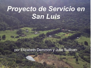
En tres viernes separados, caminamos en San
Luis y utilizamos un GPS portátil para mapear
caminos, edificios, y rios
Mapeamos los tres vecindarios más grandes
de San Luis: Alto, Invu, y Bajo
8. Conclusion
Los mapas más precisos de San Luis asegurarán
de que los trabajadores de emergencia puede
servir mejor a la comunidad
Con mapas actualizados, los futuros estudiantes
podrán seguir los perros con éxito y hacer otros
proyectos de GPS
9. Las Lecciónes Para
Nosotros
Nosotros aprendimos que no podemos seguir
los perros sin una mapa reciente
Aprendimos la importancia de las mapas en un
communidad
Phebe y Morgan nos enseñaron el programa
de GIS y como hacer las mapas en una
computadora
10. Gracias
Phebe y Morgan para
nos enseñaron sobre
GIS y GPS
Fran Lindau
La gente de San Luis
En el futuro,
posiblemente los perros
de San Luis :)