Beginners Guide to TikTok for Search - Rachel Pearson - We are Tilt __ Bright...
Kumari kandam the sunken land mass from the world map
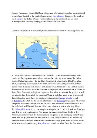
1. Kumari Kandam or Kumarikkaṇṭ am is the name of a legendary sunken landmass said
to have been located to the south of present-day Kanyakumari District at the southern
tip of India in the Indian Ocean. The legend assigns the continent and its final
submergence an antiquity ranging in tens of thousands of years.
Compare the photo above with the present map below to see how it is suppose to fit
in. Proponents say that the land mass is "Lemuria", a different name for the same
continent. The supposed sunken land seems to be covering most part of the Indian
Ocean. On the East side of the land lays Sumatera & Malaysia. In 26th December,
2004, in the very same region, the world witnessed a devastating effect of mother
nature when Tsunami took place. The tsunami is was the result of the shift in tectonic
plate in the sea bed that recorded a tremor as largely as 8.6 in richter scale. Could it be
that a Giant Tsunami, multiple times greater than what we witnessed 4 yrs & 1 month
before, strucked this part of the continent?Ancient texts has made some reference of
this said sunken land. There are scattered references in Sangam literature, such
as Kalittokai 104, to how the sea took the land of the Pandiyan kings, upon which they
conquered new lands to replace those they had lost. There are also references to the
rivers Pahruli and Kumari, that are said to have flowed in a now submerged land.
The Silappadhikaram, a 5th century epic, stating that the "cruel sea" took the Pandiyan
land that lay between the rivers Pahruli and the many-mountained banks of the
Kumari, to replace which the Pandiyan king conquered lands belonging to the Chola
and Chera kings (Maturaikkandam, verses 17-22). Adiyarkkunallar, a 12th century
commentator on the epic, explains this reference by saying that there was once a land
to the south of the present-day Kanyakumari , which stretched from the Pahruli river
2. in the north to the Kumari river in the south. This land was divided into 49 territories,
which he names as 7 coconut territories (elutenga natu), 7 Madurai territories
(elumaturai natu), 7 old sandy territories (elumunpalai natu), 7 new sandy territories
(elupinpalai natu), 7 mountain territories (elukunra natu), 7 eastern coastal territories
(elukunakarai natu) and 7 dwarf-palm territories (elukurumpanai natu). All these
lands, he says, together with the many-mountained land that began with
KumariKollam, with forests and habitations, were submerged by the sea. Two of these
territories were supposedly parts of present-day Kollam and Kanyakumari districts. R.
Mathivanan, then Chief Editor of the Tamil Etymological Dictionary Project of the
Government of Tamilnadu, in 1991 claimed to have deciphered the Indus script as
Tamil, following the methodology recommended by his teacher Devaneya Pavanar,
presenting the following timeline.
ca. 200,000 to 50,000 BC: evolution of "the Tamilian or Homo Dravida",
ca. 200,000 to 100,000 BC: beginnings of the Tamil language
50,000 BC: Kumari Kandam civilisation
20,000 BC: A lost Tamil culture of the Easter Island which had an advanced
civilisation
16,000 BC: Lemuria submerged
6087 BC: Second Tamil Sangam established by a Pandya king
3031 BC: A Chera prince in his wanderings in the Solomon Island saw wild sugarcane
and started cultivation in Kumari Kandam.
1780 BC: The Third Tamil Sangam established by a Pandya king
7th century BC: Tolkappiyam (the earliest extant Tamil grammar)
BBC reports the following further evidence which suggests volcanic eruptions may
have some effect to this said land.
Scientists have discovered the remains of a "lost continent" beneath the waves of the
Indian Ocean.
Drilling by the Joides Resolution research vessel, which traverses the seas extracting
samples from beneath the sea floor, suggests that the continent, about a third the size
of present day Australia, sank from sight only 20 million years ago.
A recovered sample of the 'lost continent'. It lies beneath the southern Indian Ocean.
Called the Kerguelen Plateau, it is one of the most remote places on Earth.
The Joides Resolution, the world's largest research vessel, bored a series of holes
through the undersea plateau, which is about two kilometres below the ocean surface.
Spores and pollen
It brought to the surface many types of rocks associated with explosive volcanism, as
well as sedimentary rocks similar to those found in India and Australia.
Sending the drill bit down to the sea floor. "We found abundant evidence that much of
the Kerguelen Plateau formed above sea level," said Dr Mike Coffin of the University
3. of Texas.
"Wood fragments, a seed, spores and pollen recovered in 90 million year-old sediment
from the central Kerguelen Plateau indicates that it was above sea level."
Scientists believe that it rose out of the ocean about 110 million years ago, following a
series of huge volcanic eruptions.
Small dinosaurs
50 million years ago, it may have been covered in lush ferns, moist with tropical
humidity.
The 'core store' on the Joides Resolution Small dinosaurs would have hidden in the
undergrowth stalking their prey.
20 million years ago, it started to sink beneath the waves of what is now the Indian
Ocean.
Scientists hope that studying the region will help them understand the break-up of
Australia, India and Antarctica.
..................End of BBC report.....................
The recent Mumbai attack & terrorism almost caused a war between Pakistan & India.
While Pakistan maintained that it wanted peace but it was the first to deploy it's
soldiers to the borders of Pakistan-India. Perhaps, if the particles of the drill by the
Joides Resolution in the BBC report above uncovered some gold coins from the
supposedly "Pandiyan Land" from Kumari Kandam, maybe that would have prompted
a lot of media attention & sparked interests from various quarters from all over the
world. Maybe then, it would have been worth investing $$ which is better than
investing in war.