
Recommandé
Contenu connexe
Tendances
Tendances (20)
En vedette
Similaire à Geology of Yosemite Lakes Park, Ca (YLP)
Similaire à Geology of Yosemite Lakes Park, Ca (YLP) (20)
Dernier
Dernier (20)
Geology of Yosemite Lakes Park, Ca (YLP)
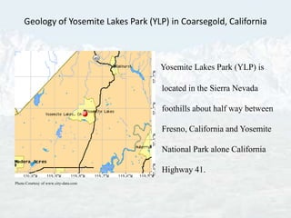
- 1. Geology of Yosemite Lakes Park (YLP) in Coarsegold, California Yosemite Lakes Park (YLP) is located in the Sierra Nevada foothills about half way between Fresno, California and Yosemite National Park alone California Highway 41. Photo Courtesy of www.city-data.com
- 2. The Sierra Nevada stretches for 400 miles along the eastern side of California. It is the longest and highest continuous mountain range in the lower forty-eight states. It is a well-pronounced asymmetrical mountain range with a steep east escapement and a gradual westward sloping side that extends into the broad San Joaquin Valley. A large normal system fault along the eastern edge of the Sierra Nevada, called the Sierra Nevada Fault, began to uplift about 25 million years ago at the end of the Oligocene epoch. The uplift was due to a major change in the motion of the North American plate. The Farallon oceanic plate, that was being subducted under what would become the Sierra Nevada Mountain Range, was totally consumed into the subduction zone (Huntington, 2001). Photo Courtesy of http://geoinfo.nmt.edu/tour/federal/monuments/gila_cliff_dwellings/farallon_plate.gif
- 3. Prior to the subduction of the Farallon oceanic plate, the Western North American Plate was dominated by the Cordilleran Foreland Fold and Thrust Belt (Constenius, 1996). The Pacific plate that moved into its place was moving in a different direction (northwest). The new boundary between the North American plate and the Pacific plate became a strike-slip fault system known today as the San Andreas. The change in motion from a convergent to a lateral movement produced a different stress on the Sierra Nevada region. Since the Sierra Nevada initial begin, the uplift has accelerated. It is estimated that the Sierra Nevada uplifts at a rate of 4 centimeters for every 100 years. The continental crust east of the region began to expand and the Sierra Nevada region began to rise. Below is a picture of the uplift and tilt of the Sierran Block with the east escarpment formed along the fault and the gently sloping western side (Huber, 1989). Photo Courtesy of http://www.yosemite.ca.us/library/geologic_story_of_yosemite/genesis.html
- 4. The Sierran Block is in the center of a highly active geological area. To the north is the very volcanically active Cascade Mountain range; to the south the Garlock Fault system running east to west; to the east is the Basin & Range province with many active fault systems such as Eastern California Shear Zone & Sierra Nevada Seismic Belt; and, of course, the world famous San Andreas Fault (Science Daily, 2005). Photo Courtesy of http://geology.csupomona.edu/docs/stop2-3.htm
- 5. The Sierran Block is a large batholith that forms the core of the Sierra Nevada Mountain Range. The batholith is composed of plutons that formed deep underground during a magma intrusion event many millions of years before the Sierra Block began to rise. The extremely hot more buoyant plutons called diapirs intruded through denser country rock and sediments, but never reaching the surface. Additionally during the magma intrusion, some magma reached the surface as lava flows, but most of it cooled and hardened below the surface and remained buried for millions of years. As the mountains rose, erosion wore down the material that had covered the batholith. The exposed portions are the familiar granite peaks of the Sierra Nevada mountain range, but most of the batholith remains below the surface (http://www.indiana.edu/~sierra/papers/2008/nahler.html). Photo Courtesy of http://www.geog.ucsb.edu/~joel/g148_f09/lecture_notes/sierra_nevada/sierra_batholith.gif
- 6. Half Dome Yosemite National Park Photo Courtesy of http://www.yosemitehikes.com/images/half-dome-winter-sunset-700w.jpg
- 7. Granite Granite comes from the Latin word "granum" (or grain) because of it granular texture. Sometimes members of this group are also called granitiods or quartz-feldspar-plutonic rocks. These are the most widely distributed plutonic rocks. Light colored mineral that is 20-60 % quartz, 40-80% feldspar and 0-20% dark minerals such as biotite, augite, hornblende, muscovite, apatite, zircon and/or magnetite. Feldspar, quartz and biotite (mica) are popularly considered to be the essential constituents of granite. Quartz is the second most abundant mineral in the Earth's continental crust is made up of a continuous framework of SiO4 silicon–oxygen tetrahedral, with each oxygen being shared between two tetrahedral, giving an overall formula SiO2. Feldspars , the most abundant mineral in the Earth’s continental crust (KAlSi3O8 - NaAlSi3O8 - CaAl2Si2O8) are a group of rock-forming tectosilicate minerals which make up as much as 60% of the Earth's crust. A mineral composed largely of linked chain of silica, aluminum and oxygen elements. Feldspar means "field crystal." Biotite is a common phyllosilicate mineral within the mica group, with the approximate chemical formula (Mg,Fe)3AlSi3O10(F,OH)2 (Schumann, 1993). http://www.granitebydesigns.com/images/products/1284025663Granite_Yosemite_P1160483.jpg
- 8. Granite of Yosemite Lakes Park, California On the left are three views of a same granite formation. Granite formation is located on Revis Mountain Photo Courtesy of Don Parker. Photo Courtesy of virtual.yosemite.cc.ca.us/ghayes/
- 9. SUMMARY Prior to the subduction of the Farallon oceanic plate, the Western North American Plate was dominated by the Cordilleran Foreland Fold and Thrust Belt. Sierra Nevada Uplift is due to the Farallon Plate subducting under the North American Plate. It is estimated that the Sierra Nevada uplifts at a rate of 4 centimeters for every 100 years. The Sierran Block is a large batholith that forms the core of the Sierra Nevada . The Sierra Batholith, containing plutonic rocks (igneous rock), ranging from granite to granodiorite to diorite. Sierra Nevada Mountain Range is dominated by exfoliating granite domes, i.e. Half Dome. Granite in YLP is composed of quartz, feldspar and biotite (mica).
- 10. References Constenius, K. N. (1996). Late Paleogene extensional collapse of the Cordilleran foreland fold and thrust belt. The Geological Society of America Bulletin , v. 108 no. 1 p. 20-39 . Editorial. (2005). Eastern California Shear Zone Puzzles Seismologists. http://www.sciencedaily.com/releases/2005/10/051019002624.htm: Science Daily. Huber, N. K. (1989). The Geologic Story of Yosemite National park. Yosemite National Park: Yosemite Association. Huntington, A. (2001). Yosemite National Park A Personal Discovery. Mariposa, California: Sierra Press. Nahler, N. (n.d.). Creation of the Sierra Nevada Batholith . http://www.indiana.edu/~sierra/papers/2008/nahler.html: Indiana University. Schumann, W. (1993). Handbook of Rocks, Minerals, And Gemstones. New York: HarperCollins Publishers and Houghton Mifflin Company.