Bhubaneswar Call Girls 8250077686 Service Offer VIP Hot Model
NostalgicOutdoors™- Buffalo National River- Lower district-hiking-trails
1. Horses are only allowed on the trails in•
the Lower Wilderness area.
Pets and mountain bikes are prohibited•
on all trails.
Use of all-terrain vehicles is prohibited•
anywhere in the park.
Pack out all trash.•
Leave things as you find them. Law pro-•
tects all plants, animals, rocks, historic
features, and archeological sites.
Mines are unstable. For your safety, do•
not enter.
Hunting is permitted in most areas of•
the park. State and federal regulations
apply.
This brochure includes popular hiking trails available in the lower district of the Buffalo National
River. Hikes lead to scenic vistas, historic places, and natural wonders. Trail difficulty varies,
ranging from easy to strenuous.
More detailed guides for the Indian Rockhouse and Rush trails are available at the Buffalo Point
Ranger Station. Topographical maps are strongly recommended for use on the Cow Creek-
Cook Hollow trail. Maps are available for sale in the park contact stations and local retail stores.
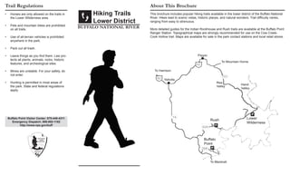
Hiking Trails
Lower District
buffalo national river
Trail Regulations About This Brochure
Buffalo Point Visitor Center: 870-449-4311
Emergency Dispatch: 888-692-1162
http://www.nps.gov/buff
2. Each year, hundreds of hikers walk the
scenic and rugged trails of Buffalo National
River. Most make it unassisted. A few, how-
ever, require a stretcher for the return trip.
Use caution and common sense to stay with
the majority. Consider the following when
planning your trip:
Let someone else know of your trip•
plans - where you are going and when
you will return.
Cliffs, unfenced overlooks, and uneven•
terrain exist throughout the park. Watch
for loose gravel, and keep an eye on
children.
Take extra water - one gallon per person•
per day is recommended. Water from
streams and springs is unsafe unless
treated.
Ticks can carry diseases that are pre-•
ventable. Check yourself after hiking.
Poisonous snakes and spiders are com-•
mon but rarely a problem.
Proper gear can save a life, maybe your•
own. Take a map, first-aid kit, matches,
compass, flashlight, and extra food.
Topographical maps, available at park•
contact stations and retails stores, are
recommended for extended day and
overnight hikes. Old roads that cross
hiking trails can be confusing.
For Your Protection Trail Descriptions
Area Trailhead Distance Hiking
Time
Features
Buffalo Point
Overlook Trail Buffalo Point Trailhead 0.3 mi (o)
0.5 km
1/2 hour Easy-moderate; spectacular view of river (a 0.4 mile
trail connects to campground trail from overlook)
Campground Trail Buffalo Point Trailhead 1.2 mi (o)
1.9 km
1/2 - 1 hour Strenuous; 360 foot elevation change; forested trail
Forest Trail Group Campground 0.7 mi (o)
1.1 km
1/2 hour Moderate-strenuous; forested trail, sinkhole
Indian Rockhouse Trail Buffalo Point Trailhead 3.5 mi (rt)
5.6 km
3 - 4 hours Strenuous; 380 foot elevation change; sinkhole, small
waterfall, small cave, bluff shelter with spring and un-
derground stream inside, water sculptured bedrock
Rush Area
Morning Star Loop Morning Star Parking Lot 0.3 mi (rt)
0.5 km
1/2 hour Moderate; historic mining area and structures
Rush Mountain Trail Morning Star Parking Lot 2.2 mi (o)
3.5 km
2 - 2 1/2
hours
Moderate-strenuous (high, steep, narrow trail); historic
mining structures and mines (entering mines prohibited)
Lower Wilderness
Cow Creek-Cook Hollow Trail Hathaway Hollow Trail-
head
10.5 mi (rt)
16.9 km
12 - 14 hours Very strenous; 680 foot elevation change (horses are
allowed on this trail); forested trail, river views, spring,
historic cemetery; topographical map is strongly recom-
mended when hiking or horseback riding in this area;
wear hunter orange in hunting season
* (rt) = roundtrip (o) = one way