SlideShare une entreprise Scribd logo
1  sur  2
ã2017 California Institute of Technology. Government sponsorship acknowledged.
NISAR: The NASA-ISRO SAR Mission
Monitoring Ground Movement Associated with Landslides
Landslides occur in soil or rock when the gravitational
force on a hillslope exceeds the strength of the rock or soil.
Most often this occurs in areas with steep slopes, during
or following heavy rainfall or snowmelt, and from shaking
due to earthquakes.
Landslide Hazards to
Infrastructure
Landslides and other geologic hazards kill dozens of people and cause
several billion dollars of damage every year in the United States. Landslides
can also cause significant environmental damage and societal disruption.
Landslides Can Move Slowly or Fail Catastrophically
Landslides and related slope movements can begin and move in a wide
variety of ways, depending on the geology, soil and ground-water conditions,
vegetation cover, and weather. Some landslides move at rates of a fraction
of an inch per year and can remain active for periods of decades or longer,
slowly causing damage to buildings, highways and other structures. Others
fail catastrophically and travel at rates of tens of miles per hour, causing loss
of infrastructure and life. Landslide sizes also vary greatly, from small shallow
slumps and slides that are only a couple yards across to large deep-seated
slides and flows that can reach lengths of several miles. Many landslides
move multiple times, so reactivation is often a concern.
Right: The La Conchita landslide that buried many houses in 2005, when a
pre-existing landslide was reactivated and rapidly moved downslope (from
USGS Open File Report 2005-1067).
The NISAR Mission – Reliable, Consistent Observations
The NASA–ISRO Synthetic Aperture Radar (NISAR) mission, a collaboration
between the National Aeronautics and Space Administration (NASA) and the
Indian Space Research Organization (ISRO), will provide all-weather,
day/night imaging of nearly the entire land and ice masses of the Earth
repeated 4-6 times per month. NISAR’s orbiting radars will image at
resolutions of 5-10 meters to identify and track subtle movement of the
Earth’s land and its sea ice, and even provide information about what is
happening below the surface. Its repeated set of high resolution images can
inform resource management and be used to detect small-scale changes
before they are visible to the eye. Products are expected to be available 1-2
days after observation, and within hours in response to disasters, providing
actionable, timely data for many applications.
.
ã2017 California Institute of Technology. Government sponsorship acknowledged.
Continued from front page
Landslides in the last few years have caused widespread
fatalities and major damage in the United States. During a
two-year period between 2014 and 2016, 61 people were
killed, including 43 in the Oso landslide in Washington
State (Coe, 2016). Globally, between 2000 and 3000
people are killed by landslides every year (Petley, 2017).
NISAR will be able to measure ground surface movement
directly through repeat imaging of landslide prone regions
and processing the sequence of images using synthetic
aperture radar interferometry (InSAR), which can
measure changes in the distance between the radar
antenna and the ground at the scale of a fraction of an
inch. One major advantage of InSAR is that it can be used
to measure surface deformation directly across large
areas (hundreds of miles) with far greater accuracy than is
possible with other commonly used remote sensing or
ground-based monitoring techniques (e.g., GPS
surveying). Radar has additional advantages over ground-
based and optical methods, the most significant of which
is the ability to see through clouds, smoke, and haze, and
the ability to image the ground surface during day or night
without relying on solar illumination.
All NISAR data products, including the products showing
surface movement, will be freely available through a web
portal. This way, the nation’s investment in land surveys
remotely acquired from space can be widely used by a
variety of agencies and individuals to detect landslide
movement when it begins to happen, and potentially
prevent further landslide movement from causing human
and economic disasters.
National Aeronautics and Space Administration For more information, visit http://nisar.jpl.nasa.gov/applications
Jet Propulsion Laboratory / California Institute of Technology / Pasadena, California / www.jpl.nasa.gov
Map showing areas of the conterminous
United States with negligible (gray) and some
(red) susceptibility to landslides [Modified
from Godt et al., 2012]
Some landslides move slowly over a long time, gradually damaging roads,
pipes, and other infrastructure. One example is shown at the right,
where ground movement of landslides in the Berkeley Hills of California
between 2008 and 2010 was captured using UAVSAR, NASA’s airborne
prototype for the NISAR space mission. In this type of map, called an
interferogram, the colors show contours of ground movement.
A regular schedule of radar imaging with NISAR, which will image all the
land in the United States and nearly all land globally, will enable
detection of slow-moving landslides, so damage can be avoided, and
potentially provide forewarning of rapid landslides in the weeks to
months prior to their catastrophic failure. As a result, these relatively
common and highly destructive geologic hazards will be identified more
quickly, efficiently, and economically, helping scientists, engineers, and
policy makers protect lives and property.
Monitoring Landslide Motion with Radar

Contenu connexe

Similaire à NISAR NASA-ISRO Synthetic Aperture Radar (NISAR) Landslides

NISAR NASA-ISRO Synthetic Aperture Radar (NISAR) Floods
NISAR NASA-ISRO Synthetic Aperture Radar (NISAR) FloodsNISAR NASA-ISRO Synthetic Aperture Radar (NISAR) Floods
NISAR NASA-ISRO Synthetic Aperture Radar (NISAR) FloodsDr. Pankaj Dhussa
 
NISAR NASA-ISRO Synthetic Aperture Radar (NISAR) Sinkholes and Cavern Collapse
NISAR NASA-ISRO Synthetic Aperture Radar (NISAR) Sinkholes and Cavern CollapseNISAR NASA-ISRO Synthetic Aperture Radar (NISAR) Sinkholes and Cavern Collapse
NISAR NASA-ISRO Synthetic Aperture Radar (NISAR) Sinkholes and Cavern CollapseDr. Pankaj Dhussa
 
NISAR NASA-ISRO Synthetic Aperture Radar (NISAR) Changes in Permafrost
NISAR NASA-ISRO Synthetic Aperture Radar (NISAR) Changes in PermafrostNISAR NASA-ISRO Synthetic Aperture Radar (NISAR) Changes in Permafrost
NISAR NASA-ISRO Synthetic Aperture Radar (NISAR) Changes in PermafrostDr. Pankaj Dhussa
 
NISAR NASA-ISRO Synthetic Aperture Radar (NISAR) Coastal Land Loss
NISAR NASA-ISRO Synthetic Aperture Radar (NISAR) Coastal Land LossNISAR NASA-ISRO Synthetic Aperture Radar (NISAR) Coastal Land Loss
NISAR NASA-ISRO Synthetic Aperture Radar (NISAR) Coastal Land LossDr. Pankaj Dhussa
 
NISAR NASA-ISRO Synthetic Aperture Radar (NISAR) Levees and Dams
NISAR NASA-ISRO Synthetic Aperture Radar (NISAR)  Levees and DamsNISAR NASA-ISRO Synthetic Aperture Radar (NISAR)  Levees and Dams
NISAR NASA-ISRO Synthetic Aperture Radar (NISAR) Levees and DamsDr. Pankaj Dhussa
 
NISAR NASA-ISRO Synthetic Aperture Radar (NISAR) Ice Sheets, Glaciers, and Oc...
NISAR NASA-ISRO Synthetic Aperture Radar (NISAR) Ice Sheets, Glaciers, and Oc...NISAR NASA-ISRO Synthetic Aperture Radar (NISAR) Ice Sheets, Glaciers, and Oc...
NISAR NASA-ISRO Synthetic Aperture Radar (NISAR) Ice Sheets, Glaciers, and Oc...Dr. Pankaj Dhussa
 
WE1.L09 - AN OVERVIEW OF THE DESDYNI MISSION
WE1.L09 - AN OVERVIEW OF THE DESDYNI MISSIONWE1.L09 - AN OVERVIEW OF THE DESDYNI MISSION
WE1.L09 - AN OVERVIEW OF THE DESDYNI MISSIONgrssieee
 
Seminar report on GPS based Space Debris Removal System
Seminar report on GPS based Space Debris Removal SystemSeminar report on GPS based Space Debris Removal System
Seminar report on GPS based Space Debris Removal SystemSunil Ds
 
Geomatics Based Landslide Vulnerability Zonation Mapping - Parts Of Nilgiri D...
Geomatics Based Landslide Vulnerability Zonation Mapping - Parts Of Nilgiri D...Geomatics Based Landslide Vulnerability Zonation Mapping - Parts Of Nilgiri D...
Geomatics Based Landslide Vulnerability Zonation Mapping - Parts Of Nilgiri D...IJERA Editor
 
NISAR NASA-ISRO Synthetic Aperture Radar (NISAR) Damage Mapping
NISAR NASA-ISRO Synthetic Aperture Radar (NISAR) Damage MappingNISAR NASA-ISRO Synthetic Aperture Radar (NISAR) Damage Mapping
NISAR NASA-ISRO Synthetic Aperture Radar (NISAR) Damage MappingDr. Pankaj Dhussa
 
NISAR NASA-ISRO Synthetic Aperture Radar (NISAR) Flood Forecasting
NISAR NASA-ISRO Synthetic Aperture Radar (NISAR)  Flood ForecastingNISAR NASA-ISRO Synthetic Aperture Radar (NISAR)  Flood Forecasting
NISAR NASA-ISRO Synthetic Aperture Radar (NISAR) Flood ForecastingDr. Pankaj Dhussa
 
Collins_et_al_-_Monitoring_shallow_landslides_in_SFB_California
Collins_et_al_-_Monitoring_shallow_landslides_in_SFB_CaliforniaCollins_et_al_-_Monitoring_shallow_landslides_in_SFB_California
Collins_et_al_-_Monitoring_shallow_landslides_in_SFB_CaliforniaMichael Walker Whitman
 
Watching earth from space
Watching earth from spaceWatching earth from space
Watching earth from spacebarrgrade2
 
NISAR ( NASA-ISRO Synthetic Aperture Radar (NISAR) ) Water
NISAR ( NASA-ISRO Synthetic Aperture Radar (NISAR) ) WaterNISAR ( NASA-ISRO Synthetic Aperture Radar (NISAR) ) Water
NISAR ( NASA-ISRO Synthetic Aperture Radar (NISAR) ) WaterDr. Pankaj Dhussa
 
Remote sensing in Disaster management
Remote sensing in Disaster managementRemote sensing in Disaster management
Remote sensing in Disaster managementDebasis Ray
 
Landslide Investigation of Ikwette, Obudu Local Government Area of Cross Rive...
Landslide Investigation of Ikwette, Obudu Local Government Area of Cross Rive...Landslide Investigation of Ikwette, Obudu Local Government Area of Cross Rive...
Landslide Investigation of Ikwette, Obudu Local Government Area of Cross Rive...iosrjce
 
gis in natural disaster management geo hazards
gis in natural disaster management  geo hazardsgis in natural disaster management  geo hazards
gis in natural disaster management geo hazardsSoumik Chakraborty
 

Similaire à NISAR NASA-ISRO Synthetic Aperture Radar (NISAR) Landslides (20)

NISAR NASA-ISRO Synthetic Aperture Radar (NISAR) Floods
NISAR NASA-ISRO Synthetic Aperture Radar (NISAR) FloodsNISAR NASA-ISRO Synthetic Aperture Radar (NISAR) Floods
NISAR NASA-ISRO Synthetic Aperture Radar (NISAR) Floods
 
NISAR NASA-ISRO Synthetic Aperture Radar (NISAR) Sinkholes and Cavern Collapse
NISAR NASA-ISRO Synthetic Aperture Radar (NISAR) Sinkholes and Cavern CollapseNISAR NASA-ISRO Synthetic Aperture Radar (NISAR) Sinkholes and Cavern Collapse
NISAR NASA-ISRO Synthetic Aperture Radar (NISAR) Sinkholes and Cavern Collapse
 
NISAR NASA-ISRO Synthetic Aperture Radar (NISAR) Changes in Permafrost
NISAR NASA-ISRO Synthetic Aperture Radar (NISAR) Changes in PermafrostNISAR NASA-ISRO Synthetic Aperture Radar (NISAR) Changes in Permafrost
NISAR NASA-ISRO Synthetic Aperture Radar (NISAR) Changes in Permafrost
 
NASA EarthDay 2023
NASA EarthDay 2023NASA EarthDay 2023
NASA EarthDay 2023
 
Discover the world around you.
Discover the world around you.Discover the world around you.
Discover the world around you.
 
NISAR NASA-ISRO Synthetic Aperture Radar (NISAR) Coastal Land Loss
NISAR NASA-ISRO Synthetic Aperture Radar (NISAR) Coastal Land LossNISAR NASA-ISRO Synthetic Aperture Radar (NISAR) Coastal Land Loss
NISAR NASA-ISRO Synthetic Aperture Radar (NISAR) Coastal Land Loss
 
NISAR NASA-ISRO Synthetic Aperture Radar (NISAR) Levees and Dams
NISAR NASA-ISRO Synthetic Aperture Radar (NISAR)  Levees and DamsNISAR NASA-ISRO Synthetic Aperture Radar (NISAR)  Levees and Dams
NISAR NASA-ISRO Synthetic Aperture Radar (NISAR) Levees and Dams
 
NISAR NASA-ISRO Synthetic Aperture Radar (NISAR) Ice Sheets, Glaciers, and Oc...
NISAR NASA-ISRO Synthetic Aperture Radar (NISAR) Ice Sheets, Glaciers, and Oc...NISAR NASA-ISRO Synthetic Aperture Radar (NISAR) Ice Sheets, Glaciers, and Oc...
NISAR NASA-ISRO Synthetic Aperture Radar (NISAR) Ice Sheets, Glaciers, and Oc...
 
WE1.L09 - AN OVERVIEW OF THE DESDYNI MISSION
WE1.L09 - AN OVERVIEW OF THE DESDYNI MISSIONWE1.L09 - AN OVERVIEW OF THE DESDYNI MISSION
WE1.L09 - AN OVERVIEW OF THE DESDYNI MISSION
 
Seminar report on GPS based Space Debris Removal System
Seminar report on GPS based Space Debris Removal SystemSeminar report on GPS based Space Debris Removal System
Seminar report on GPS based Space Debris Removal System
 
Geomatics Based Landslide Vulnerability Zonation Mapping - Parts Of Nilgiri D...
Geomatics Based Landslide Vulnerability Zonation Mapping - Parts Of Nilgiri D...Geomatics Based Landslide Vulnerability Zonation Mapping - Parts Of Nilgiri D...
Geomatics Based Landslide Vulnerability Zonation Mapping - Parts Of Nilgiri D...
 
NASA Keynote Presentation - Monday Conservation Forum
NASA Keynote Presentation - Monday Conservation ForumNASA Keynote Presentation - Monday Conservation Forum
NASA Keynote Presentation - Monday Conservation Forum
 
NISAR NASA-ISRO Synthetic Aperture Radar (NISAR) Damage Mapping
NISAR NASA-ISRO Synthetic Aperture Radar (NISAR) Damage MappingNISAR NASA-ISRO Synthetic Aperture Radar (NISAR) Damage Mapping
NISAR NASA-ISRO Synthetic Aperture Radar (NISAR) Damage Mapping
 
NISAR NASA-ISRO Synthetic Aperture Radar (NISAR) Flood Forecasting
NISAR NASA-ISRO Synthetic Aperture Radar (NISAR)  Flood ForecastingNISAR NASA-ISRO Synthetic Aperture Radar (NISAR)  Flood Forecasting
NISAR NASA-ISRO Synthetic Aperture Radar (NISAR) Flood Forecasting
 
Collins_et_al_-_Monitoring_shallow_landslides_in_SFB_California
Collins_et_al_-_Monitoring_shallow_landslides_in_SFB_CaliforniaCollins_et_al_-_Monitoring_shallow_landslides_in_SFB_California
Collins_et_al_-_Monitoring_shallow_landslides_in_SFB_California
 
Watching earth from space
Watching earth from spaceWatching earth from space
Watching earth from space
 
NISAR ( NASA-ISRO Synthetic Aperture Radar (NISAR) ) Water
NISAR ( NASA-ISRO Synthetic Aperture Radar (NISAR) ) WaterNISAR ( NASA-ISRO Synthetic Aperture Radar (NISAR) ) Water
NISAR ( NASA-ISRO Synthetic Aperture Radar (NISAR) ) Water
 
Remote sensing in Disaster management
Remote sensing in Disaster managementRemote sensing in Disaster management
Remote sensing in Disaster management
 
Landslide Investigation of Ikwette, Obudu Local Government Area of Cross Rive...
Landslide Investigation of Ikwette, Obudu Local Government Area of Cross Rive...Landslide Investigation of Ikwette, Obudu Local Government Area of Cross Rive...
Landslide Investigation of Ikwette, Obudu Local Government Area of Cross Rive...
 
gis in natural disaster management geo hazards
gis in natural disaster management  geo hazardsgis in natural disaster management  geo hazards
gis in natural disaster management geo hazards
 

Plus de Dr. Pankaj Dhussa

NASA Public Perception: Community Response to X-59 Quesst Mission: Phase 3
NASA Public Perception: Community Response to X-59 Quesst Mission: Phase 3NASA Public Perception: Community Response to X-59 Quesst Mission: Phase 3
NASA Public Perception: Community Response to X-59 Quesst Mission: Phase 3Dr. Pankaj Dhussa
 
NASA Overcoming the 50-Year Ban History of the Ban on Commercial Supersonic F...
NASA Overcoming the 50-Year Ban History of the Ban on Commercial Supersonic F...NASA Overcoming the 50-Year Ban History of the Ban on Commercial Supersonic F...
NASA Overcoming the 50-Year Ban History of the Ban on Commercial Supersonic F...Dr. Pankaj Dhussa
 
NASA Flight Demonstration and Capabilities Quesst Phase 3 Flight Operations
NASA Flight Demonstration and Capabilities Quesst Phase 3 Flight OperationsNASA Flight Demonstration and Capabilities Quesst Phase 3 Flight Operations
NASA Flight Demonstration and Capabilities Quesst Phase 3 Flight OperationsDr. Pankaj Dhussa
 
NASA Carbon Fiber Composites (CFC) Recycling Technology Enabled by the TuFF T...
NASA Carbon Fiber Composites (CFC) Recycling Technology Enabled by the TuFF T...NASA Carbon Fiber Composites (CFC) Recycling Technology Enabled by the TuFF T...
NASA Carbon Fiber Composites (CFC) Recycling Technology Enabled by the TuFF T...Dr. Pankaj Dhussa
 
NASA Urban Air Mobility Fatigue Prediction Aaron Crawford – NASA ULI Innovati...
NASA Urban Air Mobility Fatigue Prediction Aaron Crawford – NASA ULI Innovati...NASA Urban Air Mobility Fatigue Prediction Aaron Crawford – NASA ULI Innovati...
NASA Urban Air Mobility Fatigue Prediction Aaron Crawford – NASA ULI Innovati...Dr. Pankaj Dhussa
 
NASA Automated Repair Approaches for AAM
NASA Automated Repair Approaches for AAMNASA Automated Repair Approaches for AAM
NASA Automated Repair Approaches for AAMDr. Pankaj Dhussa
 
NASA Multiscale Analysis Tool (NASMAT) Robust, Integrated, Physics-based, Non...
NASA Multiscale Analysis Tool (NASMAT) Robust, Integrated, Physics-based, Non...NASA Multiscale Analysis Tool (NASMAT) Robust, Integrated, Physics-based, Non...
NASA Multiscale Analysis Tool (NASMAT) Robust, Integrated, Physics-based, Non...Dr. Pankaj Dhussa
 
NASA Materials Informatics Enables Rapid Materials Discovery
NASA Materials Informatics Enables Rapid Materials DiscoveryNASA Materials Informatics Enables Rapid Materials Discovery
NASA Materials Informatics Enables Rapid Materials DiscoveryDr. Pankaj Dhussa
 
NASA CFD Vision 2030: The Power of Exascale Computing
NASA CFD Vision 2030: The Power of Exascale ComputingNASA CFD Vision 2030: The Power of Exascale Computing
NASA CFD Vision 2030: The Power of Exascale ComputingDr. Pankaj Dhussa
 
NASA High Lift Common Research Model (CRM-HL) Ecosystem
NASA High Lift Common Research Model (CRM-HL) EcosystemNASA High Lift Common Research Model (CRM-HL) Ecosystem
NASA High Lift Common Research Model (CRM-HL) EcosystemDr. Pankaj Dhussa
 
NASA Aviary Open-source software tool for optimizing next-generation aircraft...
NASA Aviary Open-source software tool for optimizing next-generation aircraft...NASA Aviary Open-source software tool for optimizing next-generation aircraft...
NASA Aviary Open-source software tool for optimizing next-generation aircraft...Dr. Pankaj Dhussa
 
NASA Aircraft Certification by Analysis (CbA) 20-year Vision for Virtual Flig...
NASA Aircraft Certification by Analysis (CbA) 20-year Vision for Virtual Flig...NASA Aircraft Certification by Analysis (CbA) 20-year Vision for Virtual Flig...
NASA Aircraft Certification by Analysis (CbA) 20-year Vision for Virtual Flig...Dr. Pankaj Dhussa
 
NASA Self-Aligned Focusing Schlieren (SAFS) Flow Visualization Technique
NASA Self-Aligned Focusing Schlieren (SAFS) Flow Visualization TechniqueNASA Self-Aligned Focusing Schlieren (SAFS) Flow Visualization Technique
NASA Self-Aligned Focusing Schlieren (SAFS) Flow Visualization TechniqueDr. Pankaj Dhussa
 
NASA DECO CAS Research into a New Operating Mode for Digitally Enabled Cooper...
NASA DECO CAS Research into a New Operating Mode for Digitally Enabled Cooper...NASA DECO CAS Research into a New Operating Mode for Digitally Enabled Cooper...
NASA DECO CAS Research into a New Operating Mode for Digitally Enabled Cooper...Dr. Pankaj Dhussa
 
NASA Advanced Exploration of Reliable Operation at low Altitudes: meteorology...
NASA Advanced Exploration of Reliable Operation at low Altitudes: meteorology...NASA Advanced Exploration of Reliable Operation at low Altitudes: meteorology...
NASA Advanced Exploration of Reliable Operation at low Altitudes: meteorology...Dr. Pankaj Dhussa
 
NASA Self-Adaptation of Loosely Coupled Systems across a System of Small Uncr...
NASA Self-Adaptation of Loosely Coupled Systems across a System of Small Uncr...NASA Self-Adaptation of Loosely Coupled Systems across a System of Small Uncr...
NASA Self-Adaptation of Loosely Coupled Systems across a System of Small Uncr...Dr. Pankaj Dhussa
 
NASA Safety Case Approach for Automated Flight Authorization System
NASA Safety Case Approach for Automated Flight Authorization SystemNASA Safety Case Approach for Automated Flight Authorization System
NASA Safety Case Approach for Automated Flight Authorization SystemDr. Pankaj Dhussa
 
NASA RealWindDroneSim (RWDS) Enhancing Simulation Fidelity of small Uncrewed ...
NASA RealWindDroneSim (RWDS) Enhancing Simulation Fidelity of small Uncrewed ...NASA RealWindDroneSim (RWDS) Enhancing Simulation Fidelity of small Uncrewed ...
NASA RealWindDroneSim (RWDS) Enhancing Simulation Fidelity of small Uncrewed ...Dr. Pankaj Dhussa
 
NASA ARMD Test Data Portal (ATDP) Agile Development Method Introduction of an...
NASA ARMD Test Data Portal (ATDP) Agile Development Method Introduction of an...NASA ARMD Test Data Portal (ATDP) Agile Development Method Introduction of an...
NASA ARMD Test Data Portal (ATDP) Agile Development Method Introduction of an...Dr. Pankaj Dhussa
 
NASA ARMD Test Data Portal (ATDP) he ARMD Test Data Portal (ATDP) is a secure...
NASA ARMD Test Data Portal (ATDP) he ARMD Test Data Portal (ATDP) is a secure...NASA ARMD Test Data Portal (ATDP) he ARMD Test Data Portal (ATDP) is a secure...
NASA ARMD Test Data Portal (ATDP) he ARMD Test Data Portal (ATDP) is a secure...Dr. Pankaj Dhussa
 

Plus de Dr. Pankaj Dhussa (20)

NASA Public Perception: Community Response to X-59 Quesst Mission: Phase 3
NASA Public Perception: Community Response to X-59 Quesst Mission: Phase 3NASA Public Perception: Community Response to X-59 Quesst Mission: Phase 3
NASA Public Perception: Community Response to X-59 Quesst Mission: Phase 3
 
NASA Overcoming the 50-Year Ban History of the Ban on Commercial Supersonic F...
NASA Overcoming the 50-Year Ban History of the Ban on Commercial Supersonic F...NASA Overcoming the 50-Year Ban History of the Ban on Commercial Supersonic F...
NASA Overcoming the 50-Year Ban History of the Ban on Commercial Supersonic F...
 
NASA Flight Demonstration and Capabilities Quesst Phase 3 Flight Operations
NASA Flight Demonstration and Capabilities Quesst Phase 3 Flight OperationsNASA Flight Demonstration and Capabilities Quesst Phase 3 Flight Operations
NASA Flight Demonstration and Capabilities Quesst Phase 3 Flight Operations
 
NASA Carbon Fiber Composites (CFC) Recycling Technology Enabled by the TuFF T...
NASA Carbon Fiber Composites (CFC) Recycling Technology Enabled by the TuFF T...NASA Carbon Fiber Composites (CFC) Recycling Technology Enabled by the TuFF T...
NASA Carbon Fiber Composites (CFC) Recycling Technology Enabled by the TuFF T...
 
NASA Urban Air Mobility Fatigue Prediction Aaron Crawford – NASA ULI Innovati...
NASA Urban Air Mobility Fatigue Prediction Aaron Crawford – NASA ULI Innovati...NASA Urban Air Mobility Fatigue Prediction Aaron Crawford – NASA ULI Innovati...
NASA Urban Air Mobility Fatigue Prediction Aaron Crawford – NASA ULI Innovati...
 
NASA Automated Repair Approaches for AAM
NASA Automated Repair Approaches for AAMNASA Automated Repair Approaches for AAM
NASA Automated Repair Approaches for AAM
 
NASA Multiscale Analysis Tool (NASMAT) Robust, Integrated, Physics-based, Non...
NASA Multiscale Analysis Tool (NASMAT) Robust, Integrated, Physics-based, Non...NASA Multiscale Analysis Tool (NASMAT) Robust, Integrated, Physics-based, Non...
NASA Multiscale Analysis Tool (NASMAT) Robust, Integrated, Physics-based, Non...
 
NASA Materials Informatics Enables Rapid Materials Discovery
NASA Materials Informatics Enables Rapid Materials DiscoveryNASA Materials Informatics Enables Rapid Materials Discovery
NASA Materials Informatics Enables Rapid Materials Discovery
 
NASA CFD Vision 2030: The Power of Exascale Computing
NASA CFD Vision 2030: The Power of Exascale ComputingNASA CFD Vision 2030: The Power of Exascale Computing
NASA CFD Vision 2030: The Power of Exascale Computing
 
NASA High Lift Common Research Model (CRM-HL) Ecosystem
NASA High Lift Common Research Model (CRM-HL) EcosystemNASA High Lift Common Research Model (CRM-HL) Ecosystem
NASA High Lift Common Research Model (CRM-HL) Ecosystem
 
NASA Aviary Open-source software tool for optimizing next-generation aircraft...
NASA Aviary Open-source software tool for optimizing next-generation aircraft...NASA Aviary Open-source software tool for optimizing next-generation aircraft...
NASA Aviary Open-source software tool for optimizing next-generation aircraft...
 
NASA Aircraft Certification by Analysis (CbA) 20-year Vision for Virtual Flig...
NASA Aircraft Certification by Analysis (CbA) 20-year Vision for Virtual Flig...NASA Aircraft Certification by Analysis (CbA) 20-year Vision for Virtual Flig...
NASA Aircraft Certification by Analysis (CbA) 20-year Vision for Virtual Flig...
 
NASA Self-Aligned Focusing Schlieren (SAFS) Flow Visualization Technique
NASA Self-Aligned Focusing Schlieren (SAFS) Flow Visualization TechniqueNASA Self-Aligned Focusing Schlieren (SAFS) Flow Visualization Technique
NASA Self-Aligned Focusing Schlieren (SAFS) Flow Visualization Technique
 
NASA DECO CAS Research into a New Operating Mode for Digitally Enabled Cooper...
NASA DECO CAS Research into a New Operating Mode for Digitally Enabled Cooper...NASA DECO CAS Research into a New Operating Mode for Digitally Enabled Cooper...
NASA DECO CAS Research into a New Operating Mode for Digitally Enabled Cooper...
 
NASA Advanced Exploration of Reliable Operation at low Altitudes: meteorology...
NASA Advanced Exploration of Reliable Operation at low Altitudes: meteorology...NASA Advanced Exploration of Reliable Operation at low Altitudes: meteorology...
NASA Advanced Exploration of Reliable Operation at low Altitudes: meteorology...
 
NASA Self-Adaptation of Loosely Coupled Systems across a System of Small Uncr...
NASA Self-Adaptation of Loosely Coupled Systems across a System of Small Uncr...NASA Self-Adaptation of Loosely Coupled Systems across a System of Small Uncr...
NASA Self-Adaptation of Loosely Coupled Systems across a System of Small Uncr...
 
NASA Safety Case Approach for Automated Flight Authorization System
NASA Safety Case Approach for Automated Flight Authorization SystemNASA Safety Case Approach for Automated Flight Authorization System
NASA Safety Case Approach for Automated Flight Authorization System
 
NASA RealWindDroneSim (RWDS) Enhancing Simulation Fidelity of small Uncrewed ...
NASA RealWindDroneSim (RWDS) Enhancing Simulation Fidelity of small Uncrewed ...NASA RealWindDroneSim (RWDS) Enhancing Simulation Fidelity of small Uncrewed ...
NASA RealWindDroneSim (RWDS) Enhancing Simulation Fidelity of small Uncrewed ...
 
NASA ARMD Test Data Portal (ATDP) Agile Development Method Introduction of an...
NASA ARMD Test Data Portal (ATDP) Agile Development Method Introduction of an...NASA ARMD Test Data Portal (ATDP) Agile Development Method Introduction of an...
NASA ARMD Test Data Portal (ATDP) Agile Development Method Introduction of an...
 
NASA ARMD Test Data Portal (ATDP) he ARMD Test Data Portal (ATDP) is a secure...
NASA ARMD Test Data Portal (ATDP) he ARMD Test Data Portal (ATDP) is a secure...NASA ARMD Test Data Portal (ATDP) he ARMD Test Data Portal (ATDP) is a secure...
NASA ARMD Test Data Portal (ATDP) he ARMD Test Data Portal (ATDP) is a secure...
 

Dernier

ProductAnonymous-April2024-WinProductDiscovery-MelissaKlemke
ProductAnonymous-April2024-WinProductDiscovery-MelissaKlemkeProductAnonymous-April2024-WinProductDiscovery-MelissaKlemke
ProductAnonymous-April2024-WinProductDiscovery-MelissaKlemkeProduct Anonymous
 
Cloud Frontiers: A Deep Dive into Serverless Spatial Data and FME
Cloud Frontiers:  A Deep Dive into Serverless Spatial Data and FMECloud Frontiers:  A Deep Dive into Serverless Spatial Data and FME
Cloud Frontiers: A Deep Dive into Serverless Spatial Data and FMESafe Software
 
Why Teams call analytics are critical to your entire business
Why Teams call analytics are critical to your entire businessWhy Teams call analytics are critical to your entire business
Why Teams call analytics are critical to your entire businesspanagenda
 
Platformless Horizons for Digital Adaptability
Platformless Horizons for Digital AdaptabilityPlatformless Horizons for Digital Adaptability
Platformless Horizons for Digital AdaptabilityWSO2
 
TrustArc Webinar - Unlock the Power of AI-Driven Data Discovery
TrustArc Webinar - Unlock the Power of AI-Driven Data DiscoveryTrustArc Webinar - Unlock the Power of AI-Driven Data Discovery
TrustArc Webinar - Unlock the Power of AI-Driven Data DiscoveryTrustArc
 
Cloud Frontiers: A Deep Dive into Serverless Spatial Data and FME
Cloud Frontiers:  A Deep Dive into Serverless Spatial Data and FMECloud Frontiers:  A Deep Dive into Serverless Spatial Data and FME
Cloud Frontiers: A Deep Dive into Serverless Spatial Data and FMESafe Software
 
WSO2's API Vision: Unifying Control, Empowering Developers
WSO2's API Vision: Unifying Control, Empowering DevelopersWSO2's API Vision: Unifying Control, Empowering Developers
WSO2's API Vision: Unifying Control, Empowering DevelopersWSO2
 
Finding Java's Hidden Performance Traps @ DevoxxUK 2024
Finding Java's Hidden Performance Traps @ DevoxxUK 2024Finding Java's Hidden Performance Traps @ DevoxxUK 2024
Finding Java's Hidden Performance Traps @ DevoxxUK 2024Victor Rentea
 
Apidays New York 2024 - APIs in 2030: The Risk of Technological Sleepwalk by ...
Apidays New York 2024 - APIs in 2030: The Risk of Technological Sleepwalk by ...Apidays New York 2024 - APIs in 2030: The Risk of Technological Sleepwalk by ...
Apidays New York 2024 - APIs in 2030: The Risk of Technological Sleepwalk by ...apidays
 
Navigating the Deluge_ Dubai Floods and the Resilience of Dubai International...
Navigating the Deluge_ Dubai Floods and the Resilience of Dubai International...Navigating the Deluge_ Dubai Floods and the Resilience of Dubai International...
Navigating the Deluge_ Dubai Floods and the Resilience of Dubai International...Orbitshub
 
Architecting Cloud Native Applications
Architecting Cloud Native ApplicationsArchitecting Cloud Native Applications
Architecting Cloud Native ApplicationsWSO2
 
Apidays New York 2024 - Passkeys: Developing APIs to enable passwordless auth...
Apidays New York 2024 - Passkeys: Developing APIs to enable passwordless auth...Apidays New York 2024 - Passkeys: Developing APIs to enable passwordless auth...
Apidays New York 2024 - Passkeys: Developing APIs to enable passwordless auth...apidays
 
Apidays New York 2024 - The value of a flexible API Management solution for O...
Apidays New York 2024 - The value of a flexible API Management solution for O...Apidays New York 2024 - The value of a flexible API Management solution for O...
Apidays New York 2024 - The value of a flexible API Management solution for O...apidays
 
DEV meet-up UiPath Document Understanding May 7 2024 Amsterdam
DEV meet-up UiPath Document Understanding May 7 2024 AmsterdamDEV meet-up UiPath Document Understanding May 7 2024 Amsterdam
DEV meet-up UiPath Document Understanding May 7 2024 AmsterdamUiPathCommunity
 
Biography Of Angeliki Cooney | Senior Vice President Life Sciences | Albany, ...
Biography Of Angeliki Cooney | Senior Vice President Life Sciences | Albany, ...Biography Of Angeliki Cooney | Senior Vice President Life Sciences | Albany, ...
Biography Of Angeliki Cooney | Senior Vice President Life Sciences | Albany, ...Angeliki Cooney
 
Strategies for Landing an Oracle DBA Job as a Fresher
Strategies for Landing an Oracle DBA Job as a FresherStrategies for Landing an Oracle DBA Job as a Fresher
Strategies for Landing an Oracle DBA Job as a FresherRemote DBA Services
 
ICT role in 21st century education and its challenges
ICT role in 21st century education and its challengesICT role in 21st century education and its challenges
ICT role in 21st century education and its challengesrafiqahmad00786416
 
DBX First Quarter 2024 Investor Presentation
DBX First Quarter 2024 Investor PresentationDBX First Quarter 2024 Investor Presentation
DBX First Quarter 2024 Investor PresentationDropbox
 
Web Form Automation for Bonterra Impact Management (fka Social Solutions Apri...
Web Form Automation for Bonterra Impact Management (fka Social Solutions Apri...Web Form Automation for Bonterra Impact Management (fka Social Solutions Apri...
Web Form Automation for Bonterra Impact Management (fka Social Solutions Apri...Jeffrey Haguewood
 
Artificial Intelligence Chap.5 : Uncertainty
Artificial Intelligence Chap.5 : UncertaintyArtificial Intelligence Chap.5 : Uncertainty
Artificial Intelligence Chap.5 : UncertaintyKhushali Kathiriya
 

Dernier (20)

ProductAnonymous-April2024-WinProductDiscovery-MelissaKlemke
ProductAnonymous-April2024-WinProductDiscovery-MelissaKlemkeProductAnonymous-April2024-WinProductDiscovery-MelissaKlemke
ProductAnonymous-April2024-WinProductDiscovery-MelissaKlemke
 
Cloud Frontiers: A Deep Dive into Serverless Spatial Data and FME
Cloud Frontiers:  A Deep Dive into Serverless Spatial Data and FMECloud Frontiers:  A Deep Dive into Serverless Spatial Data and FME
Cloud Frontiers: A Deep Dive into Serverless Spatial Data and FME
 
Why Teams call analytics are critical to your entire business
Why Teams call analytics are critical to your entire businessWhy Teams call analytics are critical to your entire business
Why Teams call analytics are critical to your entire business
 
Platformless Horizons for Digital Adaptability
Platformless Horizons for Digital AdaptabilityPlatformless Horizons for Digital Adaptability
Platformless Horizons for Digital Adaptability
 
TrustArc Webinar - Unlock the Power of AI-Driven Data Discovery
TrustArc Webinar - Unlock the Power of AI-Driven Data DiscoveryTrustArc Webinar - Unlock the Power of AI-Driven Data Discovery
TrustArc Webinar - Unlock the Power of AI-Driven Data Discovery
 
Cloud Frontiers: A Deep Dive into Serverless Spatial Data and FME
Cloud Frontiers:  A Deep Dive into Serverless Spatial Data and FMECloud Frontiers:  A Deep Dive into Serverless Spatial Data and FME
Cloud Frontiers: A Deep Dive into Serverless Spatial Data and FME
 
WSO2's API Vision: Unifying Control, Empowering Developers
WSO2's API Vision: Unifying Control, Empowering DevelopersWSO2's API Vision: Unifying Control, Empowering Developers
WSO2's API Vision: Unifying Control, Empowering Developers
 
Finding Java's Hidden Performance Traps @ DevoxxUK 2024
Finding Java's Hidden Performance Traps @ DevoxxUK 2024Finding Java's Hidden Performance Traps @ DevoxxUK 2024
Finding Java's Hidden Performance Traps @ DevoxxUK 2024
 
Apidays New York 2024 - APIs in 2030: The Risk of Technological Sleepwalk by ...
Apidays New York 2024 - APIs in 2030: The Risk of Technological Sleepwalk by ...Apidays New York 2024 - APIs in 2030: The Risk of Technological Sleepwalk by ...
Apidays New York 2024 - APIs in 2030: The Risk of Technological Sleepwalk by ...
 
Navigating the Deluge_ Dubai Floods and the Resilience of Dubai International...
Navigating the Deluge_ Dubai Floods and the Resilience of Dubai International...Navigating the Deluge_ Dubai Floods and the Resilience of Dubai International...
Navigating the Deluge_ Dubai Floods and the Resilience of Dubai International...
 
Architecting Cloud Native Applications
Architecting Cloud Native ApplicationsArchitecting Cloud Native Applications
Architecting Cloud Native Applications
 
Apidays New York 2024 - Passkeys: Developing APIs to enable passwordless auth...
Apidays New York 2024 - Passkeys: Developing APIs to enable passwordless auth...Apidays New York 2024 - Passkeys: Developing APIs to enable passwordless auth...
Apidays New York 2024 - Passkeys: Developing APIs to enable passwordless auth...
 
Apidays New York 2024 - The value of a flexible API Management solution for O...
Apidays New York 2024 - The value of a flexible API Management solution for O...Apidays New York 2024 - The value of a flexible API Management solution for O...
Apidays New York 2024 - The value of a flexible API Management solution for O...
 
DEV meet-up UiPath Document Understanding May 7 2024 Amsterdam
DEV meet-up UiPath Document Understanding May 7 2024 AmsterdamDEV meet-up UiPath Document Understanding May 7 2024 Amsterdam
DEV meet-up UiPath Document Understanding May 7 2024 Amsterdam
 
Biography Of Angeliki Cooney | Senior Vice President Life Sciences | Albany, ...
Biography Of Angeliki Cooney | Senior Vice President Life Sciences | Albany, ...Biography Of Angeliki Cooney | Senior Vice President Life Sciences | Albany, ...
Biography Of Angeliki Cooney | Senior Vice President Life Sciences | Albany, ...
 
Strategies for Landing an Oracle DBA Job as a Fresher
Strategies for Landing an Oracle DBA Job as a FresherStrategies for Landing an Oracle DBA Job as a Fresher
Strategies for Landing an Oracle DBA Job as a Fresher
 
ICT role in 21st century education and its challenges
ICT role in 21st century education and its challengesICT role in 21st century education and its challenges
ICT role in 21st century education and its challenges
 
DBX First Quarter 2024 Investor Presentation
DBX First Quarter 2024 Investor PresentationDBX First Quarter 2024 Investor Presentation
DBX First Quarter 2024 Investor Presentation
 
Web Form Automation for Bonterra Impact Management (fka Social Solutions Apri...
Web Form Automation for Bonterra Impact Management (fka Social Solutions Apri...Web Form Automation for Bonterra Impact Management (fka Social Solutions Apri...
Web Form Automation for Bonterra Impact Management (fka Social Solutions Apri...
 
Artificial Intelligence Chap.5 : Uncertainty
Artificial Intelligence Chap.5 : UncertaintyArtificial Intelligence Chap.5 : Uncertainty
Artificial Intelligence Chap.5 : Uncertainty
 

NISAR NASA-ISRO Synthetic Aperture Radar (NISAR) Landslides

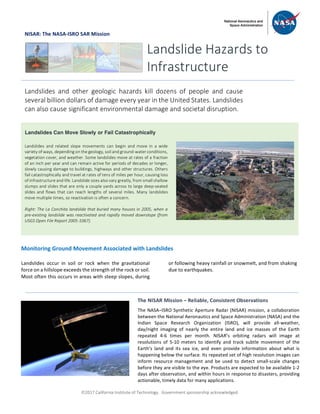
  • 1. ã2017 California Institute of Technology. Government sponsorship acknowledged. NISAR: The NASA-ISRO SAR Mission Monitoring Ground Movement Associated with Landslides Landslides occur in soil or rock when the gravitational force on a hillslope exceeds the strength of the rock or soil. Most often this occurs in areas with steep slopes, during or following heavy rainfall or snowmelt, and from shaking due to earthquakes. Landslide Hazards to Infrastructure Landslides and other geologic hazards kill dozens of people and cause several billion dollars of damage every year in the United States. Landslides can also cause significant environmental damage and societal disruption. Landslides Can Move Slowly or Fail Catastrophically Landslides and related slope movements can begin and move in a wide variety of ways, depending on the geology, soil and ground-water conditions, vegetation cover, and weather. Some landslides move at rates of a fraction of an inch per year and can remain active for periods of decades or longer, slowly causing damage to buildings, highways and other structures. Others fail catastrophically and travel at rates of tens of miles per hour, causing loss of infrastructure and life. Landslide sizes also vary greatly, from small shallow slumps and slides that are only a couple yards across to large deep-seated slides and flows that can reach lengths of several miles. Many landslides move multiple times, so reactivation is often a concern. Right: The La Conchita landslide that buried many houses in 2005, when a pre-existing landslide was reactivated and rapidly moved downslope (from USGS Open File Report 2005-1067). The NISAR Mission – Reliable, Consistent Observations The NASA–ISRO Synthetic Aperture Radar (NISAR) mission, a collaboration between the National Aeronautics and Space Administration (NASA) and the Indian Space Research Organization (ISRO), will provide all-weather, day/night imaging of nearly the entire land and ice masses of the Earth repeated 4-6 times per month. NISAR’s orbiting radars will image at resolutions of 5-10 meters to identify and track subtle movement of the Earth’s land and its sea ice, and even provide information about what is happening below the surface. Its repeated set of high resolution images can inform resource management and be used to detect small-scale changes before they are visible to the eye. Products are expected to be available 1-2 days after observation, and within hours in response to disasters, providing actionable, timely data for many applications. .
  • 2. ã2017 California Institute of Technology. Government sponsorship acknowledged. Continued from front page Landslides in the last few years have caused widespread fatalities and major damage in the United States. During a two-year period between 2014 and 2016, 61 people were killed, including 43 in the Oso landslide in Washington State (Coe, 2016). Globally, between 2000 and 3000 people are killed by landslides every year (Petley, 2017). NISAR will be able to measure ground surface movement directly through repeat imaging of landslide prone regions and processing the sequence of images using synthetic aperture radar interferometry (InSAR), which can measure changes in the distance between the radar antenna and the ground at the scale of a fraction of an inch. One major advantage of InSAR is that it can be used to measure surface deformation directly across large areas (hundreds of miles) with far greater accuracy than is possible with other commonly used remote sensing or ground-based monitoring techniques (e.g., GPS surveying). Radar has additional advantages over ground- based and optical methods, the most significant of which is the ability to see through clouds, smoke, and haze, and the ability to image the ground surface during day or night without relying on solar illumination. All NISAR data products, including the products showing surface movement, will be freely available through a web portal. This way, the nation’s investment in land surveys remotely acquired from space can be widely used by a variety of agencies and individuals to detect landslide movement when it begins to happen, and potentially prevent further landslide movement from causing human and economic disasters. National Aeronautics and Space Administration For more information, visit http://nisar.jpl.nasa.gov/applications Jet Propulsion Laboratory / California Institute of Technology / Pasadena, California / www.jpl.nasa.gov Map showing areas of the conterminous United States with negligible (gray) and some (red) susceptibility to landslides [Modified from Godt et al., 2012] Some landslides move slowly over a long time, gradually damaging roads, pipes, and other infrastructure. One example is shown at the right, where ground movement of landslides in the Berkeley Hills of California between 2008 and 2010 was captured using UAVSAR, NASA’s airborne prototype for the NISAR space mission. In this type of map, called an interferogram, the colors show contours of ground movement. A regular schedule of radar imaging with NISAR, which will image all the land in the United States and nearly all land globally, will enable detection of slow-moving landslides, so damage can be avoided, and potentially provide forewarning of rapid landslides in the weeks to months prior to their catastrophic failure. As a result, these relatively common and highly destructive geologic hazards will be identified more quickly, efficiently, and economically, helping scientists, engineers, and policy makers protect lives and property. Monitoring Landslide Motion with Radar