Y9 Geography Mapwork Lesson on Developing Sites
•Télécharger en tant que DOC, PDF•
1 j'aime•287 vues

This two-part geography lesson plan aims to teach students map skills through assessing potential sites for a leisure complex development in Sheffield. In the first part, students will work in pairs to use maps of Sheffield to evaluate three potential development sites based on suitability factors. The second part has students continue working in pairs to plan the development for the most suitable site, using map information to address any local issues. The goal is for students to understand how map skills provide essential information for making location decisions.

Recommandé
Contenu connexe
En vedette
Similaire à Y9 Geography Mapwork Lesson on Developing Sites
Similaire à Y9 Geography Mapwork Lesson on Developing Sites (9)
Plus de geographypods
Plus de geographypods (20)
Dernier
Dernier (20)
Y9 Geography Mapwork Lesson on Developing Sites
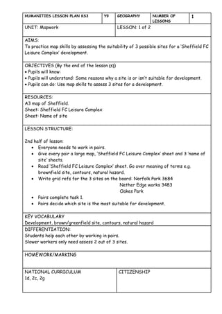
- 1. HUMANITIES LESSON PLAN KS3 Y9 GEOGRAPHY NUMBER OF 1 LESSONS UNIT: Mapwork LESSON: 1 of 2 AIMS: To practice map skills by assessing the suitability of 3 possible sites for a ‘Sheffield FC Leisure Complex’ development. OBJECTIVES (By the end of the lesson (s)) • Pupils will know: • Pupils will understand: Some reasons why a site is or isn’t suitable for development. • Pupils can do: Use map skills to assess 3 sites for a development. RESOURCES: A3 map of Sheffield. Sheet: Sheffield FC Leisure Complex Sheet: Name of site LESSON STRUCTURE: 2nd half of lesson: • Everyone needs to work in pairs. • Give every pair a large map, ‘Sheffield FC Leisure Complex’ sheet and 3 ‘name of site’ sheets. • Read ‘Sheffield FC Leisure Complex’ sheet. Go over meaning of terms e.g. brownfield site, contours, natural hazard. • Write grid refs for the 3 sites on the board: Norfolk Park 3684 Nether Edge works 3483 Oakes Park • Pairs complete task 1. • Pairs decide which site is the most suitable for development. KEY VOCABULARY Development, brown/greenfield site, contours, natural hazard DIFFERENTIATION: Students help each other by working in pairs. Slower workers only need assess 2 out of 3 sites. HOMEWORK/MARKING NATIONAL CURRICULUM CITIZENSHIP 1d, 2c, 2g
- 2. HUMANITIES LESSON PLAN KS3 Y9 GEOGRAPHY NUMBER OF 1 LESSONS UNIT: Mapwork LESSON: 2 of 2 AIMS: To plan a ‘Sheffield FC Leisure Complex’ development with relevant information gathered by using map skills. OBJECTIVES (By the end of the lesson (s)) • Pupils will know: • Pupils will understand: That map skills provides the range of information needed to make a decision on the suitability of a site. • Pupils can do: Plan a development which overcomes local problems evident on a map of the area. RESOURCES: A3 maps of Sheffield A3 sheet A5 large-scale maps of each development site Sheet: Sheffield FC Leisure Complex LESSON STRUCTURE: • Students work in same pairs as last week. • Give every pair a large map, a plain A3 sheet, an A5 map of their chosen site. • Pairs complete task 2. • At the end of the lesson give 2 or 3 pairs a few minutes to present their plan to the class. Discuss pros and cons as a class. KEY VOCABULARY Development, brown/greenfield site, contours, natural hazard DIFFERENTIATION: By outcome. HOMEWORK/MARKING /10 for skills and understanding NATIONAL CURRICULUM CITIZENSHIP 1f, 2g,