SlideShare une entreprise Scribd logo
1  sur  13
Télécharger pour lire hors ligne
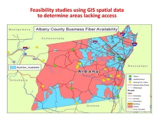
Feasibility studies using GIS spatial data
to determine areas lacking access
Fiber Design Efficiencies cost savings
1. Drive teams dispatched to drive up
and down streets in a target area to
determine Aerial vs. Underground
construction
2. Drive teams sketch proposed routes
and send to CAD to create prelim
field drawings, usually takes weeks to
convert field notes to actual drawings
for the field
3. After prelim route drawings created
in CAD drive teams re dispatched to
collect pole data & construction
details for CDs
4. Field data collected sent in to
complete pole applications, ROW
permits and to the CAD Dept. to
create a set of actual Construction
Drawings
1. Aerial vs. Underground assessment
completed via raster images
embedded in GIS mapping takes days
vs. weeks or months
2. Route drawings are created in
mapping as part of the assessment
process. A few clicks and you print
scaled field drawings for survey
teams.
3. The scaled GIS drawings go to the
field so teams can collect pole data &
verify underground constructability.
4. Field data can be collected and input
electronically to create CDs. Mapping
utilities can auto complete pole
applications, determine
municipalities to contacted for
permits.
Traditional Method Our Approach
Aerial & Underground Fiber Build Cost Synopsis
Some communications providers have excess fiber strands. Fiber count in cables ranges from 6 to
24 near residences and individual businesses to more than 1,000 on backbone routes. The cost of
a 6-count fiber cable is $2,000 per mile, while an 864-count cable is $50,000 per mile, implying a
marginal cost of approximately $50 per fiber per mile. Actual costs for fiber purchase or lease, of
course, reflect market costs and depend on the total availability of fiber over the route–and are
thus, typically, considerably higher; however, fiber lease or purchase may be a serious
consideration over routes where construction is difficult or costly and considerable fiber has
already been installed (e.g., river crossings, tunnels).
Aerial Versus Underground Typical construction is a mixture of aerial and underground
techniques. Aerial construction can be completed for $20,000 per mile. Aerial construction may
be more expensive when poles are crowded or when the utility pole owner charges high rates for
access. Worst-case costs can be $100,000 per mile (which usually would lead a network owner to
build underground or over another route). Underground construction also has a wide cost range.
In areas where restoration is not important and long continuous runs are possible (e.g., rural
areas, in dirt, on the side of interstate roads), “plowing” the fiber into the ground is an
inexpensive option— approximately $40,000 per mile. In more built-up areas, directional boring
is necessary, because it is less destructive to the right-of-way and requires less restoration. Boring
is more expensive, approximately $60,000 to $100,000 per mile. Boring also limits the amount of
cable and conduit that can be built. (Two 2-inch conduit is a typical limit, corresponding to four
medium-sized fiber optic cables.)
Drawings created in GIS mapping software. Right of Way, Geography and Demographic
Spatial data is imported and analyzed to make the business case. Please note the
elaborate geocompression analytical tools in the drop down window
A few clicks and we print scaled field drawings for teams to drive.
Aerial vs. Underground route assessments are completed using embedding
Raster images translucently in the background of our GIS mapping software.
Screen shot below shows a mile high view of a given target area. GIS designs eliminates the need for field teams driving every
road in the area to see if poles exist on streets for aerial route planning. Red dots are poles for aerial placement, blue dots are
vault placements for underground routes (purple lines).
Screenshot below is zoomed into the center of previous mile high Raster imagery view. Designing
in a virtual world significantly reduces overall engineering time and cost.
How we use imagery to find existing poles for aerial cable routing.
Screenshot below is zoomed into an underground portion to show level of detail
available to accurately design UG paths and structure placement.
Using Raster images embedded translucently in ESRI GIS allows the drafter is able to see actual field conditions as they plan routes and
placement of PON cabinets and underground structures. Traditionally this was done in CAD. All the drafter saw was black and white ROW &
pavement lines. All too often these structures were drawn in middle of sidewalks or other places they couldn’t be installed. The ole “looks
good on paper” was not an efficient method of network drawing creation .
Below depicts how we use Google Earth or Bing street view feature to conduct a
virtual survey of planned routes. In doing so we assess the extent of aerial make ready
and identify UG constructability issues.
Note this street is very light make ready (only one cable attached) and has existing UG fiber. You can see the fiber optic
cable marker post.
Electronic pole data collection for aerial attachments.
The attachments can be captured via (DMT) Digital Measuring Technology. We can import
electronic pole data to GIS using ESRI conversion tools.
Below is example of the Ocalc system
Osmose developed for the RBOC ‘s.
Below is GE’s answer to the
Osmose product offering
GIS data exported to auto populate pole sheets and attachment applications reducing
field survey costs.
The data can be collected manually (shown below) or electronically . If collected manually we
insert spreadsheet data to mapping via layer attributes.
GIS mapping utilities also determine municipalities, agencies and pole owners to be
contacted for cable attachments, ROW, zoning and permitting.
Below is a sample Verizon Pole Application
Below is a typical neighborhood
demographic shown in spatial data
OSP Fiber Installation Tracking and Splicing Quality Control
Fiber design efficiencies cost savings

Contenu connexe

Tendances

Ilmastotalkoot: Robbert Lohmann
Ilmastotalkoot: Robbert LohmannIlmastotalkoot: Robbert Lohmann
Ilmastotalkoot: Robbert LohmannDemos Helsinki
 
Real time path planning based on hybrid-vanet-enhanced transportation system
Real time path planning based on hybrid-vanet-enhanced transportation systemReal time path planning based on hybrid-vanet-enhanced transportation system
Real time path planning based on hybrid-vanet-enhanced transportation systemShakas Technologies
 
Workshop: Access to Public Data for Digital Road Maps
Workshop: Access to Public Data for Digital Road MapsWorkshop: Access to Public Data for Digital Road Maps
Workshop: Access to Public Data for Digital Road MapsGeoCommunity
 
2010 Gist
2010 Gist2010 Gist
2010 Gistfjudson
 
Advanced KML with GRASS GIS
Advanced KML with GRASS GIS Advanced KML with GRASS GIS
Advanced KML with GRASS GIS Peter Löwe
 
GISImplementationInDesignWorkflows
GISImplementationInDesignWorkflowsGISImplementationInDesignWorkflows
GISImplementationInDesignWorkflowsZeev Somer
 
18th Annual Congress of the New Urbanism "Building Safer Streets for Healthie...
18th Annual Congress of the New Urbanism "Building Safer Streets for Healthie...18th Annual Congress of the New Urbanism "Building Safer Streets for Healthie...
18th Annual Congress of the New Urbanism "Building Safer Streets for Healthie...Transpo Group
 
ArcGIS Schematics: Dealing with Connectivity
ArcGIS Schematics: Dealing with ConnectivityArcGIS Schematics: Dealing with Connectivity
ArcGIS Schematics: Dealing with ConnectivityEsri
 
EVALUATION OF (GPS/GLONASS) PATCH VERSUS RF GPS (L1) PATCHANTENNA PERFORMANCE...
EVALUATION OF (GPS/GLONASS) PATCH VERSUS RF GPS (L1) PATCHANTENNA PERFORMANCE...EVALUATION OF (GPS/GLONASS) PATCH VERSUS RF GPS (L1) PATCHANTENNA PERFORMANCE...
EVALUATION OF (GPS/GLONASS) PATCH VERSUS RF GPS (L1) PATCHANTENNA PERFORMANCE...IJCSEA Journal
 

Tendances (10)

Ilmastotalkoot: Robbert Lohmann
Ilmastotalkoot: Robbert LohmannIlmastotalkoot: Robbert Lohmann
Ilmastotalkoot: Robbert Lohmann
 
Real time path planning based on hybrid-vanet-enhanced transportation system
Real time path planning based on hybrid-vanet-enhanced transportation systemReal time path planning based on hybrid-vanet-enhanced transportation system
Real time path planning based on hybrid-vanet-enhanced transportation system
 
Workshop: Access to Public Data for Digital Road Maps
Workshop: Access to Public Data for Digital Road MapsWorkshop: Access to Public Data for Digital Road Maps
Workshop: Access to Public Data for Digital Road Maps
 
BREEZE ROADS Overview
BREEZE ROADS OverviewBREEZE ROADS Overview
BREEZE ROADS Overview
 
2010 Gist
2010 Gist2010 Gist
2010 Gist
 
Advanced KML with GRASS GIS
Advanced KML with GRASS GIS Advanced KML with GRASS GIS
Advanced KML with GRASS GIS
 
GISImplementationInDesignWorkflows
GISImplementationInDesignWorkflowsGISImplementationInDesignWorkflows
GISImplementationInDesignWorkflows
 
18th Annual Congress of the New Urbanism "Building Safer Streets for Healthie...
18th Annual Congress of the New Urbanism "Building Safer Streets for Healthie...18th Annual Congress of the New Urbanism "Building Safer Streets for Healthie...
18th Annual Congress of the New Urbanism "Building Safer Streets for Healthie...
 
ArcGIS Schematics: Dealing with Connectivity
ArcGIS Schematics: Dealing with ConnectivityArcGIS Schematics: Dealing with Connectivity
ArcGIS Schematics: Dealing with Connectivity
 
EVALUATION OF (GPS/GLONASS) PATCH VERSUS RF GPS (L1) PATCHANTENNA PERFORMANCE...
EVALUATION OF (GPS/GLONASS) PATCH VERSUS RF GPS (L1) PATCHANTENNA PERFORMANCE...EVALUATION OF (GPS/GLONASS) PATCH VERSUS RF GPS (L1) PATCHANTENNA PERFORMANCE...
EVALUATION OF (GPS/GLONASS) PATCH VERSUS RF GPS (L1) PATCHANTENNA PERFORMANCE...
 

En vedette

Study for FIBRE-BR Backbone Network Architecture
Study for FIBRE-BR Backbone Network ArchitectureStudy for FIBRE-BR Backbone Network Architecture
Study for FIBRE-BR Backbone Network ArchitectureFIBRE Testbed
 
Madcom osp design & engineering capabilities
Madcom osp design  & engineering capabilitiesMadcom osp design  & engineering capabilities
Madcom osp design & engineering capabilitiesRich Frank
 
Fttx planning and design
Fttx planning and designFttx planning and design
Fttx planning and designAhmed Hamdy
 
Project ManagementOf Telecom Project A Case Study
Project ManagementOf Telecom Project A Case StudyProject ManagementOf Telecom Project A Case Study
Project ManagementOf Telecom Project A Case StudyDjadja Sardjana
 
Accounting scandals-Vanya Brown
Accounting scandals-Vanya BrownAccounting scandals-Vanya Brown
Accounting scandals-Vanya BrownVanya Brown
 
PNAS-2016-Gielen-1606927113
PNAS-2016-Gielen-1606927113PNAS-2016-Gielen-1606927113
PNAS-2016-Gielen-1606927113Raphaelle Hours
 
Annual report draft-v2
Annual report draft-v2Annual report draft-v2
Annual report draft-v2Anil Krishna
 
Cheap flower girl dresses nz,latest flower girl gowns online cmdress.co.nz
Cheap flower girl dresses nz,latest flower girl gowns online   cmdress.co.nzCheap flower girl dresses nz,latest flower girl gowns online   cmdress.co.nz
Cheap flower girl dresses nz,latest flower girl gowns online cmdress.co.nzGudeer Kitty
 
Cordial Labelling Of K-Regular Bipartite Graphs for K = 1, 2, N, N-1 Where K ...
Cordial Labelling Of K-Regular Bipartite Graphs for K = 1, 2, N, N-1 Where K ...Cordial Labelling Of K-Regular Bipartite Graphs for K = 1, 2, N, N-1 Where K ...
Cordial Labelling Of K-Regular Bipartite Graphs for K = 1, 2, N, N-1 Where K ...IOSR Journals
 
CERTIFICATE OF ADDRESS REGISTRATION [ SKTTS ]
CERTIFICATE OF ADDRESS REGISTRATION [ SKTTS ]CERTIFICATE OF ADDRESS REGISTRATION [ SKTTS ]
CERTIFICATE OF ADDRESS REGISTRATION [ SKTTS ]legalservice
 
Evaluation of the Biochemical Composition of Four Marine Algae and Its Nutrit...
Evaluation of the Biochemical Composition of Four Marine Algae and Its Nutrit...Evaluation of the Biochemical Composition of Four Marine Algae and Its Nutrit...
Evaluation of the Biochemical Composition of Four Marine Algae and Its Nutrit...IOSR Journals
 
Broadband Access in Albany, Columbia, Greene and Schoharie Counties of NYS
Broadband Access in Albany, Columbia, Greene and Schoharie Counties of NYSBroadband Access in Albany, Columbia, Greene and Schoharie Counties of NYS
Broadband Access in Albany, Columbia, Greene and Schoharie Counties of NYSRich Frank
 

En vedette (14)

Study for FIBRE-BR Backbone Network Architecture
Study for FIBRE-BR Backbone Network ArchitectureStudy for FIBRE-BR Backbone Network Architecture
Study for FIBRE-BR Backbone Network Architecture
 
Madcom osp design & engineering capabilities
Madcom osp design  & engineering capabilitiesMadcom osp design  & engineering capabilities
Madcom osp design & engineering capabilities
 
How fiber works
How fiber worksHow fiber works
How fiber works
 
Fttx planning and design
Fttx planning and designFttx planning and design
Fttx planning and design
 
Project ManagementOf Telecom Project A Case Study
Project ManagementOf Telecom Project A Case StudyProject ManagementOf Telecom Project A Case Study
Project ManagementOf Telecom Project A Case Study
 
Accounting scandals-Vanya Brown
Accounting scandals-Vanya BrownAccounting scandals-Vanya Brown
Accounting scandals-Vanya Brown
 
PNAS-2016-Gielen-1606927113
PNAS-2016-Gielen-1606927113PNAS-2016-Gielen-1606927113
PNAS-2016-Gielen-1606927113
 
Annual report draft-v2
Annual report draft-v2Annual report draft-v2
Annual report draft-v2
 
Cheap flower girl dresses nz,latest flower girl gowns online cmdress.co.nz
Cheap flower girl dresses nz,latest flower girl gowns online   cmdress.co.nzCheap flower girl dresses nz,latest flower girl gowns online   cmdress.co.nz
Cheap flower girl dresses nz,latest flower girl gowns online cmdress.co.nz
 
G017664551
G017664551G017664551
G017664551
 
Cordial Labelling Of K-Regular Bipartite Graphs for K = 1, 2, N, N-1 Where K ...
Cordial Labelling Of K-Regular Bipartite Graphs for K = 1, 2, N, N-1 Where K ...Cordial Labelling Of K-Regular Bipartite Graphs for K = 1, 2, N, N-1 Where K ...
Cordial Labelling Of K-Regular Bipartite Graphs for K = 1, 2, N, N-1 Where K ...
 
CERTIFICATE OF ADDRESS REGISTRATION [ SKTTS ]
CERTIFICATE OF ADDRESS REGISTRATION [ SKTTS ]CERTIFICATE OF ADDRESS REGISTRATION [ SKTTS ]
CERTIFICATE OF ADDRESS REGISTRATION [ SKTTS ]
 
Evaluation of the Biochemical Composition of Four Marine Algae and Its Nutrit...
Evaluation of the Biochemical Composition of Four Marine Algae and Its Nutrit...Evaluation of the Biochemical Composition of Four Marine Algae and Its Nutrit...
Evaluation of the Biochemical Composition of Four Marine Algae and Its Nutrit...
 
Broadband Access in Albany, Columbia, Greene and Schoharie Counties of NYS
Broadband Access in Albany, Columbia, Greene and Schoharie Counties of NYSBroadband Access in Albany, Columbia, Greene and Schoharie Counties of NYS
Broadband Access in Albany, Columbia, Greene and Schoharie Counties of NYS
 

Similaire à Fiber design efficiencies cost savings

Cost Effective Muni Broadband Design
Cost Effective Muni Broadband DesignCost Effective Muni Broadband Design
Cost Effective Muni Broadband DesignRich Frank
 
Madcom osp design, engineering & construction capabilities
Madcom osp design, engineering & construction capabilitiesMadcom osp design, engineering & construction capabilities
Madcom osp design, engineering & construction capabilitiesRich Frank
 
Broadband Fiber for a Tiny Town in the mountains of WV
Broadband Fiber for a Tiny Town in the mountains of WVBroadband Fiber for a Tiny Town in the mountains of WV
Broadband Fiber for a Tiny Town in the mountains of WVRich Frank
 
IRJET- Bus Route Optimization in Jyothi Engineering College using ARC- GIS
IRJET- Bus Route Optimization in Jyothi Engineering College using ARC- GISIRJET- Bus Route Optimization in Jyothi Engineering College using ARC- GIS
IRJET- Bus Route Optimization in Jyothi Engineering College using ARC- GISIRJET Journal
 
Unique methods of GIS in Transportation
Unique methods of GIS in TransportationUnique methods of GIS in Transportation
Unique methods of GIS in TransportationAndrew Harrison
 
Intro GIS.pptx
Intro GIS.pptxIntro GIS.pptx
Intro GIS.pptxSamiDan2
 
2017 PLSC Track: Using a Standard Version of ArcMap with External VRS Recieve...
2017 PLSC Track: Using a Standard Version of ArcMap with External VRS Recieve...2017 PLSC Track: Using a Standard Version of ArcMap with External VRS Recieve...
2017 PLSC Track: Using a Standard Version of ArcMap with External VRS Recieve...GIS in the Rockies
 
Visicom 3d models usage
Visicom 3d models usageVisicom 3d models usage
Visicom 3d models usageSaboor Marwat
 
The use of GIS for the development of the A9 dual-carriageway
The use of GIS for the development of the A9 dual-carriagewayThe use of GIS for the development of the A9 dual-carriageway
The use of GIS for the development of the A9 dual-carriagewayPeter McCready
 
Network analysis and Geocoding.
Network analysis and Geocoding.Network analysis and Geocoding.
Network analysis and Geocoding.Habiba28
 
Use of AI in commuting
Use of AI in commutingUse of AI in commuting
Use of AI in commutingBansi Mehta
 
Handheld augmented reality_for_underground_infrast
Handheld augmented reality_for_underground_infrastHandheld augmented reality_for_underground_infrast
Handheld augmented reality_for_underground_infrastHelloWorld121381
 
Unique methods of GIS analysis for transportation 2010
Unique methods of GIS analysis for transportation 2010Unique methods of GIS analysis for transportation 2010
Unique methods of GIS analysis for transportation 2010Andrew Harrison
 
A cost-effective GPS-aided autonomous guided vehicle for global path planning
A cost-effective GPS-aided autonomous guided vehicle for global path planningA cost-effective GPS-aided autonomous guided vehicle for global path planning
A cost-effective GPS-aided autonomous guided vehicle for global path planningjournalBEEI
 
PREPARATION OF ROAD NETWORK FROM SATELLITE IMAGERY
PREPARATION OF ROAD NETWORK FROM SATELLITE IMAGERYPREPARATION OF ROAD NETWORK FROM SATELLITE IMAGERY
PREPARATION OF ROAD NETWORK FROM SATELLITE IMAGERYPhilson Philipose
 
Capgemini ses - smart grid operational services - gis pov (gr)
Capgemini   ses - smart grid operational services - gis pov (gr)Capgemini   ses - smart grid operational services - gis pov (gr)
Capgemini ses - smart grid operational services - gis pov (gr)Gord Reynolds
 
11.concept for a web map implementation with faster query response
11.concept for a web map implementation with faster query response11.concept for a web map implementation with faster query response
11.concept for a web map implementation with faster query responseAlexander Decker
 

Similaire à Fiber design efficiencies cost savings (20)

Cost Effective Muni Broadband Design
Cost Effective Muni Broadband DesignCost Effective Muni Broadband Design
Cost Effective Muni Broadband Design
 
Madcom osp design, engineering & construction capabilities
Madcom osp design, engineering & construction capabilitiesMadcom osp design, engineering & construction capabilities
Madcom osp design, engineering & construction capabilities
 
Broadband Fiber for a Tiny Town in the mountains of WV
Broadband Fiber for a Tiny Town in the mountains of WVBroadband Fiber for a Tiny Town in the mountains of WV
Broadband Fiber for a Tiny Town in the mountains of WV
 
IRJET- Bus Route Optimization in Jyothi Engineering College using ARC- GIS
IRJET- Bus Route Optimization in Jyothi Engineering College using ARC- GISIRJET- Bus Route Optimization in Jyothi Engineering College using ARC- GIS
IRJET- Bus Route Optimization in Jyothi Engineering College using ARC- GIS
 
Unique methods of GIS in Transportation
Unique methods of GIS in TransportationUnique methods of GIS in Transportation
Unique methods of GIS in Transportation
 
Intro GIS.pptx
Intro GIS.pptxIntro GIS.pptx
Intro GIS.pptx
 
2017 PLSC Track: Using a Standard Version of ArcMap with External VRS Recieve...
2017 PLSC Track: Using a Standard Version of ArcMap with External VRS Recieve...2017 PLSC Track: Using a Standard Version of ArcMap with External VRS Recieve...
2017 PLSC Track: Using a Standard Version of ArcMap with External VRS Recieve...
 
Visicom 3d models usage
Visicom 3d models usageVisicom 3d models usage
Visicom 3d models usage
 
The use of GIS for the development of the A9 dual-carriageway
The use of GIS for the development of the A9 dual-carriagewayThe use of GIS for the development of the A9 dual-carriageway
The use of GIS for the development of the A9 dual-carriageway
 
Network analysis and Geocoding.
Network analysis and Geocoding.Network analysis and Geocoding.
Network analysis and Geocoding.
 
Mahendran
MahendranMahendran
Mahendran
 
ERROR ESTIMATION IN DEVELOPING GIS MAPS USING DIFFERENT INPUT METHODS OF LAND...
ERROR ESTIMATION IN DEVELOPING GIS MAPS USING DIFFERENT INPUT METHODS OF LAND...ERROR ESTIMATION IN DEVELOPING GIS MAPS USING DIFFERENT INPUT METHODS OF LAND...
ERROR ESTIMATION IN DEVELOPING GIS MAPS USING DIFFERENT INPUT METHODS OF LAND...
 
Use of AI in commuting
Use of AI in commutingUse of AI in commuting
Use of AI in commuting
 
Data sources and input in GIS
Data  sources and input in GISData  sources and input in GIS
Data sources and input in GIS
 
Handheld augmented reality_for_underground_infrast
Handheld augmented reality_for_underground_infrastHandheld augmented reality_for_underground_infrast
Handheld augmented reality_for_underground_infrast
 
Unique methods of GIS analysis for transportation 2010
Unique methods of GIS analysis for transportation 2010Unique methods of GIS analysis for transportation 2010
Unique methods of GIS analysis for transportation 2010
 
A cost-effective GPS-aided autonomous guided vehicle for global path planning
A cost-effective GPS-aided autonomous guided vehicle for global path planningA cost-effective GPS-aided autonomous guided vehicle for global path planning
A cost-effective GPS-aided autonomous guided vehicle for global path planning
 
PREPARATION OF ROAD NETWORK FROM SATELLITE IMAGERY
PREPARATION OF ROAD NETWORK FROM SATELLITE IMAGERYPREPARATION OF ROAD NETWORK FROM SATELLITE IMAGERY
PREPARATION OF ROAD NETWORK FROM SATELLITE IMAGERY
 
Capgemini ses - smart grid operational services - gis pov (gr)
Capgemini   ses - smart grid operational services - gis pov (gr)Capgemini   ses - smart grid operational services - gis pov (gr)
Capgemini ses - smart grid operational services - gis pov (gr)
 
11.concept for a web map implementation with faster query response
11.concept for a web map implementation with faster query response11.concept for a web map implementation with faster query response
11.concept for a web map implementation with faster query response
 

Plus de Rich Frank

Broadband Planning Done Right
Broadband Planning Done RightBroadband Planning Done Right
Broadband Planning Done RightRich Frank
 
Cohoes Broadband Planning
Cohoes Broadband PlanningCohoes Broadband Planning
Cohoes Broadband PlanningRich Frank
 
Snapshot 01-17
Snapshot 01-17Snapshot 01-17
Snapshot 01-17Rich Frank
 
Fiber optic construction planning 101
Fiber optic construction planning 101Fiber optic construction planning 101
Fiber optic construction planning 101Rich Frank
 
Madcom offers a Broadband Feasibility Study Toolkit for Municipalities and Ec...
Madcom offers a Broadband Feasibility Study Toolkit for Municipalities and Ec...Madcom offers a Broadband Feasibility Study Toolkit for Municipalities and Ec...
Madcom offers a Broadband Feasibility Study Toolkit for Municipalities and Ec...Rich Frank
 
Madcom analyzes bermuda ftth design
Madcom analyzes bermuda ftth designMadcom analyzes bermuda ftth design
Madcom analyzes bermuda ftth designRich Frank
 
Kandiyohi county broadband feasibility study proposal 2
Kandiyohi county broadband feasibility study proposal 2Kandiyohi county broadband feasibility study proposal 2
Kandiyohi county broadband feasibility study proposal 2Rich Frank
 
Madcom analyzes the need for broadband in eastern pa
Madcom analyzes the need for broadband in eastern paMadcom analyzes the need for broadband in eastern pa
Madcom analyzes the need for broadband in eastern paRich Frank
 
Are NYS’s privately owned lLEC’s to big to fail
Are NYS’s privately owned lLEC’s to big to failAre NYS’s privately owned lLEC’s to big to fail
Are NYS’s privately owned lLEC’s to big to failRich Frank
 
Weekend Warriors Connecting Buffalo
Weekend Warriors Connecting BuffaloWeekend Warriors Connecting Buffalo
Weekend Warriors Connecting BuffaloRich Frank
 
Broadband Availability Near NYS Capitol (albany, columbia & greene counties)
Broadband Availability Near NYS Capitol (albany, columbia & greene counties)Broadband Availability Near NYS Capitol (albany, columbia & greene counties)
Broadband Availability Near NYS Capitol (albany, columbia & greene counties)Rich Frank
 
Broadband Access in NYS
Broadband Access in NYSBroadband Access in NYS
Broadband Access in NYSRich Frank
 
Business case for rural broadband in NYS (Albany, Columbia & Greene counties)
Business case for rural broadband in NYS (Albany, Columbia & Greene counties)Business case for rural broadband in NYS (Albany, Columbia & Greene counties)
Business case for rural broadband in NYS (Albany, Columbia & Greene counties)Rich Frank
 

Plus de Rich Frank (13)

Broadband Planning Done Right
Broadband Planning Done RightBroadband Planning Done Right
Broadband Planning Done Right
 
Cohoes Broadband Planning
Cohoes Broadband PlanningCohoes Broadband Planning
Cohoes Broadband Planning
 
Snapshot 01-17
Snapshot 01-17Snapshot 01-17
Snapshot 01-17
 
Fiber optic construction planning 101
Fiber optic construction planning 101Fiber optic construction planning 101
Fiber optic construction planning 101
 
Madcom offers a Broadband Feasibility Study Toolkit for Municipalities and Ec...
Madcom offers a Broadband Feasibility Study Toolkit for Municipalities and Ec...Madcom offers a Broadband Feasibility Study Toolkit for Municipalities and Ec...
Madcom offers a Broadband Feasibility Study Toolkit for Municipalities and Ec...
 
Madcom analyzes bermuda ftth design
Madcom analyzes bermuda ftth designMadcom analyzes bermuda ftth design
Madcom analyzes bermuda ftth design
 
Kandiyohi county broadband feasibility study proposal 2
Kandiyohi county broadband feasibility study proposal 2Kandiyohi county broadband feasibility study proposal 2
Kandiyohi county broadband feasibility study proposal 2
 
Madcom analyzes the need for broadband in eastern pa
Madcom analyzes the need for broadband in eastern paMadcom analyzes the need for broadband in eastern pa
Madcom analyzes the need for broadband in eastern pa
 
Are NYS’s privately owned lLEC’s to big to fail
Are NYS’s privately owned lLEC’s to big to failAre NYS’s privately owned lLEC’s to big to fail
Are NYS’s privately owned lLEC’s to big to fail
 
Weekend Warriors Connecting Buffalo
Weekend Warriors Connecting BuffaloWeekend Warriors Connecting Buffalo
Weekend Warriors Connecting Buffalo
 
Broadband Availability Near NYS Capitol (albany, columbia & greene counties)
Broadband Availability Near NYS Capitol (albany, columbia & greene counties)Broadband Availability Near NYS Capitol (albany, columbia & greene counties)
Broadband Availability Near NYS Capitol (albany, columbia & greene counties)
 
Broadband Access in NYS
Broadband Access in NYSBroadband Access in NYS
Broadband Access in NYS
 
Business case for rural broadband in NYS (Albany, Columbia & Greene counties)
Business case for rural broadband in NYS (Albany, Columbia & Greene counties)Business case for rural broadband in NYS (Albany, Columbia & Greene counties)
Business case for rural broadband in NYS (Albany, Columbia & Greene counties)
 

Dernier

Verification of thevenin's theorem for BEEE Lab (1).pptx
Verification of thevenin's theorem for BEEE Lab (1).pptxVerification of thevenin's theorem for BEEE Lab (1).pptx
Verification of thevenin's theorem for BEEE Lab (1).pptxchumtiyababu
 
Navigating Complexity: The Role of Trusted Partners and VIAS3D in Dassault Sy...
Navigating Complexity: The Role of Trusted Partners and VIAS3D in Dassault Sy...Navigating Complexity: The Role of Trusted Partners and VIAS3D in Dassault Sy...
Navigating Complexity: The Role of Trusted Partners and VIAS3D in Dassault Sy...Arindam Chakraborty, Ph.D., P.E. (CA, TX)
 
Double Revolving field theory-how the rotor develops torque
Double Revolving field theory-how the rotor develops torqueDouble Revolving field theory-how the rotor develops torque
Double Revolving field theory-how the rotor develops torqueBhangaleSonal
 
A CASE STUDY ON CERAMIC INDUSTRY OF BANGLADESH.pptx
A CASE STUDY ON CERAMIC INDUSTRY OF BANGLADESH.pptxA CASE STUDY ON CERAMIC INDUSTRY OF BANGLADESH.pptx
A CASE STUDY ON CERAMIC INDUSTRY OF BANGLADESH.pptxmaisarahman1
 
School management system project Report.pdf
School management system project Report.pdfSchool management system project Report.pdf
School management system project Report.pdfKamal Acharya
 
"Lesotho Leaps Forward: A Chronicle of Transformative Developments"
"Lesotho Leaps Forward: A Chronicle of Transformative Developments""Lesotho Leaps Forward: A Chronicle of Transformative Developments"
"Lesotho Leaps Forward: A Chronicle of Transformative Developments"mphochane1998
 
Online food ordering system project report.pdf
Online food ordering system project report.pdfOnline food ordering system project report.pdf
Online food ordering system project report.pdfKamal Acharya
 
A Study of Urban Area Plan for Pabna Municipality
A Study of Urban Area Plan for Pabna MunicipalityA Study of Urban Area Plan for Pabna Municipality
A Study of Urban Area Plan for Pabna MunicipalityMorshed Ahmed Rahath
 
HOA1&2 - Module 3 - PREHISTORCI ARCHITECTURE OF KERALA.pptx
HOA1&2 - Module 3 - PREHISTORCI ARCHITECTURE OF KERALA.pptxHOA1&2 - Module 3 - PREHISTORCI ARCHITECTURE OF KERALA.pptx
HOA1&2 - Module 3 - PREHISTORCI ARCHITECTURE OF KERALA.pptxSCMS School of Architecture
 
Computer Networks Basics of Network Devices
Computer Networks  Basics of Network DevicesComputer Networks  Basics of Network Devices
Computer Networks Basics of Network DevicesChandrakantDivate1
 
Unleashing the Power of the SORA AI lastest leap
Unleashing the Power of the SORA AI lastest leapUnleashing the Power of the SORA AI lastest leap
Unleashing the Power of the SORA AI lastest leapRishantSharmaFr
 
kiln thermal load.pptx kiln tgermal load
kiln thermal load.pptx kiln tgermal loadkiln thermal load.pptx kiln tgermal load
kiln thermal load.pptx kiln tgermal loadhamedmustafa094
 
Standard vs Custom Battery Packs - Decoding the Power Play
Standard vs Custom Battery Packs - Decoding the Power PlayStandard vs Custom Battery Packs - Decoding the Power Play
Standard vs Custom Battery Packs - Decoding the Power PlayEpec Engineered Technologies
 
DC MACHINE-Motoring and generation, Armature circuit equation
DC MACHINE-Motoring and generation, Armature circuit equationDC MACHINE-Motoring and generation, Armature circuit equation
DC MACHINE-Motoring and generation, Armature circuit equationBhangaleSonal
 
Tamil Call Girls Bhayandar WhatsApp +91-9930687706, Best Service
Tamil Call Girls Bhayandar WhatsApp +91-9930687706, Best ServiceTamil Call Girls Bhayandar WhatsApp +91-9930687706, Best Service
Tamil Call Girls Bhayandar WhatsApp +91-9930687706, Best Servicemeghakumariji156
 
Bhubaneswar🌹Call Girls Bhubaneswar ❤Komal 9777949614 💟 Full Trusted CALL GIRL...
Bhubaneswar🌹Call Girls Bhubaneswar ❤Komal 9777949614 💟 Full Trusted CALL GIRL...Bhubaneswar🌹Call Girls Bhubaneswar ❤Komal 9777949614 💟 Full Trusted CALL GIRL...
Bhubaneswar🌹Call Girls Bhubaneswar ❤Komal 9777949614 💟 Full Trusted CALL GIRL...Call Girls Mumbai
 
Hostel management system project report..pdf
Hostel management system project report..pdfHostel management system project report..pdf
Hostel management system project report..pdfKamal Acharya
 
Design For Accessibility: Getting it right from the start
Design For Accessibility: Getting it right from the startDesign For Accessibility: Getting it right from the start
Design For Accessibility: Getting it right from the startQuintin Balsdon
 
Employee leave management system project.
Employee leave management system project.Employee leave management system project.
Employee leave management system project.Kamal Acharya
 

Dernier (20)

Verification of thevenin's theorem for BEEE Lab (1).pptx
Verification of thevenin's theorem for BEEE Lab (1).pptxVerification of thevenin's theorem for BEEE Lab (1).pptx
Verification of thevenin's theorem for BEEE Lab (1).pptx
 
Navigating Complexity: The Role of Trusted Partners and VIAS3D in Dassault Sy...
Navigating Complexity: The Role of Trusted Partners and VIAS3D in Dassault Sy...Navigating Complexity: The Role of Trusted Partners and VIAS3D in Dassault Sy...
Navigating Complexity: The Role of Trusted Partners and VIAS3D in Dassault Sy...
 
Double Revolving field theory-how the rotor develops torque
Double Revolving field theory-how the rotor develops torqueDouble Revolving field theory-how the rotor develops torque
Double Revolving field theory-how the rotor develops torque
 
A CASE STUDY ON CERAMIC INDUSTRY OF BANGLADESH.pptx
A CASE STUDY ON CERAMIC INDUSTRY OF BANGLADESH.pptxA CASE STUDY ON CERAMIC INDUSTRY OF BANGLADESH.pptx
A CASE STUDY ON CERAMIC INDUSTRY OF BANGLADESH.pptx
 
School management system project Report.pdf
School management system project Report.pdfSchool management system project Report.pdf
School management system project Report.pdf
 
"Lesotho Leaps Forward: A Chronicle of Transformative Developments"
"Lesotho Leaps Forward: A Chronicle of Transformative Developments""Lesotho Leaps Forward: A Chronicle of Transformative Developments"
"Lesotho Leaps Forward: A Chronicle of Transformative Developments"
 
Online food ordering system project report.pdf
Online food ordering system project report.pdfOnline food ordering system project report.pdf
Online food ordering system project report.pdf
 
A Study of Urban Area Plan for Pabna Municipality
A Study of Urban Area Plan for Pabna MunicipalityA Study of Urban Area Plan for Pabna Municipality
A Study of Urban Area Plan for Pabna Municipality
 
HOA1&2 - Module 3 - PREHISTORCI ARCHITECTURE OF KERALA.pptx
HOA1&2 - Module 3 - PREHISTORCI ARCHITECTURE OF KERALA.pptxHOA1&2 - Module 3 - PREHISTORCI ARCHITECTURE OF KERALA.pptx
HOA1&2 - Module 3 - PREHISTORCI ARCHITECTURE OF KERALA.pptx
 
Computer Networks Basics of Network Devices
Computer Networks  Basics of Network DevicesComputer Networks  Basics of Network Devices
Computer Networks Basics of Network Devices
 
Unleashing the Power of the SORA AI lastest leap
Unleashing the Power of the SORA AI lastest leapUnleashing the Power of the SORA AI lastest leap
Unleashing the Power of the SORA AI lastest leap
 
Integrated Test Rig For HTFE-25 - Neometrix
Integrated Test Rig For HTFE-25 - NeometrixIntegrated Test Rig For HTFE-25 - Neometrix
Integrated Test Rig For HTFE-25 - Neometrix
 
kiln thermal load.pptx kiln tgermal load
kiln thermal load.pptx kiln tgermal loadkiln thermal load.pptx kiln tgermal load
kiln thermal load.pptx kiln tgermal load
 
Standard vs Custom Battery Packs - Decoding the Power Play
Standard vs Custom Battery Packs - Decoding the Power PlayStandard vs Custom Battery Packs - Decoding the Power Play
Standard vs Custom Battery Packs - Decoding the Power Play
 
DC MACHINE-Motoring and generation, Armature circuit equation
DC MACHINE-Motoring and generation, Armature circuit equationDC MACHINE-Motoring and generation, Armature circuit equation
DC MACHINE-Motoring and generation, Armature circuit equation
 
Tamil Call Girls Bhayandar WhatsApp +91-9930687706, Best Service
Tamil Call Girls Bhayandar WhatsApp +91-9930687706, Best ServiceTamil Call Girls Bhayandar WhatsApp +91-9930687706, Best Service
Tamil Call Girls Bhayandar WhatsApp +91-9930687706, Best Service
 
Bhubaneswar🌹Call Girls Bhubaneswar ❤Komal 9777949614 💟 Full Trusted CALL GIRL...
Bhubaneswar🌹Call Girls Bhubaneswar ❤Komal 9777949614 💟 Full Trusted CALL GIRL...Bhubaneswar🌹Call Girls Bhubaneswar ❤Komal 9777949614 💟 Full Trusted CALL GIRL...
Bhubaneswar🌹Call Girls Bhubaneswar ❤Komal 9777949614 💟 Full Trusted CALL GIRL...
 
Hostel management system project report..pdf
Hostel management system project report..pdfHostel management system project report..pdf
Hostel management system project report..pdf
 
Design For Accessibility: Getting it right from the start
Design For Accessibility: Getting it right from the startDesign For Accessibility: Getting it right from the start
Design For Accessibility: Getting it right from the start
 
Employee leave management system project.
Employee leave management system project.Employee leave management system project.
Employee leave management system project.
 

Fiber design efficiencies cost savings

  • 1. Feasibility studies using GIS spatial data to determine areas lacking access
  • 2. Fiber Design Efficiencies cost savings 1. Drive teams dispatched to drive up and down streets in a target area to determine Aerial vs. Underground construction 2. Drive teams sketch proposed routes and send to CAD to create prelim field drawings, usually takes weeks to convert field notes to actual drawings for the field 3. After prelim route drawings created in CAD drive teams re dispatched to collect pole data & construction details for CDs 4. Field data collected sent in to complete pole applications, ROW permits and to the CAD Dept. to create a set of actual Construction Drawings 1. Aerial vs. Underground assessment completed via raster images embedded in GIS mapping takes days vs. weeks or months 2. Route drawings are created in mapping as part of the assessment process. A few clicks and you print scaled field drawings for survey teams. 3. The scaled GIS drawings go to the field so teams can collect pole data & verify underground constructability. 4. Field data can be collected and input electronically to create CDs. Mapping utilities can auto complete pole applications, determine municipalities to contacted for permits. Traditional Method Our Approach
  • 3. Aerial & Underground Fiber Build Cost Synopsis Some communications providers have excess fiber strands. Fiber count in cables ranges from 6 to 24 near residences and individual businesses to more than 1,000 on backbone routes. The cost of a 6-count fiber cable is $2,000 per mile, while an 864-count cable is $50,000 per mile, implying a marginal cost of approximately $50 per fiber per mile. Actual costs for fiber purchase or lease, of course, reflect market costs and depend on the total availability of fiber over the route–and are thus, typically, considerably higher; however, fiber lease or purchase may be a serious consideration over routes where construction is difficult or costly and considerable fiber has already been installed (e.g., river crossings, tunnels). Aerial Versus Underground Typical construction is a mixture of aerial and underground techniques. Aerial construction can be completed for $20,000 per mile. Aerial construction may be more expensive when poles are crowded or when the utility pole owner charges high rates for access. Worst-case costs can be $100,000 per mile (which usually would lead a network owner to build underground or over another route). Underground construction also has a wide cost range. In areas where restoration is not important and long continuous runs are possible (e.g., rural areas, in dirt, on the side of interstate roads), “plowing” the fiber into the ground is an inexpensive option— approximately $40,000 per mile. In more built-up areas, directional boring is necessary, because it is less destructive to the right-of-way and requires less restoration. Boring is more expensive, approximately $60,000 to $100,000 per mile. Boring also limits the amount of cable and conduit that can be built. (Two 2-inch conduit is a typical limit, corresponding to four medium-sized fiber optic cables.)
  • 4. Drawings created in GIS mapping software. Right of Way, Geography and Demographic Spatial data is imported and analyzed to make the business case. Please note the elaborate geocompression analytical tools in the drop down window A few clicks and we print scaled field drawings for teams to drive.
  • 5. Aerial vs. Underground route assessments are completed using embedding Raster images translucently in the background of our GIS mapping software. Screen shot below shows a mile high view of a given target area. GIS designs eliminates the need for field teams driving every road in the area to see if poles exist on streets for aerial route planning. Red dots are poles for aerial placement, blue dots are vault placements for underground routes (purple lines).
  • 6. Screenshot below is zoomed into the center of previous mile high Raster imagery view. Designing in a virtual world significantly reduces overall engineering time and cost. How we use imagery to find existing poles for aerial cable routing.
  • 7. Screenshot below is zoomed into an underground portion to show level of detail available to accurately design UG paths and structure placement. Using Raster images embedded translucently in ESRI GIS allows the drafter is able to see actual field conditions as they plan routes and placement of PON cabinets and underground structures. Traditionally this was done in CAD. All the drafter saw was black and white ROW & pavement lines. All too often these structures were drawn in middle of sidewalks or other places they couldn’t be installed. The ole “looks good on paper” was not an efficient method of network drawing creation .
  • 8. Below depicts how we use Google Earth or Bing street view feature to conduct a virtual survey of planned routes. In doing so we assess the extent of aerial make ready and identify UG constructability issues. Note this street is very light make ready (only one cable attached) and has existing UG fiber. You can see the fiber optic cable marker post.
  • 9. Electronic pole data collection for aerial attachments. The attachments can be captured via (DMT) Digital Measuring Technology. We can import electronic pole data to GIS using ESRI conversion tools. Below is example of the Ocalc system Osmose developed for the RBOC ‘s. Below is GE’s answer to the Osmose product offering
  • 10. GIS data exported to auto populate pole sheets and attachment applications reducing field survey costs. The data can be collected manually (shown below) or electronically . If collected manually we insert spreadsheet data to mapping via layer attributes.
  • 11. GIS mapping utilities also determine municipalities, agencies and pole owners to be contacted for cable attachments, ROW, zoning and permitting. Below is a sample Verizon Pole Application Below is a typical neighborhood demographic shown in spatial data
  • 12. OSP Fiber Installation Tracking and Splicing Quality Control