SlideShare une entreprise Scribd logo
1  sur  15
© 2 0 1 5 A p p l i e d G e o g r a p h i c s , I n c . S l i d e 1
FME World Tour 2015
GIS/Non-GIS data Interoperability
Business
Data
Other
Spatial
Data
GIS Data
© 2 0 1 5 A p p l i e d G e o g r a p h i c s , I n c . S l i d e 2
Data Overwhelms
© 2 0 1 5 A p p l i e d G e o g r a p h i c s , I n c . S l i d e 3
CADD Data Requires Processing
© 2 0 1 5 A p p l i e d G e o g r a p h i c s , I n c . S l i d e 4
Conceptualize Process
FME
ROW
Geospatial
Data
Process
Geometry
Georeference
Images
Convert
Objects to
Features
Create
Features from
Image
MicroStation
DGN file
Scan
Features
Georef.
Scan
Archive JP2
Georeferenced
© 2 0 1 5 A p p l i e d G e o g r a p h i c s , I n c . S l i d e 5
Define Business Objective
Project Areas
Plats
VTrans ROW Map Viewer
ROW
Geospatial
Data
VTrans
DGN
DGN
DGN
DGN
DGN DGN
CADD to
GIS
Conversion
Vermont
Base Map
Data
PPMS
For Selected
Project:
PPMS &
Artemis Attributes
Project #,
Project Description,
Project History,
CADD DGN filename
& location,
Etc.
Scan
Scan
Artemis
Artemis
Project View
Artemis
Project View
PPMS UIPPMS UI
OnBase
Muni Parcel Data
Linear Referencing
Road Centerlines
Town Boundaries
Ortho Imagery
Utility
ACQ.
OnBase
Doc Mgmt
OnBase
Doc Mgmt
Sell-off
© 2 0 1 5 A p p l i e d G e o g r a p h i c s , I n c . S l i d e 6
Integrated Data Viewers
© 2 0 1 5 A p p l i e d G e o g r a p h i c s , I n c . S l i d e 7
Establish Business Workflow
© 2 0 1 5 A p p l i e d G e o g r a p h i c s , I n c . S l i d e 8
Develop Repeatable Models
• Interop Extension
• FME models
• Python scripts
• Bentley Map
© 2 0 1 5 A p p l i e d G e o g r a p h i c s , I n c . S l i d e 9
Enable End User Action
© 2 0 1 5 A p p l i e d G e o g r a p h i c s , I n c . S l i d e 1 0
Hide Tool Complexities
© 2 0 1 5 A p p l i e d G e o g r a p h i c s , I n c . S l i d e 1 1
Invoke FME Workbench From OS
Private Sub RunSelectedToolButton_Click()
Dim ShellCommand As String
Dim SubFormRecordSet As Recordset
ShellCommand = "C:program filesFMEfme.exe " & Chr(34) & "C:gitcdot_2012-
0228.interoperabilityfmw" & Me.ToolNameCombo.Column(2) & Chr(34)
Set SubFormRecordSet = Me.ToolParameter_subform.Form.Recordset
If Me.ToolParameter_subform.Form.Recordset.RecordCount > 0 Then
SubFormRecordSet.MoveFirst
Do While Not SubFormRecordSet.EOF
ShellCommand = ShellCommand & " --" & SubFormRecordSet!ParameterName & " " & Chr(34)
& SubFormRecordSet!Value & Chr(34)
SubFormRecordSet.MoveNext
Loop
End If
Call Shell(ShellCommand, vbMaximizedFocus)
End Sub
© 2 0 1 5 A p p l i e d G e o g r a p h i c s , I n c . S l i d e 1 2
Retain Source Info
Drawing Area Attributes
PK OBJECTID
pin
source_file
source_path
source_type
source_date
method
quality
projection
offset
unit_of_resolution
units_master
units_sub
accuracy
resolution
plan_scale
SHAPE
SHAPE_LENGTH
SHAPE_AREA
vtrans_row.gdb
features
areas
project
drawing
bridge_point
bridge_line
control_point
control_line
drainage_point
drainage_line
landscape_point
landscape_line
mapping_point
mapping_line
other_point
other_line
pavement_point
pavement_line
roadway_point
roadway_line
Feature Attributes
PK OBJECTID
SHAPE
pin
object_modified_date
source_file
source_path
source_level_number
source_level_description
source_level_name
level_number
level_name
level_description
annotation_label
cell_name
tag_name
tag_description
tag_x
style
color
weight
SHAPE_LENGTH (lines only)
Drawing Areas
Feature Class
Attributes
Common Features
Feature Class
Attributes
Project Area Attributes
PK OBJECTID
pin
project_completion_date
Project Areas
Feature Class
Attributes
Feature Level Metadata
Create Backdrop Features
Level to Feature Mapping & Filtering
© 2 0 1 5 A p p l i e d G e o g r a p h i c s , I n c . S l i d e 1 3
• You have to understand the data
– English, Metric
– Scans, tiffs
– Survey points or ROW lines
– Quality & accuracy
– Vintages/standards
• Data mgmt. best practices provide structure
– On-going, scalable, repeatable, documented
• Workflows
– The operations and methods performed on data
• Lifecycle
– The stages of the data as it flows
Interoperability is not a one time thing
It’s really about the Process
© 2 0 1 5 A p p l i e d G e o g r a p h i c s , I n c . S l i d e 1 4
Understand Lifecycle
Collect
Maintain
Publish
ValidateTransform
Catalog
Archive
Retire
Analyze
Analyze
Integrate
Refresh
Produce
Consume
© 2 0 1 5 A p p l i e d G e o g r a p h i c s , I n c . S l i d e 1 5
Accomplish the Goal

Contenu connexe

Similaire à Using FME for Interoperability between GIS and non-GIS Systems

Pivotal Greenplum 次世代マルチクラウド・データ分析プラットフォーム
Pivotal Greenplum 次世代マルチクラウド・データ分析プラットフォームPivotal Greenplum 次世代マルチクラウド・データ分析プラットフォーム
Pivotal Greenplum 次世代マルチクラウド・データ分析プラットフォーム
Masayuki Matsushita
 

Similaire à Using FME for Interoperability between GIS and non-GIS Systems (20)

Pivotal Greenplum 次世代マルチクラウド・データ分析プラットフォーム
Pivotal Greenplum 次世代マルチクラウド・データ分析プラットフォームPivotal Greenplum 次世代マルチクラウド・データ分析プラットフォーム
Pivotal Greenplum 次世代マルチクラウド・データ分析プラットフォーム
 
JAWS DAYS 2018
JAWS DAYS 2018JAWS DAYS 2018
JAWS DAYS 2018
 
Code Difference Visualization by a Call Tree
Code Difference Visualization by a Call TreeCode Difference Visualization by a Call Tree
Code Difference Visualization by a Call Tree
 
Sprint 131
Sprint 131Sprint 131
Sprint 131
 
mago3D FOSS4G NA 2018
mago3D FOSS4G NA 2018mago3D FOSS4G NA 2018
mago3D FOSS4G NA 2018
 
Introduction to OpenGL.ppt
Introduction to OpenGL.pptIntroduction to OpenGL.ppt
Introduction to OpenGL.ppt
 
5 Ways to Improve Your LiDAR Workflows
5 Ways to Improve Your LiDAR Workflows5 Ways to Improve Your LiDAR Workflows
5 Ways to Improve Your LiDAR Workflows
 
How to Use OpenGL/ES on Native Activity
How to Use OpenGL/ES on Native ActivityHow to Use OpenGL/ES on Native Activity
How to Use OpenGL/ES on Native Activity
 
3D Programming Basics: WebGL
3D Programming Basics: WebGL3D Programming Basics: WebGL
3D Programming Basics: WebGL
 
MapReduce Algorithm Design
MapReduce Algorithm DesignMapReduce Algorithm Design
MapReduce Algorithm Design
 
[Unite Seoul 2019] Mali GPU Architecture and Mobile Studio
[Unite Seoul 2019] Mali GPU Architecture and Mobile Studio [Unite Seoul 2019] Mali GPU Architecture and Mobile Studio
[Unite Seoul 2019] Mali GPU Architecture and Mobile Studio
 
Hadoop 2.0 - Solving the Data Quality Challenge
Hadoop 2.0 - Solving the Data Quality ChallengeHadoop 2.0 - Solving the Data Quality Challenge
Hadoop 2.0 - Solving the Data Quality Challenge
 
Data Quality in the Data Hub with RedPointGlobal
Data Quality in the Data Hub with RedPointGlobalData Quality in the Data Hub with RedPointGlobal
Data Quality in the Data Hub with RedPointGlobal
 
Scaling AI in production using PyTorch
Scaling AI in production using PyTorchScaling AI in production using PyTorch
Scaling AI in production using PyTorch
 
Rpg Pointers And User Space
Rpg Pointers And User SpaceRpg Pointers And User Space
Rpg Pointers And User Space
 
Android 5.0 Lollipop platform change investigation report
Android 5.0 Lollipop platform change investigation reportAndroid 5.0 Lollipop platform change investigation report
Android 5.0 Lollipop platform change investigation report
 
openGL basics for sample program (1).ppt
openGL basics for sample program (1).pptopenGL basics for sample program (1).ppt
openGL basics for sample program (1).ppt
 
openGL basics for sample program.ppt
openGL basics for sample program.pptopenGL basics for sample program.ppt
openGL basics for sample program.ppt
 
5 Ways to Optimize Your LiDAR Data
5 Ways to Optimize Your LiDAR Data5 Ways to Optimize Your LiDAR Data
5 Ways to Optimize Your LiDAR Data
 
Ab initio training Ab-initio Architecture
Ab initio training Ab-initio ArchitectureAb initio training Ab-initio Architecture
Ab initio training Ab-initio Architecture
 

Plus de Safe Software

Cloud Frontiers: A Deep Dive into Serverless Spatial Data and FME
Cloud Frontiers:  A Deep Dive into Serverless Spatial Data and FMECloud Frontiers:  A Deep Dive into Serverless Spatial Data and FME
Cloud Frontiers: A Deep Dive into Serverless Spatial Data and FME
Safe Software
 
Cloud Frontiers: A Deep Dive into Serverless Spatial Data and FME
Cloud Frontiers:  A Deep Dive into Serverless Spatial Data and FMECloud Frontiers:  A Deep Dive into Serverless Spatial Data and FME
Cloud Frontiers: A Deep Dive into Serverless Spatial Data and FME
Safe Software
 
Cloud Revolution: Exploring the New Wave of Serverless Spatial Data
Cloud Revolution: Exploring the New Wave of Serverless Spatial DataCloud Revolution: Exploring the New Wave of Serverless Spatial Data
Cloud Revolution: Exploring the New Wave of Serverless Spatial Data
Safe Software
 
Igniting Next Level Productivity with AI-Infused Data Integration Workflows
Igniting Next Level Productivity with AI-Infused Data Integration WorkflowsIgniting Next Level Productivity with AI-Infused Data Integration Workflows
Igniting Next Level Productivity with AI-Infused Data Integration Workflows
Safe Software
 
Introducing the New FME Community Webinar - Feb 21, 2024 (2).pdf
Introducing the New FME Community Webinar - Feb 21, 2024 (2).pdfIntroducing the New FME Community Webinar - Feb 21, 2024 (2).pdf
Introducing the New FME Community Webinar - Feb 21, 2024 (2).pdf
Safe Software
 
Cloud Revolution: Exploring the New Wave of Serverless Spatial Data
Cloud Revolution: Exploring the New Wave of Serverless Spatial DataCloud Revolution: Exploring the New Wave of Serverless Spatial Data
Cloud Revolution: Exploring the New Wave of Serverless Spatial Data
Safe Software
 
Taking Off with FME: Elevating Airport Operations to New Heights
Taking Off with FME: Elevating Airport Operations to New HeightsTaking Off with FME: Elevating Airport Operations to New Heights
Taking Off with FME: Elevating Airport Operations to New Heights
Safe Software
 
Initiating and Advancing Your Strategic GIS Governance Strategy
Initiating and Advancing Your Strategic GIS Governance StrategyInitiating and Advancing Your Strategic GIS Governance Strategy
Initiating and Advancing Your Strategic GIS Governance Strategy
Safe Software
 
Igniting Next Level Productivity with AI-Infused Data Integration Workflows
Igniting Next Level Productivity with AI-Infused Data Integration Workflows Igniting Next Level Productivity with AI-Infused Data Integration Workflows
Igniting Next Level Productivity with AI-Infused Data Integration Workflows
Safe Software
 

Plus de Safe Software (20)

Cloud Frontiers: A Deep Dive into Serverless Spatial Data and FME
Cloud Frontiers:  A Deep Dive into Serverless Spatial Data and FMECloud Frontiers:  A Deep Dive into Serverless Spatial Data and FME
Cloud Frontiers: A Deep Dive into Serverless Spatial Data and FME
 
Cloud Frontiers: A Deep Dive into Serverless Spatial Data and FME
Cloud Frontiers:  A Deep Dive into Serverless Spatial Data and FMECloud Frontiers:  A Deep Dive into Serverless Spatial Data and FME
Cloud Frontiers: A Deep Dive into Serverless Spatial Data and FME
 
From Event to Action: Accelerate Your Decision Making with Real-Time Automation
From Event to Action: Accelerate Your Decision Making with Real-Time AutomationFrom Event to Action: Accelerate Your Decision Making with Real-Time Automation
From Event to Action: Accelerate Your Decision Making with Real-Time Automation
 
From Event to Action: Accelerate Your Decision Making with Real-Time Automation
From Event to Action:  Accelerate Your Decision Making with Real-Time AutomationFrom Event to Action:  Accelerate Your Decision Making with Real-Time Automation
From Event to Action: Accelerate Your Decision Making with Real-Time Automation
 
Beyond Boundaries: Leveraging No-Code Solutions for Industry Innovation
Beyond Boundaries: Leveraging No-Code Solutions for Industry InnovationBeyond Boundaries: Leveraging No-Code Solutions for Industry Innovation
Beyond Boundaries: Leveraging No-Code Solutions for Industry Innovation
 
Powering Real-Time Decisions with Continuous Data Streams
Powering Real-Time Decisions with Continuous Data StreamsPowering Real-Time Decisions with Continuous Data Streams
Powering Real-Time Decisions with Continuous Data Streams
 
The Critical Role of Spatial Data in Today's Data Ecosystem
The Critical Role of Spatial Data in Today's Data EcosystemThe Critical Role of Spatial Data in Today's Data Ecosystem
The Critical Role of Spatial Data in Today's Data Ecosystem
 
Cloud Revolution: Exploring the New Wave of Serverless Spatial Data
Cloud Revolution: Exploring the New Wave of Serverless Spatial DataCloud Revolution: Exploring the New Wave of Serverless Spatial Data
Cloud Revolution: Exploring the New Wave of Serverless Spatial Data
 
Igniting Next Level Productivity with AI-Infused Data Integration Workflows
Igniting Next Level Productivity with AI-Infused Data Integration WorkflowsIgniting Next Level Productivity with AI-Infused Data Integration Workflows
Igniting Next Level Productivity with AI-Infused Data Integration Workflows
 
The Zero-ETL Approach: Enhancing Data Agility and Insight
The Zero-ETL Approach: Enhancing Data Agility and InsightThe Zero-ETL Approach: Enhancing Data Agility and Insight
The Zero-ETL Approach: Enhancing Data Agility and Insight
 
Mastering MicroStation DGN: How to Integrate CAD and GIS
Mastering MicroStation DGN: How to Integrate CAD and GISMastering MicroStation DGN: How to Integrate CAD and GIS
Mastering MicroStation DGN: How to Integrate CAD and GIS
 
Geospatial Synergy: Amplifying Efficiency with FME & Esri
Geospatial Synergy: Amplifying Efficiency with FME & EsriGeospatial Synergy: Amplifying Efficiency with FME & Esri
Geospatial Synergy: Amplifying Efficiency with FME & Esri
 
Introducing the New FME Community Webinar - Feb 21, 2024 (2).pdf
Introducing the New FME Community Webinar - Feb 21, 2024 (2).pdfIntroducing the New FME Community Webinar - Feb 21, 2024 (2).pdf
Introducing the New FME Community Webinar - Feb 21, 2024 (2).pdf
 
Breaking Barriers & Leveraging the Latest Developments in AI Technology
Breaking Barriers & Leveraging the Latest Developments in AI TechnologyBreaking Barriers & Leveraging the Latest Developments in AI Technology
Breaking Barriers & Leveraging the Latest Developments in AI Technology
 
Best Practices to Navigating Data and Application Integration for the Enterpr...
Best Practices to Navigating Data and Application Integration for the Enterpr...Best Practices to Navigating Data and Application Integration for the Enterpr...
Best Practices to Navigating Data and Application Integration for the Enterpr...
 
Cloud Revolution: Exploring the New Wave of Serverless Spatial Data
Cloud Revolution: Exploring the New Wave of Serverless Spatial DataCloud Revolution: Exploring the New Wave of Serverless Spatial Data
Cloud Revolution: Exploring the New Wave of Serverless Spatial Data
 
New Year's Fireside Chat with Safe Software’s Founders
New Year's Fireside Chat with Safe Software’s FoundersNew Year's Fireside Chat with Safe Software’s Founders
New Year's Fireside Chat with Safe Software’s Founders
 
Taking Off with FME: Elevating Airport Operations to New Heights
Taking Off with FME: Elevating Airport Operations to New HeightsTaking Off with FME: Elevating Airport Operations to New Heights
Taking Off with FME: Elevating Airport Operations to New Heights
 
Initiating and Advancing Your Strategic GIS Governance Strategy
Initiating and Advancing Your Strategic GIS Governance StrategyInitiating and Advancing Your Strategic GIS Governance Strategy
Initiating and Advancing Your Strategic GIS Governance Strategy
 
Igniting Next Level Productivity with AI-Infused Data Integration Workflows
Igniting Next Level Productivity with AI-Infused Data Integration Workflows Igniting Next Level Productivity with AI-Infused Data Integration Workflows
Igniting Next Level Productivity with AI-Infused Data Integration Workflows
 

Dernier

+971581248768>> SAFE AND ORIGINAL ABORTION PILLS FOR SALE IN DUBAI AND ABUDHA...
+971581248768>> SAFE AND ORIGINAL ABORTION PILLS FOR SALE IN DUBAI AND ABUDHA...+971581248768>> SAFE AND ORIGINAL ABORTION PILLS FOR SALE IN DUBAI AND ABUDHA...
+971581248768>> SAFE AND ORIGINAL ABORTION PILLS FOR SALE IN DUBAI AND ABUDHA...
?#DUbAI#??##{{(☎️+971_581248768%)**%*]'#abortion pills for sale in dubai@
 
Why Teams call analytics are critical to your entire business
Why Teams call analytics are critical to your entire businessWhy Teams call analytics are critical to your entire business
Why Teams call analytics are critical to your entire business
panagenda
 

Dernier (20)

Automating Google Workspace (GWS) & more with Apps Script
Automating Google Workspace (GWS) & more with Apps ScriptAutomating Google Workspace (GWS) & more with Apps Script
Automating Google Workspace (GWS) & more with Apps Script
 
AXA XL - Insurer Innovation Award Americas 2024
AXA XL - Insurer Innovation Award Americas 2024AXA XL - Insurer Innovation Award Americas 2024
AXA XL - Insurer Innovation Award Americas 2024
 
ICT role in 21st century education and its challenges
ICT role in 21st century education and its challengesICT role in 21st century education and its challenges
ICT role in 21st century education and its challenges
 
Boost Fertility New Invention Ups Success Rates.pdf
Boost Fertility New Invention Ups Success Rates.pdfBoost Fertility New Invention Ups Success Rates.pdf
Boost Fertility New Invention Ups Success Rates.pdf
 
Strategize a Smooth Tenant-to-tenant Migration and Copilot Takeoff
Strategize a Smooth Tenant-to-tenant Migration and Copilot TakeoffStrategize a Smooth Tenant-to-tenant Migration and Copilot Takeoff
Strategize a Smooth Tenant-to-tenant Migration and Copilot Takeoff
 
GenAI Risks & Security Meetup 01052024.pdf
GenAI Risks & Security Meetup 01052024.pdfGenAI Risks & Security Meetup 01052024.pdf
GenAI Risks & Security Meetup 01052024.pdf
 
A Beginners Guide to Building a RAG App Using Open Source Milvus
A Beginners Guide to Building a RAG App Using Open Source MilvusA Beginners Guide to Building a RAG App Using Open Source Milvus
A Beginners Guide to Building a RAG App Using Open Source Milvus
 
+971581248768>> SAFE AND ORIGINAL ABORTION PILLS FOR SALE IN DUBAI AND ABUDHA...
+971581248768>> SAFE AND ORIGINAL ABORTION PILLS FOR SALE IN DUBAI AND ABUDHA...+971581248768>> SAFE AND ORIGINAL ABORTION PILLS FOR SALE IN DUBAI AND ABUDHA...
+971581248768>> SAFE AND ORIGINAL ABORTION PILLS FOR SALE IN DUBAI AND ABUDHA...
 
DBX First Quarter 2024 Investor Presentation
DBX First Quarter 2024 Investor PresentationDBX First Quarter 2024 Investor Presentation
DBX First Quarter 2024 Investor Presentation
 
Apidays New York 2024 - Accelerating FinTech Innovation by Vasa Krishnan, Fin...
Apidays New York 2024 - Accelerating FinTech Innovation by Vasa Krishnan, Fin...Apidays New York 2024 - Accelerating FinTech Innovation by Vasa Krishnan, Fin...
Apidays New York 2024 - Accelerating FinTech Innovation by Vasa Krishnan, Fin...
 
Apidays Singapore 2024 - Modernizing Securities Finance by Madhu Subbu
Apidays Singapore 2024 - Modernizing Securities Finance by Madhu SubbuApidays Singapore 2024 - Modernizing Securities Finance by Madhu Subbu
Apidays Singapore 2024 - Modernizing Securities Finance by Madhu Subbu
 
TrustArc Webinar - Unlock the Power of AI-Driven Data Discovery
TrustArc Webinar - Unlock the Power of AI-Driven Data DiscoveryTrustArc Webinar - Unlock the Power of AI-Driven Data Discovery
TrustArc Webinar - Unlock the Power of AI-Driven Data Discovery
 
How to Troubleshoot Apps for the Modern Connected Worker
How to Troubleshoot Apps for the Modern Connected WorkerHow to Troubleshoot Apps for the Modern Connected Worker
How to Troubleshoot Apps for the Modern Connected Worker
 
Navi Mumbai Call Girls 🥰 8617370543 Service Offer VIP Hot Model
Navi Mumbai Call Girls 🥰 8617370543 Service Offer VIP Hot ModelNavi Mumbai Call Girls 🥰 8617370543 Service Offer VIP Hot Model
Navi Mumbai Call Girls 🥰 8617370543 Service Offer VIP Hot Model
 
Why Teams call analytics are critical to your entire business
Why Teams call analytics are critical to your entire businessWhy Teams call analytics are critical to your entire business
Why Teams call analytics are critical to your entire business
 
ProductAnonymous-April2024-WinProductDiscovery-MelissaKlemke
ProductAnonymous-April2024-WinProductDiscovery-MelissaKlemkeProductAnonymous-April2024-WinProductDiscovery-MelissaKlemke
ProductAnonymous-April2024-WinProductDiscovery-MelissaKlemke
 
Data Cloud, More than a CDP by Matt Robison
Data Cloud, More than a CDP by Matt RobisonData Cloud, More than a CDP by Matt Robison
Data Cloud, More than a CDP by Matt Robison
 
Emergent Methods: Multi-lingual narrative tracking in the news - real-time ex...
Emergent Methods: Multi-lingual narrative tracking in the news - real-time ex...Emergent Methods: Multi-lingual narrative tracking in the news - real-time ex...
Emergent Methods: Multi-lingual narrative tracking in the news - real-time ex...
 
Apidays New York 2024 - The Good, the Bad and the Governed by David O'Neill, ...
Apidays New York 2024 - The Good, the Bad and the Governed by David O'Neill, ...Apidays New York 2024 - The Good, the Bad and the Governed by David O'Neill, ...
Apidays New York 2024 - The Good, the Bad and the Governed by David O'Neill, ...
 
Polkadot JAM Slides - Token2049 - By Dr. Gavin Wood
Polkadot JAM Slides - Token2049 - By Dr. Gavin WoodPolkadot JAM Slides - Token2049 - By Dr. Gavin Wood
Polkadot JAM Slides - Token2049 - By Dr. Gavin Wood
 

Using FME for Interoperability between GIS and non-GIS Systems

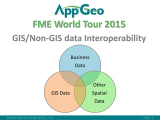
  • 1. © 2 0 1 5 A p p l i e d G e o g r a p h i c s , I n c . S l i d e 1 FME World Tour 2015 GIS/Non-GIS data Interoperability Business Data Other Spatial Data GIS Data
  • 2. © 2 0 1 5 A p p l i e d G e o g r a p h i c s , I n c . S l i d e 2 Data Overwhelms
  • 3. © 2 0 1 5 A p p l i e d G e o g r a p h i c s , I n c . S l i d e 3 CADD Data Requires Processing
  • 4. © 2 0 1 5 A p p l i e d G e o g r a p h i c s , I n c . S l i d e 4 Conceptualize Process FME ROW Geospatial Data Process Geometry Georeference Images Convert Objects to Features Create Features from Image MicroStation DGN file Scan Features Georef. Scan Archive JP2 Georeferenced
  • 5. © 2 0 1 5 A p p l i e d G e o g r a p h i c s , I n c . S l i d e 5 Define Business Objective Project Areas Plats VTrans ROW Map Viewer ROW Geospatial Data VTrans DGN DGN DGN DGN DGN DGN CADD to GIS Conversion Vermont Base Map Data PPMS For Selected Project: PPMS & Artemis Attributes Project #, Project Description, Project History, CADD DGN filename & location, Etc. Scan Scan Artemis Artemis Project View Artemis Project View PPMS UIPPMS UI OnBase Muni Parcel Data Linear Referencing Road Centerlines Town Boundaries Ortho Imagery Utility ACQ. OnBase Doc Mgmt OnBase Doc Mgmt Sell-off
  • 6. © 2 0 1 5 A p p l i e d G e o g r a p h i c s , I n c . S l i d e 6 Integrated Data Viewers
  • 7. © 2 0 1 5 A p p l i e d G e o g r a p h i c s , I n c . S l i d e 7 Establish Business Workflow
  • 8. © 2 0 1 5 A p p l i e d G e o g r a p h i c s , I n c . S l i d e 8 Develop Repeatable Models • Interop Extension • FME models • Python scripts • Bentley Map
  • 9. © 2 0 1 5 A p p l i e d G e o g r a p h i c s , I n c . S l i d e 9 Enable End User Action
  • 10. © 2 0 1 5 A p p l i e d G e o g r a p h i c s , I n c . S l i d e 1 0 Hide Tool Complexities
  • 11. © 2 0 1 5 A p p l i e d G e o g r a p h i c s , I n c . S l i d e 1 1 Invoke FME Workbench From OS Private Sub RunSelectedToolButton_Click() Dim ShellCommand As String Dim SubFormRecordSet As Recordset ShellCommand = "C:program filesFMEfme.exe " & Chr(34) & "C:gitcdot_2012- 0228.interoperabilityfmw" & Me.ToolNameCombo.Column(2) & Chr(34) Set SubFormRecordSet = Me.ToolParameter_subform.Form.Recordset If Me.ToolParameter_subform.Form.Recordset.RecordCount > 0 Then SubFormRecordSet.MoveFirst Do While Not SubFormRecordSet.EOF ShellCommand = ShellCommand & " --" & SubFormRecordSet!ParameterName & " " & Chr(34) & SubFormRecordSet!Value & Chr(34) SubFormRecordSet.MoveNext Loop End If Call Shell(ShellCommand, vbMaximizedFocus) End Sub
  • 12. © 2 0 1 5 A p p l i e d G e o g r a p h i c s , I n c . S l i d e 1 2 Retain Source Info Drawing Area Attributes PK OBJECTID pin source_file source_path source_type source_date method quality projection offset unit_of_resolution units_master units_sub accuracy resolution plan_scale SHAPE SHAPE_LENGTH SHAPE_AREA vtrans_row.gdb features areas project drawing bridge_point bridge_line control_point control_line drainage_point drainage_line landscape_point landscape_line mapping_point mapping_line other_point other_line pavement_point pavement_line roadway_point roadway_line Feature Attributes PK OBJECTID SHAPE pin object_modified_date source_file source_path source_level_number source_level_description source_level_name level_number level_name level_description annotation_label cell_name tag_name tag_description tag_x style color weight SHAPE_LENGTH (lines only) Drawing Areas Feature Class Attributes Common Features Feature Class Attributes Project Area Attributes PK OBJECTID pin project_completion_date Project Areas Feature Class Attributes Feature Level Metadata Create Backdrop Features Level to Feature Mapping & Filtering
  • 13. © 2 0 1 5 A p p l i e d G e o g r a p h i c s , I n c . S l i d e 1 3 • You have to understand the data – English, Metric – Scans, tiffs – Survey points or ROW lines – Quality & accuracy – Vintages/standards • Data mgmt. best practices provide structure – On-going, scalable, repeatable, documented • Workflows – The operations and methods performed on data • Lifecycle – The stages of the data as it flows Interoperability is not a one time thing It’s really about the Process
  • 14. © 2 0 1 5 A p p l i e d G e o g r a p h i c s , I n c . S l i d e 1 4 Understand Lifecycle Collect Maintain Publish ValidateTransform Catalog Archive Retire Analyze Analyze Integrate Refresh Produce Consume
  • 15. © 2 0 1 5 A p p l i e d G e o g r a p h i c s , I n c . S l i d e 1 5 Accomplish the Goal