1. Sensors and Their Specifications
Wide Field Sensor
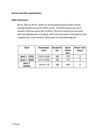
IRS-1C, IRS-1D, IRS-P3, which are all second generation Indian remote
sensing satellites,carried the WIFS sensor. The WIFS camera uses an 8
element refractive optics like in LISS-III. Two such cameras are mounted
with overlapping pixels of imaging. WIFS data was used in assesment of rabi
cropped area, crop inventory, observation of crop phenology etc.
Band Wavelength Resolution Swath Revisit time
(µm) (m) Width (days)
(km)
Band 1 (VIS) 0.62 to 0.68 188 774 5
Band 2 (NIR) 0.77 to 0.86 188 774 5
Band 3
1.55 to 1.75 188 804 5
(SWIR)
S K Diwakar