Monitoring the Levees: GITR 2010
•Télécharger en tant que PPTX, PDF•
1 j'aime•561 vues

This was my presentation given at GIS in the Rockies 2010 on monitoring the levees of Sacramento. I cover some history of the levees and flooding and talk about what's been done and the GIS side of the monitoring.

Recommandé
Recommandé
Contenu connexe
Similaire à Monitoring the Levees: GITR 2010
Similaire à Monitoring the Levees: GITR 2010 (13)
Monitoring the Levees: GITR 2010
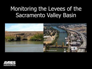
- 1. Monitoring the Levees of the Sacramento Valley Basin
- 2. Sacramento River Basin City of Sacramento San Joaquin Basin San Francisco Los Angeles
- 7. 1850: First major flood hits Sacramento
- 8. 1861: Largest flood in California history
- 11. 1940s: 90% of current system completeYuba City - 1955
- 12. 1986 Flooding “My question – and I ask this without ever having seen Pacific Storm Bob or whatever it’s called – [is] why do we have three days of front page stories and TV news stories about a rainstorm? Is it because Californians are sissies?” - San Francisco columnist
- 13. 1986 Flooding In response, after the storm: “Nature in California is a smiling killer that can turn on you at any time.” - Carl Nolte (SF colleague)
- 14. 1986 Flooding Tyler Island
- 15. 1986 Flooding
- 16. 1986 Flooding
- 17. “Afterwards, if one were to take statistical probability as a guide, there was every reason to believe we would not see another flood of that magnitude for many years…” - David Kennedy, former Director of CA DWR (quoted from his forward to Battling the Inland Sea)
- 21. “And yet, only eleven years later, the January 1997 flood produced flows on several major streams , such as the Feather and Yuba rivers, some 20 percent greater than 1986.” - David Kennedy, former Director of CA DWR (quoted from his forward to Battling the Inland Sea)
- 22. Impact of 1997 Flooding Annual erosion inventory (USACE Sac District) Hydrographic Survey of System & Hydraulic Modeling Emergency fixes and maintenance efforts Repair work (limited to only 5 sites!)
- 23. June 3, 2004 Jones Tract (Delta)
- 24. August 29, 2005
- 25. August 29, 2005
- 26. January, 2006 LEVEES FINAL GRADE: D
- 27. January, 2006
- 29. February, 2006 A State of Emergency is declared for the Central Valley levees and emergency repairs proceed.
- 31. Paper to digital (Trimble GeoXT/XH)
- 32. Erosion Sites File Geodatabase (GDB)
- 36. Why? ArcPad 6-7 weaknesses
- 37. Buggy
- 38. Small viewing window cluttered by toolbars
- 39. Form builder difficult to use
- 40. Not as intuitive as Terrasync
- 41. Known issue with Terrasync: How would it work with a GDB?
- 43. ArcPad 6/7 to ArcPad 8
- 45. The Winner: ArcPad 8
- 46. Upper Bank Middle Bank Lower Bank Toe Observed Attributes Erosion Location Bank Slope/Berm Width Underwater
- 47. Example: Soils
- 53. Over 70 sites repaired since 2006!
- 54. Multiple agencies working together!
Notes de l'éditeur
- This is the infamous central valley of California. Notice how flat and extensive it really is. There’s a reason that when the first settlers came here they called it “The Inland Sea.” The northern part of the valley is the Sacramento River basin while to the south is the San Joaquin Basin. The total population of the valley is about $6.5M.
- Here is the Sacramento Valley, population roughly 2.5 million. The pink lines are the levee system. You can see Tahoe to the right.
- Now we see the City of Sacramento. Again, you can see the levee systems. Let me explain the complexity just a little bit – a few of the bypasses, the rivers and such. You can see the area and the density of population that these levees protect.
- Levee breaks occurred at Olivehurst, Linda, Thornton, and 4 delta islands. Lake Tahoe actually rose 6 inches from this storm alone!
- Personally, as an engineer who has some experience with bridge scour and how bridge foundations can be eroded in a high flow, that is the last place I would want to be standing!
- A lot of damage! All in all: 13 people killed and 50,000 evacuated. In some areas it was a 1000yr precipitation event.
- After the 1986 flood, this is what people were thinking…
- There were dozens of breaks in the levee system on the San Joaquin and roughly half a dozen in the Sacramento basin. 300 sq miles were flooded.
- 23,000 homes, businesses, bridges, roads, and flood management infrastructures were damaged.
- All in all, 9 more people were killed and over 120,000 people were evacuated.
- The erosion inventory covers 300 miles of river and an additional 300 miles of bypasses which are only completed when flow dictates. The hydrographic survey data is still their standard bathymetric data in use to this day. By emergency fixes and maintenance, I mean basically dumping rock off the side of the levee. We’ve been involved with the inspections since the beginning. Can anyone take a guess as to why the repair work was limited to only 5 sites? It was mainly due to environmental and endangered species concerns.
- However, this issue just keeps building after 1997.
- Then this happens.
- An unbelievable tragedy that New Orleans has only somewhat recovered from to this very day.
- The events of Hurricane Katrina and New Orleans triggered a number of things including this report card.
- People started to put the pieces together with regard to the Sacramento levee system.
- Again, slowly putting the pieces together. This area shown is a prime development area and there’s actually been a ton of controversy here over the decertification of the levees and finding money to fix it. The nickname that we have for this area? The Natomas Bath Tub.
- It all leads up to this. Arnold declaring an emergency and kicking emergency repairs in gear. This gets us roughly to the present and bit of what we did last year.
- As I mentioned before, we’d been involved in the inspections since 1997 but prior to this, we only submitted hard copies of the Atlas and Final Report with the Site Priority Rankings. We had the erosion sites in a geodatabase since we started doing the Atlas, it was just never a formal submittal. We gave it to the Corps as a bonus. In 2009, we finally convinced them to push more in the digital direction and formalize the database.
- Terrasync: really easy, really intuitive. The data dictionary builder is fast and on the Trimble it’s easy to pick up and learn. The limitations: working with a file geodatabase, number of vectors and aerials, a lot less options with your forms.
- The Corps and myself also did not have a favorable impression of ArcPad 6 or 7 and neither did I for that matter. Between the bugs and crashes and lack of screen space, it needed improvement. Prior to ArcPad 8 being released I was actually taking a good look at CartoPac, especially since I had friends that worked there but there was one small feature that we really needed that it did not have. But then ArcPad 8 was released and it was what we tested on this project. It was loads better. Smoother, more screen space, a huge upgrade.
- The form development for ArcPad using Studio was still not as simple as Terrasync and that still was one downer but it really proved to be straightforward even with almost no programming experience and we were able to develop a nice 5 page form.
- Once we did the test run in the field to decide if it were to be Terrasync over ArcPad 8, ArcPad 8 won easily and the Corps were impressed with the form and the improvements. Here’s a little snapshot of the levee inspection form.
- There are about 40 observed attributes for each erosion site! I wanted to just illustrate a few of them for you.
- The higher the score the worse
- A few shots of the actual inspection. As you can see it’s by boat, completely waterside. Not dealing with geotechnical issues or new seepage issues.
- One of the final deliverables besides the database and report and rankings is the atlas. This is probably the most demanded and useful piece although we’ve proposed and pushed for more of an online system – which is likely one of the next steps.
- It would take about $42 billion more to get the system to where it needs to be.