Soumettre la recherche
Mettre en ligne
iOne Geoimaging Scalable Sensors Automated Workflow
•
0 j'aime
•
244 vues
Titre amélioré par l'IA
Armando Guevara
Suivre
Geoimaging the world online
Lire moins
Lire la suite
Signaler
Partager
Signaler
Partager
1 sur 2
Télécharger maintenant
Télécharger pour lire hors ligne
Recommandé
Unmanned Aerial Systems (UAS) Data Quality and Accuracy Realities
UAS Colorado
Digital Orthophotography Production
kongphooey
UAS Applications for Civil Engineering
UAS Colorado
Brosure Laser 4D Monitoring Systems 3DLM UK Jogja
Murabet, MRT
Sundt - Laser Scanning
Alan Sanoja
FlightPath_ServiceSheet_050516_FNL
dkinpdx
Multi Limn Leica Hds Conference 2009
timbeach
Prospecting for Profits with GIS
Greg Babinski
MineExcellence - drones platform for mining industry
Mason Taylor
ScanMapBrochure2016_loRES
John Taylor
presenter_mobilemapping_highways_HQ_print
Steve Jones
Laser Scanning: The Future Trend
Fishbeck, Thompson, Carr & Huber, Inc.
2018 GIS in the Rockies Vendor Showcase (Wed): Laser GIS for Everyone Elimina...
GIS in the Rockies
How Python can Build Links Between Erdas Imagine’s Spatial Modeller and FME D...
Safe Software
UAV MAPPING, LIDAR MAPPING, LAND AND MINING AND ENGINEERING SURVEY - TES
Brett Johnson
Remote Sensing Using an Airborne Biosensor
Angelo State University
Adapting remote sensing research for environmental monitoring: Citizen mappin...
FOSS4G 2011
Airborne Remote Sensing of Institute for Environmental Solutions
Institute for Environmental Solutions (IES)
Airbone platform
Airbone platform
Sumant Diwakar
What happens when we read for visual thinking, narration, and explanation jun...
Angelo State University
ARGOMARINE Final Conference - NTUA Presentation - Vassilia Karathanassi, Pol ...
ARGOMARINE
Nexvision corporate presentation
NEXVISION SAS
PCI Geomatics Synthetic Aperture Radar Processing Capabilities
Pci Geomatics
Perceiving and understanding the world for ADAS and Autonomous _Peter Labazie...
Peter Labaziewicz
Inspection of Suspicious Human Activity in the Crowd Sourced Areas Captured i...
IRJET Journal
SoftKinetic
SoftKinetic
imec
UWB precision location system
Echo Wang (IoT antenna,cable,connector)
Machine Vision Systems And Applications
Francy Abraham, MSEE, MBA
Facet technology 4DFlash(tm) vision sensor for vehicles
John Dolejsi
PCI Geomatics Overview
Pci Geomatics
Contenu connexe
Tendances
MineExcellence - drones platform for mining industry
Mason Taylor
ScanMapBrochure2016_loRES
John Taylor
presenter_mobilemapping_highways_HQ_print
Steve Jones
Laser Scanning: The Future Trend
Fishbeck, Thompson, Carr & Huber, Inc.
2018 GIS in the Rockies Vendor Showcase (Wed): Laser GIS for Everyone Elimina...
GIS in the Rockies
How Python can Build Links Between Erdas Imagine’s Spatial Modeller and FME D...
Safe Software
UAV MAPPING, LIDAR MAPPING, LAND AND MINING AND ENGINEERING SURVEY - TES
Brett Johnson
Tendances
(7)
MineExcellence - drones platform for mining industry
ScanMapBrochure2016_loRES
presenter_mobilemapping_highways_HQ_print
Laser Scanning: The Future Trend
2018 GIS in the Rockies Vendor Showcase (Wed): Laser GIS for Everyone Elimina...
How Python can Build Links Between Erdas Imagine’s Spatial Modeller and FME D...
UAV MAPPING, LIDAR MAPPING, LAND AND MINING AND ENGINEERING SURVEY - TES
En vedette
Remote Sensing Using an Airborne Biosensor
Angelo State University
Adapting remote sensing research for environmental monitoring: Citizen mappin...
FOSS4G 2011
Airborne Remote Sensing of Institute for Environmental Solutions
Institute for Environmental Solutions (IES)
Airbone platform
Airbone platform
Sumant Diwakar
What happens when we read for visual thinking, narration, and explanation jun...
Angelo State University
ARGOMARINE Final Conference - NTUA Presentation - Vassilia Karathanassi, Pol ...
ARGOMARINE
En vedette
(6)
Remote Sensing Using an Airborne Biosensor
Adapting remote sensing research for environmental monitoring: Citizen mappin...
Airborne Remote Sensing of Institute for Environmental Solutions
Airbone platform
Airbone platform
What happens when we read for visual thinking, narration, and explanation jun...
ARGOMARINE Final Conference - NTUA Presentation - Vassilia Karathanassi, Pol ...
Similaire à iOne Geoimaging Scalable Sensors Automated Workflow
Nexvision corporate presentation
NEXVISION SAS
PCI Geomatics Synthetic Aperture Radar Processing Capabilities
Pci Geomatics
Perceiving and understanding the world for ADAS and Autonomous _Peter Labazie...
Peter Labaziewicz
Inspection of Suspicious Human Activity in the Crowd Sourced Areas Captured i...
IRJET Journal
SoftKinetic
SoftKinetic
imec
UWB precision location system
Echo Wang (IoT antenna,cable,connector)
Machine Vision Systems And Applications
Francy Abraham, MSEE, MBA
Facet technology 4DFlash(tm) vision sensor for vehicles
John Dolejsi
PCI Geomatics Overview
Pci Geomatics
Icaros Photogrammetric Suite (IPS) Module Overview
IcarosMapping
Maps Across Texas
Maps Across Texas
Texas Natural Resources Information System
AXONIM 2017 UAV embedded solutions
Vitaliy Bozhkov ✔
Unconstrained Activity Recognition in an Office Environment
Christopher Ramirez
PS_Unconstrained_Activity
Parker Sankey
OMG DDS: The data centric future beyond message-based integration
Gerardo Pardo-Castellote
Human Motion Detection in Video Surveillance using Computer Vision Technique
IRJET Journal
The ione infrastructure metric mapping system (ims) armando guevara
Armando Guevara
Aerial Services, Inc
Aerial Services
How AI is DisruptingTraffic Management in Smart City
Jorge Sebastiao
Lessons learned building a big data analytics engine, from proprietary to ope...
J On The Beach
Similaire à iOne Geoimaging Scalable Sensors Automated Workflow
(20)
Nexvision corporate presentation
PCI Geomatics Synthetic Aperture Radar Processing Capabilities
Perceiving and understanding the world for ADAS and Autonomous _Peter Labazie...
Inspection of Suspicious Human Activity in the Crowd Sourced Areas Captured i...
SoftKinetic
SoftKinetic
UWB precision location system
Machine Vision Systems And Applications
Facet technology 4DFlash(tm) vision sensor for vehicles
PCI Geomatics Overview
Icaros Photogrammetric Suite (IPS) Module Overview
Maps Across Texas
Maps Across Texas
AXONIM 2017 UAV embedded solutions
Unconstrained Activity Recognition in an Office Environment
PS_Unconstrained_Activity
OMG DDS: The data centric future beyond message-based integration
Human Motion Detection in Video Surveillance using Computer Vision Technique
The ione infrastructure metric mapping system (ims) armando guevara
Aerial Services, Inc
How AI is DisruptingTraffic Management in Smart City
Lessons learned building a big data analytics engine, from proprietary to ope...
Plus de Armando Guevara
Towards an adaptable spatial processing architecture
Armando Guevara
On the evolution of gis and the spatial enabling of information armando gue...
Armando Guevara
On kps kilo pixel swath - asprs - armando guevara
Armando Guevara
The future of oblique and 3 d mapping for city planning and management tren...
Armando Guevara
The arca of iris one asprs 2009 armando guevara
Armando Guevara
The visual intelligence iris one airborne digital camera systems petrie geo...
Armando Guevara
A new generation of geoimaging sensors is poised to change the geoimaging ind...
Armando Guevara
Sensors for a multi purpose world - armando guevara - sensors and systems
Armando Guevara
The Science of Where
Armando Guevara
The i one ims v-iisual intelligence technical white paper - armando guevara
Armando Guevara
On kps kilo pixel swath - asprs - armando guevara
Armando Guevara
iOne STKA Technology Innovation Forum - The Science of Where 5.16.13
Armando Guevara
The spatial enabling of information logo
Armando Guevara
The arca of iris one
Armando Guevara
On the spatial enabling of information paradigm locational future - vi
Armando Guevara
Towards and adaptable spatial processing architecture
Armando Guevara
On the-design-of-geographic-information-system-procedures
Armando Guevara
On the spatial enabling of information paradigm rev 06
Armando Guevara
Plus de Armando Guevara
(18)
Towards an adaptable spatial processing architecture
On the evolution of gis and the spatial enabling of information armando gue...
On kps kilo pixel swath - asprs - armando guevara
The future of oblique and 3 d mapping for city planning and management tren...
The arca of iris one asprs 2009 armando guevara
The visual intelligence iris one airborne digital camera systems petrie geo...
A new generation of geoimaging sensors is poised to change the geoimaging ind...
Sensors for a multi purpose world - armando guevara - sensors and systems
The Science of Where
The i one ims v-iisual intelligence technical white paper - armando guevara
On kps kilo pixel swath - asprs - armando guevara
iOne STKA Technology Innovation Forum - The Science of Where 5.16.13
The spatial enabling of information logo
The arca of iris one
On the spatial enabling of information paradigm locational future - vi
Towards and adaptable spatial processing architecture
On the-design-of-geographic-information-system-procedures
On the spatial enabling of information paradigm rev 06
iOne Geoimaging Scalable Sensors Automated Workflow
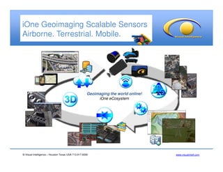
1.
© Visual Intelligence
– Houston Texas USA 713.917.8300 www.visualintell.com iOne Geoimaging Scalable Sensors Airborne. Terrestrial. Mobile. Geoimaging the world online! iOne eCosystem
2.
© Visual Intelligence
– Houston Texas USA 713.917.8300 www.visualintell.com iOne Sensors Intelligent Automated Processing Workflow Isis Earth Virtual Frames Ortho Oblique MS 4 Band DSM Stereo 3D Compilation Point Clouds - 3DM Natural Resources Classification Optional input DEM Optional input DEM Raw Imagery Open systems software architecture Project SetupProject Setup Radiometric Adjustment Radiometric Adjustment VF - ATVF - AT Interior & Exterior Orientation Interior & Exterior Orientation Feature ExtractionFeature Extraction Rigorous geometric and radiometric sensor calibration Rigorous geometric and radiometric sensor calibration Metric Products Metric Products Simactive Pix4D Dat/Em PCI
Télécharger maintenant