Global Wildland Fire Forecasting Using Space Technologies
•Télécharger en tant que PPT, PDF•
1 j'aime•775 vues

presentation to the United Nations Committee on the Peaceful Uses of Outer Space (COPUOS) in Vienna, Austria on 23 February 2006
![Global Effects of Fires ,[object Object],[object Object],[object Object],[object Object],Global Fire Map 31 Jan - 9 Feb 2006 NASA MODIS Rapid Response System](data:image/gif;base64,R0lGODlhAQABAIAAAAAAAP///yH5BAEAAAAALAAAAAABAAEAAAIBRAA7)
Recommandé
Recommandé
Contenu connexe
Tendances
Tendances (20)
Similaire à Global Wildland Fire Forecasting Using Space Technologies
Similaire à Global Wildland Fire Forecasting Using Space Technologies (20)
Plus de Brian Shiro
Plus de Brian Shiro (16)
Dernier
Dernier (20)
Global Wildland Fire Forecasting Using Space Technologies
- 1. Global Wildland Fire Forecasting Using Space Technologies Brian R. Shiro NOAA Pacific Tsunami Warning Center Axelle Cartier-Guitz Leiden University / Campus The Hague 23 February 2006 UN COPUOS STSC Vienna, Austria
- 3. FLAMA Mission Statement accessible global information framework “ Our mission is to design an adaptable, that enables regional wildfire forecasting. ”
- 5. Input Parameters Weather Fuel Topography Scientific Parameters Health Services Population Maps City Maps Response Capability Parameters Activity Monitoring Prescribed Burning Economic Activity Camping Tourism
- 7. FLAMA System Design INPUT Airborne Ground Segment Space Segment Open Service Public Service Commercial Service DISSEMINATION PROCESS F L A M A D A T A B A N K Acquisition Acquisition of Data Standardization Integration Activity Monitoring Tool Vulnerability Model Fire Forecasting Model Modeling Fire Probability Map Vulnerability Map Single Parameter Map Output Fire Risk Assessment Raw Data Live Fire Monitoring Comparison Quality Improvement New Systems & Parameters Product Improvement User Satisfaction INPUT Airborne Ground Segment Space Segment PROCESS F L A M A D A T A B A S E Acquisition Data Acquisition Standardization Integration Activity Monitoring Tool Vulnerability Model Fire Forecasting Model Modeling Fire Probability Map Vulnerability Map Single Parameter Map Output Fire Risk Assessment Raw Data Open Service Public Service Commercial Service DISSEMINATION
- 9. Fire Risk Assessment Example Vulnerability High Medium Low No risk Water Water Very Far Far Near Flat Slope Steep Probability High Medium Low Water Past Fire
- 10. Products and Services Availability of Data Security Limitations Registration on Website Registration on Website Limitation Fee Free or At Cost Free via Internet Cost Upon Request Highest Resolution High Resolution Low Resolution General Information Product Private Entities Tourism Industry Insurance Companies Governments Public Institutions Research Institutes Individuals Users Commercial Service Public Service Open Service
- 18. Thank You
Notes de l'éditeur
- Slide 1: Title Slide Thank you, Mr. Chairman. My colleague Axelle Cartier and I will be presenting the results of a team project from this summer’s International Space University Summer Session Program, which was held in Vancouver, Canada. We will speak on the subject of Global Wildland Fire Forecasting Using Space Technologies. <ENTER>
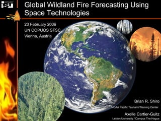
- Slide 2: Global Effects of Fires Over the past decade, many regions of the world have experienced an increasing occurrence of severe wildland fires. The image shown here is a global fire map from NASA’s MODIS Rapid Response System. The map accumulates the locations of the fires detected over a 10-day period from 31 January to 9 February 2006. <ENTER> The effects of wildland fires can cross borders and become international problems. An example is smoke pollution and its impacts on human health and safety. The increasing urban-wildland interface is magnifying the risk of fire to humans as we expand our settlements into wild areas. <ENTER> Each year, upwards of 820 million hectares of Earth’s land burns, consuming an estimated 6.3 billion tons of vegetation and p roducing about 25% of the world’s total greenhouse gas emissions. The depletion of terrestrial carbon by fires is one of the driving agents of the global carbon cycle. <ENTER> Degradation of landscapes triggered by excessive wildland fires can lead to secondary disasters such as flooding, desertification, biodiversity loss, and destabilization of ecosystems. <ENTER>
- Slide 3: FLAMA Mission Statement When our team was first approached to address the challenge of wildland fires, we had complete freedom on the direction we could take. For example, we could have designed a satellite system to locate and track wildfires or to help firefighters quench them. After doing our research we concluded that we didn’t necessarily need more measurements. Instead, we found that the major gaps were greater access to information and the ability to forecast fire vulnerability and behavior. <ENTER> As such, our mission is to design an adaptable accessible global information framework that enables regional wildfire forecasting. Adaptable means having the ability to be tailored to different needs. The system must also be robust to changing data availability and user demands. Accessible refers to reaching everybody, including developing countries, who could use the information. This means the system must be low cost. In order to have a low cost system, FLAMA is a way of fostering cooperation among existing systems, rather than a proposal for a whole new system. Global with respect to this information framework means providing information for all areas around the planet, since the problems associated with wildland fires cross borders. Enabling regional wildfire forecasting means that, when needed, the information being provided will be specific to help local regions. We chose the acronym “FLAMA” to represent our project’s aim. It stands for “ Fire Logistics and Management Approach” and is also a Latin word for “fire.” Keeping this philosophy in mind, the following slide outlines more specifically the needs we wanted to address in terms of information management and fire forecasting. <ENTER>
- Slide 4: Information & Forecasting Needs <ENTER> Information Management needs include: Cooperative sharing of data among nations, both developed and developing. Standardized data formats are needed in order to integrate data from different systems and allow easy sharing of data. Centralized access to data, information, and resources is needed through a user-friendly interface. In terms of transparency the providers need to know who is using their information, and the users need to know who has provided the information. In terms of security, a clearing house is needed to make sure national security concerns are met, particularly with regard to the distribution of high resolution images. <ENTER> Fire forecasting needs include: Integration of social and scientific data in order to better understand our vulnerability to fires. Individuals and fire managers need to have prompt fire risk assessment maps in order to be able to take appropriate actions. Fire forecasting models can be validated using high resolution data after events have happened by going back and trying to predict the same event from historical data. This will lead to the improvement of forecasting models. <ENTER>
- Slide 5: Input Parameters Now I will describe the 3 basic types of input parameters to the FLAMA system. <ENTER> Major scientific parameters include fuels, weather, and topography. Fuels refers to the characteristics of live and dead materials that can burn - their distribution and moisture content, for example. Weather refers to parameters such as temperature, relative humidity, solar radiation, precipitation, lightning, wind speed and direction. Topography includes the slope and elevation of the land, which influences the wind and fire behavior. <ENTER> Response Capability parameters provide information on how efficient the response to a fire would be. Such inputs include population density, city infrastructure maps, and the locations of fire fighting resources, hospitals, and sources of water. <ENTER> Activity monitoring is an innovative tool that will be used in the FLAMA system. While its roots are in the business sector, activity monitoring could provide very valuable information for wildland fire prediction. The basis of activity monitoring is to uncover correlations between parameters that are not often considered initially. For example, how does tourism affect fire risk? Economic activity such as logging, prescribed burning, and other human activities will also help correlate fire risk assessment. It is expected that incorporating this innovative tool into fire forecasting models will lead to improvements in fire forecasting capabilities by providing insights into the links between wildland fires and human-related activities. These three categories of inputs into the FLAMA system provide the vital information to fire forecasting models. <ENTER>
- Slide 6: Use of Space Resources <ENTER> FLAMA relies heavily upon Earth observation satellites in order to obtain the necessary input parameters, which I discussed on the previous slide. <ENTER> Visible, infrared, multispectral, and microwave synthetic aperture radar (SAR) are all useful types of images for wildland fire observation. <ENTER> Satellites in polar low Earth orbits have high spatial resolution but long revisit times. Examples of satellites or instruments of major importance to wildland fire monitoring are shown below: NOAA AVHRR - Advanced Very High Resolution Radiometer Terra/Aqua MODIS, ASTER - Moderate Resolution Imaging Spectroradiometer, Advanced Spaceborne Thermal Emission & Reflection Radiometer TRMM VIRS - Tropical Rainfall Measuring Mission Visible & Infrared Scanner ERS-1,2 ATSR, SAR - Along Track Scanning Radiometer, Synthetic Aperture Radar ENVISAT AATSR, MERIS - Advanced Along Track Scanning Radiometer, Medium Resolution Imaging Spectrometer SPOT VGT - VEGETATION LANDSAT TM, ETM+ - Thematic Mapper, Enhanced Thematic Mapper Plus BIRD - Bispectral Infrared Detection <ENTER> Satellites in geostationary orbits have the advantage of a large viewing area and shorter revisit times. Satellites and instruments of importance to wildland fire monitoring are shown below: GOES-9/10/12 (NOAA) - ABBA = Automated Biomass Burning Algorithm MSG SEVIRI (European) - Spinning Enhanced Visible & Infrared Imager MTSAT-1R JAMI - Japanese Advanced Meteorological Imager <ENTER>
- Slide 7: FLAMA System Design The FLAMA System consists of input information, a geographical information system (GIS) database, fire forecasting models, and output information products. <ENTER> Raw data is acquired to produce input information from research and operational space-based instruments. This is complemented with data from airborne and ground sensors, as well as historical data. <ENTER> The input information is checked for reliability and standardized by geo-referencing them to a common frame of reference. These are then stored as layers in a GIS structured database. Fire forecasting and vulnerability models take the different layers of information and integrate them into three-dimensional fire risk assessment maps. We propose the forecasting models of FLAMA to be based on the Canadian Forest Fire Danger Rating System (CFFDRS), which is currently in use in many countries (New Zealand, Alaska, Sweden, Argentina, Mexico, Europe, Southeast Asia). Both the input information and the products of the models are maintained in an archive, which we estimate would fill at a rate of 6 terabytes per year. The FLAMA system’s main outputs are geographical fire vulnerability and probability maps. This information is visualized in a GIS format whereby the model layers are combined with topographical and other single parameter information to show the likelihood of fire ignition in a specific region, the forecasted intensity of such a fire, the damage the fire might cause, the difficulty in controlling the fire, and the local infrastructure and response capabilities. Social, economic, and cultural factors are included through the activity monitoring tool, which I discussed on an earlier slide. <ENTER> The maps are available in different scales and resolutions, and provide different parameters depending on user demands. We propose 3 separate end-user services, which will be described in more detail later. <ENTER> The difference between forecasted and actual fire behavior is quantified and fed back into the system to calibrate and improve the fire forecasting models. User feedback and input from the scientific community also helps to improve the system. <ENTER>
- Slide 8: Output Products The FLAMA system provides three main outputs including single parameters maps, fire probability maps, and fire vulnerability maps. Single parameter maps are relatively simple outputs comprised of an input parameter derived from raw data. Examples include temperature and soil moisture maps. Fire probability maps receive inputs from single parameters. These maps provide information on the likelihood of a fire starting, whether due to human or natural causes. Fire vulnerability maps includes information on roads, water resources, human population, etc. The basis of a vulnerability map is to provide information on the difficulty a fire ignition would present and what danger it would pose to local populations. Fire managers can combine fire probability and vulnerability maps are to form an overall fire risk assessment. As a result of the large amount of data that is collected in the FLAMA system database, some additional products may be produced. Examples of such additional products include carbon dioxide monitoring for the Kyoto Protocol, detection and monitoring of biomass burning and volcanic eruptions, and change detection maps. The latter would be produced by taking the difference of two images of the same area at different times. These maps could be used to study the evolution of land cover due to deforestation, human infrastructures, vegetation changes, etc. FLAMA products could help in a variety of environmental and economic areas in addition to solely dealing with wildland fires themselves. <ENTER>
- Slide 9: Fire Risk Assessment Example Fire risk refers to the combination of fire danger and fire vulnerability. Fire danger is related to the probability of fire ignition and propagation. Fire vulnerability refers to the outcome and consequences of the fire. A risk assessment is an organized look at what could cause harm, and this allows fire managers to decide whether enough precautions have been taken to avoid damages. This images shows the Victoria region, which is on the southern tip of Vancouver Island off the west coast of British Columbia, Canada. <ENTER> This can be overlain by a fire probability map showing the relative likelihood of fire ignition in different areas along with the locations of past fires that have occurred. <ENTER> Slope is derived from digital elevation models of the topography. Slope is important because it can affect wind direction and how fires spread. <ENTER> The proximity to nearby water sources is another layer that can be viewed and incorporated into the fire risk assessment. <ENTER> The location of Infrastructure such as major roads can be viewed as another layer in the GIS. <ENTER> All of this information is then fed into fire forecasting models to predict fire vulnerability. <ENTER> Again, layers such as roads can be turned on or off according to the user’s needs. <ENTER> Now I would like to introduce Axelle Cartier who will be giving the remainder of the presentation. <ENTER>
- Open Service: Low resolution fire probability maps for public awareness; FLAMA’s value-added information is distributed to the users with no copyright restrictions through the Open Service (after a standard contract requiring an online registration; free of charge). Public service: Also for forestry department, university … on Fire Risk Assessment Also Maps on single parameter Information provided at a cost under a standard contract Commercial Service: for the requests to meet the particular needs of the private sector Non continuous, on specific request Will Subsidize the OS Commercial service and FLAMA NGO Not for profit organizations can engage in legally permitted activities which are not primarily intended to make profits. The money should support the non-profit activities to which the NGO is dedicated at.
- Grant - Loans World Bank: According to the Operational Manual of the World Bank, the WB interacts with two main categories of NGOs: -advocacy NGOs (defending a specific cause: CARE for eg.) -operational NGOs: whose primary purpose is the design and implementation of development-related projects. FLAMA-World Bank: operational basis. Other Development Banks: European Investment bank, Inter American Intl Bank ISDR: The UN International Strategy for Disaster Reduction (UN ISDR) provides funding for projects involved in alleviation of the impact of disasters. As an illustration, the ISDR has already distributed 10 million dollars to facilitate the implementation of the tsunami early warning system in the Indian Ocean. The FLAMA system fits with the scope of the ISDR. World Bank BioCarbon funds: The World Bank also provides funding through its “Carbo finance programmes”, dedicated to the financing of projects aiming at reducing the carbon emissions. The BioCarbon Funds have been mobilized to demonstrate projects that reduce greenhouse gas concentrations by sequestering or conserving carbon in forest. The Fund started operations in May 2004 and has a capital of $51.3 million as of June 2005. DIPECHO The European Commission’s humanitarian aid department (ECHO) has a Disaster Preparedness programme (DIPECHO) which targets vulnerable communities living in the main disaster-prone regions of the world. Private customers/donations: Traditional, reliable and powerful source of funding for not-for-profit NGOs.
- Idea: there are many instruments out there; let us use them.
- Also, Principles on Remote Sensing and other outer space treaties as outlined in the FLAMA report. All these relevant Global Conventions take years to implement.
- Non-binding under international law Formal, approved and binding instrument: responsibility of the international community (adoption of standards) See idea of safety and security (ICAO SARPs and Annexes C44)
- NGOs are not established under international law, and do not result from an international treaty like international organizations. International organizations have a complex structure; treaties (drafting, signature, ratification, implementation): a rather long process.
- FLAMA INNOVATIONS “ One-stop shop” Rather than having to know exactly what data source you need and search all over the Internet to find it, FLAMA users enjoy centralized access to data and information in a “one-stop shop.” Activity monitoring As Boris mentioned earlier, “Activity monitoring” is an aspect of the FLAMA modeling strategy whereby scientific, socioeconomic, and other seemingly unrelated data are monitored over time to uncover new predictive relationships. Feedback from users Since FLAMA services are user-driven, it relies on the incorporation of cutting edge scientific models and techniques as well as local knowledge and traditional practices. This feedback continually improves the FLAMA system. Global scope with Local sensitivity With its vantage point from space-based technologies and international agreements, FLAMA is global in its scope. At the same time, FLAMA tailors itself to local needs. It involves local communities in fire management to give them a sense of ownership on the wildfire problem and provides relevant information to developing and developed countries alike. FLAMA ADVANTAGES The advantages of FLAMA include its Integrated approach to: Information assimilation from many sources; Information creation of value-added fire risk and vulnerability assessment products through innovative modeling techniques; and Information dissemination with a GIS approach to centralized access. FLAMA is managed by a non-governmental organization and provides 3 levels of service: open, public, and commercial. Decision support tool FLAMA provides information to support decision makers in both everyday and emergency situations. This can help reduce risk to human health and property. Convenience There are many existing systems, but there is a great need for improved communication and interoperability among them. No one system or website integrates all the relevant information for wildfires. FLAMA’s centralized information access portal makes it easier and more convenient to find the information you need. Low cost By utilizing all existing systems and incorporating new ones as they become available, FLAMA minimizes its costs. Partnerships with experts in science and industry further help spread out the cost. Conclusions: FLAMA is a global management and fire forecasting system based on a Geographical information system (GIS) architecture. It integrates interdisciplinary fire related information (from space, land and air based sources), including scientific local and human activity information. Those data are applied in advanced models to provide fire probability and vulnerability maps. These two maps are combined to provide a comprehensive fire risk assessment map.
- Slide 17: Looking Forward In the future, FLAMA will evolve to meet changing needs. All phases of forest fires As new technologies and information sources become available, FLAMA will incorporate them. Since it incorporates large volumes of information, FLAMA could expand its scope to include, for example, fire detection, early warning, and post-fire burn analysis. Distributed information network In order to handle the huge volumes of data that will be generated in coming years, scientists will require routine access to models, data, and computing resources from locations distributed around the world. Information technology advances will automate these processes, and FLAMA will adapt to these new information architectures as they emerge. Other natural disasters The FLAMA approach could be adapted for use in other natural disasters such as earthquakes, volcanoes, and hurricanes. There is a strong demand in the world right now for a global disaster information network. FLAMA could play an important role in fostering the development of such a system. International cooperation FLAMA aims to incorporate itself into emerging global cooperative frameworks such as the Global Earth Observation System of Systems and Europe’s Global Monitoring for Environment and Security programs. With international agreements such as the Kyoto Protocol now in force, FLAMA could facilitate carbon dioxide monitoring and trading.
- Slide 18: Thank You 28 students from 15 different countries participated in the FLAMA team project in International Space University’s 2005 Summer Session Program located on the University of British Columbia campus in Vancouver, Canada. Our team’s primary advisor was Dr. Vern Singhroy of the Canada Centre for Remote Sensing. We would like to extend a special thank you to the UN Office of Outer Space Affairs and all distinguished delegates of the COPUOS. This concludes our presentation. There are some brochures on the programs of International Space University at the back of the room. Please feel free to take one on your way out. Thank you, Mr. Chairman, for allowing us to speak today.