Top Rated Pune Call Girls Saswad ⟟ 6297143586 ⟟ Call Me For Genuine Sex Serv...
Media plan
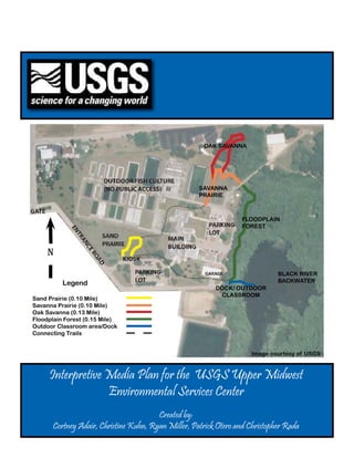
1. OAK SAVANNA
SAVANNA
PRAIRIE
FLOODPLAIN
FOREST
N
BLACK RIVER
Legend BACKWATER
DOCK/ OUTDOOR
CLASSROOM
Sand Prairie (0.10 Mile)
Savanna Prairie (0.10 Mile)
Oak Savanna (0.13 Mile)
Floodplain Forest (0.15 Mile)
Outdoor Classroom area/Dock
Connecting Trails
Image courtesy of USGS
Interpretive Media Plan for the USGS Upper Midwest
Environmental Services Center
Created by:
Cortney Adair, Christine Kuhn, Ryan Miller, Patrick Otero and Christopher Rada
2. Table of Contents
Introduction
University of Wisconsin-Stevens Point undergraduate students Courtney Adair, Christine Kuhn,
Planning Triangle Outdoor Classroom/Dock Signage
Ryan Miller, Patrick Otero, and Chris Rada developed this plan as a part of their Interpretive Media
Mission and Goals The World Underwater course. This plan is being developed for the Upper Midwest Environmental Services Center, or UMESC,
located in Lacrosse, WI. The UMESC is a research center for the United States Geologic Survey, or
Audience A Waterfull World! USGS. The UMESC site is located on the backwaters of the Mississippi River. The site has a variety of
natural habitats, including prairies, river backwaters, an oak savanna, and forests. On the site, there is
Resources
Recommendations a trail system and an outdoor learning center. The trail system and outdoor learning center have some
interpretive media on them, but can be developed much further. This plan is being developed to update
Themes Photography Credits some existing interpretive media on the site and to develop new media to enhance the educational
opportunities at the UMESC.
Conceptual Media Designs
Environmental Interpretive Trails
Sand Prairie Signage
Overflowing with Life
Fire! Fire! Fire!
Savanna Prairie Signage
Abundance of Life and Beauty
Human Reliance on Plentiful Prairies
Oak Savanna Signage
Oak Savannas, the Last Stronghold
Animals of the Oak Savanna
Floodplain Forest Signage
In the Air and Down Below
Land Structure and Protection
USGS Upper Midwest Environmental Sciences Center Interpretive Plan USGS Upper Midwest Environmental Sciences Center Interpretive Plan
2 3
3. The Planning Triangle Planning Triangle continued
Why? Mission:
We are using this part of the triangle to discover the intentions of our chosen organization, and the
Why? reason that it exists. Questions such as: Who are we? (referring to our team and the organization), what
do we do?, who do we do it for?, and why do we do it?, are all questions that this section of the triangle
Mission represent. Meeting with the USGS center and discovering the qualities and components of them will help
form these questions.
Who? Visitor:
How? When? Where? Next, is the section for which the facility works with, the public. Understanding the visitor’s needs
and wants when visiting the UMESC and what they hope to experience or accomplish will help the facility
to gain access to how we can conform to their anticipated outcomes. The visitor is a vital component in the
triangle as well as for the well-being and stability for the facility.
Who? Interpretive What?
Visitor Master Resources What? The Site:
Plan
The UMESC is the medium by which the visitor can make their emotional, intellectual and behavioral
connections to their environment. With the right components to aid them in the own personal enlightenment
with themselves and their surroundings, the various sites at the facility will facilitate these connections with
the use of media and connectedness. We will integrate our own knowledge into these sites to accomplish this
goal.
Our media plans are based off of an organized triangle that asks 3 questions that will unify
our conceptual plan for our site: The Why? (our mission for the site), the Who? (who are the visitors, These three components, the why, who and what will form a conceptual plan that will hopefully be
what do they hope to gain), and the What? (the site and its aspirations). These three components will used at the environmental center to bestow the knowledge of the natural world to the public, and stimulate
allow our team to develop a media plan that will stimulate our visitor’s emotionally, intellectually more people to act in regards to it.
and behaviorally to actively engage in the experience that the Upper Midwest Environmental Science
Center wants to provide for the public. We hope to catalyze the involvement of the visitor using
the Upper Midwest Environmental Center combined with the developed media as a channel for
realization that the environment is an intricate part of the public’s life.
Planning Triangle Photograph Citation:Gross, M. & Zimmerman, R. (2002). Interpretive Centers: The history, design and development
of nature and visitor centers. Stevens Point, WI: UW-SP Foundation Press, Inc.
USGS Upper Midwest Environmental Sciences Center Interpretive Plan USGS Upper Midwest Environmental Sciences Center Interpretive Plan
4 5
4. Mission and Goals Audience
The current audience that attends this site includes a wide diversity of visitors, from
Kindergarten to 99 year olds, including families, politicians, and professionals. Peak visitation is
U.S. Geological Survey (USGS) Mission spring through fall. The primary source of interest at this site is learning about the environment
and the Mississippi River. The client has expressed interest in targeting teachers, students, and
The USGS serves the Nation by providing reliable scientific information to describe and families for the outdoor classroom and trail network already established on the property (Hines,
understand the Earth; minimize loss of life and property from natural disasters; manage water, 2012). This facility uses a variety of science techniques to conduct and implement research
biological, energy, and mineral resources; and enhance and protect our quality of life practices to restore and protect ecosystems which will ultimately improve human quality of life
(UMESC, 2012).
USGS Upper Midwest Environmental Science Center (UMESC) Mission
As of 2010 the population of La Crosse County was 114, 638. A majority of this
Our science communication philosophy is to better inform the local and regional public of population (62%) are family households with children being under 18 years old (30%). The
USGS science programs, to provide hands-on science opportunities for a diversity of youth, average family size is three. The majority of this population (32%) has a high school degree or
and to engage the Center as a strong partner in the community has some college experience with no degree (22%). The population enrolled in school has the
highest densities in college or graduate students (38%), elementary students grades 1-8 (35%),
Purpose and high school students (18%). Kindergarten and preschool are the lowest demographic (4%)
(2012, Census).
The purpose of this media project is to create a series of visual media that will enhance the
educational resources already in place at the facilities. The UMESC already has in existence a front As of 2000 the population for the city of La Crosse was 51,638, of this there were
lobby visitor center area, a trail system, Outdoor Classroom, and a series of pre-set tours for student 10,787 children. The city census had many similarities with the county census which included
and civic groups. Our main goals are to enhance the trail system and Outdoor Classroom by creating a majority of this population having a high school degree (32%) or some college experience
a series of unified trail signs and trailhead kiosks for each ecosystem that the trail passes through as without attaining a degree (23%). Similar to the county census the city of La Crosse population
well as by implementing more hands-on activities at these sites. has a high degree of college or graduate students (56%), elementary students (23%), and high
school students (13%). A small percentage of the population (16%) is under 18 years old (2012,
Census).
Potential audiences include college students at the local University of Wisconsin-La
Crosse and high school students at the Central High School which make up a large demographic
in the county and city of La Crosse (2012, Census). This site could provide these demographics
with classroom applications as well as demonstrate future job possibilities in the field of science
and research.
USGS Upper Midwest Environmental Sciences Center Interpretive Plan USGS Upper Midwest Environmental Sciences Center Interpretive Plan
6 7
5. Resources Project Resources continued
Site Resources - Natural Backwater River
The section of backwater river habitat is located behind the main building. It has an Outdoor
Sand Prairie Classroom on a long, wooden dock. The Outdoor Classroom contains: learning stations consisting of
This section of sand prairie habitat is located in front of the building and includes: a walking trail (0.10 boxes filled with educational materials and a floating area utilized in water sampling for educational
Mile), kiosk, and some plant identification signage. Potential new or replacement interpretive media for purposes. The area shares a kiosk with the floodplain forest area. There is some existing signage in the
this area would include replacement plant identification on the trail and the replacement of current signage area around the dock. Potential new or replacement interpretive media for this area would include new
on the kiosk. This area is the primary point for many groups visiting and could potentially be used as the signage for the inside lid of the educational boxes, replacement of existing signage around the area, and
starting point for a theme/puzzle throughout the trails. also a kiosk signage replacement.
Savanna Prairie Site Resources - Main Building
The section of savanna prairie habitat is located behind the main building and includes: a walking Foyer Displays
trail (0.10 Mile) and some existing plant identification signage. Potential new or replacement interpretive A foyer is located immediately upon entering the building and contains many displays that show the
media for this area would include replacement plant identification on the trail. It was indicated that this interaction between scientific research and understanding the natural world. These displays contain vast
area needed some form of additional signage to encourage movement through the area and potentially a amounts of interpretive media in varying forms including, but not limited to: posters, stickers, pamphlets,
trail header. paintings, handouts, and displays. Potential new or replacement interpretive media for this area would
include replacing current signage and displays and new signage.
Oak Savanna
The section of oak savanna habitat is located behind the main building and includes: a walking trail Amphibians/Reptiles
(0.13 Mile) and some existing plant identification signage. Potential new or replacement interpretive The main building contains amphibians and reptiles year round, including the Upper Midwest
media for this area would include replacement plant identification on the trail. It was indicated that this Environmental Sciences Center mascot. No signage was present at the time of the visit. Potential new or
area needed some form of additional signage to encourage movement through the area and potentially a replacement interpretive media for this area would include new signage.
trail header as well.
Rearing Area
Floodplain Forest This rearing area is used to raise and store freshwater fish. It contains many native fish to the Midwest,
The section of floodplain forest habitat is located directly behind the main building and includes: fish ages vary from roe to 17 year old lake sturgeon. Primary signage consists of warnings to visitors about
a walking trail (0.15 Mile), kiosk, and some existing plant signage. Potential new or replacement conduct and contamination, also fish identification signage. Potential new or replacement interpretive
interpretive media for this area would include replacement plant identification signs on the trail and kiosk media for this area would include replacing current signage and new signage.
signage replacement.
USGS Upper Midwest Environmental Sciences Center Interpretive Plan USGS Upper Midwest Environmental Sciences Center Interpretive Plan
8 9
6. Project Resources continued Themes
Invasive and Exotic Species Area
This area, sealed off from the rest of the water supply, is used for experiments and testing on invasive Primary Theme
and exotic species. The area contains carp and other invasive species. Primary signage consists of conduct
The USGS Upper Midwest Environmental Science Center utilizes its research into ecological
and contamination warnings. Potential new or replacement interpretive media for this area would include
diverse habitats to show people the importance of the natural environment to Midwestern
replacing current signage and new signage.
society.
Conference Room Sub-themes
This area is located in the main building. It is currently utilized for varying activities including
meetings, speakers, and large presentations. This main entry area contains a large empty alcove. Potential 1. Prairies
new or replacement interpretive media for this area would include new signage for the alcove.
Prairies provide a variety of important ecological characteristics which include food for
many species of birds and small mammals as well as food and medicine for humans.
2. Oak Savanna
The oak savanna is a highly diminished ecosystem that connects prairie and forest
environments providing bountiful opportunities for food and shelter for animals, and a
unique mixture of different plant species.
3. Floodplain Forest
The floodplains shelter and embrace many species that depend on its aquatic and
terrestrial vegetation, and provides protection against the threat of floods and water
table contamination.
4. Outdoor Classroom/Dock
The outdoor classroom/dock offers a glimpse into the aquatic world; backwater areas
contain many different aquatic, amphibious, and terrestrial species due to the shelter
and forage provided.
USGS Upper Midwest Environmental Sciences Center Interpretive Plan USGS Upper Midwest Environmental Sciences Center Interpretive Plan
10 11
7. Conceptual Media Designs Sand Prairie Panels (Created by Christine Kuhn)
Sand Prairies: An Abundance of Life
Purpose: This panel will draw the visitor’s attention to the variety of life that exists within
Environmental Interpretive Trails (Created by Ryan Miller) a sand prairie and generally goes overlooked. It will show a small sample of the
Purpose: This pamphlet will inform visitors about the trail system on site. It will provide different types of plants and animals commonly seen.
assistance with navigation and help provide a take-home message. The pamphlet will
also provide a fun scavenger hunt activity for children.
Description: This panel will be approximately 4’X 3’ (which is the printing size that can
be accommodated at the facilities) and will take up the space on one side of the kiosk
Description: This pamphlet is the primary unifying piece that ties the individual trails into one panel already in existence on the site. The Panel will show a scene from a sand prairie
complete system. The intended distribution sites for this pamphlet is where visitors are with magnified plants and animals that can possibly be seen in the prairie. Each plant
greeted or at the sand prairie kiosk. The pamphlet contains a “USGS Junior Scientist” or animal will have a small text box that gives some information about the species.
scavenger hunt area that is used for acquiring rubbings from trail signs on each trail. A larger text box beneath the title will give more general information about sand prairie
The front page will contain a modified logo for the educational series, and fonts flora and fauna in general as well as a general description of the habitat. Each text box
used throughout the system. The two foldouts with the front page will contain an up for the image pop outs will be slightly opaque with the plant or animal partially over
dated map of the site and trails along with info, hours, and acknowledgments. the box so that the text wraps around the picture. The rubbing will be located in the
The interior of the pamphlet will contain the loop that will be used to track progress bottom right corner.
through the trail system. This “loop” will be divided into 5 sections (one per trail)
used for the rubbings. The coloration of each area will match the new colors of the Objectives:
trail map and will be used throughout to continue unity. Each of the trails will have two Intellectual: Visitors will learn that there is an abundance of life that can be found
locations where rubbings are provided, these are to be raised circles approximately 2 within a prairie.
inches in diameter with a fitting image for the trail cut into them. Emotional: Visitors will be fascinated by the amount of animals that can be found in
such a simple looking habitat.
Objectives: Behavioral: Visitors will look for birds, insects and snakes in the grasses of the prairie
Intellectual: Visitors will enjoy an increased awareness of all the locations of trails. as well as take a closer look at the plants to see if they can identify them
Emotional: Visitors will feel secure in location and direction which will increase
enjoyment. Themes: Sub-theme 1
Behavioral: Visitors will continue and finish all of the trails.
USGS Upper Midwest Environmental Sciences Center Interpretive Plan USGS Upper Midwest Environmental Sciences Center Interpretive Plan
12 13
8. Fire! Fire! Fire! Savanna Prairie Panels (Created by Cortney Adair)
Purpose: This panel will show visitors the importance of disturbance to prairie habitats Abundance of Life and Beauty
and the connection between disturbance and diversity.
Purpose: This panel will show that there are an abundance of birds and small mammals
thriving in prairies.
Description: This panel will be 2’ X 1’ in size and will be located on the opposite side of the
kiosk alongside other pre-existing panels. The panel will discuss the importance
of fire as a disturbance that helps maintain a healthy prairie habitat. The Description: This sign will consist of a large picture of a prairie in the background. In the
background image will be of a prairie on fire. Three large pictures will be placed foreground there will be a variety of pictures including flowering prairie plants,
over the background, they will contain a sequence of events showing a prescribed wildlife, and birds. There will be text boxes accompanying these pictures which will
burn and how it looks before and after the burn. There will be a text box grouped detail how the prairie is vital for survival. The unifying themes will also be present
with the picture located just below each one. The pictures and text boxes will in this sign: the rubbing in the lower right of the sign and title format at the top of
have a unified stroke that frames them both to connect them visually together. the sign. This sign will be located at the beginning of the Savanna Prairie trail and
The text box itself will be filled with a slightly opaque color to be determined. suggested size is 2’ by 3’.
Beneath the title will be a text box with no fill that briefly discusses the
importance of disturbance. In the white space between the other pictures will be Objectives:
other small, non-filled text boxes that add little bits Intellectual: Visitors will discover how small mammals and birds forage and create
of information about the topic as well. The rubbing will be placed in the bottom shelter in this ecosystem.
right corner as well. Emotional: Visitors will gain awareness for the high amount of importance place upon
prairies.
Objectives: Behavioral: Visitors will wonder how to create their own prairies and wonder about
Intellectual: Visitors will understand that sand prairies require periodic disturbance prairies found in their communities. Visitors will also look for the abundance of
such as fire to remain healthy. wildlife in the prairie.
Emotional: Visitors will be fascinated by the idea that prairies thrive after a fire, which is
normally thought to be a devastating natural disaster. Themes: Sub-theme 1
Behavioral: Visitors will look for signs of disturbance in the prairie.
Themes: Sub-theme 1
USGS Upper Midwest Environmental Sciences Center Interpretive Plan USGS Upper Midwest Environmental Sciences Center Interpretive Plan
14 15
9. Human Reliance on Plentiful Prairies Oak Savanna Panels (Created Patrick Otero)
Purpose: This panel will show that prairies are important ecological systems for humans. Oak Savannas, the Last Stronghold
Purpose: This sign will educate the visitors about the near complete loss of oak savanna
habitat in the upper Midwest region and show the reasons for this loss.
Description: This sign will also consist of a large picture of a prairie in the background. The
flowering prairie plants, animals, and birds will also be in the foreground again. There
will be text boxes next to these pictures and these text boxes will contain how humans
relied on the organisms with prairies. The unifying themes will also be present in this
Description: The panel will have a unified header along with all of the other panels being
put together for this project. This panel will have a picture of a Burr Oak in the
sign: the rubbing in the lower right of the sign and title format at the top of the sign.
background. It will have text boxes about how oak savannas were formed, what their
This sign will be located at the end of the Savanna Prairie trail and the suggested size is
importance is, and why there is much less of them. It will also have a before and after
2’ by 3’.
picture of areas in the Midwest that had previously been oak savanna habitat versus
current oak savanna habitat. It will be located as an independant sign on the trail.
Objectives:
Intellectual: Visitors will discover how humans have historically and currently benefit
Objectives:
from a healthy prairie.
Intellectual: Visitors will learn that currently the amount of oak savanna acreage in the
Emotional: Visitors will be surprised at how influential prairies used to be and continue
upper Midwest region is a miniscule fraction from what it was in pre-settlement
to be.
times, and why the loss of oak savannas has occurred.
Behavioral: Visitors will wonder how to create their own prairies and wonder about
Emotional: Visitors will be concerned about the near complete degradation of an
prairies found in their communities. Visitors will also look for the wealth of
important native habitat type.
food and medicine in the prairie.
Behavioral: Visitors will try to see some of the different animal species highlighted on
the panel.
Themes: Sub-theme 1
Themes: Sub-theme 2
USGS Upper Midwest Environmental Sciences Center Interpretive Plan USGS Upper Midwest Environmental Sciences Center Interpretive Plan
16 17
10. Animals of the Oak Savanna Floodplain Forest Panels (Created by Christopher Rada)
Purpose: This panel will inform the visitors about the abundant wildlife that live and benefit In the Air and Down Below
from the unique transitional zones that oak savannas provide. Purpose: This panel will enable visitors to embrace and understand an ecosystem that
defends our lifestyles and to widen the horizons of those who seek nature for their
personal intellect, curiosity and well-being.
Description: The panel will have a unified header along with the other panels. The panel
will have a picture of an oak savanna in the background. It will have convey
why oak savannas are important to different animal species for food and shelter. It will Description: This panel will be placed in an easily accessible area at the start of the
also have text boxes with pictures about some of the wildlife that can be seen in an oak floodplain area overlooking the water to land interface. The panel will be halved
savanna. It will be located as an independant sign on the trail. horizontally to show creatures in the air and on the ground, as well as some of the
biotic factors that are not visible with the naked eye.
Objectives:
Intellectual: Visitors will learn about different wildlife species that use the oak savannas Objectives:
for survival, and why it is good habitat for them. Intellectual: Visitors will learn about different species that inhabit the floodplain, as
Emotional: Visitors will relate to the different animal species that use the oak savanna well as gain knowledge about flood control and water purification processes.
for their survival necessities. Emotional: Visitors will perceive the connection between the floodplain and their
Behavioral: Visitors will try to see some of the different animal species highlighted on personal and environmental resources, and acknowledge the sustainment of
the panel. these areas.
Behavioral: Visitors will see the landscape and contemplate how the floodplain and
Themes: Sub-theme 2 other ecosystems service their ways of life.
Themes: Sub-theme 3
USGS Upper Midwest Environmental Sciences Center Interpretive Plan USGS Upper Midwest Environmental Sciences Center Interpretive Plan
18 19
11. Land Structure and Protection Outdoor Classroom/Dock Panels (Created by Ryan Miller)
Purpose: This panel will show each visitor the vast array of wildlife that exists in the air as The World Underwater
well as on the land. It will also help them to gain an appreciation for the dependency of Purpose: This panel will allow visitors to make discoveries about the many species that
these organisms to the floodplains and the floodplains to the creatures. inhabit freshwater areas. It will show the visitor what can be under the water’s
surface.
Description: This panel will be placed in an area of the path with a better view of aquatic
and aerial life that visits the area. The panel will show how soil, tree physiology and Description: This panel can be placed on the kiosk at the head of the area or posted along
geologic formations act as filter in the protection of our water table, and have water the dock. The panel background will be underwater. This will allow the placement
storing capabilities that protect our homes and environments. of pictures of species with text boxes in areas that the species would be located in.
The header will be the standard for this project, USGS logo with a gradient across the
Objectives: entirety to the color for this section (blue). On the bottom corner a raised rubbing area
Intellectual: Visitors will attain knowledge about migratory birds/seasonal birds, and will be present with the logo for the dock/outdoor classroom trail.
learn about biotic dependency of life of the floodplains.
Emotional: Visitors will feel a sense of responsibility towards the protection of Objectives:
migratory birds. Intellectual: Visitors will attain knowledge about species that use freshwater areas.
Behavioral: Visitors will look for the diversity of wildlife and perhaps participate in Emotional: Visitors will begin to reevalute their values.
conservation efforts at a later point. Behavioral: Visitors will modify their behavior because of knowledge of the ecosystem.
Themes: Sub-theme 3
Themes: Sub-theme 4
USGS Upper Midwest Environmental Sciences Center Interpretive Plan USGS Upper Midwest Environmental Sciences Center Interpretive Plan
20 21
12. Outdoor Classroom/Dock Panels
A Waterfull World Recommendations
Materials and Cost analysis.
Purpose: This panel will invite the visitor to gain a deeper understanding of water and its Due to the capabilities the UMESC has on site to print items, we will not be including the
importance to life for all species. pamphlet in this analysis.
Signage: 9 panels at 24x36 in. = 54 sq. foot of printing.
Description: Sign panel background of people enjoying watersports. It will contain a unified 1 panel at 36x48 in. = 12 sq. foot of printing.
header using the project standard at top. The raised area for rubbings will be located
in the lower right corner of the panel. A picture of the Great Lakes with text box will Support Stands: Are to be rough wood with a weatherproof box to hold rubbing materials. Cost will be based
be included. Other pictures pertaining to freshwater will be used along with textboxes on number of posts; this is expected to vary
to inform visitors.
Rubbing Circles: This will depend on if the actual rubbing circles are used or a stamp system is utilized
Objectives: two recommendations will be presented for these situations. If using actual rubbing areas, a high
Intellectual: Visitors will gain knowledge about freshwater facts and its importance. density resin/ plastic or metal slug 2 inches in diameter should be etched into the emblem for
Emotional: Visitors will be surprised to learn how their water usage practices might be each trail area. This is to be attached over the location indicated on each sign. This will allow the use
harming water quality. of charcoal or chalk to be rubbed across the raised area leaving an emblem on the pamphlet. Using the
Behavioral: Visitors will understand and stop harmful or wasteful water practices. circles for stamp blanks is an additional option. If a stamp system is utilized the weatherproof boxes
on the signage legs would not be needed, however there would be additional interaction needed with
Themes: Sub-theme 4 each visitor. 2 rubbing circles per trail, with a different emblem for each trail bring the total to ten
(10) raised areas.
Material Recommendations
Due to the large amount of sunlight that will be present on many of the signs our primary
recommendation for material to use would be High Pressure Laminate of at least one-half (1/2) inch
in thickness. Using this thickness would remove the need for additional framing for the signs and help
keep costs low.
Our secondary recommendation, due to the capabilities the UMESC has on site to print items
and laminate would be to print and laminate them as needed. However additional sign backing will be
needed if this is the chosen route.
Costs
According to current manufacturer sites an estimate of $65-$85 per foot would be appropriate for a thickness
of one-half (1/2) inch in thickness.
Total Cost: 66 ft. x $65-$80 = $4290-$5280 for 1/2 in. high pressure laminate signage total estimated expense.
USGS Upper Midwest Environmental Sciences Center Interpretive Plan USGS Upper Midwest Environmental Sciences Center Interpretive Plan
22 23
13. Photography Credits Photography Credits continued
Sand Prairie Panels Sand Prairie Panels
An Abundance of Life Fire! Fire! Fire!
1. Eastern Meadowlark 1. Controlled Burn
Source: U.S. Fish and Wildlife Service Source: U.S. Fish and Wildlife Service
http://www.public-domain-image.com/fauna-animals-public-domain- http://digitalmedia.fws.gov/cdm4/item_viewer.php?CISOROOT=/natdig
images-pictures/birds-public-domain-images-pictures/western-meadow lib&CISOPTR=2637&CISOBOX=1&REC=4
lark-bird-pictures/western-meadowlark-bird-sturnella-neglecta.jpg.html 2. Forest of Fire
2. Mesic Sand Prairie Source: U.S. Fish and Wildlife Service
Source: Michigan Natural Features Inventory (DNR) http://digitalmedia.fws.gov/cdm4/item_viewer.php?CISOROOT=/natdig
http://mnfi.anr.msu.edu/communities/community.cfm?id=10696 lib&CISOPTR=10701&CISOBOX=1&REC=2
3. Northern Harrier 3. Presribed Burn Before/After
Source: Kevin Cole (Wikimedia Commons) Source: William Wieler (granted permission)
http://commons.wikimedia.org/wiki/File:Northern_Harrier_taking_off. http://williamweilerstewardship.files.wordpress.com/2012/03/wild-fire.
jpg jpg
4. Grasshopper 4. Succession Graph
Source:Piccolo Namek (Wikimedia Commons) Source: Minnesota DNR
http://commons.wikimedia.org/wiki/File:GrassHoppah.jpg http://files.dnr.state.mn.us/assistance/backyard/privatelandhabitat/ben
5. Meadow Vole efits_prescribed_burning.pdf
Source: Maximus Rex (Wikimedia Commons)
http://commons.wikimedia.org/wiki/File:Meadvole.jpg
Savanna Prairie Penels
6. Big Bluestem Abundance of Life and Beauty
Source: U.S. Fish and Wildlife Service 1. Bobolink
http://photogallery.nrcs.usda.gov/Detail.asp Source: U.S. Fish and Wildlife Service
7. Pale Purple Coneflower http://digitalmedia.fws.gov/cdm4/item_viewer.php?CISOROOT=/natdig
Source: Original photo by Christine Kuhn lib&CISOPTR=4382&CISOBOX=1&REC=1
2. Lined Ground Squirrel
Source: Wikimedia Commons
http://commons.wikimedia.org/wiki/File:Spermophilus_tridecemlinea
tus_.jpg
USGS Upper Midwest Environmental Sciences Center Interpretive Plan USGS Upper Midwest Environmental Sciences Center Interpretive Plan
24 25
14. Photography Credits continued Photography Credits continued
3. Indian Grass 3. Sandhill Crane
Source: U.S. EPA Great Lakes National Program Source: Wikimedia Commons
http://www.epa.gov/glnpo/image/viz_native2.html http://commons.wikimedia.org/wiki/File:Grus_canadensis_-Sacramen
to_River_National_Wildlife_Refuge,_Dayton,_California,_USA_-fly
4. Butterfly Weed ing-8.jpg
Source: Wikimedia Commons 4. Prairie Chicken
http://commons.wikimedia.org/wiki/File:Butterfly_Weed_Asclepias_tu Source: U.S. Fish and Wildlife Service
berosa_Umbel.jpg http://digitalmedia.fws.gov/cdm4/item_viewer.php?CISOROOT=/natdig
5. American Kestrel lib&CISOPTR=5078&CISOBOX=1&REC=1
Source: Wikimedia Commons 5. Yellow Coneflower
http://commons.wikimedia.org/wiki/File:Falco_sparverius_-Canadian_ Source: U.S. EPA Greak Lakes National Program
Raptor_Conservancy,_Canada_-flying-8a.jpg http://www.epa.gov/glnpo/image/viz_native4.html
6. Grass and Butterfly Rubbing 6. Rosin Weed
Source: Original photo by Cortney Adair Source: U.S. EPA Greak Lakes National Program
7. Wisconsin Prairie http://www.epa.gov/glnpo/image/viz_native3.html
Source: Original photo by Cortney Adair
Oak Savanna Panels
Human Reliance on Plentiful Prairies Oak Savannas: The Last Stronghold
1. Flower Walk 1. Pileated Woodpecker
Source: U.S. Fish and Wildlife Service Source: U.S. Fish and Wildlife Service
http://digitalmedia.fws.gov/cdm4/item_viewer.php?CISOROOT=/natdig http://digitalmedia.fws.gov/cdm4/item_viewer.php?CISOROOT=/natdig
lib&CISOPTR=9859&DMSCALE=100&DMWIDTH=700&DMHE lib&CISOPTR=14174&CISOBOX=1&REC=8
IGHT=700&DMX=1958&DMY=974&DMMODE=viewer&DMTE 2. Oak Savanna Range
XT=%20prairie&REC=12&DMTHUMB=0&DMROTATE=0 Source: Wikimedia Commons
2. Flowers of White Wild Indigo http://en.wikipedia.org/wiki/File:Upper_Midwest_Forest-Savanna_Tran
Source: Wikimedia Commons sition_Zone_map.svg
http://commons.wikimedia.org/wiki/File:Baptisia_alba_MLA.jpg 3. Oak Leaf Clip Art
Source: wpclipart.com (copyright free)
http://www.wpclipart.com/plants/leaf/fall_leaves/oak_leaf_fall.png.html
USGS Upper Midwest Environmental Sciences Center Interpretive Plan USGS Upper Midwest Environmental Sciences Center Interpretive Plan
26 27
15. Photography Credits continued Photography Credits continued
2. Wood Turtle
4. Oak Savanna Source: Michigan DNR
Source: US Bureau of Land Management http://www.michigan.gov/dnr/0,4570,7-153-10370_12145_12201-
http://www.blm.gov/wo/st/en/bpd.html 33033--,00.html
Animals of the Oak Savanna 3. Girl with Binoculars
1. Deer Clip Art Source: U.S. Fish and Wildlife Service
Source: wpclipart.com (copyright free) http://www.public-domain-image.com/people-public-domain-images-
http://www.wpclipart.com/animals/D/deer/deer_4.png.html pictures/children-kids-public-domain-images-pictures/blonde-girl-
2. Wild Turkey watching-with-binoculars.jpg.html
Source: Wikimedia Commons 4. Man with Fishing Pole
http://commons.wikimedia.org/wiki/File:Gall-dindi.jpg Source: U.S. Fish and Wildlife Service
3. White-tailed Deer http://www.public-domain-image.com/sport-public-domain-images-pic
Source: Wikimedia Commons tures/fishing-and-hunting-public-domain-images-pictures/seasoned-fly-
http://commons.wikimedia.org/wiki/File:White-tailed_Deer,_female.jpg fisherman-fishing-in-fast-stream.jpg.html
4. Acorn 5. Bluegill
Source: Wikimedia Commons Source: MI DNR
http://commons.wikimedia.org/wiki/File:WikiVoc-acorn.svg http://www.michigan.gov/dnr/0,4570,7-153-10364_18958-45644--,00.
5. Red-headed Woodpecker htm.
Source: U.S. Fish and Wildlife Service 6. Warbler
http://digitalmedia.fws.gov/cdm4/item_viewer.php?CISOROOT=/natdig Source: U.S. Fish and Wildlife Service
lib&CISOPTR=395&CISOBOX=1&REC=19 http://www.public-domain-image.com/fauna-animals-public-domain-
6. Oak Tree images-pictures/birds-public-domain-images-pictures/warblers-pictures/
Source: Wikimedia Commons male-prothonotary-warbler-sings-from-a-branch-protonotaria-citrea.jpg.
http://commons.wikimedia.org/wiki/File:Quercus_englmannii_sillouette. html
jpg 7. Garter Snake
Source: MI DNR
Floodplain Forest Panels http://www.michigan.gov/dnr/0,4570,7-153-10370_12145_12201-
In the Air and Down Below 61200--,00.html
1. Four-toed Salamander 8. Green Frog
Source: Michigan DNR Source: MI DNR
http://www.michigan.gov/dnr/0,4570,7-153-10370_12145_12201- http://www.michigan.gov/dnr/0,4570,7-153-10370_12145_12201-
61176--,00.html 60117--,00.html
USGS Upper Midwest Environmental Sciences Center Interpretive Plan USGS Upper Midwest Environmental Sciences Center Interpretive Plan
28 29
16. Photography Credits continued Photography Credits continued
9. Fish ID Images 2. Floodplain Forest
Source: Michigan DNR Source: U.S. Fish and Wildlife Service
http://www.michigan.gov/documents/dnr/fish-ID_272353_7.pdf http://www.public-domain-image.com/nature-landscapes-public-do
10. Snag main-images-pictures/forest-public-domain-images-pictures/bottom
Source: USGS EMESC land-hardwood-forest.jpg.html
ftp://ftpext.usgs.gov/pub/er/wi/la.crosse/outreach/UWStevensPoint_In 3. Flooded House
terpretiveMedia/Floodplain%20Forest/ Source: U.S. Fish and Wildlife Service
11. Bald Eagle http://www.public-domain-image.com/events-happenings-public-do
Source: Michelle Buntin main-images-pictures/housing-and-other-facilities-were-flooded.jpg.
http://www.public-domain-image.com/fauna-animals-public-domain- html
images-pictures/birds-public-domain-images-pictures/eagle-birds-imag 4. Tree (rubbing)
es/bald-eagle-pictures/bald-eagle-bird-haliaeetus-leucocephalus.jpg.html Source: Dusan Bicanski
http://www.public-domain-image.com/New-Free-Public-Domain-Photo
12. Red-headed Woodpecker graphs/slides/alone-tree-in-water.html
Source: U.S. Fish and Wildlife Service 5. River Birch, American Elm, Prickly Ash, Jack-in-the-Pulpit and Artist’s Conch
http://www.public-domain-image.com/fauna-animals-public-domain- Source: USGS UMESC
images-pictures/birds-public-domain-images-pictures/woodpecker-bird- ftp://ftpext.usgs.gov/pub/er/wi/la.crosse/outreach/UWStevensPoint_In
pictures/red-headed-woodpecker-bird-melanerpes-erythrocephalus.jpg. terpretiveMedia/Floodplain%20Forest/
Land Structure and Protection 6. Silver Maple
Source: WI DNR
1. How Wetlands Work http://dnr.wi.gov/wetlands/checklist/checklist_b0306a.html
Source:Westland Township 7. Green Ash
http://westfieldtownshipwatchdogs.com/Floodplains101.aspx Source: WI DNR
Permission: http://dnr.wi.gov/wetlands/checklist/checklist_b0307a.html
From: westfieldwatchdogs@gmail.com [westfieldwatchdogs@ 8. Cottonwood
gmail.com] Source: WI DNR
Sent: Thursday, April 19, 2012 10:13 PM http://dnr.wi.gov/wetlands/checklist/checklist_b0305a.html
To: Rada, Christopher D 9. Swamp White Oak
Subject: Re: Media Source: WI DNR
Feel free to use the graphic. However, please download it to your laptop for http://dnr.wi.gov/wetlands/checklist/checklist_b0308a.html
your personal use. We’d love your feedback on our new site when we elevate in 10. Soil Structure
the next couple of weeks! We give information to inform our Community about Source: OH DNR
facts and issues going on in our area. Thanks for using our site for information http://www.dnr.state.oh.us/H_Nav2/Soils/OhiosSoils/Introductionto
to increase your studies! Soils/tabid/17818/Default.aspx
-Westfield Watchdogs Admin
USGS Upper Midwest Environmental Sciences Center Interpretive Plan USGS Upper Midwest Environmental Sciences Center Interpretive Plan
30 31
17. Photography Credits continued Photography Credits continued
6. Mallard Outdoor Classroom/Dock Panels
Source: U.S. Fish and Wildlife Service
http://www.public-domain-image.com/fauna-animals-public-domain- TheWorld Underwater
images-pictures/birds-public-domain-images-pictures/duck-mallard- 1. Data Table
pictures/close-view-of-mallard-flying-in-open-sky.jpg.html Source: USGS UMESC
8. Great Blue Heron http://ga.water.usgs.gov/edu/wateruse-total.html
Source: U.S. Fish and Wildlife Service 2. Water Treatment
http://www.public-domain-image.com/fauna-animals-public-domain- Source: USGS UMESC
images-pictures/birds-public-domain-images-pictures/heron-bird/great- http://ga.water.usgs.gov/edu/qa-home-drinksafe.html
herons/great-blue-heron-bird-ardea-herodias-flies-off-with-its-catch.jpg. 3. Water Cycle
html Source: USGS UMESC
9. Egret http://ga.water.usgs.gov/edu/watercycle.html
Source: U.S. Fish and Wildlife Service 4. Rubbing
http://www.public-domain-image.com/fauna-animals-public-domain-im Source: Original photo by Cortney Adair
ages-pictures/birds-public-domain-images-pictures/egret-bird-pictures/ 5. Lily Pads
great-egret/great-egret-bird-catching-fish-casmerodius-albus.jpg.html Source: USGS
10. Sandhill Crane http://fl.biology.usgs.gov/Snakehead_circ_1251/html/flyer.html
Source: U.S. Fish and Wildlife Service
http://www.public-domain-image.com/fauna-animals-public-domain-
A Waterfull World
images-pictures/birds-public-domain-images-pictures/cranes-pictures/
sandhill-crane/sandhill-crane-bird.jpg.html 1. Fish Images
11. Wood Duck Source: USGS UMESC
Source: U.S. Fish and Wildlife Service ftp://ftpext.usgs.gov/pub/er/wi/la.crosse/outreach/UWStevensPoint_In
http://www.public-domain-image.com/fauna-animals-public-domain- terpretiveMedia/
images-pictures/birds-public-domain-images-pictures/duck-mallard- 2. Rubbing
pictures/wood-ducks/wood-duck-male-in-water.jpg.html Source: Original photo by Cortney Adair
Environmental Interpretive Trails Pamphlet
1. Original Map
ftp://ftpext.usgs.gov/pub/er/wi/la.crosse/outreach/UWStevensPoint_Interpre
tiveMedia/trailsBrochure.pdf
USGS Upper Midwest Environmental Sciences Center Interpretive Plan USGS Upper Midwest Environmental Sciences Center Interpretive Plan
32 33