A Future for the Liffey Corridor
•Télécharger en tant que PPTX, PDF•
2 j'aime•1,101 vues

This document provides an overview of plans to redevelop areas along the River Liffey in Dublin, Ireland. It discusses proposals to create the Liffey Boulevard project to link Phoenix Park to Dublin Bay by improving connectivity. It also mentions plans for the Tate Dublin art gallery and bridging an area called "The Gut". The goal is to better connect places, improve pedestrian access, and enhance the public spaces along the river.

Recommandé
Recommandé
Contenu connexe
Tendances
Tendances (20)
Similaire à A Future for the Liffey Corridor
Similaire à A Future for the Liffey Corridor (20)
Plus de Ciarán Cuffe
Plus de Ciarán Cuffe (15)
Dernier
Dernier (14)
A Future for the Liffey Corridor
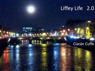
- 1. Liffey Life 2.0 Ciarán Cuffe
- 2. riverrun, past Eve and Adam's, from swerve of shore to bend of bay
- 4. Bay
- 5. Centre City
- 6. Park
- 7. River Liffey
- 17. Liffey Boulevard
- 19. Fionn Uisce O’Connell Diageo Land Connecting places Scooter Island The Gut Pigeon Sisters
- 20. Whose Dublin?
- 21. Fionn Uisce
- 25. View of Dublin from the Magazine Fort
- 26. View of Dublin from the Magazine Fort
- 28. Magazine Fort
- 30. Diageo Land
- 32. Heuston Square
- 33. Ten Footballs at Heuston Bridge
- 34. Heuston Station from Frank Sherwin Bridge
- 35. Amsterdam Station from Stationsplein Bridge
- 36. Heston Station with a touch of Amsterdam
- 37. Welcome to Dublin City?
- 38. Wolfe Tone Quay 24th October 2011
- 39. Wolfe Tone Quay 25th October 2011
- 40. Liffey Crack Traffic Calming, October 2011
- 41. Paint the Town Black? No, thanks. #ToArthur
- 44. Collins Barracks connected by new footbridge to Tate Dublin
- 45. Scooter Island
- 46. Scooter Island, The Dead House, James Joyce Bridge
- 47. Moira House, Usher’s Island 1752
- 48. HSE Offices, Usher’s Island 2012
- 49. 1973
- 50. Architectural Review 1973 “Without question it is the quays which give topographical coherence to Dublin. They are the frontispiece to the city and the nation: grand yet human in scale, varied yet orderly, they present a picture of a satisfactory city community: it is as though two ranks of people were lined up, mildly varying in their gifts, appearance and fortune, but happily agreed on basic values.” Wright, L. , & Browne, K assisted by Jones, P
- 51. Arran Quay 1973
- 52. Arran Quay 2012 Urban Renewal Tax incentives, the early years…
- 54. Urban Renewal Tax incentives, the early years…
- 55. Narrow Footpath
- 56. Road works, but little change on footpaths
- 58. Arran Quay plaza
- 59. Arran Plaza
- 60. Four Courts, Inns Quay, mind the gap
- 62. Filter Lane islands, not a pleasant place for pedestrians
- 63. Left-turn filter lanes of Dublin
- 68. Christchurch, alternative view two
- 69. Christchurch, Architectural Review 1973
- 70. O’Connell
- 71. Saved by Charlie Haughey
- 73. Developed by Mick Wallace
- 75. Locks on the Liffey
- 76. College Green, aerial view
- 77. College Green, alternative view
- 78. Roman town
- 79. O’Connell Street Grafton Street Dublin town Quays Liffey
- 80. O’Connell Bridge, aerial view
- 81. O’Connell Bridge, alternative view
- 84. Not a pub
- 85. Public Place Public place includes— • (a) any highway, • (b) any outdoor area to which at the material time members of the public have or are permitted to have access, whether as of right or as a trespasser or otherwise, and which is used for public recreational purposes. Criminal Justice (Public Order) Act, 1994 Public place means • any street, road or other place to which the public have access with vehicles whether as of right or by permission and whether subject to or free of charge Road Traffic Act, 1961
- 86. Confused? Me too
- 87. Happy St. Patrick’s Day
- 88. Aldo Rossi “The city is the locus of our collective memory… There is something in the nature of urban artifacts that renders them very similar – and not only metaphorically – to a work of art.”
- 89. The Gut
- 90. View looking upriver from Seán O’Casey Bridge
- 91. The Liffey Campshires – a success story
- 92. Fergal McCarthy on his Island 2011
- 93. Brian Vahey on his Island 1982
- 95. Land’s end. Sir John Rogerson’s Quay
- 96. The Gut
- 98. The Gut
- 99. The Bridge
- 100. The Gut
- 101. The Bridge
- 102. Pigeon Sisters
- 103. View from East-Link looking towards Dublin Bay
- 105. The Great South Wall
- 106. Pigeon House
- 107. Great South Wall Tea room Ice cream Bird watch Destination
- 111. Green Party Dublin City Centre Cycle Plan
- 112. Now what? • Tate Dublin • Bridge the Gut • Liffey Boulevard – link the Park to the Sea • Civilised Streets – widening footpaths
- 113. Whish! A gull. Gulls. Far calls. Coming, far! End here.
- 114. City Intersections, October 2012
Notes de l'éditeur
- It’s not that often that Dublin looks like Tokyo, and that’s probably why I love this shot I took of the Liffey Quays from O’Donovan Rossa Bridge at the bottom of Winetavern Street. The moon was rising in the East, and O’Connell Bridge House, one of Desmond Fitzgerald’s worst mistakes looks almost appealing by moonlight. I was standing close to where the áthcliath or ford of the hurdles was that gave our city – BaileÁthaCliathas Gaeilge. Colm Lincoln’s book “Dublin as a work of Art” is really a story about the author’s love for Dublin and specifically the Liffey Quays. He states:“The Liffey, with its long line of quays, has been central to the development of Dublin. It was to the quays that maritime trade came and the battle over its displacement – as bridge construction shoved port activity relentlessly further downstream – resulted in some of the city’s important characteristics: a sequence of cross-river axes and a long and distinctive river front punctuated by a display of great monumental architecture.”
- James Joyces’s Finnegan’s Wake flirts with the river from the opening lines to the finish. In a lovely opening line he commences:“riverrun, past Eve and Adam's, from swerve of shore to bend of bay.”Of course Eve and Adam’s is the church off Merchant’s Quay, so his book starts near to where Dublin began, close to where the Scandinavian settlers drew up their long-boats twelve hundred years ago.Half a million people live in Dublin, almost two million dwell in its functional urban region or “travel to work area”. I want to focus on the inner city, between the Phoenix Park and Dublin Bay. I believe that the Quays have been neglected and that radical action is needed to restore the Liffey Corridor to a state that we can be proud of that allows it to function as the front room of the city, and the nation.
- Dublin Bay is a crucial part of the image of the city. It’s not as accessible as it should be: the Port, the sewage plants, the power plants, the dumps all act as barriers. They conspire to block us from welcoming the sea into the city. When we talk about the city we need to talk about the old city and the inner city. Twenty five years ago the centre of Dublin was haemorrhaging its population and the inner city’s population was down to 65,000 people. The blunt instrument of tax incentives introduced in 1986 helped reverse this trend and thankfully the city centre population grew dramatically through the nineties and noughties.
- If the Bay is the bookend to the east the Park is the bookend to the west. Again, the relationship to the city is flawed. The city car pound was once located at the crucial meeting point of the Park and the city. Now it’s the Criminal Courts. That’s not the perfect civic building, but it is a new landmark that marks the transition from green leaves to brown brick.
- The River is the unifying link, and I suggest that a few improvements in linkages, places and spaces along or close to the river could improve the image of the city and our sense of civic pride.
- I also believe that we need a Liffey Boulevard on the Quays to make it easier and more pleasant to walk and cycle between the Park and the Bay.
- I’ll start at the Phoenix Park, the fionnuisce or clear waters of the royal deer park that celebrates a 350the anniversary in 2012. I’ll work downstream across Diageo Land, and The Gut before finishing close to the Hotel that Pigeon sisters ran for cross-channel ferry passengers in the early Nineteenth century.
- Dublin’s changed a lot in the last twenty years, and not just in terms of the built environment. Many of those who come to Ireland for work or education have settled close to the Liffey Quays. Polish, Nigerian and Chinese voices are common on Dublin streets.
- FionnUisceThe Phoenix Park is the People’s Park of Dublin. It is well used in every season. In recent years car parking seems to have encroached more on the park, despite attempts by the Office of Public Works to curtail through traffic.
- In Phoenix Park there is an effort made to accommodate cyclists as well as cars, but all too often it feels like the car has the upper hand.
- . I love this view of Dublin from the Magazine Fort, with domes and spires in the distance.
- The trees have grown since the Eighteenth century, but the city and the river can still be glimpsed through the trees.
- The Magazine Fort can be the start or the end of the Liffey Boulevard.
- It’s a neglected empty monument and could happily accommodate a bike shop, café, museum or other activities. It apparently even contained a bakery during the emergency. The complex deserves to be reused and more closely linked to the city. It could even have a pedestrian and cycle link across to Lutyens’ War Memorial Gardens in Islandbridge.
- Diageo LandBack in the early 1980’s when I started studying architecture in UCD we undertook a fantastic project across all five years of the course studying the Liffey Quays, and produced a book edited by Gerry Cahill that contained our proposals.
- One of the projects was for a new public Square at Heuston. In some sense that has come about, with the restoration of Dr. Steven’s Hospital as the HSE Headquarters and the Luas stop outside the rail Station. In Parisian terms it’s more Place de la Concorde than Place des Vosges because of the traffic, but it works.I look at this view from my bedroom, and will never grow tired of it. It is stunning in all weathers. The Liffey lies just below and it never ceases to amaze.
- One morning I looked down and saw ten footballs in the mud, just beside Seán Heuston Bridge that carries the Luas beside the station.
- . In the Netherlands about 40% of train passengers arrive by bicycle and a large multi-storey bike park is provided outside the main railway station.
- The brightest signs on the Quays tell us how many car parking spaces are available. Personally I’d prefer to know more about the weather or cultural events, or not have the sign there at all in an age of smart phones and in car navigation systems.
- Funny things happen on Wolfe Tone Quay. Here’s a shot I took in October 20111. The river is on the right, the Quays on the left. The Civil Defence depot is also on the left, and their entrance was blocked by the floods.
- The following day the Quays were magically silent as engineers inspected the damage.
- The crack in the quay wall restricted traffic by one lane for several months afterwards. There may have been some traffic delays and increase in Luas passengers, but I guess what it showed was that we can take a lane of car traffic off the Quays without the economic life of the City grinding to a halt, and that’s probably a good thing.
- Let’s get back to Diageo. Don’t get me started on Arthur’s Day. I’m fond of a drink myself, put painting the town black?
- Here’s a view looking across the Thames at the Tate Modern, a fantastic conversion of an old power generation station into a modern art gallery.
- Here’s a view looking across the Liffey at the Guinness steam plant. Well, you can guess the rest.
- Ideally I’d like to get visitors out of the Guinness Store House, into the Tate Modern, Dublin, and then allow them to walk gently downhill and across the new footbridge across the Liffey and the Croppy Acre past the Luas stop and into the Museum of Ireland at Collins Barracks. It’s the total tourism experience: St. James’s Gate, the Tate and Irish history in one afternoon, plus a Luas to take you back to your hotel.
- Scooter IslandScooter Island or Ushers’ Island has seen better days. Sure, it’s got a Calatrava Bridge, but where doesn’t at this stage? The river frontage could do with more than a facelift.
- Here’s Moira House that was the Dublin home of the Earls of Moira. Had it survived the twentieth century it would have celebrated its 260th anniversary this year but it was demolished in the 1950s.
- The gate piers remain. We can do better than this.
- St. Pauls on Arran Quay graced the cover of the UK Architectural Review in 1973. The Cover said “Thainig an A.R. go dtíBaileAtháCliath
- .” Inside Brown and Wright argued: “Without question it is the quays which give topographical coherence to Dublin. They are the frontispiece to the city and the nation: grand yet human in scale, varied yet orderly, they present a picture of a satisfactory city community: it is as though two ranks of people were lined up, mildly varying in their gifts, appearance and fortune, but happily agreed on basic values.”
- Thankfully the road plans drawn up by the London consultants didn’t get the green light, but most of the Georgian buildings were lost and replaced by Zoe pastiche.
- Thankfully the road plans drawn up by the London consultants didn’t get the green light, but most of the Georgian buildings were lost and replaced by Zoe pastiche.
- Thankfully the road plans drawn up by the London consultants didn’t get the green light, but most of the Georgian buildings were lost and replaced by Zoe pastiche.
- This is the “Chuaigh an A.R. as BaileAtháCliath” shot. If you look across the river from St. Pauls you see this petrol station, a monument to the first phase of urban renewal tax incentives from the 1980s. For a time it even graced the cover of a Dublin Corporation brochure urging you to invest in Dublin. It would be fair to say it hasn’t aged well.
- The footpaths along the quays are often microscopic in width. However a wider footpath and bike path would still allow for a car lane and a bus lane to be placed on Arran Quay. It is time to reallocate road space.
- Ironically the City Council seems to have the budget to completely repave vast swathes of footpath at the moment, but appears not to be widening footpaths.
- There’s a pleasant widening of the Quays at the junction of Arran Quay and Church Street. Road engineers have grabbed the space to fit in more traffic, but perhaps a small plaza could be provided.
- The buildings alongside could open out onto this and would attract new uses like galleries and eateries.Apologies for the graphics, but I suspect you get the gist of it
- . Further along the Quays the magnificent setting of the Four Courts deserves a wider footpath on the river side of the Quays, as well as besides the building itself.
- There’s a problem in how we manage and plan public space. Architects often restrict themselves to individual buildings. Planners fret about the relationship of buildings to each other. However the most important job of all – planning the space between buildings – is left to road engineers who often simply don’t have the training to mediate between the different functions that this space must perform. They all-to-often strive to maximise the traffic carrying function of the space, not realising that the economic and social functions of public space are equally important.
- Now that I’m on a roll about civil engineering I need to mention left-turn filter lanes. I’ve counted about eighty of them between the canals and they all need to be removed. They destroy the public space of the city, converting meeting places to highways.
- They all have to go, let’s start with the ones along the Quays and slowly but surely reclaim the street.
- It can take you three pedestrian light phases to cross the junction at Christchurch. That is wrong. I want to narrow the road so that it becomes a civic meeting space rather than a traffic junction. Even on New Year’s Eve the Gardaí hustle you off the road once the bells have struck twelve.
- . I want to narrow the carriageways so that tourist and Dubliners can feel that the city is their own. People are more important than cars.
- Here’s another variation on how the Christchurch junction might work
- Here’s how the Architectural Review say Christchurch back in 1973. I wouldn’t copy that, but I think we need to reduce the traffic carrying-capacity of these junctions so that people’s voices can be heard.
- O’ConnellI was never a fan of Charlie Haughey, but I do credit him with saving Temple Bar. I sat in a crowded CIE Hall back during some 1980s election campaign when Charlie had the wit and conviction to say that Temple Bar would be saved. That didn’t stop the rise of the super-pub, but at least many of the buildings and streets were saved and many of the cultural uses that grew up there are housed in well-designed new premises.
- Another rogue, Mick Wallace was responsible for the Quartier Bloom off Ormond Quay, a charming part of Dublin where Italian is the second language.
- I like the locks on the Ha’penny Bridge. I’ve no doubt that some official will remove them, but they’re a bit of fun that adds to the interest of passing over the Liffey.
- College Green is oozing with potential, has some spectacular buildings, but is currently a traffic nightmare. The first thing I’d like to do though is take a chainsaw to the ungainly trees that are blocking the views of the Old Bank of Lords (now the Bank of Ireland) and the front of Trinity College.
- The next step is to replicate what has been done in many London Square in recent years. Restrict the car traffic and liberate the pedestrian. Then we can all breathe again.
- Often Roman towns had two main roads at right angles to each other; the Decumanus and the Cardo.
- If the route from Parnell Square down O’Connell Street and through College Green and Grafton Street to Steven’s Green is our Decumanus than the Quays must surely be our Cardo.
- O’Connell Street Bridge currently seems to have at least eight, or possibly nine lanes of traffic running across it. It deserves to be a civic space.
- Let’s tame the traffic, perhaps down to four lanes and give space to the pedestrian in this important civic space.
- Given that the city doesn’t cherish O’Connell Street Bridge it is no surprise that O’Connell Bridge House sports a large alcohol ad. Once as I walked down the boardwalk and English weekend tourist stopped his mates to shout. “It’s a pub and it’s ten floors high”. Whatever about our English visitors we clearly have an alcohol problem, an image problem and a public space problem.
- I’m interested in our definitions of public space and place. In Irish law I can only find references to public spaces in the road traffic acts, and public spaces in the criminal justice legislation. Curiously in the road traffic acts a public space is somewhere that you can have access to with your car. That speaks volumes about our relationship to the city.
- The junction beside Liberty Hall is particularly poorly designed. The combination of cattle barrier-style pedestrian enclosures and indecipherable road signs requires some long hard soul-searching by the city fathers and mothers. It could be better.
- I took a photo of Bachelors’ Walk on the North Quays on St. Patrick Day, fully pedestrianised for, maybe an hour and a half. Why not do this once a month on a Sunday afternoon so that we can look again at our city rather than rush through it.
- Works of art deserve to be treated with respect.
- The GutThe Gut refers to the stretch of water where the Grand Canal and the River Dodder enter the sea.
- The development in Dublin’s Docklands over the last twenty years has led to significant civic improvements
- The walkways and cycle lanes along the campshires as the Quays are referred to East of Matt Talbot Bridge are a magical change in how we view and use the waterside. Last summer I there were kayaks for rent and my ten year-old son and I had a wonderful adventure paddling between the Beckett Bridge and the Jeanie Johnston Tall Ship. We saw the city from a whole new angle..
- Fergal McCarthy’s temporary island installation was great addition to this stretch of the River. It made people laugh, smile and rethink their perception of the space between the Quay walls. I want more of these.
- Back in 1982 my brother-in-law Brian Vahey a stage designer also placed a temporary island in the River Liffey. His was a wooden pyramid with mementoes of the old Theatre Royal inside. He moored it near Burgh Quay close to Hawkins House which replaced the Theatre.
- That was one of my first introductions to the River as I acted as caretaker for his island, waiting for the drunken shouts once the pubs had closed.
- Sir John Rogerson’s Quays grinds to a sudden halt on the South Quays just before the Gut.
- . I would like to see a simple structure for pedestrian and cyclists that would link the city to the bay.
- Once this happens, the new walkway and cycleway that I’m proposing on Liffey corridor would inevitably find its way down to the Pigeon House chimneys, close to where the Pigeon Sisters ran their hotel back in the 1800s.
- A final stop might be the remnants of an old fortification, close to where the infill of the bay has created a new beach. Reflecting the Magazine Fort the wall could be adapted to house a coffee shop, bike rental, visitor centre or other activities. Pedestrians could continue down the Great South Wall to where the city meets the Bay.
- A few years ago I published an earlier version of this proposal as part of a Green Party cycle plan for Dublin. Many of the ideas were included in that proposal.
- Now what? Well, it’s a good time to be talking about the Liffey Corridor. The Dublin Bikes scheme is set to expand towards the end of 2012, and that means that something must be done with the Liffey Quays to make them more pedestrian and cycle friendly. Perhaps the Tate Dublin and bridging the Gut will never happen, but it’s part of debate that’s worth having. There’s an argument to be had as to whether a cycle lane should be beside the quay wall, or closer to the building edge. Should there be one wide cycle lane on one quay or a lane on both quays? Should the traffic flow on the Quays be reversed again, or made two -way? Multi-lane one-way streets are bad for the life of the city. Would a lower 30kph speed limit obviate the need for a separate cycle lane in the first instance? Perhaps.
- Certainly wider footpaths would make our Quays more liveable, and a more enjoyable place. In the meantime I’m hoping that the ideas in this presentation will contribute to the debate.
- Thank You