1. Mitigation 4.6 Neighborhoods
Measures to mitigate e ects to community, govern- is section describes the neighborhoods adjacent
ment, and military facilities are summarized in to the project alignment and the anticipated
Table 4-6. e ects on these neighborhoods from the long-term
operation of the Project. E ects on neighborhoods
Community Facilities include adverse and bene cial e ects on neighbor-
Mitigation e orts will involve coordination hood character, quality of life, and cohesion. For
with individual property owners as necessary additional information and references, see the
to appropriately address e ects to community Honolulu High-Capacity Transit Corridor Project
facilities. E ects on access, signage, or parking will Neighborhoods and Communities Technical Report
be replaced or compensation will be provided. In (RTD 2008d).
addition, all property will be acquired following
the Federal Uniform Relocation Assistance and Real 4.6.1 Background and Methodology
Property Acquisition Policies Act and applicable Neighborhood board boundaries were used to
State regulations. de ne neighborhood divisions. Neighborhood
boards were created by City Charter to facilitate
e City will coordinate and consult with other citizen participation on the island and in regional
agencies and stakeholders on the nal design of the planning activities. Only those neighborhoods
streetscape a ected by the Project. adjacent to the project alignment are discussed in
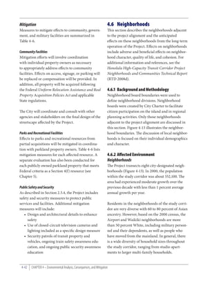
this section. Figure 4-13 illustrates the neighbor-
Parks and Recreational Facilities hood boundaries. e discussion of local neighbor-
E ects to parks and recreational resources from hoods is focused on their individual demographics
partial acquisitions will be mitigated in coordina- and character.
tion with parkland property owners. Table 4-6 lists
mitigation measures for each a ected resource. A 4.6.2 Affected Environment
separate evaluation has also been conducted for Neighborhoods
each publicly owned parkland property that meets e Project transects eight city-designated neigh-
Federal criteria as a Section 4(f) resource (see borhoods (Figure 4-13). In 2000, the population
Chapter 5). within the study corridor was about 552,100. e
area had experienced moderate growth over the
Public Safety and Security previous decade with less than 1 percent average
As described in Section 2.5.4, the Project includes annual growth per year.
safety and security measures to protect public
services and facilities. Additional mitigation Residents in the neighborhoods of the study corri-
measures will include: dor are very diverse with 60 to 80 percent of Asian
• Design and architectural details to enhance ancestry. However, based on the 2000 census, the
safety Airport and Waikīkī neighborhoods are more
• Use of closed-circuit television cameras and than 50 percent White, including military person-
lighting included as a speci c design measure nel and their dependents, as well as people who
• Security patrols of transit property and have moved from the mainland. In general, there
vehicles, ongoing train safety awareness edu- is a wide diversity of household sizes throughout
cation, and ongoing public security awareness the study corridor, ranging from studio apart-
education ments to larger multi-family households.
4-42 CHAPTER 4 – Environmental Analysis, Consequences, and Mitigation
2. June 2010
Figure 4-13 Corridor Neighborhoods
!"$
PEARL CITY
WAIPAHU
!"# `AIEA !"%
!"#
"
`EWA !"#
KALIHI-PALAMA
HONOLULU
INTERNATIONAL
AIRPORT
DOWNTOWN
LEGEND KAKA`AKO
Neighborhoods ALA MOANA
The Project
Study Corridor Boundary
Fixed Guideway Station
Honolulu High-Capacity Transit Corridor Project Environmental Impact Statement
Maintenance and Storage Facility Option
Park-and-Ride Access Ramp
0 1 2
4-43
Miles
3. Due to their location in the urban core, the development for a uent and independent farmers.
Kalihi-Palama, Downtown, Ala Moana-Kaka‘ako, Retail and commercial venues include the Pearl
Waikīkī, and McCully-Mō‘ili‘ili neighborhoods City Shopping Center and the Pearl Highlands
are distinct from the ‘Ewa O‘ahu neighborhoods, Center. Neal S. Blaisdell Park at the edge of Pearl
which are predominantly comprised of single- Harbor (East Loch) is a regional recreational
family residences. Households in these urban core amenity that is popular for outdoor community
neighborhoods tend to be smaller with more than activities. A small area known as the Banana Patch
40 percent of individuals living alone. lies within the Pearl City neighborhood boundary.
is neighborhood is unique in that, while it is in
e following paragraphs describe the general an urban region, residents are able to maintain an
land use, character, and unique physical or social agricultural, subsistence lifestyle. e community,
attributes of the study corridor neighborhoods. which is discussed in more detail in Section 4.7, has
a high concentration of Filipinos.
`Ewa
‘Ewa is one of O‘ahu’s suburban growth centers and `Aiea
is experiencing rapid change. It encompasses the is community consists of residential develop-
communities of Kapolei (the “second city”), ‘Ewa ment, mixed-commercial uses, and military
Villages, ‘Ewa by Gentry, Honouliuli, ‘Ewa Beach, housing and facilities. Most of the residential
Ocean Pointe, and Iroquois Point. Between 1990 subdivisions are mauka of Kamehameha Highway.
and 2000, the population of this neighborhood e makai areas tend to be commercial, light
doubled as sugar cane lands were developed into industrial, and military. Pearlridge Center is a
housing and commercial uses. Despite ongoing major employment center and tourist destination.
development, some former sugar cane land is being Many ‘Aiea residents work at nearby Pearl Harbor
used for diversi ed agriculture. Naval Base, Hickam Air Force Base, and Marine
Corps Base Camp Smith.
Waipahu
Historically, the Waipahu community makai of Airport
Interstate Route H-1 (H-1 Freeway) was a sugar e Airport neighborhood is characterized by
plantation town, and the community retains strong non-residential land uses. e Airport Com-
identity to this historic economic activity. Newer mercial District, located makai of the Nimitz
apartment buildings and strip retail plazas are Viaduct, is primarily an industrial, commercial,
generally limited to the fringes of the commercial service-oriented district. e Māpunapuna Light
district along Farrington Highway. Waipahu has Industrial District, between the Moanalua Freeway,
a recreational center, health clinics, churches, and Moanalua Stream, Nimitz Highway, and Pu‘uloa
social services o ces. Many residents travel outside Road, includes primarily light industrial businesses
of the community for employment. with some retail and commercial businesses and
o ces. e Fort Sha er Military Reservation,
Pearl City mauka of the H-1 Freeway in Moanalua, is an
e Pearl City area consists of residential devel- active military base. e Pearl Harbor Naval Base
opment, mixed-commercial uses, and military residential housing area (known as Catlin Park
housing and facilities. e community was origi- Housing) is bounded by Salt Lake Boulevard,
nally developed by Benjamin Dillingham in the Pu‘uloa Road, Nimitz Highway, and Namur Road/
1890s as Hawai‘i’s rst planned city and suburban Valkenburgh Street.
4-44 CHAPTER 4 – Environmental Analysis, Consequences, and Mitigation
4. Kalihi-Palama warehouses and light industrial uses with new
e Kalihi-Palama neighborhood contains a wide urban mixed-use development. e area between
variety of land uses with unique community Ke‘eaumoku and Pensacola Streets mauka of
identities, such as Kalihi Kai, Kapālama, and Kapi‘olani Boulevard is characterized by two- and
Iwilei. e Kalihi-Palama communities makai three-story walk-up apartments in a quieter
of the H-1 Freeway are a mix of residential, busi- residential environment. e neighborhood’s shop-
ness, retail, and industrial-commercial land uses. ping and retail centers, especially the Ala Moana
Residential housing is generally more prevalent in and Ward Centers, are popular with residents as
the mauka areas, and commercial and industrial well as tourists staying in nearby Waikīkī. ese
businesses are more prevalent in the makai areas. centers are being expanded and redeveloped. Other
Businesses vary in size from “mom-and-pop” activity centers include a number of popular parks,
stores to big box retail establishments, such as the Neal S. Blaisdell Center and Concert Hall, and
Costco and Best Buy, as well as Dole Cannery Mall. the Hawai‘i Convention Center.
e Bishop Museum (mauka of the H-1 Freeway)
is a popular tourist attraction that houses an Demographic Characteristics
extensive collection of Hawaiian artifacts and royal Table 4-7 presents economic and racial character-
family heirlooms. istics for each neighborhood based on the 2000
census data. It illustrates considerable variation in
Downtown neighborhood population size and median house-
Downtown Honolulu is a vibrant city center and hold income. Racial characteristics vary less widely.
one of the State’s largest employment centers. Military housing areas in the Airport neighbor-
It is experiencing substantial redevelopment to hood have higher percentages of White and Black
higher-density land uses. It is the State’s principal residents in comparison to the racial composition
government o ce and business center, as well of O‘ahu.
as the location of many tourist attractions. It
continues to have a substantial residential popu- 4.6.3 Environmental Consequences
lation. e Hawai‘i Capital District is the seat and Mitigation
of City and County, State, and Federal govern- Environmental Consequences
ment o ces and includes a number of historic is section evaluates potential e ects on neigh-
mid-19th century buildings. e historic China- borhoods adjacent to the project alignment. A
town District is a popular attraction for O‘ahu discussion of neighborhood safety and security
residents and tourists. High-rise condominiums issues is found in Section 4.5. Aesthetic issues and
and apartments are interspersed throughout their e ect on adjacent land uses are discussed in
Downtown. Fort Street Mall is a major gathering Section 4.8.
place for Hawai‘i Paci c University students,
downtown workers, and residents. No Build Alternative
Under the No Build Alternative, the Project would
Ala Moana-Kaka`ako not be built and would not have any impacts to
e Kaka‘ako community encompasses the neighborhoods. e quality of life, however, would
614-acre Kaka‘ako Community Development be reduced by increased congestion, increased
District from the shoreline makai of South King travel time, and reduced mobility a ecting single-
Street and between Pi‘ikoi and Punchbowl Streets. occupancy vehicles, high-occupancy vehicles, and
Redevelopment is replacing old one- and two-story bus transit passengers.
June 2010 Honolulu High-Capacity Transit Corridor Project Environmental Impact Statement 4-45
5. Table 4-7 Year 2000 Demographic Characteristics of Neighborhoods
American Native
Household Indian & Hawaiian Two or
Median Alaska & Pacific More
Neighborhood Income White Black Native Asian Islander Other Races
`Ewa $58,230 17% 2% 0.2% 50% 7% 1% 23%
Waipahu $60,270 9% 2% 0.2% 62% 9% 1% 18%
Pearl City $66,500 16% 2% 0.2% 56% 6% 1% 18%
`Aiea $55,240 18% 2% 0.3% 49% 9% 1% 21%
Airport $41,000 61% 12% 1.0% 11% 1% 4% 9%
Kalihi-Palama $31,630 4% 1% 0.1% 66% 14% 1% 14%
Downtown $29,950 22% 1% 0.2% 58% 6% 1% 12%
Ala Moana-Kaka`ako $30,620 19% 1% 0.2% 62% 4% 1% 12%
Total O`ahu $52,280 21% 2% 0.2% 46% 9% 1% 20%
Source: Department of Planning and Permitting, City and County of Honolulu, 2006. Selected Economic Characteristics: 2000 by Neighborhood
Area.
Project Plan (SSMP) for new xed guideway projects
e Project will provide people living and working (49 CFR 633). e SSMP addresses the technical
in the neighborhoods within the study corridor and management strategies for analyzing safety or
with increased mobility. e Project will provide determining security risks throughout the life of
an alternative to traveling by personal vehicle or the Project. e SSMP commits that the highest
bus transit within the existing transportation practical level of operational safety and security
corridors. Passengers using the new transit system will be used. In addition, it lays the foundation
will experience reduced travel time to other for future safety and security once the Project is
neighborhoods and growth centers along the operating. e Honolulu Police Department, the
project alignment and near transit stations. e Honolulu Fire Department, the Department of
Project will provide a reliable and e cient travel Emergency Management, the Honolulu Emergency
mode for accessing the region’s current and future Services Department, and other State and Federal
jobs, shopping, and social resources, particularly agencies, as appropriate, will be involved in
those in Kapolei and Downtown—the major urban preparing and implementing the SSMP. e SSMP
centers of the study corridor in the future. is is reviewed and updated regularly throughout the
increase in mobility for neighborhood residents life of the Project.
will generally improve the quality of life, especially
for those with limited nancial resources and those Potential new development and redevelopment
who may be transit-dependent. along the project alignment, as well as the scale of
the transit system itself, may a ect the character
e transit agency could experience three types of of development along the alignment. is change
crimes—crimes against persons, crimes involving in character will not have a substantial e ect on
transit property, and other crimes committed on the existing development patterns or community
transit property. To reduce the potential for crime, character within the surrounding neighborhoods.
the FTA requires the development and imple- Currently, most of the residential housing is more
mentation of a Safety and Security Management prevalent within the mauka areas, and commercial
4-46 CHAPTER 4 – Environmental Analysis, Consequences, and Mitigation
6. and industrial businesses are primarily within conducting their normal travel patterns within
the makai areas. e Project will not substantially the community. Potential redevelopment along
change this development pattern. Since the transit the project alignment, and in particular at the
system will be elevated, it will not create a physi- station locations, may represent an asset to the
cal barrier to pedestrian or other forms of travel neighborhood by providing new resources and an
within the study corridor. It also will not pose a accessible transit option.
barrier to the social network of the community
since it will be located within an existing transpor- Pearl City
tation corridor or in the ‘Ewa area, along a planned e project alignment extends through the
future transportation system. Pearl City neighborhood, along the median of
Kamehameha Highway, a heavily traveled roadway
e following paragraphs describe the Project’s with adjacent multi-story commercial uses near
e ects on individual neighborhoods. the Pearl Highlands Station. e surrounding
residential uses will not be a ected by property
`Ewa acquisitions and, being located within the highway
e three transit stations in ‘Ewa—East Kapolei, median, the Project will not form a barrier to
UH West O‘ahu, and Ho‘opili—as well as the adjacent residential communities as residences are
project alignment will not a ect community oriented away from the highway. In addition, being
character and cohesion in ‘Ewa because the an elevated structure, the transit system will not
a ected area is undeveloped and primarily used for create a physical barrier to pedestrians or other
agriculture (see Section 4.2 for more information forms of travel within the community. e Project
on farmlands). e area is planned to be developed will not a ect community identity or cohesion
into urban land uses, and the Project will support as the transit system will be compatible with the
these development plans. existing community character along the alignment.
e Project will impact the Banana Patch commu-
Waipahu nity, which is discussed in Section 4.7.
e project alignment follows Farrington Highway
through the Waipahu neighborhood. e area is `Aiea
urbanized, with land uses along the highway con- e route through the ‘Aiea neighborhood con-
sisting primarily of commercial uses, strip retail tinues to follow Kamehameha Highway, and the
plazas, and both mid-rise and medium-density e ects will be very similar to those described for
apartments. e Koko Head end of Farrington the Pearl City and Waipahu neighborhoods. Most
Highway in Waipahu consists mostly of single- of the residential areas are mauka of Kamehameha
family housing but also includes Waipahu High Highway with land uses makai of the highway
School. Most of the residential communities are being primarily commercial or military. As such,
oriented away from this heavily traveled roadway. the Pearlridge Station will not create a barrier to
Because Farrington Highway functions as both adjacent communities nor will it limit pedestrian
a major arterial and collector road, and varies in or other travel modes within these communities.
width from four to six lanes with a landscaped As the transit route passes Aloha Stadium, there
median, the transit facility will not create an are very few buildings adjacent to the alignment
access or transportation barrier between the due to the expanse of the stadium parking. Few
makai and mauka sides of the road. As an elevated residential communities are located nearby.
structure, which will span all intersections, it
will not prevent pedestrians and motorists from
June 2010 Honolulu High-Capacity Transit Corridor Project Environmental Impact Statement 4-47
7. Airport these two districts between the Downtown uses
e Project will travel along busy, heavily traveled and Honolulu Harbor; therefore, the transit system
Kamehameha Highway and enter the Airport will have little e ect on their uses. However, it will
on Aolele Street. e neighborhood is primarily contrast with their historic character. As the align-
characterized by military and industrial uses ment transitions to Halekauwila Street, a relatively
and Honolulu International Airport. Most of the narrow city street, the adjacent buildings become
residential land uses are mauka of the Nimitz Via- primarily mid-rise government o ce buildings
duct. e Project will require acquisition of some with little or no open space between them. Views
businesses on Ualena Street and Waiwai Loop and of the alignment will be limited to short segments
no changes in current land uses. e guideway is as the guideway crosses city streets since high-rise
not expected to be a visual or physical barrier in buildings and tall trees already obstruct views. e
the neighborhood and will not a ect community transit system will be elevated so it will not a ect
identity or cohesion. the ow of tra c, bicyclists, or pedestrians within
the Downtown neighborhood.
Kalihi-Palama
e Project through the Kalihi-Palama neighbor- Ala Moana and Kaka`ako
hood follows Dillingham Boulevard. e boulevard e Project will extend to Ala Moana Center trav-
is a major arterial that travels through smaller, eling mostly along Halekauwila and Kona Streets.
well-established residential communities, but also e transition between these streets will require
functions as a major collector for neighborhood property acquisitions and displacements. Land
circulation. Small-scale commercial businesses and uses adjacent to the alignment include two- and
a few historic land uses line the boulevard. Dilling- three-story walk-up apartments and commercial
ham Boulevard is a much narrower roadway than uses within the Kaka‘ako area and newer urban
either the Farrington or Kamehameha Highways. mixed-use development within the Ala Moana
As a result, the Project will require widening the area. In general, land uses are less dense than
roadway to maintain the same number of travel in the Downtown neighborhood. Kaka‘ako has
lanes while accommodating the guideway’s sup- been designated a redevelopment area, which may
port columns. Several true kamani trees will also result in a change in character along the Project
be removed by the Project. Impacts will occur to alignment. However, substantial development has
historic properties, as discussed in Section 4.16. recently occurred in the neighborhood; several
high-rise condominium developments have been
Downtown built, and additional residential and commercial
e Project will continue through the Downtown developments are planned. e elevated transit
neighborhood within the median of Nimitz structure will not create a barrier to pedestrian or
Highway. is highway is similar to Farrington other modes of travel.
and Kamehameha Highways as it is a heavily trav-
eled roadway with limited cross tra c. As such, Mitigation
the highway already represents a physical barrier Since there will be no adverse e ects to these
to the neighborhoods on each side. e Project neighborhoods, no mitigation is required. Ongo-
will not create a new barrier or a ect the physical ing coordination e orts with the public will help
character of adjacent communities. Within the develop design measures that will enhance the
Downtown area, the Project will pass the historic interface between the transit system and the sur-
districts of Chinatown and Merchant Street. rounding community.
Nimitz Highway is located along the perimeter of
4-48 CHAPTER 4 – Environmental Analysis, Consequences, and Mitigation
8. 4.7 Environmental Justice (1) is predominately borne by a minority
Executive Order 12898, Federal Actions to Address population and/or a low-income popula-
Environmental Justice in Minority Populations and tion; or
Low-Income Populations (USEO 1994) was signed (2) will be su ered by the minority popula-
by President Clinton on February 11, 1994. is tion and/or low-income population and
Executive Order directs Federal agencies to take is appreciably more severe or greater in
appropriate and necessary steps to identify and magnitude than the adverse e ect that will
address disproportionately high and adverse e ects be su ered by the non-minority popula-
of their projects on the health or environment of tion and/or non-low-income population.
minority and low-income populations to the great- (USDOT Order 5610.2).
est extent practicable and permitted by law. e
order directs Federal actions, including transporta- e EJ analysis for the Project identi es O‘ahu
tion projects, to use existing law to avoid discrimi- Metropolitan Planning Organization (O‘ahuMPO)
nation on the basis of race, color, or national origin EJ Areas within the study corridor and presents the
and to avoid disproportionately high and adverse impact determinations regarding the likelihood
impacts on minority and low-income populations. that disproportionately high and adverse impacts
ese are o en referred to as environmental justice will be experienced in those areas. is section
(EJ) populations. discusses potential measures to avoid, minimize,
and/or mitigate those impacts to EJ populations
ere are three fundamental EJ principles: and documents the Project’s public outreach e orts
• To avoid, minimize, or mitigate dispropor- to EJ communities. For more detailed information
tionately high and adverse human health or and references, see the Honolulu High-Capacity
environmental e ects, including social and Transit Corridor Project Neighborhoods and Com-
economic e ects, on minority populations munities Technical Report (RTD 2008d).
and low-income populations
• To ensure the full and fair participation by 4.7.1 Background and Methodology
all potentially a ected communities in the Regulatory Context
transportation decision-making process e principles of EJ are rooted in Title VI of the
• To prevent the denial of, reduction in, or Civil Rights Act of 1964, which prohibits discrimi-
signi cant delay in the receipt of bene ts nation on the basis of race, color, and national
by minority populations and low-income origin in programs and activities receiving Federal
populations nancial assistance. Additional laws, statutes,
guidelines, and regulations that relate to EJ issues
Executive Order 12898 requires all Federal include the following:
agencies to incorporate EJ into their missions by • Title 49 of the United States Code Sec-
identifying and addressing disproportionately tion 5332 (49 USC 5332), Mass Transportation
high and adverse human health or environmental (USC 1994)
e ects of their programs and policies on minorities • Title 49 of the Code of Federal Regulations
and low-income populations and communities. Part 21 (49 CFR 21), Nondiscrimination in
A “disproportionately high and adverse e ect” is Federally Assisted Programs of the Depart-
de ned as follows: ment of Transportation—E ectuation of Title
Disproportionately High and Adverse E ect on VI of the Civil Rights Act of 1964 (CFR 1996d)
Minority and Low-Income Populations means • Executive Order 12898, Federal Actions to
an adverse e ect that: Address Environmental Justice in Minority
June 2010 Honolulu High-Capacity Transit Corridor Project Environmental Impact Statement 4-49
9. Populations and Low-Income Populations (Asian), American Indian or Alaska Native, or
(USEO 1994) Native Hawaiian or Other Paci c Islander. Based
• Environmental Justice Guidance Under on guidance from the Federal Council on Envi-
the National Environmental Policy Act ronmental Quality (CEQ), “minority populations
(CEQ 1997b) should be identi ed where either: (a) the minority
• USDOT Order to Address Environmental population of the a ected area exceeds 50 percent
Justice in Minority Populations and Low- or (b) the minority population percentage of the
Income Populations (USDOT 1997) a ected area is meaningfully greater than the
• FHWA Actions to Address Environmental minority population percentage in the general
Justice in Minority Populations and Low- population or other appropriate unit of geographic
income Populations (FHWA 1998) analysis” (CEQ 1997b).
• Hawai‘i Revised Statutes (HRS) Chapter 368,
Hawai‘i Civil Rights Commission (HRS 1989) e term “low-income,” in accordance with
• Executive Order 13166, Improving Access USDOT Order 5610.2 and agency guidance, is
to Services for Persons with Limited English de ned as a person with a household income at or
Pro ciency (USEO 2000) below the U.S. Department of Health and Human
• Americans with Disabilities Act of 1990 Services (USHHS) poverty guidelines. ese
(ADA 1990) poverty guidelines are a simpli ed version of the
• Hawai‘i Environmental Justice Initiative Federal poverty thresholds used for administrative
Report (HEC 2008) purposes (e.g., for determining nancial eligibility
for certain Federal programs). e U.S. Census
Methodology Bureau has developed poverty thresholds, which
is analysis identi es potential e ects on minor- are used for calculating all o cial poverty popula-
ity and low-income populations that reside within tion statistics. e Census Bureau applies these
the study corridor. e e ects of the Project on thresholds to a family’s income to determine its
identi ed O‘ahuMPO EJ Areas were analyzed as poverty status.
follows:
• How well the Project will serve the transpor- O‘ahu, however, has unique demographic charac-
tation needs of the identi ed EJ populations teristics because minorities make up the majority
and communities of concern in comparison of the population. Because of this racial and ethnic
to all other population groups within the diversity, the O‘ahuMPO developed a method to
study corridor de ne O‘ahuMPO EJ Areas that are more meaning-
• Whether the e ects of the Project (e.g., ful to the demographics of the island. O‘ahuMPO
construction, visual, noise) will have dispro- EJ Areas are de ned as areas where the minority or
portionately high and adverse e ects on the low-income population concentration is meaning-
social, cultural, health, and well-being of the fully greater than the surrounding population.
identi ed EJ populations and communities
of concern as compared to other population Using 2000 Census data, O‘ahuMPO’s analysis
groups within the study corridor uses the Federal de nition of minority as well as
the “poverty thresholds” as de ned by the Census
De ning Environmental Justice Areas Bureau. Rather than relying on EJ de nitions that
USDOT Order 5610.2 and subsequent agency guid- are less meaningful to O‘ahu’s unique demographic
ance de nes the term “minority” to include any composition, O‘ahuMPO’s method normalizes
individual who is Black, Hispanic, Asian-American census block group data so that basic statistical
4-50 CHAPTER 4 – Environmental Analysis, Consequences, and Mitigation
10. measures can be applied. e method relates the activities were used to assist in identi cation of
relative concentration of a minority group or communities of concern.
low-income households within a census block
group to the total population within the census 4.7.2 Affected Environment
block group. A block group quali es as EJ if the Figure 4-14 shows the areas that have met the
relative frequency of one or more minority groups O‘ahuMPO EJ threshold that are within one-half
or low-income households was in the highest mile of the project alignment. Figure 4-15 shows
16 percent (greater than one standard deviation) areas identi ed as containing communities of
of frequencies across the island. Block groups concern. As described in Section 4.6, the physical,
were then assembled into the O‘ahuMPO EJ Areas social, and economic characteristics across and
(O‘ahuMPO 2004) (Figure 4-14). ese data are within each neighborhood vary, including the
presented in Section 4.7.2. racial, ethnic, and economic composition of the
population. e demographics of the neighbor-
Coordination with the City and County of Hono- hood areas are also described in Section 4.6.
lulu Department of Transportation Services (DTS),
DPP, HDOT, FTA, and the U.S. Environmental Table 4-8 lists each of the O‘ahuMPO EJ Areas
Protection Agency (EPA) resulted in the determi- illustrated in Figure 4-14, with the demographic
nation that the O‘ahuMPO method for determin- data from the 2000 census. It shows there is
ing O‘ahuMPO EJ Areas was appropriate for the considerable ethnic and racial diversity along the
Project. erefore, EJ populations for this Project project alignment.
consist of low-income and/or minority populations
that are within the O‘ahuMPO EJ Areas. Banana Patch Community
rough public involvement activities, a previously
Communities of Concern unidenti ed minority EJ area was identi ed. e
In addition to minority and income status, other Banana Patch community is not an O‘ahuMPO
data were used as additional indicators of commu- EJ Area. e Banana Patch, or lower Waiawa,
nities of concern, including linguistically isolated is located along the border of the Pearl City
households, transit-dependent populations, and and Waipahu neighborhoods. It is bounded by
areas with public housing and community services. Kamehameha Highway mauka, Farrington High-
e U.S. Census Bureau de nes a linguistically way makai, and the H-1 Freeway ‘Ewa. Neither
isolated household as a household in which all the Pearl City nor the Waipahu neighborhoods
members age 14 or over speak English less than were identi ed as EJ Areas using the O‘ahuMPO
“very well.” Block groups with 25 percent or more method. However, the Banana Patch area was
of households with no vehicle or with 21 percent identi ed as a minority EJ area a er outreach
or more linguistically isolated households are in July 2008 revealed that all residents who will
included in the areas designated as communities of be relocated as a result of the Project belong to a
concern and are illustrated on Figure 4-15. ese minority group. No other previously identi ed EJ
criteria serve to further identify potentially transit- Areas were identi ed.
dependent populations but are not included in the
de nition of EJ populations. Data on communities e Banana Patch community is located in Census
of concern also serve to direct public outreach Tract 80.01 Block Group 2, Block 2001, and Census
e orts. In addition to the census data, eld sur- Tract 87.01 Block Group 2, Block 2001. Some of the
veys, data gathered for other projects within the land in Census Tract 87.01 is used for construction
study corridor, and on-going public involvement equipment storage. ere are no residences in this
June 2010 Honolulu High-Capacity Transit Corridor Project Environmental Impact Statement 4-51
11. 4-52
!"$
PEARL CITY
WAIPAHU
14 !"# !"%
17 `AIE A
!"#
15
16
13
MAKAKILO
CHAPTER 4 – Environmental Analysis, Consequences, and Mitigation
ĀLIAMANU
Figure 4-14 Environmental Justice Populations within the Study Corridor
SALTLAKE 8
12
" 10
`EWA !"# 9
KAPOLEI 11 KALIHI-PALAMA
7
6
HONOLULU 4
INTERNATIONAL 2
LEGEND
AIRPORT 5 DOWNTOWN
# Key to Demographic Table 4-8 3 1
O`ahu Metropolitan Planning Organization Environmental MCCULLY
Justice Areas* MŌ`ILI`ILI
The Project
Planned Extensions KAKA`AKO
Study Corridor Boundary ALA MOANA
Fixed Guideway Station WAIKĪKĪ
Maintenance and Storage Facility Option
Park-and-Ride Access Ramp
Source: O`ahuMPO, 2004. U.S. Census Bureau, Census 2000
Summary Files 1 (SF 1) and 3 (SF 3), 2000.
0 1 2
*Includes minority and low-income populations Miles
12. June 2010
Banana Patch Communiity
!"$
PEARL CITY
WAIPAHU
!"# !"%
`AIEA
!"#
Figure 4-15 Communities of Concern within the Study Corridor
MAKAKILO ĀLIAMANU
SALTLAKE
"
`EWA !"#
KAPOLEI KALIHI-PALAMA
HONOLULU
INTERNATIONAL
AIRPORT DOWNTOWN
MCCULLY
MŌ`ILI`ILI
KAKA`AKO
LEGEND ALA MOANA
O`ahu Metropolitan Planning The Project
Orgainization Enviornmental Study Corridor Boundary WAIKĪKĪ
Justice Areas* Fixed Guideway Station
25% or More Households with No Vehicles Maintenance and Storage Facility Option
Linguistically Isolated Households Park-and-Ride Access Ramp
Honolulu High-Capacity Transit Corridor Project Environmental Impact Statement
Public Housing; Other Social Services
Source: O`ahuMPO, 2004. U.S. Census Bureau, Census 2000 Summary Files 1 (SF 1) and 3 (SF 3), 2000.
0 1 2
*Includes minority and low-income populations Miles
4-53
13. Table 4-8 Demographic Characteristics of O`ahuMPO Environmental Justice Areas
O`ahuMPO % Native
% American
EJ Area Hawaiian
% White % Black Indian or % Asian % Hispanic Low Income?
(illustrated on or Pacific
Alaska Native
Figure 4-14) Islander
1 23 1 0 57 4 3 Yes
2 14 0 1 75 2 3 Yes
3 11 2 0 69 6 5 Yes
4 1 1 0 53 23 5 Yes
5 17 5 0 43 16 7 Yes
6 4 1 0 46 18 14 Yes
7 6 1 0 62 13 6 No
8 60 20 1 6 2 11 No
9 62 11 1 13 1 11 No
10 60 10 1 14 1 7 No
11 58 15 1 9 3 11 No
12 63 16 1 11 1 6 No
13 7 1 0 33 27 13 Yes
14 3 1 0 25 49 5 No
15 5 2 0 19 50 8 Yes
16 4 1 0 23 43 11 No
17 7 2 0 54 18 10 No
Source: O‘ahuMPO, 2004. U.S. Census Bureau, Census 2000 Summary Files 1 (SF 1) and 3 (SF 3), 2000.
portion of the Banana Patch. However, approxi- e residents do not have access to public water
mately 10 residential structures and the Alpha and sewer services. In addition, the community is
Omega Christian Fellowship Church are located unique in that it is located in an urban region but
within Census Tract 80.01. According to the 2000 some residents maintain an agricultural lifestyle.
Census, approximately 55 persons who identi ed While farming does not appear to be the primary
themselves as Asian reside in this area. As such, the source of employment or income for community
census block that encompasses the Banana Patch residents, it is a part of household income for some
residential community is 100 percent minority. of the families.
Because income data are not available at the census
block level, income determinations cannot be made. 4.7.3 Environmental Consequences
No Build Alternative
Other characteristics of the community stand Under the No Build Alternative, the Project would
out. Several parcels within the Banana Patch area not be built and would not have any impacts to
have multi-generational families living in one O‘ahuMPO EJ Areas or populations. However,
or more dwelling units on the property. In some some populations, such as transit-dependent and
instances, the structures have been substantially low-income, may continue to be underserved.
altered to provide the multi-generational housing. Although the projects in the ORTP will be built,
4-54 CHAPTER 4 – Environmental Analysis, Consequences, and Mitigation
14. their environmental impacts will be studied in views, and inconsistent scale and context of set-
separate documents. ting. e Project is set in an urban context where
visual change is expected and di erences in scales
Project of structures are typical. Moderate to high visual
As a result of public outreach e orts, this EJ impacts will occur throughout most of the study
analysis, and the analyses presented throughout corridor. ere will not be any disproportionately
Chapter 4, the following have been identi ed as high and adverse e ects in O‘ahuMPO EJ Areas.
areas of particular concern for EJ populations:
• Impacts from right-of-way acquisition e air quality analysis described in Section 4.9
• Impacts to community cohesion indicates a net improvement in air quality by
• Impacts to social and cultural resources 2030. O‘ahuMPO EJ Areas will not experience
• Visual quality impacts any disproportionately high and adverse impacts
• Noise and air quality impacts to air quality.
• Tra c and transportation impacts
• Short-term construction impacts Section 4.10 discusses potential noise impacts that
could occur along the project alignment. e noise
Section 4.4 discusses right-of-way acquisitions. analysis indicates there will be no severe noise
ere are approximately 780 parcels adjacent to impacts caused by the Project, although moderate
the project alignment. e City will acquire partial impacts will occur in three areas. ese noise
or full right-of-way from 24 percent of the parcels impacts will occur outside of O‘ahuMPO EJ Areas.
adjacent to the alignment. Of this 24 percent,
22 percent lie within O‘ahuMPO EJ Areas. is Section 4.16 indicates the Project will result in 33
demonstrates that the relative proportion of the adverse e ects on historical resources. None of
right-of-way acquisitions inside the O‘ahuMPO EJ these occur in O‘ahuMPO EJ Areas. Overall, the
Areas is less than the Project as a whole. erefore, Project will have few e ects on social or com-
there are no disproportionately high and adverse munity facilities within O‘ahuMPO EJ Areas.
e ects on O‘ahuMPO EJ Areas for the Project. While there will be partial acquisition of some
community facilities, there will not be any dispro-
Sections 4.5 and 4.6 discuss potential e ects on portionately high and adverse e ects to resources
social and community cohesion and community of special importance to EJ populations within
facilities. Because the Project will be constructed O‘ahuMPO EJ Areas.
primarily within an existing transportation
corridor in developed areas, it will not physically e e ects of construction within the study corri-
divide or bisect any communities beyond existing dor are discussed in Chapters 3 and 4. Section 3.5,
conditions or the No Build Alternative. erefore, Construction-related E ects on Transportation,
there will be no adverse e ect on community discusses tra c-related impacts during construc-
cohesion in O‘ahuMPO EJ Areas. Unlike freeways tion, including road closures and rerouting,
with restricted access, vehicular and pedestrian sidewalk and bike lane closures and rerouting, and
access to areas along the project alignment will not bus stop closures. Section 4.18 discusses construc-
be restricted by the Project. tion impacts, including those related to relocations;
noise and dust generated by construction vehicles
Section 4.8 discusses visual impacts from the and activities; and visual disruption associated
Project. Examples of visual impacts include loss of with large equipment use and storage, work-site
trees, altered ‘Ewa-Koko Head and mauka-makai screening, and removal of vegetation or structures.
June 2010 Honolulu High-Capacity Transit Corridor Project Environmental Impact Statement 4-55
15. ese construction e ects will be temporary, and is is in accordance with Executive Order 12898
measures to mitigate or minimize temporary and the O‘ahuMPO Public Participation Plan
construction impacts will be implemented. (O‘ahuMPO 2004). Materials have been prepared
Construction activities will occur throughout the in the major languages of O‘ahu, and translators
study corridor and will a ect both O‘ahuMPO EJ have been available upon request at meetings.
and non-EJ Areas alike. erefore, there will be no Information has been distributed through cultural
disproportionately high and adverse impacts on organizations, ethnic associations, housing associa-
O‘ahuMPO EJ Areas. tions, community development groups, and similar
organizations. Community issues brought forth
E ects of the Project also will result in bene ts in community meetings, stakeholder interviews,
to transit users. ese bene ts include increased and at public workshops were addressed as part of
transit options, improved mobility, proximity to evaluating the Project.
transit links, and access to expanding employment
opportunities. As Chapter 3 illustrates, tra c and To reach populations that do not speak or read
transit performance will improve within the study English, information on how to obtain reading
corridor, and these bene ts can be realized by all materials in native languages has been provided.
populations. ere are 21 stations proposed for the Project yers containing information about the
Project. Nine are in, or adjacent to, O‘ahuMPO EJ scoping meetings and Dra EIS public hearings
Areas. erefore, people living in O‘ahuMPO EJ were printed in 11 languages (English, Chinese,
Areas will have the same opportunity to access the Japanese, Korean, Vietnamese, Tagalog, Ilocano,
transit and mobility improvements. Samoan, Spanish, Hawaiian, and Chuukese) and
placed at several local churches, health centers,
Based on the demographics within the study and local civic and ethnic organizations. e proj-
corridor, the need for public transit appears to be ect website was updated as new project informa-
greatest within the project alignment. Transit ser- tion became available. Information concerning
vice is meant to serve where the demand is great- upcoming public meetings regarding the Project
est, and these areas are o en within neighborhoods was distributed periodically by “walkers” in
that have O‘ahuMPO EJ Areas and communities several of the O‘ahuMPO EJ Areas. Important
of concern. Although populations adjacent to the project noti cations were placed in local ethnic
alignment will be a ected the most by operational and cultural newspapers, including the following:
and construction-related impacts, these groups • Hawai‘i Hochi
include O‘ahuMPO EJ and non-EJ Areas, and they • Korean Times
will also receive improved transit access. E ects • Filipino Chronicle
will be the same for all population groups and will • Korean Times
not represent a high or disproportionate impact to • Ka Nūpepa
residents in O‘ahuMPO EJ Areas or communities • Fil-Am Courier
of concern. • Ka Wai Ola
Public Outreach In addition to sending yers to all addresses on the
During the public outreach e ort for the Project, project mailing list, an e ort was made to distrib-
particular attention has been paid to identifying ute information to non-native English speakers in
and reaching low-income and minority popula- their appropriate languages. is action consisted
tions that are traditionally underserved and under- of sending information to local churches and com-
represented in the public involvement process.
4-56 CHAPTER 4 – Environmental Analysis, Consequences, and Mitigation
16. munity service organizations that may have access churches within one-half mile of the project align-
to EJ populations and communities of concern. ment. Some of the social service providers included
the Paci c Gateway Center, Kalihi-Palama Center,
An e ort was made to reach out to local churches, Mayor Wright Housing, Hale Pauahi, China-
elderly care, and community organizations town Gateway residences, Kūhiō Park Terrace,
through the e orts of the Speakers Bureau. irty- Kamehameha IV Housing, and Federated States of
nine Speakers Bureau presentations were given to Micronesia Consulate. e postcard alerted readers
senior care facilities and local ethnic organizations, to the release of the Dra EIS and presented infor-
as well as organizations that serve the disabled and mation about how to comment on the document.
low-income communities.
Public Hearings
Community updates were held in or near commu- Dra EIS public hearings were held at the follow-
nities of concern, including at Waipahu Elementary ing locations in or adjacent to communities of
School, Alvah Scott Elementary School, Radford concern:
High School, and Farrington High School. Com- • Downtown—transit-dependent, December 8,
munity updates were conducted at major project 2008, 777 Ward Avenue, Blaisdell Center
milestones. Presentations were given at senior • Waipahu—adjacent to transit-dependent and
living facilities throughout the study corridor. linguistically isolated, December 10, 2008,
94-428 Mokuola Street, Waipahu
Communications with Native Hawaiian groups • Kalihi—linguistically isolated, December 11,
have also identi ed potential concerns regarding 2008, 1525 Bernice Street
impacts to burials, native Hawaiian landscapes, and
indigenous ora and fauna. Communications with Multi-language Outreach
Hawaiian civic groups, recognized community lead- Information about the Project, the Dra EIS,
ers, and community organizations have increased as and the beginning of the comment period was
project information has become available, and this translated into 11 languages common to cultural
will continue throughout the process. groups that had been identi ed as EJ populations
in the project corridor (English, Chinese, Japanese,
Public involvement e orts to work with EJ popula- Korean, Vietnamese, Tagalog, Ilocano, Samoan,
tions, the elderly, and communities of concern will Spanish, Hawaiian, and Chuukese) in the form of
continue throughout the design and construction yers, ads, and other mediums. e translations
of the Project. provided a short summary of project highlights, a
summary of the purpose and topics included in the
Strategic Outreach during the Draft EIS Dra EIS, and information on how to comment on
Comment Period the Dra EIS. e translated material also included
Outreach activities were performed to promote a listing of all public hearing dates, times, and loca-
the maximum participation by, and awareness of, tions in English.
the Project and the availability of the Dra EIS to
stakeholders in O‘ahuMPO EJ Areas and commu- Distribution of the translated material was a criti-
nities of concern. cal element of the outreach in EJ Areas and to com-
munities of concern. E orts included distribution
A project information postcard was developed and of yers to the Chinese Chamber of Commerce and
mailed within three days of release of the Dra businesses in Chinatown, Kalihi, and along the
EIS to social services, public housing units, and Dillingham Boulevard corridor and dissemination
June 2010 Honolulu High-Capacity Transit Corridor Project Environmental Impact Statement 4-57
17. through business networks and to customers. To Mitigation
e ectively reach the Vietnamese community, yers While the Project will not result in disproportion-
were given to church leaders at St. eresa’s Catho- ately high and adverse impacts within O‘ahuMPO
lic Church to distribute to their communities. e EJ Areas, the Banana Patch community will be
owner of Duc’s Bistro, a Vietnamese restaurant a ected, and residents and the church will be
in Chinatown, facilitated the distribution of 150 relocated in compliance with the Federal Uniform
yers in Vietnamese to the community through his Relocation Assistance and Real Property Acquisi-
business contacts. tion Policies Act.
For communities with radio media, paid radio 4.7.4 Environmental Justice Determination
advertisements were aired during peak commute e EJ analysis below examines both the
and listening hours in the morning and a ernoon. O‘ahuMPO EJ Areas, as well as one speci c EJ area
ree ethnic radio stations aired the advertise- of concern—the Banana Patch community.
ments: KZOO, a Japanese station; Radio Korea, a
Korean station; and KNDI, which broadcasts in Environmental Justice Finding with Respect to
many languages, such as Filipino dialects (Tagalog O`ahuMPO EJ Areas
and Ilocano), Chinese dialects (Cantonese and No minority or low-income communities consis-
Mandarin), Vietnamese, and Spanish. tent with the O‘ahuMPO EJ Areas were identi ed
to have potential disproportionately high and
Bus Advertisements adverse e ects in either the analysis of the Project
An advertisement was placed in eBus for two or as a nding of the public outreach activities.
months that noti ed the transit-dependent com- As a result, no additional special measures were
munity regarding release of the Dra EIS and how required by the USDOT Order on Environmental
to comment on it. e advertisement included a Justice (USDOT 1997).
map of the project alignment, encouragement to
provide comments, and information on how to Environmental Justice Finding with Respect to the
make comments. e advertisement was posted Banana Patch Community
in the entire active bus eet of 528 vehicles during e Pearl Highlands Station will be located
the comment period through December 2008 and immediately Koko Head of the Banana Patch. e
January 2009. parking facility and approach roads will be located
in the Banana Patch. e Project will displace this
Military small community. In total, the Project will displace
Military communities are within the O‘ahuMPO 14 residences, 1 business, and 1 church. Because
EJ Areas. To ensure these communities were the Banana Patch community was identi ed as an
engaged with the Dra EIS process and aware of EJ area of concern, special strategic outreach was
the comment period, paid advertisements were conducted to involve the community in the public
placed with local military specialty newspapers— decision-making process and to better understand
e Hawaii Army Weekly, Navy News, and Hickam the community’s views of the potential impacts
Kukini. A special press release requesting Dra EIS and mitigation measures.
comments from members of the military commu-
nity was released to these same newspapers. Strategic Outreach for the Banana Patch during the Draft EIS
Comment Period
e City has been coordinating with residents of
the Banana Patch community since October 2008.
4-58 CHAPTER 4 – Environmental Analysis, Consequences, and Mitigation
18. Every household has been visited by City sta , EJ area of concern. Because the Pearl Highlands
right-of-way sta , and engineering sta to discuss Station will displace this community, the location
the Project, as well as special needs and relocation of the station and associated facilities was exam-
assistance for residents who will be displaced. ined under the USDOT Order on Environmental
Justice (USDOT 1997).
A special community meeting was held at the
Alpha Omega Christian Fellowship Church on First, the need for the station was examined.
January 24, 2009. Invitations were sent to each Analysis showed that the Pearl Highlands Station
Banana Patch community household. At this is projected to have the second highest passenger
meeting, a brief presentation was given on the volume of all of the project stations. It will serve
Project and public testimony was recorded by a as the transfer point for all users in Central O‘ahu,
court reporter. A complete transcript is included whether they drive to the station or transfer from
in Appendix A, Comments Received on the Dra eBus. e transit center and park-and-ride facil-
Environmental Impact Statement and Responses, ity will provide easy access to the xed guideway
of this Final EIS. transit system from the H-1 and H-2 Freeways,
Kamehameha Highway, and Farrington Highway.
Several key comments were raised at this com- e station location will provide the most conve-
munity meeting. Mostly, residents were interested nient access to the transit system for residents of
in learning more about the right-of-way acquisition Central O‘ahu. As such, there is a substantial need
process. Residents asked when acquisition might for the Pearl Highlands Station.
occur, how their property would be appraised, and
how soon they might receive compensation, since Second, two alternatives to the guideway and
it appeared that housing prices were currently highway ramp alignments, station locations, and
declining in the area. As such, residents of the park-and-ride locations for the Pearl Highlands
community did not object to being relocated to Station were evaluated to assess feasibility. One
decent, safe, and sanitary housing in compliance alternative would move the park-and-ride to Lee-
with the Federal Uniform Relocation Assistance ward Community College. is modi cation of the
and Real Property Acquisition Policies Act. Nor was station layout would require a number of changes.
there concern expressed about keeping the com- e H-2 Freeway access ramp would need to be
munity intact for relocation purposes. redesigned from a one-way ramp to a two-way
ramp. e access road for Leeward Community
At the time the Dra EIS was published, commu- College would require improvement. In addition,
nity cohesion was assumed to be a concern of the the guideway’s crossing of the H-1 Freeway would
residents of the Banana Patch. A er meeting with need to be realigned. Additional right-of-way
the residents of this community, the City learned would need to be required from the Hawai‘i Labor-
that the residents were primarily interested in the ers Training Program site Koko Head and makai
right-of-way acquisition process and relocation of the ramp connecting Farrington Highway to
issues. erefore, community cohesion as an issue Kamehameha Highway. e existing parking
for the Banana Patch community was removed for the college would need to be replaced. e
from this Final EIS as a concern. net increase in cost for this alternative would be
approximately $90 million.
Environmental Justice Finding
Because the Banana Patch community is made up e second alternative considered moving the
of people of Asian descent, it was identi ed as an park-and-ride to the Hawai‘i Laborers Training
June 2010 Honolulu High-Capacity Transit Corridor Project Environmental Impact Statement 4-59
19. program site. is change would prevent the place- and view direction are identi ed in Figure 4-16.
ment of a track switch to access the maintenance For additional information and references, see the
and storage facility site near Leeward Community Honolulu High-Capacity Transit Corridor Project
College in the Koko Head direction, which would Visual and Aesthetics Resources Technical Report
make this maintenance and storage facility site (RTD 2008e).
impractical. Both directions of the H-1 Freeway
would need to be spanned with a single guideway 4.8.1 Background and Methodology
approximately 300 feet in length. A longer access City policy documents and ordinances include
ramp from the H-2 Freeway would be required, provisions for protecting, enhancing, and develop-
and access roads would be needed. ere would be ing resources related to the visual integrity and
additional land improvement, right-of-way, reloca- quality of communities and areas covered by
tion, and park-and-ride structure costs. e net these plans. e following plans include objectives
increase in cost for this alternative would be more related to the visual environment and identify key
than $63 million. views within their plan areas:
• City and County of Honolulu General Plan (as
In conclusion, relocating the park-and-ride facili- amended) (DPP 2002a)
ties under either of the two alternatives would • ‘Ewa Development Plan (DPP 2000)
provide less e cient transportation access and cir- • Central O‘ahu Sustainable Communities Plan
culation to the park-and-ride. Moreover, displaced (DPP 2002b)
residents of the Banana Patch community did not • Primary Urban Center Development Plan
voice opposition to the Project, did not express (DPP 2004a)
concern about the adverse e ects, and appeared • ‘Aiea-Pearl City Livable Communities Plan
satis ed with mitigation measures with regard to (DPP 2004b)
relocation. As such, the Project will not result in • Waipahu Livable Communities Initiative
disproportionately high and adverse impacts to the (DPP 1998a)
Banana Patch community. • Waipahu Town Plan (DPP 1998b)
• Coastal View Study (DLU 1987)
4.8 Visual and Aesthetic Conditions Special District Regulations in Chapter 21 of
is section describes the existing landscape’s the Revised Ordinances of Honolulu (ROH)
character and quality and discusses the Project’s (ROH 1978a) include policies that safeguard special
potential visual e ects. It discusses potential features and characteristics of particular districts
mitigation measures, including ways to avoid or to allow for their preservation and enhancement.
minimize e ects on visual quality and restore or Special districts that may be a ected by the
enhance visual quality. Project include Hawai‘i Capitol (Section 21-9.30),
Punchbowl (Section 21-9.50), and Chinatown (Sec-
e Project’s potential e ects include removing tion 21-9.60). e Coastal View Study (DLU 1987)
trees, altering ‘Ewa-Koko Head and mauka-makai supports the goals and objectives of SMA regula-
views, blocking some views, and introducing proj- tions, which include shaping development along
ect components that are out of scale or character the scenic coastal highways throughout Wai‘anae,
with their setting. Potential e ects consider viewer North Shore, Windward, and Koko Head areas.
response to project changes, new light and shadow
sources in sensitive areas, and e ects on views
designated in policy documents. e viewpoints
4-60 CHAPTER 4 – Environmental Analysis, Consequences, and Mitigation