1. Fact Sheet
Personal Travel Assistant (PTA)
An Innovative Connected and Sustainable Mobility Pilot by the Cisco Internet
Business Solutions Group (IBSG) and the Cities of Seoul and Amsterdam
Overview
Personal Travel Assistant (PTA) allows people to access transportation information on any
web-enabled device, from any location, helping to improve their transit experience within
urban environments and reduce their personal carbon footprint. Unlike map-based
direction-finders or trip planners, PTA provides a wide array of real-time information,
including suggestions that allow citizens to reduce the cost of travel and find the route and
transportation method that will result in the lowest carbon emissions.
A Connected Urban Development (CUD) pilot initiative, PTA is a web-based service
developed by Cisco Internet Business Solutions Group (IBSG), the company’s global
strategic consulting arm, in partnership with the cities of Seoul and Amsterdam. Additional
concept development has been provided by the Massachusetts Institute of Technology
1
(MIT) Mobile Experience Lab. PTA enables cities to provide users with travel information in a
convenient format through various channels, including smartphones, PDAs, websites, transit
stations and vehicles, and personal computers.
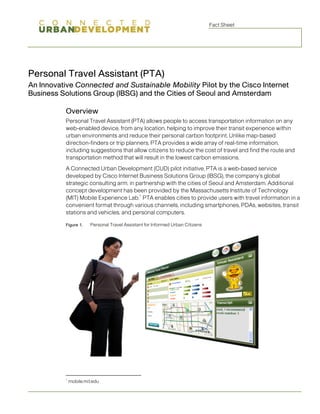
Figure 1. Personal Travel Assistant for Informed Urban Citizens
1
mobile.mit.edu
2. Fact Sheet
The Seoul PTA pilot will be launched in Seoul, South Korea, in conjunction with the Third
Connected Urban Development Conference on May 21-22, 2009. Seoul is one of seven
cities partnering in the Connected Urban Development program, along with Amsterdam,
Birmingham (England), Hamburg, Lisbon, Madrid, and San Francisco. Cisco IBSG worked
with Seoul to develop PTA, with parallel development taking place in partnership with the city
of Amsterdam. Initially, Seoul PTA will serve the Jung-gu and Jongno-gu districts of Seoul;
citywide coverage will roll out later in the year.
Seoul PTA is available at pta.seoul.go.kr, which can be accessed from any IP-enabled
2
device.
Key Features
Seoul PTA incorporates “virtual assistant” features that provide transit guidance based on
user preferences and trip context (for instance, whether time is more critical than expense
for a particular trip), employing real-time traffic and public transportation information. PTA
consists of four key features:
Figure 2. Seoul PTA Shows Planned Personal Travel with Real-Time Traffic Information
• Personal Travel Planner: PTA offers a personal activity scheduler that enables
citizens to reduce the duration, costs, and carbon impact of their transportation
choices—all based on user profile and context. Daily travel often consists of one or
more trips. Each trip may involve using different transportation modes, such as
driving the car to the train station, taking the train to a particular depot, and catching a
bus that stops near the workplace. Personal Travel Planner helps citizens select
better transportation modes for each trip segment based on user preferences,
2
The Seoul PTA service is available online free of charge. Access from mobile devices may be subject to service
provider charges.
Page 2
3. Fact Sheet
available transportation options, and the expected duration, distance, and carbon
emissions of the planned trip.
Figure 3. PTA Real-Time Trip Router Shows Citizens Greener Transit Alternatives
• Carbon Calculator: PTA informs users about the distance, cost, and carbon footprint
of their travel activities—on a daily, weekly, monthly, and yearly basis. PTA estimates
the carbon emissions of each planned trip based on two factors: (1) the average
speed used to reach a given destination by each transportation mode, and (2) the
tier-3 greenhouse gas calculation logic suggested by the Intergovernmental Panel
on Climate Change (IPCC). The carbon calculator stores users’ travel distance and
carbon emissions so they can view and manage their carbon footprint and travel
modes.
Page 3
4. Fact Sheet
Figure 4. PTA Shows Tie-Ups and Alternative Routes in Real Time
• Real-Time Router: PTA allows citizens to find alternative routes based on real-time
traffic information and their current location. If a traffic accident occurs while a user is
in transit, for example, the service will remember the trip’s origin and destination, and
reroute proactively. Using electronic maps, PTA offers information about nearby
parking, public transportation stops/stations, and specific destinations. It also
provides available transportation modes with trip routes, a recommendation for the
fastest option, and an estimate of carbon emissions from current location to
destination.
• Transportation Information Service: PTA provides public transportation route maps
and schedule information with convenient search options. Citizens gain enhanced
visibility into public transportation (for example, when the next bus will arrive at a stop
or station), making their overall travel experience more predictable and enjoyable.
A more detailed feature set for the PTA service is outlined in Table 1:
Page 4
5. Fact Sheet
Table 1. PTA Feature Set for Pilot
Feature Description
Route and schedule information Provides public transportation (bus, subway, etc.), route
maps, and schedule information using easy search
features.
Current travel conditions, alerts, Offers real-time information on roadway and transit
and avoidance conditions; provides alerts when special problems
develop on intended routes and recommends
alternatives.
Travel optimization Optimizes travel planning to minimize time and
transportation/environmental costs based on user profile
and context.
Transit vehicle arrival Provides real-time information on when the next transit
vehicle will arrive at a stop or station.
Mapping and guidance Offers information about nearby parking (automobile and
bicycle), public transportation stops/stations, and
destinations.
Real-time location information Uses electronic maps to tell individuals where they are;
provides a record of personal mobility carbon footprint.
User travel analysis Informs users of their travel activity in kilometers/miles,
costs, and impacts (CO2 emissions).
System analysis Provides information on when, where, and how people
travel to facilitate transportation planning.
Source: Cisco IBSG Connected Urban Development and Victoria Transport Policy Institute, 2008.
Future versions will include additional features, such as enhanced bus transit information,
including bus speed; integration with Smart Transport Payment; integration with real-time
parking lot information; and carbon mileage point conversion into T-money, Seoul's smart
transportation e-payment card.
An Urban Services Platform Approach
CUD ultimately envisions PTA as part of a global urban services platform approach for—
and among—cities. Services will include, but are not limited to: citizen engagement;
collaboration; community-building; professional geo-referential data; real-time
environmental and energy metering and monitoring; simulations for real estate development;
transportation planning; location marketing; and city scenario planning. Incorporating PTA
into this platform will enable cities to optimize citizen services over time, encourage adoption
of alternatives to road travel—whether public transportation or IP-based “smart work”
options—and provide a catalyst for local services innovation, all with a goal of enhancing
economic development and carbon reduction initiatives.
Citizen Benefits
PTA’s goal is to help citizens improve quality of life by transforming urban mobility and
transportation patterns. PTA allows citizens to see the impact of their mobility-change
activities, while also motivating people to manage their personal carbon footprint:
Page 5
6. Fact Sheet
• Provides the ability to easily balance alternatives and make more informed decisions
on day-to-day travel activities, whether for commuting, offsite meetings, or personal
activities
• Empowers citizens by enabling them to make better decisions about their travel
options, based on time, cost, and carbon impact
• Reduces unnecessary travel time and increases productivity
Policymaker Benefits
PTA enhances the ability of city leaders and agencies to manage the urban environment and
transportation system, while boosting citizen engagement:
• Empowers cities with a tool to increase citizens’ participation in transportation
management programs
• Improves city planning through greater understanding of citizens’ transportation
alternatives and trends, and provides data about the impact of citizens’ transit
decisions in terms of usage, cost, and carbon impact
• Helps city managers improve citizen transit experience and reduce carbon
emissions
• Improves the city’s quality of life and helps increase its attractiveness
• Encourages citizens to replace personal car travel with low-carbon transportation
alternatives
• Increases asset/capital management and utilization (and, as a result, road capacity),
eliminating the need to add infrastructure capacity
• Helps enable a more relevant services offering—especially for on-demand services
such as parking and public transportation
• Provides a technology platform for the incubation and creation of local technology
and services, aiding economic development
Partners
PTA is a collaborative effort among the following partners:
• Cisco
• City of Amsterdam
• City of Seoul
• MIT Mobile Experience Lab
• Victoria Transport Policy Institute
• Y&H Engineering & Consulting Ltd.
Page 6
7. Fact Sheet
Background
In recognition of the profound trends of urbanization, climate change, and innovation at the
st
beginning of the 21 century, Connected Urban Development (CUD) was born from Cisco's
commitment to the Clinton Global Initiative to participate in helping reduce carbon
emissions in cities. Launched at the end of 2006, CUD consists of building partnerships with
cities worldwide to focus on using the network as the platform, applying information and
communications technology (ICT) to promote innovative practices for reducing carbon
emissions, while fostering economic growth and improving the quality of life. Innovation is
transforming urban life, and is making it possible to design and manage cities in radically
different ways. With the advance of broadband, wireless, and increasingly smart city
infrastructures, collaboration and connectivity are becoming essential to urban sustainability.
CUD envisions that the same principles of openness that have made the Internet a thriving
ecosystem over the past 20 years can be applied to make cities a smarter platform for
people, products, and services. This global, open-standards approach will support all urban
and natural environment-related applications, tools, and technologies. It will provide real-
time, tangible information to enable citizens, communities, cities, countries, and business
organizations to make smarter decisions and to develop policies that improve the
sustainability of cities. Following are the program’s urban technology principles:
• Wired communications provide infrastructure
• Wireless communications provide mobility
• Miniaturized, inexpensive electronic devices provide access points everywhere
• Digital memory and processing power provide intelligence everywhere
• Software and online content provide new functionality and services
For more information, please visit the Connected Urban Development community website at
http://www.connectedurbandevelopment.org/.
Page 7