SlideShare une entreprise Scribd logo
1  sur  46
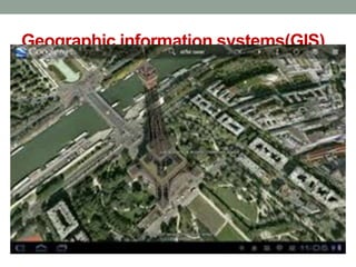
Geographic information systems(GIS)
DEFINITION
An organised collection of computer hardware,
software, geographical data and personnel designed to
efficiently capture, store, update, manipulate, analyze &
display all forms of geographically referenced information.
GIS
• Gives spatial information
• Two types of data:
Spatial data
Non spatial data
GIS map
Spatial data
• Depicted as point, line or a polygon feature
Non spatial data
 Attributes stored in a table as numbers or characters
Storing data
• Vector formats- linear feature
• Raster formats- stored as image- looks real. Line, polygon
and point features
• GIS takes care of features, attributes and layers.
Applications of GIS
• Agrl development
• Vegetative cover
• Crop acreage and production estimation
• Wasteland mapping
• Forest area mapping
• soil resources mapping
• Ground water potential mapping etc…
Trends in GIS
oNRM
• Watershed Delineation
• Waste land demarcation
• Ground water resources
• Identifying water bodies
• Disaster areas
Modern tools for planning watersheds
• DEM map( Digital Elevation Model)
to represent continually varying surface by isolines
or contours.
Global system – WGS 84
In India - LCC
Web portals – Google earth, Bhuvan(ISRO)
Co ordinates taken in UTM plane
India falls in 43, 44, 45,46 planes
DEM
DEM
Images on GIS
REMOTE SENSING
Remote sensing
• Technique of obtaining information about an object
through analysis of data collected without coming in touch
with the object.
Stages in RS
• Emission of EMR
• Transmission, absorption and scattering of energy from
source to earth’s surface
• Interaction of EMR with earth surface
• Transmission of energy from surface to remote sensor
• Data output transmission, processing and analysis
Basic hypothesis
• Any object on earth is having a unique spectral signature
This helps to distinguish one object from another
The Electromagnetic Spectrum
What is Light?
What is Colour?
Why Do We See Colour?
after Campbell, J.B., 1987. Introduction to Remote Sensing. New York: Guildford.
near IRblue green red
Spectral Bands
A fundamental premise in remote
sensing is that we can identify and
learn about objects and features on
the Earth's surface by studying the
spectral characteristics of the
radiation reflected (and/or emitted)
by these features.
Colour Composite Displays
• We typically create multispectral
image displays or colour composite
images by showing different image
bands in varying display
combinations.
True Colour Composites
Standard False Colour Composites
Colour Composite Images
Feature True Colour False Colour
trees and bushes olive green red
crops medium to light green pink to red
wetland vegetation dark green to black dark red
water shades of blue & green blue to black
urban areas white to light blue blue to grey
bare soil white to light grey blue to grey
Source: U.S. Department of Defense, 1995. Multispectral Users Guide.
General Appearance of Surface
Features on Colour Composite Images
What is Spatial Resolution?
• The fineness of spatial detail visible in
an image
• Most affected by contrast
• Determined by the sensor’s
Instantaneous Field of View (IFOV)
• “Resolution”
Low Spatial Resolution
Spatial Resolution: 80 m
File Size: 0.5 Mb
Ground Dimensions: 33 x 33 km
Image Dimensions: 418 x 418
Landsat Multispectral Scanner Image
A
Medium Spatial Resolution
Spatial Resolution: 30 m
File Size: 0.5 Mb
Ground Dimensions: 12.5 x 12.5 km
Image Dimensions: 418 x 418
Image size required to cover area in A:
1.2 Mb (1100 x 1100 )
Landsat Thematic Mapper Image
B
High Spatial Resolution
Spatial Resolution: 1.5 m
File Size: 0.5 Mb
Ground Dimensions: 625 x 625 m
Image Dimensions: 418 x 418
Image size required to cover area in A:
500 Mb (22,300 x 22,300 )
SPIN-2 Panchromatic Image
C
Spatial Resolution: 500 m
Terra MODIS August 24, 2002 NASA Earth Observatory
Spatial Resolution: 30 m
Landsat 7 ETM August 27, 2000
Spatial Resolution: 30 m
Landsat 7 ETM August 27, 2000
Spatial Resolution: 2.4 m
QuickBird 1 September 11, 2002
Spatial Resolution: 0.62 m
QuickBird 1 September 11, 2002
Instantaneous Field of View
Satellites
• Geo stationary satellites
Orbit in synchrony with earth’s rotation
Altitude of 35000km
Mainly for communication and meterology
GEOS,METOSAT, INTELSAT,INSAT
• Sun synchronous satellites
All remote sensing resource satellites
LANDSAT,IRS,CARTOSAT
GLOBAL POSTIONING SYSTEM(GPS)
• GPS is a satellite based radio-navigation system
established by US dept of Defence for military purposes.
• 24 satellites and their ground stations involved.
• Provides information on latitude, longitude,elevation and
direction
GPS
position
• Unique position
corresponding to a reference
system
• WGS 84 (global)
• NAD 83 (US)
• LCC (India)
• NARSTAR satellites are
involved
System
• Handle device
• Satellite
• Ground station
• Processing station
2D position – 3 satellites are involved
3D position – 4 satellites are involved
Remote sensing & gis

Contenu connexe

Tendances

Projections and coordinate system
Projections and coordinate systemProjections and coordinate system
Projections and coordinate systemMohsin Siddique
 
Remote Sensing Data Acquisition,Scanning/Imaging systems
Remote Sensing Data Acquisition,Scanning/Imaging systemsRemote Sensing Data Acquisition,Scanning/Imaging systems
Remote Sensing Data Acquisition,Scanning/Imaging systemsdaniyal rustam
 
Chapter 5: Remote sensing
Chapter 5: Remote sensingChapter 5: Remote sensing
Chapter 5: Remote sensingShankar Gangaju
 
Aerial photography abraham thomas
Aerial photography abraham thomasAerial photography abraham thomas
Aerial photography abraham thomasSumant Diwakar
 
Geo referencing by Mashhood Arif
Geo referencing by Mashhood ArifGeo referencing by Mashhood Arif
Geo referencing by Mashhood ArifKU Leuven
 
Image interpretation keys & image resolution
Image interpretation keys & image resolutionImage interpretation keys & image resolution
Image interpretation keys & image resolutionPramoda Raj
 
Microwave remote sensing
Microwave remote sensingMicrowave remote sensing
Microwave remote sensingRohit Kumar
 
Application of Remote Sensing in Land Use and Land Cover.ppt
Application of Remote Sensing in Land Use and Land Cover.pptApplication of Remote Sensing in Land Use and Land Cover.ppt
Application of Remote Sensing in Land Use and Land Cover.pptKhushbooGodara3
 
Interaction of EMR with atmosphere and earth surface
Interaction of EMR with atmosphere and earth surfaceInteraction of EMR with atmosphere and earth surface
Interaction of EMR with atmosphere and earth surfaceSumant Diwakar
 
Introduction to remote sensing and gis
Introduction to remote sensing and gisIntroduction to remote sensing and gis
Introduction to remote sensing and gisMohsin Siddique
 
Remote sensing - Scanners
Remote sensing - ScannersRemote sensing - Scanners
Remote sensing - ScannersPramoda Raj
 
Thermal Remote Sensing
Thermal Remote SensingThermal Remote Sensing
Thermal Remote SensingRohit Kumar
 
Remote sensing and image interpretation
Remote sensing and image interpretationRemote sensing and image interpretation
Remote sensing and image interpretationMd. Nazir Hossain
 
Geometry of Aerial photograph
Geometry of Aerial photographGeometry of Aerial photograph
Geometry of Aerial photographApoorva Mathur
 

Tendances (20)

Projections and coordinate system
Projections and coordinate systemProjections and coordinate system
Projections and coordinate system
 
Remote sensing
Remote sensingRemote sensing
Remote sensing
 
Remote Sensing Data Acquisition,Scanning/Imaging systems
Remote Sensing Data Acquisition,Scanning/Imaging systemsRemote Sensing Data Acquisition,Scanning/Imaging systems
Remote Sensing Data Acquisition,Scanning/Imaging systems
 
Chapter 5: Remote sensing
Chapter 5: Remote sensingChapter 5: Remote sensing
Chapter 5: Remote sensing
 
Remote sensing
Remote sensingRemote sensing
Remote sensing
 
Aerial photography abraham thomas
Aerial photography abraham thomasAerial photography abraham thomas
Aerial photography abraham thomas
 
Geo referencing by Mashhood Arif
Geo referencing by Mashhood ArifGeo referencing by Mashhood Arif
Geo referencing by Mashhood Arif
 
Digital Elevation Model (DEM)
Digital Elevation Model (DEM)Digital Elevation Model (DEM)
Digital Elevation Model (DEM)
 
Image interpretation keys & image resolution
Image interpretation keys & image resolutionImage interpretation keys & image resolution
Image interpretation keys & image resolution
 
GIS data structure
GIS data structureGIS data structure
GIS data structure
 
GIS data analysis
GIS data analysisGIS data analysis
GIS data analysis
 
Types of stereoscope
Types of stereoscopeTypes of stereoscope
Types of stereoscope
 
Microwave remote sensing
Microwave remote sensingMicrowave remote sensing
Microwave remote sensing
 
Application of Remote Sensing in Land Use and Land Cover.ppt
Application of Remote Sensing in Land Use and Land Cover.pptApplication of Remote Sensing in Land Use and Land Cover.ppt
Application of Remote Sensing in Land Use and Land Cover.ppt
 
Interaction of EMR with atmosphere and earth surface
Interaction of EMR with atmosphere and earth surfaceInteraction of EMR with atmosphere and earth surface
Interaction of EMR with atmosphere and earth surface
 
Introduction to remote sensing and gis
Introduction to remote sensing and gisIntroduction to remote sensing and gis
Introduction to remote sensing and gis
 
Remote sensing - Scanners
Remote sensing - ScannersRemote sensing - Scanners
Remote sensing - Scanners
 
Thermal Remote Sensing
Thermal Remote SensingThermal Remote Sensing
Thermal Remote Sensing
 
Remote sensing and image interpretation
Remote sensing and image interpretationRemote sensing and image interpretation
Remote sensing and image interpretation
 
Geometry of Aerial photograph
Geometry of Aerial photographGeometry of Aerial photograph
Geometry of Aerial photograph
 

Similaire à Remote sensing & gis

MODULE VII_ Remote Sensing_Avantika.pptx
MODULE VII_ Remote Sensing_Avantika.pptxMODULE VII_ Remote Sensing_Avantika.pptx
MODULE VII_ Remote Sensing_Avantika.pptxavantikaadhruj1
 
Introduction of GIS & Remote Sensing (RS)
Introduction of GIS & Remote Sensing (RS)Introduction of GIS & Remote Sensing (RS)
Introduction of GIS & Remote Sensing (RS)Subtain Hussain Syed
 
Remote Sensing and GIS techniques.pptx
Remote Sensing and GIS techniques.pptxRemote Sensing and GIS techniques.pptx
Remote Sensing and GIS techniques.pptxDebashisSatapathy2
 
Image classification and land cover mapping
Image classification and land cover mappingImage classification and land cover mapping
Image classification and land cover mappingKabir Uddin
 
Geographic information system(GIS) and its applications in agriculture
Geographic information system(GIS) and its applications in agricultureGeographic information system(GIS) and its applications in agriculture
Geographic information system(GIS) and its applications in agricultureKiranmai nalla
 
RS_GIS_Crop_monitoring-converted.pptx
RS_GIS_Crop_monitoring-converted.pptxRS_GIS_Crop_monitoring-converted.pptx
RS_GIS_Crop_monitoring-converted.pptxSouvikPal60
 
Basic of gis concept and theories
Basic of gis concept and theoriesBasic of gis concept and theories
Basic of gis concept and theoriesMohsin Siddique
 
GIS and Remote sensing CIvil Engg by Mrunmayee
GIS and Remote sensing CIvil Engg by MrunmayeeGIS and Remote sensing CIvil Engg by Mrunmayee
GIS and Remote sensing CIvil Engg by MrunmayeeMrunmayee Manjari
 
RemoteSensing_DeepLearning_v2.pptx
RemoteSensing_DeepLearning_v2.pptxRemoteSensing_DeepLearning_v2.pptx
RemoteSensing_DeepLearning_v2.pptxElise Colin
 
RS - Presentation by AP2023.pptx
RS - Presentation by AP2023.pptxRS - Presentation by AP2023.pptx
RS - Presentation by AP2023.pptxDrAbhishekPandey9
 
2015 FOSS4G Track: Analyzing Aspen's Community Forest with Lidar, Object-Base...
2015 FOSS4G Track: Analyzing Aspen's Community Forest with Lidar, Object-Base...2015 FOSS4G Track: Analyzing Aspen's Community Forest with Lidar, Object-Base...
2015 FOSS4G Track: Analyzing Aspen's Community Forest with Lidar, Object-Base...GIS in the Rockies
 
GEOGRAPHIC INFORMATION SYSTEM (GIS) & REMOTE SENSING (RS)
GEOGRAPHIC  INFORMATION  SYSTEM (GIS)  & REMOTE SENSING  (RS)GEOGRAPHIC  INFORMATION  SYSTEM (GIS)  & REMOTE SENSING  (RS)
GEOGRAPHIC INFORMATION SYSTEM (GIS) & REMOTE SENSING (RS)Harish kumar Lekkala
 
Image characterisation & aerial photographic film technology
Image characterisation & aerial photographic film technologyImage characterisation & aerial photographic film technology
Image characterisation & aerial photographic film technologypritiverma34
 
Exploring DEM error with geographically weighted regression
Exploring DEM error with geographically weighted regressionExploring DEM error with geographically weighted regression
Exploring DEM error with geographically weighted regressionGeoCommunity
 
Digital Soil Mapping/ Pedomterics
Digital Soil Mapping/ Pedomterics Digital Soil Mapping/ Pedomterics
Digital Soil Mapping/ Pedomterics Soils FAO-GSP
 
Carmon remote sensinggis
Carmon remote sensinggisCarmon remote sensinggis
Carmon remote sensinggisnavdeepjamwal
 

Similaire à Remote sensing & gis (20)

MODULE VII_ Remote Sensing_Avantika.pptx
MODULE VII_ Remote Sensing_Avantika.pptxMODULE VII_ Remote Sensing_Avantika.pptx
MODULE VII_ Remote Sensing_Avantika.pptx
 
Lodha govardhan
Lodha govardhanLodha govardhan
Lodha govardhan
 
Introduction of GIS & Remote Sensing (RS)
Introduction of GIS & Remote Sensing (RS)Introduction of GIS & Remote Sensing (RS)
Introduction of GIS & Remote Sensing (RS)
 
Using LiDAR to Map Sinkholes (EPAN09)
Using LiDAR to Map Sinkholes (EPAN09)Using LiDAR to Map Sinkholes (EPAN09)
Using LiDAR to Map Sinkholes (EPAN09)
 
Remote Sensing and GIS techniques.pptx
Remote Sensing and GIS techniques.pptxRemote Sensing and GIS techniques.pptx
Remote Sensing and GIS techniques.pptx
 
Image classification and land cover mapping
Image classification and land cover mappingImage classification and land cover mapping
Image classification and land cover mapping
 
Geographic information system(GIS) and its applications in agriculture
Geographic information system(GIS) and its applications in agricultureGeographic information system(GIS) and its applications in agriculture
Geographic information system(GIS) and its applications in agriculture
 
RS_GIS_Crop_monitoring-converted.pptx
RS_GIS_Crop_monitoring-converted.pptxRS_GIS_Crop_monitoring-converted.pptx
RS_GIS_Crop_monitoring-converted.pptx
 
Basic of gis concept and theories
Basic of gis concept and theoriesBasic of gis concept and theories
Basic of gis concept and theories
 
GIS and Remote sensing CIvil Engg by Mrunmayee
GIS and Remote sensing CIvil Engg by MrunmayeeGIS and Remote sensing CIvil Engg by Mrunmayee
GIS and Remote sensing CIvil Engg by Mrunmayee
 
RemoteSensing_DeepLearning_v2.pptx
RemoteSensing_DeepLearning_v2.pptxRemoteSensing_DeepLearning_v2.pptx
RemoteSensing_DeepLearning_v2.pptx
 
RS - Presentation by AP2023.pptx
RS - Presentation by AP2023.pptxRS - Presentation by AP2023.pptx
RS - Presentation by AP2023.pptx
 
2015 FOSS4G Track: Analyzing Aspen's Community Forest with Lidar, Object-Base...
2015 FOSS4G Track: Analyzing Aspen's Community Forest with Lidar, Object-Base...2015 FOSS4G Track: Analyzing Aspen's Community Forest with Lidar, Object-Base...
2015 FOSS4G Track: Analyzing Aspen's Community Forest with Lidar, Object-Base...
 
GEOGRAPHIC INFORMATION SYSTEM (GIS) & REMOTE SENSING (RS)
GEOGRAPHIC  INFORMATION  SYSTEM (GIS)  & REMOTE SENSING  (RS)GEOGRAPHIC  INFORMATION  SYSTEM (GIS)  & REMOTE SENSING  (RS)
GEOGRAPHIC INFORMATION SYSTEM (GIS) & REMOTE SENSING (RS)
 
Image characterisation & aerial photographic film technology
Image characterisation & aerial photographic film technologyImage characterisation & aerial photographic film technology
Image characterisation & aerial photographic film technology
 
Remote Sensing
Remote SensingRemote Sensing
Remote Sensing
 
Exploring DEM error with geographically weighted regression
Exploring DEM error with geographically weighted regressionExploring DEM error with geographically weighted regression
Exploring DEM error with geographically weighted regression
 
Digital Soil Mapping/ Pedomterics
Digital Soil Mapping/ Pedomterics Digital Soil Mapping/ Pedomterics
Digital Soil Mapping/ Pedomterics
 
Carmon remote sensinggis
Carmon remote sensinggisCarmon remote sensinggis
Carmon remote sensinggis
 
GIS & RS
GIS & RSGIS & RS
GIS & RS
 

Plus de Dilin Sathyanath

Plus de Dilin Sathyanath (19)

Precision framing techniques
Precision framing techniquesPrecision framing techniques
Precision framing techniques
 
Santhosh
SanthoshSanthosh
Santhosh
 
Agriculture curriculum 10.08.15
Agriculture curriculum 10.08.15Agriculture curriculum 10.08.15
Agriculture curriculum 10.08.15
 
Nirmal sir presentation
Nirmal sir presentationNirmal sir presentation
Nirmal sir presentation
 
Scert
ScertScert
Scert
 
Subject apporach
Subject apporachSubject apporach
Subject apporach
 
04 handout 04
04 handout 0404 handout 04
04 handout 04
 
03 handout 01
03 handout 0103 handout 01
03 handout 01
 
04 handout 04
04 handout 0404 handout 04
04 handout 04
 
02 child right slide
02 child right slide02 child right slide
02 child right slide
 
Teacher planner
Teacher plannerTeacher planner
Teacher planner
 
Learning outcomes
Learning outcomesLearning outcomes
Learning outcomes
 
01 general approach for vhse curriculum
01 general approach for vhse curriculum01 general approach for vhse curriculum
01 general approach for vhse curriculum
 
01 general approach for vhse curriculum
01 general approach for vhse curriculum01 general approach for vhse curriculum
01 general approach for vhse curriculum
 
Cultivation practices roses
Cultivation practices    rosesCultivation practices    roses
Cultivation practices roses
 
SUDHISH SIR CLASS
SUDHISH SIR CLASSSUDHISH SIR CLASS
SUDHISH SIR CLASS
 
ARUN SIR PRESENTATION AT ANIMATION CENTRE
ARUN SIR PRESENTATION AT ANIMATION CENTREARUN SIR PRESENTATION AT ANIMATION CENTRE
ARUN SIR PRESENTATION AT ANIMATION CENTRE
 
Soil science
Soil scienceSoil science
Soil science
 
An introduction to the new generation pesticides 25 10-2013. new
An introduction to the new generation pesticides 25 10-2013. newAn introduction to the new generation pesticides 25 10-2013. new
An introduction to the new generation pesticides 25 10-2013. new
 

Dernier

Arihant handbook biology for class 11 .pdf
Arihant handbook biology for class 11 .pdfArihant handbook biology for class 11 .pdf
Arihant handbook biology for class 11 .pdfchloefrazer622
 
Incoming and Outgoing Shipments in 1 STEP Using Odoo 17
Incoming and Outgoing Shipments in 1 STEP Using Odoo 17Incoming and Outgoing Shipments in 1 STEP Using Odoo 17
Incoming and Outgoing Shipments in 1 STEP Using Odoo 17Celine George
 
URLs and Routing in the Odoo 17 Website App
URLs and Routing in the Odoo 17 Website AppURLs and Routing in the Odoo 17 Website App
URLs and Routing in the Odoo 17 Website AppCeline George
 
SOCIAL AND HISTORICAL CONTEXT - LFTVD.pptx
SOCIAL AND HISTORICAL CONTEXT - LFTVD.pptxSOCIAL AND HISTORICAL CONTEXT - LFTVD.pptx
SOCIAL AND HISTORICAL CONTEXT - LFTVD.pptxiammrhaywood
 
How to Make a Pirate ship Primary Education.pptx
How to Make a Pirate ship Primary Education.pptxHow to Make a Pirate ship Primary Education.pptx
How to Make a Pirate ship Primary Education.pptxmanuelaromero2013
 
Introduction to ArtificiaI Intelligence in Higher Education
Introduction to ArtificiaI Intelligence in Higher EducationIntroduction to ArtificiaI Intelligence in Higher Education
Introduction to ArtificiaI Intelligence in Higher Educationpboyjonauth
 
Kisan Call Centre - To harness potential of ICT in Agriculture by answer farm...
Kisan Call Centre - To harness potential of ICT in Agriculture by answer farm...Kisan Call Centre - To harness potential of ICT in Agriculture by answer farm...
Kisan Call Centre - To harness potential of ICT in Agriculture by answer farm...Krashi Coaching
 
Solving Puzzles Benefits Everyone (English).pptx
Solving Puzzles Benefits Everyone (English).pptxSolving Puzzles Benefits Everyone (English).pptx
Solving Puzzles Benefits Everyone (English).pptxOH TEIK BIN
 
Accessible design: Minimum effort, maximum impact
Accessible design: Minimum effort, maximum impactAccessible design: Minimum effort, maximum impact
Accessible design: Minimum effort, maximum impactdawncurless
 
Grant Readiness 101 TechSoup and Remy Consulting
Grant Readiness 101 TechSoup and Remy ConsultingGrant Readiness 101 TechSoup and Remy Consulting
Grant Readiness 101 TechSoup and Remy ConsultingTechSoup
 
Separation of Lanthanides/ Lanthanides and Actinides
Separation of Lanthanides/ Lanthanides and ActinidesSeparation of Lanthanides/ Lanthanides and Actinides
Separation of Lanthanides/ Lanthanides and ActinidesFatimaKhan178732
 
Paris 2024 Olympic Geographies - an activity
Paris 2024 Olympic Geographies - an activityParis 2024 Olympic Geographies - an activity
Paris 2024 Olympic Geographies - an activityGeoBlogs
 
Organic Name Reactions for the students and aspirants of Chemistry12th.pptx
Organic Name Reactions  for the students and aspirants of Chemistry12th.pptxOrganic Name Reactions  for the students and aspirants of Chemistry12th.pptx
Organic Name Reactions for the students and aspirants of Chemistry12th.pptxVS Mahajan Coaching Centre
 
PSYCHIATRIC History collection FORMAT.pptx
PSYCHIATRIC   History collection FORMAT.pptxPSYCHIATRIC   History collection FORMAT.pptx
PSYCHIATRIC History collection FORMAT.pptxPoojaSen20
 
Concept of Vouching. B.Com(Hons) /B.Compdf
Concept of Vouching. B.Com(Hons) /B.CompdfConcept of Vouching. B.Com(Hons) /B.Compdf
Concept of Vouching. B.Com(Hons) /B.CompdfUmakantAnnand
 
Introduction to AI in Higher Education_draft.pptx
Introduction to AI in Higher Education_draft.pptxIntroduction to AI in Higher Education_draft.pptx
Introduction to AI in Higher Education_draft.pptxpboyjonauth
 
Crayon Activity Handout For the Crayon A
Crayon Activity Handout For the Crayon ACrayon Activity Handout For the Crayon A
Crayon Activity Handout For the Crayon AUnboundStockton
 

Dernier (20)

Arihant handbook biology for class 11 .pdf
Arihant handbook biology for class 11 .pdfArihant handbook biology for class 11 .pdf
Arihant handbook biology for class 11 .pdf
 
Incoming and Outgoing Shipments in 1 STEP Using Odoo 17
Incoming and Outgoing Shipments in 1 STEP Using Odoo 17Incoming and Outgoing Shipments in 1 STEP Using Odoo 17
Incoming and Outgoing Shipments in 1 STEP Using Odoo 17
 
URLs and Routing in the Odoo 17 Website App
URLs and Routing in the Odoo 17 Website AppURLs and Routing in the Odoo 17 Website App
URLs and Routing in the Odoo 17 Website App
 
Staff of Color (SOC) Retention Efforts DDSD
Staff of Color (SOC) Retention Efforts DDSDStaff of Color (SOC) Retention Efforts DDSD
Staff of Color (SOC) Retention Efforts DDSD
 
SOCIAL AND HISTORICAL CONTEXT - LFTVD.pptx
SOCIAL AND HISTORICAL CONTEXT - LFTVD.pptxSOCIAL AND HISTORICAL CONTEXT - LFTVD.pptx
SOCIAL AND HISTORICAL CONTEXT - LFTVD.pptx
 
How to Make a Pirate ship Primary Education.pptx
How to Make a Pirate ship Primary Education.pptxHow to Make a Pirate ship Primary Education.pptx
How to Make a Pirate ship Primary Education.pptx
 
Introduction to ArtificiaI Intelligence in Higher Education
Introduction to ArtificiaI Intelligence in Higher EducationIntroduction to ArtificiaI Intelligence in Higher Education
Introduction to ArtificiaI Intelligence in Higher Education
 
Model Call Girl in Bikash Puri Delhi reach out to us at 🔝9953056974🔝
Model Call Girl in Bikash Puri  Delhi reach out to us at 🔝9953056974🔝Model Call Girl in Bikash Puri  Delhi reach out to us at 🔝9953056974🔝
Model Call Girl in Bikash Puri Delhi reach out to us at 🔝9953056974🔝
 
Kisan Call Centre - To harness potential of ICT in Agriculture by answer farm...
Kisan Call Centre - To harness potential of ICT in Agriculture by answer farm...Kisan Call Centre - To harness potential of ICT in Agriculture by answer farm...
Kisan Call Centre - To harness potential of ICT in Agriculture by answer farm...
 
Solving Puzzles Benefits Everyone (English).pptx
Solving Puzzles Benefits Everyone (English).pptxSolving Puzzles Benefits Everyone (English).pptx
Solving Puzzles Benefits Everyone (English).pptx
 
Accessible design: Minimum effort, maximum impact
Accessible design: Minimum effort, maximum impactAccessible design: Minimum effort, maximum impact
Accessible design: Minimum effort, maximum impact
 
Grant Readiness 101 TechSoup and Remy Consulting
Grant Readiness 101 TechSoup and Remy ConsultingGrant Readiness 101 TechSoup and Remy Consulting
Grant Readiness 101 TechSoup and Remy Consulting
 
Separation of Lanthanides/ Lanthanides and Actinides
Separation of Lanthanides/ Lanthanides and ActinidesSeparation of Lanthanides/ Lanthanides and Actinides
Separation of Lanthanides/ Lanthanides and Actinides
 
Paris 2024 Olympic Geographies - an activity
Paris 2024 Olympic Geographies - an activityParis 2024 Olympic Geographies - an activity
Paris 2024 Olympic Geographies - an activity
 
Organic Name Reactions for the students and aspirants of Chemistry12th.pptx
Organic Name Reactions  for the students and aspirants of Chemistry12th.pptxOrganic Name Reactions  for the students and aspirants of Chemistry12th.pptx
Organic Name Reactions for the students and aspirants of Chemistry12th.pptx
 
PSYCHIATRIC History collection FORMAT.pptx
PSYCHIATRIC   History collection FORMAT.pptxPSYCHIATRIC   History collection FORMAT.pptx
PSYCHIATRIC History collection FORMAT.pptx
 
Concept of Vouching. B.Com(Hons) /B.Compdf
Concept of Vouching. B.Com(Hons) /B.CompdfConcept of Vouching. B.Com(Hons) /B.Compdf
Concept of Vouching. B.Com(Hons) /B.Compdf
 
Model Call Girl in Tilak Nagar Delhi reach out to us at 🔝9953056974🔝
Model Call Girl in Tilak Nagar Delhi reach out to us at 🔝9953056974🔝Model Call Girl in Tilak Nagar Delhi reach out to us at 🔝9953056974🔝
Model Call Girl in Tilak Nagar Delhi reach out to us at 🔝9953056974🔝
 
Introduction to AI in Higher Education_draft.pptx
Introduction to AI in Higher Education_draft.pptxIntroduction to AI in Higher Education_draft.pptx
Introduction to AI in Higher Education_draft.pptx
 
Crayon Activity Handout For the Crayon A
Crayon Activity Handout For the Crayon ACrayon Activity Handout For the Crayon A
Crayon Activity Handout For the Crayon A
 

Remote sensing & gis

  • 2. Geographic information systems(GIS) DEFINITION An organised collection of computer hardware, software, geographical data and personnel designed to efficiently capture, store, update, manipulate, analyze & display all forms of geographically referenced information.
  • 3. GIS • Gives spatial information • Two types of data: Spatial data Non spatial data
  • 4. GIS map Spatial data • Depicted as point, line or a polygon feature Non spatial data  Attributes stored in a table as numbers or characters
  • 5. Storing data • Vector formats- linear feature • Raster formats- stored as image- looks real. Line, polygon and point features • GIS takes care of features, attributes and layers.
  • 6. Applications of GIS • Agrl development • Vegetative cover • Crop acreage and production estimation • Wasteland mapping • Forest area mapping • soil resources mapping • Ground water potential mapping etc…
  • 7. Trends in GIS oNRM • Watershed Delineation • Waste land demarcation • Ground water resources • Identifying water bodies • Disaster areas
  • 8. Modern tools for planning watersheds • DEM map( Digital Elevation Model) to represent continually varying surface by isolines or contours. Global system – WGS 84 In India - LCC Web portals – Google earth, Bhuvan(ISRO) Co ordinates taken in UTM plane India falls in 43, 44, 45,46 planes
  • 9.
  • 10. DEM
  • 11. DEM
  • 14. Remote sensing • Technique of obtaining information about an object through analysis of data collected without coming in touch with the object.
  • 15. Stages in RS • Emission of EMR • Transmission, absorption and scattering of energy from source to earth’s surface • Interaction of EMR with earth surface • Transmission of energy from surface to remote sensor • Data output transmission, processing and analysis
  • 16.
  • 17. Basic hypothesis • Any object on earth is having a unique spectral signature This helps to distinguish one object from another
  • 21. Why Do We See Colour? after Campbell, J.B., 1987. Introduction to Remote Sensing. New York: Guildford.
  • 22. near IRblue green red Spectral Bands
  • 23. A fundamental premise in remote sensing is that we can identify and learn about objects and features on the Earth's surface by studying the spectral characteristics of the radiation reflected (and/or emitted) by these features.
  • 24. Colour Composite Displays • We typically create multispectral image displays or colour composite images by showing different image bands in varying display combinations.
  • 25.
  • 27.
  • 28. Standard False Colour Composites
  • 31. Feature True Colour False Colour trees and bushes olive green red crops medium to light green pink to red wetland vegetation dark green to black dark red water shades of blue & green blue to black urban areas white to light blue blue to grey bare soil white to light grey blue to grey Source: U.S. Department of Defense, 1995. Multispectral Users Guide. General Appearance of Surface Features on Colour Composite Images
  • 32. What is Spatial Resolution? • The fineness of spatial detail visible in an image • Most affected by contrast • Determined by the sensor’s Instantaneous Field of View (IFOV) • “Resolution”
  • 33. Low Spatial Resolution Spatial Resolution: 80 m File Size: 0.5 Mb Ground Dimensions: 33 x 33 km Image Dimensions: 418 x 418 Landsat Multispectral Scanner Image A
  • 34. Medium Spatial Resolution Spatial Resolution: 30 m File Size: 0.5 Mb Ground Dimensions: 12.5 x 12.5 km Image Dimensions: 418 x 418 Image size required to cover area in A: 1.2 Mb (1100 x 1100 ) Landsat Thematic Mapper Image B
  • 35. High Spatial Resolution Spatial Resolution: 1.5 m File Size: 0.5 Mb Ground Dimensions: 625 x 625 m Image Dimensions: 418 x 418 Image size required to cover area in A: 500 Mb (22,300 x 22,300 ) SPIN-2 Panchromatic Image C
  • 36. Spatial Resolution: 500 m Terra MODIS August 24, 2002 NASA Earth Observatory
  • 37. Spatial Resolution: 30 m Landsat 7 ETM August 27, 2000
  • 38. Spatial Resolution: 30 m Landsat 7 ETM August 27, 2000
  • 39. Spatial Resolution: 2.4 m QuickBird 1 September 11, 2002
  • 40. Spatial Resolution: 0.62 m QuickBird 1 September 11, 2002
  • 42. Satellites • Geo stationary satellites Orbit in synchrony with earth’s rotation Altitude of 35000km Mainly for communication and meterology GEOS,METOSAT, INTELSAT,INSAT • Sun synchronous satellites All remote sensing resource satellites LANDSAT,IRS,CARTOSAT
  • 43. GLOBAL POSTIONING SYSTEM(GPS) • GPS is a satellite based radio-navigation system established by US dept of Defence for military purposes. • 24 satellites and their ground stations involved. • Provides information on latitude, longitude,elevation and direction
  • 44. GPS position • Unique position corresponding to a reference system • WGS 84 (global) • NAD 83 (US) • LCC (India) • NARSTAR satellites are involved
  • 45. System • Handle device • Satellite • Ground station • Processing station 2D position – 3 satellites are involved 3D position – 4 satellites are involved

Notes de l'éditeur

  1. 36
  2. 38