Qlikview Quick Map Charts
•Télécharger en tant que PPTX, PDF•
5 j'aime•11,345 vues

Learn how to create map charts in Qlikview in just minutes.

Recommandé
Contenu connexe
Dernier
Dernier (20)
En vedette
En vedette (20)
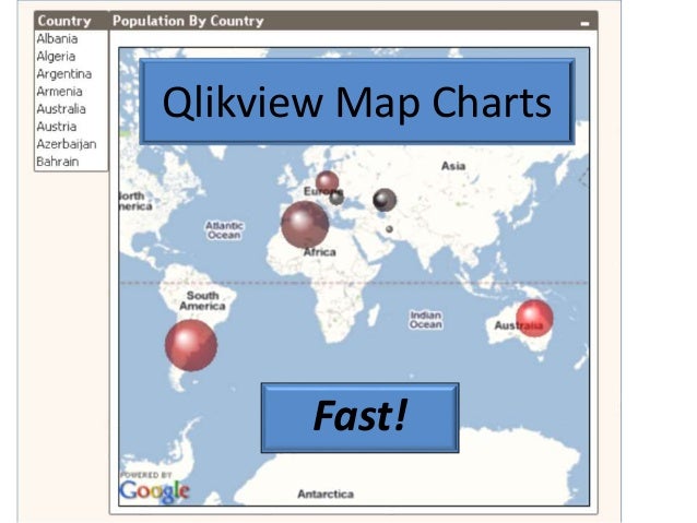
Qlikview Quick Map Charts
- 2. Chart Data Like This In Minutes
- 3. Easy Instructions: 1 - Download Free Qlikview 9 At: http://www.qlikview.com/us/explore/experien ce/free-download 2 - Install Qlikview
- 4. Fire up Qlikview – Getting Started Scroll Down
- 6. You Just Opened A Qlikview Document Containing The Maps Example Click On The Tutorials Tab
- 8. Click ‘File’
- 9. Click ‘New’
- 10. You Have Now Opened A New Qlikview Document • Press F12 to save the document • We’ll copy some text for a script and • Then Press Control-E To Create A Load Script
- 11. Then, Copy This Text - We’ll Need It In A Minute Data: LOAD * INLINE [ Country, Population, GDP_PPP_M, latitude, longitude Albania, 3600523, 19621, 41.153332, 20.168331 Algeria, 33858000, 269201, 28.033886, 1.659626 Argentina, 40301927, 523169, -38.416097, -63.616672 Armenia, 3230100, 17139, 40.069099, 45.038189 Australia, 21446187, 760800, -25.274398, 133.775136 Austria, 8340924, 317800, 47.516231, 14.550072 Azerbaijan, 8629900, 64082, 40.143105, 47.576927 Bahrain, 760168, 24245, 25.930414, 50.637772 ];
- 12. In Qlikview Press ‘Control-E’ You Should See This:
- 13. Paste The Copied Text Here:
- 14. Then, Copy This Text // Google Maps in QlikView // V0.9 - October 1st 2008 © Copyright QlikTech International AB 2008 / AES // Google Maps Key // get a key here http://code.google.com/apis/maps/signup.html gmap_key = 'xx'; max_zoom_level = 5; //maximum value 17 // Variables required for calculating map // No need to change these var_pi180= '=pi()/180'; var_lat_offset='0'; var_mc2= '=256*pow(2,$(var_zoom))'; var_mc1= '=256*pow(2,($(var_zoom)-1))'; var_mid_lat= '=min(latitude)+(1+var_lat_offset)*((max(latitude)-min(latitude))/2)'; var_mid_long= '=min(longitude)+(max(longitude)-min(longitude))/2'; var_zoom= '=max(aggr(if(max( round(256*pow(2,(_zoom_level -1)))+( longitude *((256*pow(2,_zoom_level ))/360)) )-min( round(256*pow(2,(_zoom_level -1)))+( longitude *((256*pow(2,_zoom_level ))/360)) ) <map_size_x AND max((256*pow(2,(_zoom_level-1)))+((0.5*log((1+(sin((latitude)*pi()/180)))/(1-(sin((latitude)*pi()/180)))))*((- 256*pow(2,_zoom_level))/(2*pi()))))-min((256*pow(2,(_zoom_level-1)))+((0.5*log((1+(sin((latitude)*pi()/180)))/(1- (sin((latitude)*pi()/180)))))*((-256*pow(2,_zoom_level))/(2*pi()))))<map_size_y,_zoom_level,1),_zoom_level))'; var_maptype= '=if(isnull(only(maptype)),fieldvalue( '&chr(39)&'maptype'&chr(39)&', 1 ),maptype)'; map_size_x= '400'; map_size_y= '400'; SET HidePrefix='_' ; // Field required for calcualting best zoom level _zoom_level: Load RecNo( ) as _zoom_level autogenerate(max_zoom_level); maptype: LOAD * INLINE [ maptype roadmap mobile satellite terrain hybrid ];
- 15. Paste The Copied Text Here:
- 16. Click ‘Reload’
- 17. Qlikview Loads Our Data And Displays This: Click Country Then, Click Add
- 19. We Now Have A List Box For Country Switch Back To The Map Example Doc By Clicking Window
- 20. Select The Map Example Doc
- 21. Then We Need To Copy A Map Chart Right Click Map And Pick Object From Menus
- 22. Switch Back To Your Map Document Select Your Map Document
- 23. Paste In The Copied Chart Object Click Edit Then Paste
- 24. And Here’s Your New Chart Bigger Circles For Bigger Populations
- 25. Selecting Just One Country Zooms In The Map
- 26. Selecting More Zooms Out Hovering The Cursor Shows A Pop Up
- 27. Amazingly Fast Map Charts Check Out More Tutorials At: http://www.DavidHubbard.net