Landslide graphical analysis
•
2 j'aime•539 vues

USC Marine Campus-Two Harbors Roadway Landslide analysis at Catalina Island, California for Graduate Class in GIST Master's degree program at University of Southern California.

Recommandé
Recommandé
Contenu connexe
En vedette
En vedette (15)
Dernier
Dernier (20)
Landslide graphical analysis
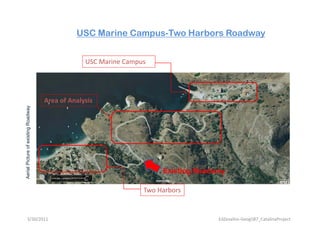
- 1. USC Marine Campus-Two Harbors Roadway USC Marine Campus Area of Analysis xisting Roadway Aeria Picture of ex y Existing Roadway al Two Harbors 3/30/2011 EdZevallos‐Geog587_CatalinaProject
- 2. USC Marine Campus-Two Harbors Roadway Typical drainage structure along existing roadway (only two units) (only two units) 3/30/2011 EdZevallos‐Geog587_CatalinaProject
- 3. USC Marine Campus-Two Harbors Roadway Landslide analysis graphical definition Hypothesis: data collection and analysis of information from existing roadway for road improvements and landslide prevention 3/30/2011 EdZevallos‐Geog587_CatalinaProject
- 4. USC Marine Campus-Two Harbors Roadway Image processing GPS Field GPS Fi ld Survey Web GIS Analysis and interpretation of GIS solutions information 3/30/2011 EdZevallos‐Geog587_CatalinaProject
- 5. USC Marine Campus-Two Harbors Roadway Typical Data information Collected in NOMAD GPS NOMAD GPS software “GPS Pathfinder office” Use of CADD software for delivery of processed information ArcMac Processing of Data 3/30/2011 EdZevallos‐Geog587_CatalinaProject
- 6. USC Marine Campus-Two Harbors Roadway are ADD Software) and Bentley GEOPAK Softwa 3 Existing drainage structure cMAP interactivity with importe info from Arc Located spot sites on previous ere exist andslide ed to la whe Microstation (Bentley CA erosio 1 2 1 Polyline (GPS Trail) info exported from ArcMap and imported to Microstation 2 GEOPAK Software Navigator showing Northing/Easting/Elevation data 3 GEOPAK Software COGO Road showing store imported info from Text File (ArcMap) 3/30/2011 EdZevallos‐Geog587_CatalinaProject
- 7. USC Marine Campus-Two Harbors Roadway ADD Software) generating a profile view (elevations) 2 p ctures of existing drainage struc Microstation (Bentley CA Existing drainage structure g 1 Microstation environment generating graphical info from ArcMap 3/30/2011 EdZevallos‐Geog587_CatalinaProject
- 8. USC Marine Campus-Two Harbors Roadway oadway sheet drawing d PAK Software 2 Existing drainage structure Final Product for landslide analysis. Plan and elevation Ro Bentley CADD Software) and Bentley GEOP ot sites evious xist lide where ex 1 erosion pre Located spo to landsl 3 Microstation (B 1 Polyline (GPS Trail) info exported from ArcMap and imported to Microstation 2 GEOPAK Software Navigator-survey window dialog 3 Generated profile of existing drainage structure 3/30/2011 EdZevallos‐Geog587_CatalinaProject