

Recommandé
Contenu connexe
Tendances
Tendances (20)
En vedette
En vedette (20)
Similaire à Global positioning system (gps)
Similaire à Global positioning system (gps) (20)
Plus de Gokul Saud
Plus de Gokul Saud (19)
Global positioning system (gps)
- 1. 1 Global Positioning System (GPS)
- 2. What is GPS? GPS, which stands for Global Positioning System, is the only system today able to show you your exact position on the Earth anytime, in any weather, anywhere. The three parts of GPS are: •Space Segment •User segment •Ground Control segment
- 3. What is the GPS? Orbiting navigational satellites Transmit position and time data Handheld receivers calculate latitude longitude altitude velocity Developed by Department of Defense
- 4. History of the GPS 1969—Defense Navigation Satellite System (DNSS) formed 1973—NAVSTAR Global Positioning System developed 1978—first 4 satellites launched Delta rocket launch
- 5. History of the GPS 1993—24th satellite launched; initial operational capability 1995—full operational capability May 2000—Military accuracy available to all users
- 6. Components of the System The Space Segment The Control Segment The User Segment
- 7. 7 Components of the System • Space segment • Control segment • User segment
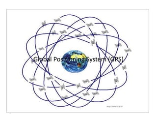
- 9. Components of the System Space segment 24 satellite vehicles Six orbital planes Inclined 55o with respect to equator Orbits separated by 60o 20,200 km elevation above Earth Orbital period of 11 hr 55 min Five to eight satellites visible from any point on Earth Block I Satellite Vehicle
- 11. GPS Satellite Vehicle Four atomic clocks Three nickel-cadmium batteries Two solar panels Battery charging Power generation 1136 watts S band antenna—satellite control 12 element L band antenna—user communication Block IIF satellite vehicle (fourth generation)
- 12. GPS Satellite Vehicle Weight 2370 pounds Height 16.25 feet Width 38.025 feet including wing span Design life—10 years Block IIR satellite vehicle assembly at Lockheed Martin, Valley Forge, PA
- 13. Components of the System User segment GPS antennas & receiver/processors Position Velocity Precise timing Used by Aircraft Ground vehicles Ships Individuals
- 14. Components of the System Ground control segment Master control station Schreiver AFB, Colorado Five monitor stations Three ground antennas Backup control system
- 15. GPS Communication and Control
- 16. GPS Ground Control Stations
- 17. Triangulation Geometric Principle: You can find one location if you know its distance from other, already-known locations. How does Gps Works?
- 18. Triangulation
- 19. Triangulation
- 20. Signal From One Satellite The receiver is somewhere on this sphere.
- 21. Signals From Two Satellites
- 22. Three Satellites (2D Positioning)
- 23. Three Dimensional (3D) Positioning
- 24. 3-D Trilateration 1 Satellite 2 Satellites 3 Satellites
- 25. Sources of Signal Interference Earth’s Atmosphere Solid Structures Metal Electro-magnetic Fields
- 26. Obstruction
- 27. Atomic Clocks GPS satellites use Atomic Clocks for accuracy, but because of the expense, most GPS receivers do not.
- 28. Line of Sight Transmissions Line of sight is the ability to draw a straight line between two objects without any other objects getting in the way. GPS transmission are line-of- sight transmissions. Obstructions such as trees, buildings, or natural formations may prevent clear line of sight.
- 29. Light Refraction Sometimes the GPS signal from the satellite doesn’t follow a straight line. Refraction is the bending of light as it travels through one media to another.
- 30. Signal Refraction Signals from satellites can be like light. When they hit some interference (air patterns in the atmosphere, uneven geography, etc.) they sometimes bend a little.
- 31. Signal Interference Sometimes the signals bounce off things before they hit the receivers.
- 32. Satellite Distribution When the satellites are all in the same part of the sky, readings will be less accurate.
- 33. PDOP All of this combines to make the signal less accurate, and gives it what we call a high “PDOP.” PDOP = Positional Dilution of Precision 11,000 miles 11,000 miles 11,000 miles 11,000 miles •A PDOP of <4 is excellent •A PDOP of 4-8 is good •A PDOP of >8 is poor
- 34. In a Nutshell
- 35. Application of GPS Technology • Location - determining a basic position • Navigation - getting from one location to another • Tracking - monitoring the movement of people and things • Mapping - creating maps of the world • Timing - bringing precise timing to the world