
Recommandé
Recommandé
Contenu connexe
En vedette
En vedette (20)
Dernier
Dernier (20)
Geo-visualization gallery
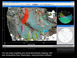
- 1. 3-D rock slope modeling and virtual discontinuity mapping, I-90 near Snoqualmie Pass, Washington, using Sirovision software
- 2. Airborne lidar derived 3-D surface model of the Serpent Mound, Adams County, Ohio colored by slope angle
- 3. Digital elevation model of the Laprak landslide, Gorkha District, Nepal, colored by slope aspect (dip direction)
- 4. Shaded relief image of the Kelang Serai rockslide, India, created from a 90 m SRTM DEM and colored by slope angle (those elevations are in meters, not feet, by the way)
- 5. Finite element simulation showing draping of a poroelastic aquifer and aquitard over a buried bedrock ridge
- 6. Interactive borehole data visualization of rock mass discontinuities at Slide Curve, I-90 near Snoqualmie Pass, Washington
- 7. Influence of bedrock structures on colluvium accumulation, Laprak landslide, Gorkha District, Nepal
- 8. Landsat false color image draped over a digital elevation model of Cincinnati, Ohio and adjacent areas in northern Kentucky
- 9. Shaded relief image of the Tso Moriri area, a region of extensional tectonics in the Indian Transhimalaya, from a 90 m SRTM DEM and colored by topographic roughness
- 10. PISA-m probabilistic slope stability simulations, UCSF Parnassus campus, for wet static and dry seismic conditions draped over a 2 ft lidar DEM