SlideShare une entreprise Scribd logo
1  sur  54
Télécharger pour lire hors ligne
How Does a 21st Century Version of Apartheid Look Like?
Palestine Knows.
Jamal Juma’
Apartheid Wall Campaign/Palestinian Environmental NGOs Network
You can call it a “Separation Wall,” “Isolation Wall,” “Colonial Wall” or, as we call it, “Apartheid
Wall”; but certainly not a “Security Wall.” Yet, none of these names reflect the shocking reality
of what the Wall really is. What may not have been clear to some at the beginning of the Wall’s
construction, when the pretenses and buzzwords of “security” and “fighting terror” were dominant
in the Israeli and global discourse, has recently come to surface; only a few months after the first
Guest Articles
bulldozers began large-scale destruction of Palestinian lands, trees and property, the open public
debate in Israel about how many settlements to annex with the Wall has turned commonplace. The
Wall presents for us the future map of Palestine and the meaning of the kind of lifelessness that
has befallen on Palestinians, on the little that will remain of their lands. All in all, we are witnessing
a 21st century version of Apartheid, which will lay siege to Palestinians within fragmented,
disconnected cantons, taking final possession of the Palestinian right to live in freedom, in a state
like any other people.
Work on the Wall’s “first phase” began in June 2002 in the northern West Bank, starting from the
village of Salem, northwest of the city of Jenin, leading all the way to the village of ‘Azzun ‘Atma
south of Qalqiliya, running the length of about 145 kilometers. In fact, the Wall is not being built
on or even close to the Green Line, even in the case of Qalqiliya city, which is a town bordering
the Green Line, the Wall is built over 150 meters inside the city, adjoining homes and shops,
threatening them with demolition as they lie within the Wall’s 30-100 meter buffer zone. In other
cases, such as in Jayyus, ‘Isla, ‘Azzun and Kafr Sur, the Wall is built between 4-6 kilometers inside
the West Bank; this massive sweep is isolating approximately 11,500 people living in 16 villages
between the Wall and the Green Line, disconnecting them from both the rest of the West Bank and
from Israel. The Wall further isolates the lands from at least 50 additional villages which are located
east of the Wall, while their lands are located west of the Wall.
Alongside large scale confiscation and de facto annexation, thousands of dunums of agricultural
lands and the uprooting of tens of thousands of trees have already taken place. More than
85 commercial stores have been demolished and more than double are awaiting the arrival of
bulldozers, in most cases in order to further isolate West Bank communities near the Green Line
into the non-livable, annexed zone. Hundreds of families have had their lands confiscated or their
properties destroyed. Most of those who have lost land and property because of the Wall have
been left with virtually nothing, awaiting monthly humanitarian assistance when they were, not so
long ago, able to sustain themselves and at times flourish off of their lands and commerce.
But, the “first phase” was nothing more than a “modest” beginning for what would soon follow.
Amidst accelerated threats by the U.S. to attack Iraq in the beginning of 2003, further expansionist
plans simultaneously began to appear, one after another, and in undoubted harmony between
the settlers and their government. In January of this year, the maps that determined the Wall’s
path to be the shocking length of 360 kilometers and that will isolate 95,000 Palestinian from the
West Bank and the 200,000 residents of East Jerusalem from the West Bank would quickly fade.
At the beginning of February 2003, the “Yesha” settler’s council/Israeli government announced
its proposal to make modifications to the Wall’s path in order to annex additional, if not most of
the settlement blocs, some of them, such as the Ariel settlement bloc, are 16 km inside the West
Bank. This new plan, which the Israeli media announced was produced by the settlers in direct
cooperation with the Israeli Ministry of Defense, isolates a total of 405,000 Palestinians and
annexes to Israel 343,000 settlers, dividing the West Bank into two separate blocks north and
south of the Jerusalem area.
In March 2003, Sharon put his final touches on this colonial project, which began in 1967 if not
in 1948, by announcing the building of a second wall in the eastern-central West Bank alongside
the Jordan Valley; thus completing the confinement of an already shredded West Bank while
annexing the settlements in the central West Bank. This plan of walls will divide the West Bank
into three main disconnected residential ghettos; even within these areas communities will further
be isolated from one another. These ghettos will be located at most locations kilometers inside the
1967 borders, as Israel chisels away into the West Bank from all directions. These ghettos are:
The northern ghetto of Nablus, Jenin, Tulkarm; the central ghetto of Salfit and Ramallah; and the
southern ghetto of Bethlehem and Hebron. Qalqiliya and Jericho will each be an open air prison
surrounded by walls from all sides, as well as several other villages to the west of Ramallah and
Salfit, here each group of neighboring villages will fenced in with a single gate leading to the
closest larger ghetto. In total, the ghettos, between the two Walls, comprise 45% of the West Bank
139138
upon which the Palestinian “state” will be established and where some form of connection lines,
like fenced roads and concrete walls, may be provided between these ghettos.
By tearing apart the West Bank in these disconnected areas, the Wall is reshaping the “final status”
of the Palestinian state according to the Zionist project. Through the fortification of these walls
Israel will “achieve” the following:
•First, Israel lays hold over Palestinian lands while surrounding the residential areas in
order to make them unlivable, controling the number of Palestinians able to survive, with
the goal of ensuring for itself a Jewish majority in all of historic Palestine.
•Second, Israel makes certain that no Palestinian state will be viable through the control of
Palestinian water resources and fertile agricultural lands that could otherwise be the base
for any future socio-economical and agricultural development.
•Third, Israel effectively erases the 1967 boarders and redesigns them accordingly to meet
their political ambitions of maintaining full control over the West Bank, as they consider it
the land of “Greater Israel.”
•Fourth, Israel completely isolates Jerusalem from the West Bank through the building of
settlement blocs on all sides, strangling the city whereby no room for Palestinian expansion,
demographically as well as socially and economically, remains. The Wall is the final step of
Israel’s annexation of Jerusalem from the West Bank.
To date, and including the Road Map, there has been no genuine interest by Israel and its partners
in ending this colonial project of dispossession. The first commitment to putting an end to the
colonial project, where the Wall represents the top of the colonial pyramid, is the dismantling of the
Wall and the settlements. A Road Map that deals not with the fundamental, causal issues, negating
the existence of the ’67 borders, relegating Jerusalem insignificant, denying the inalienable rights
of the refugees, and allowing for the continued existence of the settlement project brings about
a legitimate fear of the Palestinian people that such a document will blind the world into seeing
the opposite of what really is. Taking into account the daily “developments” on the ground, marked
by brutal violations and crimes, the Road Map could symbolize not only the Oslo whirlpool but a
momentum that could lead to even further devastation.
Therefore, the Wall should be defined as the last phase of the Zionist colonial project aimed at
the complete control on the West Bank, which began immediately following the Occupation
of the West Bank in 1967 and whose implementation has continued in a well- planned
and organized manner, culminating with the building of a succession of Walls that will
absolutely control the fate of the Palestinian communities.
Guest Articles
141140
ISRAEL’S FINAL PUSH: THE FENCE MAP IS THE ROAD MAP
Palestine Land Development Information System
(PALDIS)
With this report, the Ramallah-based Palestine Land Development Information System (PALDIS)
summarizes the initial findings of its ongoing research into the effects and impacts of Israel’s
Separation Fence being constructed on the West Bank.
Introduction
Was it shock that went through the Occupied Palestinian Territories when people saw headlines
in their daily newspapers translated from the Hebrew press, which read: “The New Sharon: Israel
Cannot Keep 3-5 Million Palestinians under Occupation Forever”, referring to how the Israeli
prime minister addressed the Knesset at the end of May 2003? The question that was raised was
whether even a settler-champion like Sharon had come to his senses, and from the perspective of
Israeli interests, the answer is yes. But, the skepticism and wariness among Palestinians towards
what was presented in the Israeli and western media as groundbreaking is the most indicative of
how the real intentions behind this “shift” in Israeli government’s policy should be understood.
Sharon, along with an influential echelon of the Israeli settler movement and high ranking army
officers, together agree that, from their perspective, the time for “change” has come. Therefore,
when the Israeli prime minister publicly admitted in May 2003 that the Israeli Occupation inflicts
a terrible cost on both nations and should be terminated for a two-state solution, his turnabout
should have been less of a surprise. Already half a year earlier at the Herzliya Security Conference
he had endorsed the US/Bush vision for a “Palestinian state”, to be established in cooperation
with a “reformed Palestinian leadership.” This vision, which will be explained in this article, has
now materialized into a political document, referred to as the Road Map, which was issued by the
so-called Quartet (the USA, Europe, Russia and the UN) in the spring of 2003. In rhetoric, the
document is presented as charting the course of steps to be taken by Israel and the Palestinians in
order to establish an independent and viable Palestinian state alongside Israel in what it highlights
as the shortest imaginable time frame. This objective needs to be thoroughly examined.
At the Herzliya Conference the Israeli prime minister detailed the extent to which he endorses a
Palestinian state: “A Palestinian state,” he said, “with borders yet to be finalized, which will overlap
with territories A and B, except for essential security-zones…”1
The whole sentence is most telling
and worth rereading as it sums up the essential elements of Israel’s current and probably final
policy towards the Palestinians. Agreeing to a Palestinian state covering at least 42% of the West
Bank undoubtedly marks the end of Israel’s expansionist drive within that 42%, but not beyond it,
leaving the majority of the West Bank for Israel to expand in. Recent satellite images reveal at least
60 locations where intensive expansion of settlements is taking place, three quarters of which is
around Jerusalem and the other around the settlement of Ariel, all areas that will not be included
in the 42%. The importance of this policy cannot be overstated, not least to the extent in which it is
not incompatible with the Road Map’s objectives.
Amidst the political language of the Road Map, Palestinians are facing another, much more
evident—perhaps more real--document charting their future. The first appearance of this “other”
map occurred when a number of towns and villages in the northern West Bank were issued with
section sheets of a as-of-yet not public, but completed document known as the Fence Map, under
the common title in Hebrew of Tikkun Gvulot, literally meaning “Correction of Borders.” It projects
a trajectory for the Separation Fence now being constructed by Israel in the West Bank. The
Guest Articles
document on the whole remains closed to the public eye. Parts of it are only released piecemeal
to affected communities, usually just before the bulldozers are gearing up to clear a next section of
land. Thus far only some 20% of the Fence Map has been disclosed, specifically for the sections
of the Fence that will be completed by the summer of 2003. It reveals that the Fence incorporates
whole Palestinian villages, or separates them from their land resources and has enclosed one of
the major Palestinian cities within a wall, leaving only one gated outlet. Palestinians are alarmed by
what it portends. How much land, how much income is going to be at risk? What is the relationship
between the Fence Map and the Road Map?
Officially—as presented to the public--the two documents are unrelated. In reality, the connection
could not be stronger. In targeting the idea of a Palestinian “state” without pinpointing its territorial
extent on the ground, the Road Map is focused on procedures, and therefore allows Israel to
determine the content. The Fence Map, strategically, is the exact opposite: it negates in rhetoric
any relationship to a state and its boundaries, and does not deal with arrangements between
parties. What it does do is implant a physical separation between all of what Israel is determined
to hold on to, and what then is factually left to the Palestinians. If the Road Map can be compared
to how Palestinian statehood is being packaged, then the Fence Map stands for its immediate
territorial substance. The allegory can also be taken in how the package is offered: until today the
contents remains hidden from view.
This article argues that a new consensus is emerging in Israeli mainstream politics, which is today
lead by Israeli prime minister Sharon, about the need and advantage to leave the Palestinians with
an independent “state” behind a solid line of separation in an area that has maximum contiguity
within the 54% of the West Bank. It is directly correlated to the change in policy along with the
extent to which Israel can now move unilaterally to make such plans happen. The so-called
“painful concessions” the Israeli prime minister claims to be ready for, suggest a quantitative scope
which has no basis in reality, and which literally translates into minimal proportions of a handful
of tiny settlements, representing only 2% of the total settler-population and a number of mostly
uninhabited “outpost” sites. Therefore, the advantages of such a policy, for Israeli expansionism,
are extreme.
This article concentrates on what the Israeli government is now preparing on the ground and what
is to be established amidst this new unilateral drive for separation, the contours of which take on
the physical shape of concrete and electronic wire of Israel’s Separation Fence. While more than
three-quarters of its trajectory is still kept secret, the workings of the Israeli political system made
the release of hard statistics on the planned Fence sporadically imperative, without having to
provide the entire map or the full picture. Such information, in combination with site descriptions
by the Israeli army, enables to make a reliable projection of the recommended fence trajectory, in
complete accordance with all the data and information on the Fence that were made available to
the Israeli public. The first map with this article traces the course of the projected Fence throughout
the West Bank according to its designated sections, and evaluates the total territorial scope of its
impacts. It shows a configuration of severely fragmented Palestinian cantons which are completely
encapsulated by Israel on some one-half of the West Bank.
Map 2 presents an initial, comprehensive overview of all the Palestinian villages and cities which
on account of the projected Fence according to the recommendations of the Israeli army will be
severely affected. The presented statistical summary of these local impacts taken together is
utterly disturbing in light of the Road Map’s alleged objective of a viable Palestinian state. They
highlight that more than one third (39%) of all Palestinian localities will be adversely affected by
the Fence , over 13% of which will end up at the “Israeli controlled side” of the Fence , which
totals almost 16% of the West Bank’s Palestinian population, to a large degree on account of
East Jerusalem and its surroundings. The instantly recognizable impacts for the other 26% of the
affected localities are related to land cultivation and water resources isolated or destroyed by the
Fence.
143142
Map 1 summarizes the loss of territorial cohesion of the Palestinian districts on account of the
Fence. It shows that of the 11 districts only 4 will be left with some substantial cohesion, 5 will be
utterly fragmented, 2 will be compacted to respectively one fifth and less than one-tenth of their
areas, while the core district of Jerusalem will be lost altogether.
The Return of the Allon Plan
Readers familiar with the twists and turns of Israeli policy towards the Palestinians over the
decades will recognize that Sharon’s speech at the Herzliya Conference signifies a return to the
so-called Allon Plan, suggested immediately after the 1967 War. The original Allon Plan proposed
to return the West Bank’s densely populated Palestinian areas to Arab (Jordanian) sovereignty,
but hold on to areas considered essential for Israel, such as Jerusalem and the Jordan Valley,
comprising roughly half of the Occupied West Bank. The Plan was largely motivated by the drive
to preserve Israel’s character as a Jewish state, which would be at risk if the densely populated
Palestinian areas would be incorporated.
The plan got nowhere, in the first place for lack of an Arab partner willing to go along with it, but
also because extremist Israeli settlers had other aims. They chose to ignore the demographic
concerns that prompted the Allon Plan and began to settle the West Bank’s densely populated
interior, in order to lay the foundations for “Greater Israel.” They always had Ariel Sharon squarely
on their side who, particularly in the capacity of Israeli cabinet-minister, was doing all he could to
facilitate the endeavor. Not long ago, he encouraged a new generation of settlers to expand their
views and “grab the hilltops”, resulting in a profusion of so-called “outposts”.
Sharon’s Herzliya speech, grudgingly absorbed by most of the rank and file of the Likud party,
signifies a major shift in the geopolitical strategy of the Israeli settler movement’s principal political
bulwark. Today, the Israeli prime minister keeps on signaling that outposts, even settlements,
have to be given up. At the recent Likud convention in Jerusalem, Sharon compared it with Israel
needing dental surgery, “Yes, he said…I’ll pull out some teeth. I’ll feel the pain as well, but I’ll pull
the teeth anyhow...”2
Most of his party members understood that the surgeon did not mean to leave
Israel toothless. On the contrary, there are indications that a majority of the Israeli settlers have
begun to understand the necessity and wisdom of removing elements that are untenable for the
sake of securing all the rest. Anxious settlers wonder how much that is and what will determine its
quantity.
Earlier, in addressing the Knesset, Sharon had reasoned that Israel cannot continue its occupation
of 3.5 million Palestinians. Being rebuked for using the term “Occupation” prompted Sharon,
afterwards, to explain that he had used it only in relation to demographics. Reference to the
Palestinian population as a constraint for settling the land was something Israelis were used to
hearing from politicians on the Left, not from the Right. Meanwhile, Sharon did not elaborate his
concerns in greater detail other than what he had stated in order to keep his coalition with the ultra-
nationalist parties up and running.
A “State” behind a Fence
One of Sharon’s prominent advisors, Dr. Arnon Soffer of Haifa University’s Center for National
Security Studies has already, for years, been outspoken on the subject of “demographics”
and may have influenced Sharon’s turnabout. Soffer states that in less than a decade there
will be a Palestinian majority population in all of the country (historic Palestine), including the
Palestinian Territories, brought about by the high Palestinian birthrate. His concerns are not
unlike what prompted the original Allon Plan. But the urge to address them, now, is much greater.
Simultaneously, reports in the Israeli media are talking about a demographic “tide” of Palestinians
threatening to “inundate” Israel.3
Based on his belief in never arriving at a lasting territorial agreement with the Palestinians, Dr.
Soffer concluded a couple of years ago: “The only possibility is absolute separation from the
Guest Articles
Palestinian Authority...a border system should be erected between Israel and the Palestinian
Authority, constructed of electrified walls and fences…it must enable, through corridors, the
territorial contiguity of the three parts of the Palestinian Authority…” (the cantons of Nablus, Hebron
and Gaza).4
Soffer proposed a border to enclose Palestinian areas according to a broad Zionist
consensus shared by the Likud Party, the erstwhile Third Way Party and the Labor Party. What are
the basic foundations of that consensus? In 1995 a new Israeli party was founded called the Third
Way, aiming to offer a “centrist” political alternative in between Labor and Likud. This party –which
did not last long in Israel’s political history- advanced a final status option for the Palestinian
territories that was coined as more “accommodating” to the Palestinians than the option favored
by the Likud, which was known as the Allon Plus Plan. The Third Way Plan (of 1995) explained
that “it is intended to provide for Israel’s security and developmental needs”. It would entail the
incorporation of 93% of the West Bank’s Jewish settlers (East Jerusalem not included), while at
the same time leaving a similar percentage of Palestinians within autonomous areas that “can not
endanger Israel strategically…Greater Jerusalem, the Jordan Valley and strategic areas on the
mountain ridge, including control of the water sources, are not to be compromised…” A special
paragraph emphasized the need “to ensure contiguity between the various parts of the Palestinian
territories and the neighboring Arab States.”
Over the years the need for a “Palestinian state” from an Israeli point of view has become a
centerpiece of this consensus. It is partly borne by a logic in which such a state provides a basic
foundation, administratively and economically, to absorb the Palestinian demographic increase—
i.e. Palestinian population in general--away from areas settled by Israel and towards the areas
overlapping with Oslo Territories A and B, which in turn requires a basic measure of contiguity. For
another part, this logic relates to the need to relieve Israel of the “burden” of occupation along with
the international laws that it, as the occupier, must abide by. Ultimately, what is highlighted is the
fundamental clash between Palestinian struggle—and right—to self-determination and the end of
the Occupation, expressed in the establishment of a Palestinian state, and the expansionist policy
of Israel that inherently denies this right. This highlights the kind of state that Israel looks to impose
on Palestinians.
A Palestinian state is risky for Israel on the long term if its borderlines would be left unresolved
and undemarcated, considering the legitimate claims of a Palestinian state on occupied territories
that Israel does not intend to give up, such as East Jerusalem and the major settlement blocs. It
is an additional consideration to the demographic imperative that prompted Soffer to call for an
immediate, unilateral separation in the form of a so-called “security fence”.
Ariel Sharon has succeeded in maneuvering the Likud closer towards the “center” position of the
broad consensus of the Israeli political mainstream, and get his party and coalition partners to
adopt the idea of unilateral separation behind a Fence . Supported and demanded by the Israeli
public, the Fence takes a course which is not primarily determined by considerations of security,
but by the geopolitical drive to secure territory.
Sharon’s greatest achievement is probably how he managed to convince his governing coalition,
which includes ultra-nationalist settler parties, to line up with the Quartet Road Map, as the
internationally endorsed charted course toward a two-state solution, which in its wording is
nowhere incompatible with Israel’s objectives. While this is an achievement, it should also signal
that the Road Map and Israel’s plans in relation to it may have required little convincing for his
coalition. Despite what some people would like to read in the Road Map, it has nothing to do with
the territorial dimensions of the two states. In Sharon’s view this is taken care of by the Fence Map.
145144
The Fence Map
Map 1 shows the Fence according to the sections currently being constructed and planned by
the Israeli army. Apart from the first sections, most of it (80%) exists only in the form of a blueprint
which is kept as top secret.
For Palestinians, it is critical to understand its full territorial scope in order to assess how it will
affect the prospects of a viable Palestinian state. That is why the PALDIS Project has undertaken
to make a projection based on the data and descriptions that were released by the Israeli army.
Combining very precisely stated Fence lengths for separate sections and on the whole, with
a list of settlements which are likely to be evacuated and the consideration of terrain features
that conform to the pattern set by the already completed sections of the Fence, makes it possible
to narrow down a number of trajectories to one which is the most likely, and which completely
matches the Fence statistics released by Israel. Some relatively minor uncertainties with this
projection cannot be resolved as of yet; these are specified separately and indicated on the map
legend. The map also depicts alternative fence trajectories demanded by Israeli local and general
settler councils, such as the Yesha settlers council, in order to incorporate the settlement blocs of
Elon Moreh, Itamar, Shilo, Talmon, Tekoa and Othniel.
Fence Sections A and B
The first section of the Fence, designated with the capital letter A (in Hebrew also indicating
a numbered sequence) begins next to the Palestinian village of Salim (in Israel, next to the West
Bank’s northern tip) and goes down south until the settlement of Elkana, near the Palestinian city
of Qalqilya. Part of Fence Section A also covers Jerusalem, which will be discussed later in the
article.
The trajectory for Section A was released by the Israeli Army Directorate on a map late in autumn
of 2002. It showed that the West Bank would be stripped of Palestinian land east of the Green
Line, some 3 to 5 km deep, including within it some Israeli settlements and a number of Palestinian
localities. If this would set a pattern, was the conclusion drawn by some analysts, then more than
95% of the West Bank would remain intact. For those same people, bad as it was for the directly
affected local Palestinians as well as for the Palestinian’s legitimate claim to all the 1967 Occupied
Territories, it gave room for seeing the Fence in collateral beneficial terms, because according to
that viewpoint the Fence demarcated Palestinian area east of it that would be bound to become the
future Palestinian state. This viewpoint was further strengthened when the Israeli army released
data on Fence Section B going from Salim towards the Jordan Valley, which seemed to indicate
that it would almost precisely follow the Green Line. There were those Palestinians, a small
number indeed, which felt they had nothing to worry about; of course this voice did not include the
affected Palestinian local farming communities, many of them seeing more than half of their fields
disappear behind the Fence. Once the Road Map was endorsed by the Palestinian Authority, the
Israeli army released information on the Fence’s next Section C.
Fence Section C
With this section, the Israeli army recommended drastic changes compared to the initial plan. The
changes are threefold. First, the Fence is no longer to proceed relatively close along the Green
Line towards Jerusalem. Instead, it will be biting deep into the West Bank, along two finger-shaped
indents: one at the head of Kedumim settlement, the other at Ariel settlement. Then it goes back to
about 5 km east of the Green Line, before going down towards the current Qalandiya checkpoint,
immediately south of Ramallah. It is unclear whether the Israeli army recommended including
another deep indent, meant to incorporate the Talmonim settlement bloc, west of Ramallah. No
final decision has yet been taken.
There is a second, distinct difference compared with the Fence’s initial section. The closer it
Guest Articles
comes to Jerusalem, the deeper the Fence is within the West Bank from the Green Line. While the
Fence leaves most of the northern Palestinian governorate of Jenin intact, that of Ramallah will
be reduced to half its size and compacted into an indented “box” of only 25 by 25 kilometers. This
brings us to the third major difference with the Fence’s first section. The drastic amputation will
be leaving a substantial number of Palestinian villages out of that “box”, ending up not within, but
behind the Fence. That is why the Israeli army intends to group those villages together in clusters,
turn them into fenced “enclaves”, and give them access to the larger Palestinian cantons behind
the Fence through a minimum number of “access” roads.
Examples of such enclaves are the clusters of villages around Beit Liqya and around Biddu in
between the Latrun salient and Jerusalem. Incorporating them within the main Fence would
bring Highway 45 from Tel Aviv to Jerusalem through the West Bank into the Palestinian canton
of Ramallah. Israel wants to exclude that at all cost, since it considers Highway 45 as an
indispensable, strategic asset. This is for several reasons: first, to fortify its hold on “Greater
Jerusalem”. Second, because it gives direct access to the Jordan Valley, as a key strategic area for
Israel. It is difficult to project the degree to which the enclaves will be tightly constricted by barriers
around them; but, according to the logic that calls them into being, it will be much tighter than the
larger cantons themselves.
Jerusalem
Fence Section C is followed by Section D. According to the information released by the Israeli
army, it will go from Bethlehem to Hebron. But where is Jerusalem in this sequence? As noted
earlier, this part was brought under the heading of Fence Section A, with a stated length of 22 km.
This is a remarkable number, given the fact that the municipal boundary for East Jerusalem, just on
the east and south side, is almost twice as long. Why then is the Fence for Jerusalem so short?
One explanation is that the city will most probably hardly be fenced-in. Only short sections are
needed to keep Jerusalem clear of Ramallah in the north and Bethlehem to the south. According
to this objective, no fence is needed either west or east of the city (except opposite Abu Dis). On
the contrary, Israel aims to maintain a wide, open connection between the city and settlement
“suburbs” in the city’s outskirts, such as Ma’ale Adumim and Giv’at Ze’ev. In this way, much more
than just the city becomes incorporated. This can occur not by fencing Jerusalem in, but by fencing
in the near-by cities of Ramallah and Bethlehem to the tightest possible parameters. It effectively
means that Israeli “Greater Jerusalem”, by swallowing over 90% (!) of the whole Palestinian district
named after the city, will be transformed into the shape of a huge territorial wedge, which will
tear the West Bank apart into two separate pieces, one in the north and one in the south, while
emptying it of its Arab metropolitan core. These effects by themselves can already be considered
fatal for the objective of a viable independent Palestinian state.
There is nevertheless evidence that within the “wedge” of Israeli “Greater Jerusalem” subsidiary
fences, most likely walls of the type constructed around Qalqilya, will be constructed. The map
shows Palestinian inhabited East Jerusalem in light yellow stretched-in between Ramallah and
Bethlehem. Unofficial information suggests that sizeable Palestinian suburbs such as A-Ram may
be enclosed by walls and fences.
Bethlehem and Hebron
Fence Section D is planned for the Palestinian districts of Bethlehem and Hebron. Its pattern is
familiar. When the Fence is going to tear the Ramallah district into shreds, then what it will leave
for Bethlehem is simpler in shape, but equally devastating. Not including the expanse of largely
uninhabited desert towards the Dead Sea, renders the district to its compact core of towns,
villages, fields and orchards to some 20 by 15 kilometers. The Fence will simply cut it in two, one
piece west of the highway to Hebron, the other east of it. The western half will fall at the so-called
Etzion bloc of Israeli settlements, with some 20,000 settlers; the eastern half will be left to the
147146
governorate’s Palestinian inhabitants, with a seven times greater population than the settlers in the
Etzion half. But, in terms of land productivity, the Palestinian side will be left with far less than half.
This is due to the higher amounts of rainfall on the western hill slopes which will leave the most
productive lands at the Etzion side of the Fence.
In terms of disrupted road communications, the district of Bethlehem shares a distinct record
with that of Ramallah and Jerusalem. The main Palestinian trunkroad through the West Bank’s
core Palestinian districts will be completely left out at the other side of the Fence from just above
Hebron at least until Silwad and most probably to just below Nablus.
The west side of Fence Section D around Hebron is similar to Section A in the northern West Bank.
It stays relatively close to the Green Line, and is likely to make indents around the tiny settlements
of Adora and Telem and around Eshkolot. But the south side of Section D has more in common
with Section C around Ramallah. Also in this case a much wider strip of Green Line borderland is
recommended to be taken in and included in the Israeli controlled side and most probably also an
indent with the same depth as that of Ariel in the north. This one connects to the Israeli settlements
of Hebron city, centered at Qiryat Arba. Together with the one coming from the settlement of Adora,
it clenches the city of Hebron in between them and causes the district to gravitate into four different
quarters.
The Jordan Valley
When the Israeli army announced its recommendation for the Fence to go all the way around Ariel
to the east, it rounded matters off with an even more drastic suggestion. The following sobering
conclusion came from Israel: a Fence alongside Israel in the west would leave the east wide open.
That is why the Israeli army proposed a last piece to close the system. It recommends a Fence
all along the so-called Allon Road, trailing the West Bank’s eastern foothills next to the Jordan
Valley down towards the south. Near Jerusalem the road crosses the highway to Jericho at Mishor
Adumim settlement from where it continues further down until it reaches the Hebron hills.
The intention to keep all of Israeli “Greater Jerusalem” open from west to east will split the Jordan
Valley Fence section into two separate parts. One sub-section from the north that will be tied up to
the endpoint of Section C in Ramallah, the other from Bethlehem that will be tied up to the endpoint
of Section D south of Hebron. The resulting effects are obvious.
If the Israeli “Greater Jerusalem” “wedge” will be tearing the West Bank into two separate pieces,
than the incorporation of the Jordan Valley within the “Israeli controlled side” of the Fence will add
another effect: it will additionally isolate those pieces from the West Bank’s Arab hinterland. The
Israeli army provided scant details on the recommended fence trajectory for the Jordan Valley.
The intention to secure the Allon Road made clear that the Fence is meant to include the strategic
heights west of it. These heights are commanded by settlements like Elon Moreh, Shilo, Bet El and
Ofra. Even if the Fence would run along a more or less straight line along the hillcrest west of the
Allon Road it can be easily hooked up to the internal fences around those settlements.
Press reports have mentioned that the eastern Fence will also leave two Palestinian enclaves in
front of it, “...which may come under Palestinian rule in the future…”5
Likely candidates for the two
enclaves are the current Oslo B Areas of Taybe and Deir Dibwan, to the northeast of Ramallah.
Both are squeezed in between the settlements of Shilo and Bet El, which are linked together by
a crucial section of the main Palestinian trunkroad (Highway 60), which was rerouted by Israel
to bring it closer to those settlements. Keeping the two Oslo B Areas as enclaves in front of the
fenced Ramallah canton will also leave the rerouted road link between those settlements in front
of the Fence on the Israeli controlled side. This territorial reshuffle has grave consequences for the
fenced-in Palestinian area. As related above, it will take the West Bank’s vital trunk road completely
out of the core Palestinian districts from just above Hebron until just below Nablus. Palestinian
traffic between north and south will then be relegated to secondary rural roads, doubling or tripling
travel time and travel costs.
Guest Articles
149148
Another consequence of the fence trajectory for the Jordan Valley merits attention. It is how
the settlement-indent of Shilo, halfway between Ramallah and Nablus, if included will reach out
towards that of Ariel, leaving just a narrow gap where the Palestinian districts of Ramallah and
Nablus connect to one another. Joining the two settlement-indents without disrupting Palestinian
contiguity between the districts of Ramallah and Nablus requires just a bridge or tunnel passing
over, or underneath the other side’s road link. In other words: contiguity for one side can be made
compatible with that for the other side, but not necessarily on equally advantageous terms.
The measure of contiguity which will be afforded to the fenced-in Palestinian areas is comparable
to that within an extended ghetto, or in the Palestinian case, to that within a string of four such
ghettos, only two of them bridged together (Nablus and Ramallah). However, in principle, any
number of additional corridor-passages could be created, for instance through Jerusalem, or
between the cantons of Gaza and Hebron in order to attain full, instead of maximum contiguity. The
real scope of allowed Palestinian contiguity will be discussed further below.
Cantonization
At this point it is useful to take a first, complete look at what the Fence is going to bring about when
it will be constructed according to the Israeli army’s recommendations. The first striking effect is the
total encapsulation of the Palestinian West Bank into three “cantons” (a designation that has now
become part of the Israeli geopolitical vocabulary) of which only two are barely connected (Nablus
and Ramallah). All three Palestinian cantons are tightly squeezed within belts of Israeli settlements.
The West Bank on the whole, already cut off from the Gaza Strip, is disconnected from its Arab
hinterland east of the Jordan River. Secondly, Israeli “Greater Jerusalem” will be cutting the West
Bank in two parts, while the contiguity that remains where the West Bank’s Ramallah and Nablus
districts connect, above Jerusalem, will be reduced to just one single road-width in between the
indents of Ariel and Shilo.
In contrast, the area ending up at the western or “Israeli controlled side” of the Fence will acquire
all the cohesion and contiguity that is degraded or lost on the other side. All settlements within that
area will be hooked up to a square grid of fast driving freeways with Highway 45 as the backbone
of the nascent Israeli metropolis made up of “Greater Tel Aviv” and “Greater Jerusalem” situated
in the country’s core. Places like Ariel, Shilo, Bet El or Efrata, for decades regarded in Israel as
nothing but backyard peripheries, are likely to see a spectacular rise in socio-economic status
when the Fence will be completed. The Fence will be instrumental in enhancing their absorption in
the country’s core as metropolitan suburbs situated at highly attractive locations.
Contiguity
The Quartet-Road Map targets the creation of an independent Palestinian state with provisional
borders through a process of Israeli-Palestinian engagement, part of which is to “enhance
maximum territorial contig(n)uity”. Would this not at least require a restoration of the contiguity that
was broken up on the Palestinian side?
Not according to how that objective is worded in the Road Map. The words “enhance” and
“maximum” fall short of restoring the full territorial contiguity which the Palestinians had even
before Oslo; the extent to which it is to be restored, reading from the Road Map, apparently
depends on what is standing in the way of that objective, which is the contiguity taken by Israel
from the Palestinians and self-apportioned by the settlement-domain of Area C. If so, then the
Road Map implicitly requires the Palestinians to reconcile their need for contiguity with what Israel
claims for itself.
Palestinian geographic contiguity is one of the few vital concerns that have entered the vocabulary
of the Quartet Road Map. The reason why it became such a recognized concern is obvious.
Thanks to the Oslo Process the West Bank got administratively dissolved into separated
Guest Articles
Palestinian fragments. When Israel began to construct a network of so-called “bypass” roads
linking the settlements around the Palestinian fragments, the administrative fragmentation turned
into something tangible on the ground, with the result that the original Palestinian contiguity of
the West Bank got superseded by that of the bypass-linked domain of Israeli settlements, known
as Oslo Area C. The closure imposed by Israel upon Palestinian towns and villages has more
than crystallized that situation. It has compelled Palestinians to fall back on rural tracks and field
roads in order to maintain a minimum of road-contiguity, which however exacts a heavy price in
transportation costs.
Israeli geopoliticians have come up with various suggestions on how to achieve Palestinian
contiguity. A formula of bridges and tunnels to link discontinuous areas for achieving “maximum”
contiguity features prominently in those suggestions. There is ample evidence to suggest that this
formula will be instrumental in compelling Palestinians to enjoy “maximum” contiguity embedded in
the framework of cantonized fragmentation.
The examples of the Palestinian districts of Qalqilya and neighboring Salfit are instructive.
Originally these governorates lacked nothing in contiguity. ( see map on page …) Each depended
on a main road from the west to the east, linking up at Nablus to the central Palestinian trunk
road, which connects to Jenin up north and to Jerusalem and Hebron down south. Two side roads
linked the districts from north to south and vice versa. Initially the construction of Israeli settlements
along those roads did not obstruct Palestinian contiguity, nor the administrative division in Oslo
Areas A, B and C. But it prompted the construction of “bypass” roads on an unprecedented scale.
The term itself is often wrongly understood. In most cases bypasses were just built around short
road sections going through Palestinian villages. It effectively changed the originally Palestinian
main roads into primarily settlement-linking highways. This happened first when Highway 5, the
transportation “backbone” of the Salfit governorate, was rerouted to the settlement of Ariel. From
there, its new trajectory is no longer primarily heading for Nablus, but for the Shilo settlement
bloc. This will also happen with the other main road from Qalqilya to Nablus. A new “bypass” is
announced to go around Qalqilya and Azzun, before linking up again to the traditional main road.
From there, it will however no longer be leading to Nablus, but to the settlement bloc of Shomron,
where it terminates at Qedumim.
Since the Intifada closures, the new Israeli bypass link-ups have turned into cut-off’s for
Palestinians. It means that the Qalqilya and Salfit districts are now effectively deprived of their
main transportation arteries or, in other words, their most effective contiguity. It requires Palestinian
citizens to follow tortuous routes over rural tracks and secondary roads taking hours rather than
minutes to reach a destination that is often within eyesight. For example: the usual 10 km trip from
the village of Bidya to the city of Salfit now necessitates a journey of 80 km, and a passage through
two other districts. The map shows a number of existing or anticipated under and overpasses to
leave the Palestinians with a bottom substance of road contiguity while Israel keeps the optimum
contiguity imposed since the Oslo Process.
Land for Settlement Expansion
The settlement-indents reveal a distinct characteristic, which already became apparent with the
first section of the Fence. Incorporating a small settlement, for instance that of Zufin, near Qalqilya,
makes the Fence usually swallow land five to ten times the size of such a settlement. It is difficult to
explain that amount in terms of enhanced security. A closer study of the planning schemes for the
settlements in question like Zufin, reveals that the amount is usually meant to secure their intended
future expansion. That future is claimed at the expense of Palestinian farming communities, which
entirely depend on those lands for their livelihood.
In other places, the Fence will incorporate Palestinian village land for settlements that do not as
of yet exist or have just been established, as with the Palestinian village of Kufr ad Dik, north of
Ramallah. First, Kufr ad Dik lost one third of its land to the settlement of Aley Zahav. Now, the
151150
Fence will take another third for a new settlement, with the name of Brukhim of which the first
apartment blocks are already going up. These buildings are being integrated within the surrounding
lands of Kufr ad Dik’s age-old olive trees, which in the future will be “neatly” enclosed within the
Fence on the Israeli controlled side.
It is beyond the scope of this article to provide a detailed list of similar cases. The map depicts all
major areas of proposed and projected Israeli settlement expansion. Satellite imagery reveals that
today there are more than 60 sites of intensive Israeli construction in those depicted areas.
Fence planners of the Israeli army keep on insisting that the Fence will not jeopardize the
livelihood of the local Palestinian population. Under the name “Fabric of Life” the Israeli army has a
policy that aims to permit access to local farmers whose lands are west of the Fence, by installing
a number of agricultural gates. When the Israeli army extols the virtues of the “Fabric of Life” it
only refers to permitting passage back and forth. However the fact that lands behind the Fence are
getting lost for developmental purposes, like new housing, infrastructure, workshops, or upgrading
of greenhouse cultivation is completely ignored in the “Fabric of Life” philosophy. In addition, as of
yet there are no signs that such access will in fact be made available, while farmers have already
been unable to access their lands.
Conclusion: The Final Push
Summarizing all Palestinian localities that will be adversely affected by the Fence surfaces the
implications of the Fence on Palestinians and a viable Palestinian state. The numbers, presented
in a comprehensive, graphic overview, are staggering and highlight the magnitude and scope of
the Fence, along with the maps that simultaneously illustrate the finality—the sealing of the fate—
of the prospects of a viable two-state solution and an end to the Occupation. Reviewing Map 2 is
essential for the article’s conclusion.
Affected localities are being defined according to two basic criteria: one is the exclusion of localities
from Palestinian areas that are fenced-in, i.e. Palestinian localities within the “Israeli controlled
area.” The other is the separation of localities from their land and water resources by the Fence.
Map 2 depicts these categories of affected Palestinian localities in two different color-shadings
and summarizes their percentages in proportion to their total number and the total population on
the West Bank in the pie charts to left. The red-colored circle-symbols represent the Palestinian
localities which will end up at the “Israeli controlled side” of the Fence. Concentrations of such
localities can be found around Jerusalem, in the Jordan Valley region, south of Hebron and in the
West Bank’s northwestern part. Altogether, they comprise 13.5 % of the West Bank’s Palestinian
localities and more than 15% of its population.
Two-thirds of this number is made up of Jerusalem’s Palestinian citizens, represented by the Old
City symbol on the map. It is important to put these numbers in perspective. Palestinian East
Jerusalem and its immediate suburbs which are kept out of the fenced Palestinian areas are
inhabited by more than 300.000 people. In proportion to the West Bank’s major cities it means that
40% (!) of the West Bank’s urban population will be excluded from the Palestinian core domains.
The other category of Palestinian localities adversely affected by the Fence is those localities
which are separated from their land and water resources, represented by yellow-colored circle-
symbols. These can be found along the trajectory of the Fence all over the West Bank and within
the so-called “enclaves”. The map’s small scale does not allow for depicting the degree to which
these localities will be adversely affected by the Fence, it just reveals the quantitative scope of
impacted localities and the pattern of occurrence. It reveals that altogether at least one quarter
of all Palestinian localities are in this category, comprising close to 19% of the West Bank’s
Palestinian population. The map also shows white circle symbols which represent the same
category of affected villages if the nearby settlement-indents would be hooked-up to the Fence.
Guest Articles
The pie charts to the left of Map 2 summarize these percentages in a one-glance proportional view.
It first shows that the area left to the Palestinians within the Fence will be no more than 54 % of the
West Bank, with an additional 2% when including the “enclaves”. The chart also shows that when
the indicated settlement-indents, such as Shilo and Talmon, would be connected to the Fence the
56-54% would have to be lowered to 52.5 -50.5%.
The two smaller charts at left depict the proportions of the affected Palestinian localities and their
inhabitants in relation to all of the West Bank’s Palestinian population and localities.
Altogether these proportions mark a staggering and undoubtedly fatal depletion of the needed
capacity for the targeted Palestinian state to become economically, or otherwise, viable. Accepting
the rhetoric behind “viability”, “contiguity”, and “state” while discarding them of their actual meaning,
opens the door for Israel to implement its strategic plans in the West Bank, exemplified by the facts
of the ground created by the Fence Map and the Road Map. Cantons and enclaves, fenced in
communities, the negation of the ’67 borders, Jerusalem, and the Right of Return all seal the fate
of the Occupied Territories and ensures that no real viable state will ever come into existence.
Endnotes
1
Herzliya Speech, www.herzliyaconference.org.
2
Ha’aretz, May 26, 2003.
3
Yedioth Ahronoth, May 23, 2003.
4
Soffer, Arnon, “Israel, Demography 2000-2020: Dangers and Opportunities,” Haifa, 2001.
5
Ha’aretz, March 23, 2003.
Implementation
of the Road Map
“Separation Wall”
153152
Guest Articles
The Apartheid Wall: Living through the Reality
Abdul-latif Khaled
Apartheid Wall Campaign Emergency Center, Qalqiliya District
Palestinian Hydrology Group
The colonial approach prevailing over the current political and economic state overwhelming the
area is beginning to show its true face. The current period passing the region is the “bottleneck”
stage, seen by Israel as the prime time, from both the political and security standpoints, to
(re)activate its most dangerous historic plans. The aims of the Wall project have been formulated
within a framework that allows for their implementation under the pretext of “security,” all the while
Israel is not compelled to abide by signed international agreements and conventions. This new-old
issue, which has as its origins the settlement expansion plan, aims at seizing land and displacing
residents; thus turning their struggle into yet another chapter awaiting “negotiations”. The Wall is
none other than an imposed policy to force Palestinians into accepting the status quo and push
them to “negotiate” what remains of their land.
Unlike previous land confiscations, the Wall calls for the unprecedented—in both quality and
quantity—land confiscation and/or isolation that will bring about massive annexation “into” the 1948
borders. In comparison to previous land confiscation orders for Israeli colonies after 1967, the
seizure of this land differs in that now there is direct effort to permanently link colonies in the West
155154
Bank with Israeli cities, effectively diminishing the Green Line. According to the Wall’s “first phase,”
over 120,000 dunums of the most fertile and productive agricultural lands will be confiscated or
isolated. More importantly, these areas are the highest water sensitive recharge areas and the
most abundant in terms of water resources. This is clearly highlighted when viewing the Wall plan
for the Jenin, Tulkarm and Qalqiliya districts. In addition, these plans have been continuously
modified either prior to or during implementation, highlighting the following three main issues:
First, although the Wall’s master plan is only a portion of the expansionist plan that exists, it is
insufficient in answering to the needs of the Israeli extremist political parties. This becomes evident
when mapping out the repeated modifications made to the plan along the Wall’s path. For example,
while the first master plan retains the natural connection between Qalqiliya and its surroundings,
modifications made to the plan ensure the community is sealed, paving the way for the annexation
of settlements that extend east of Qalqiliya city and up to the borders of Nablus city. A by-pass
road extending this length, and clearly indicated in the Israeli modification of the “original” plan,
confirms the intention to annex land in accordance with other Israeli expansionist plans. Up until
recently, the village of ‘Azzun ‘Atma had been completely included and annexed. Newer versions
of the modified plan exclude the village inhabitants (built-up area) and their houses, while only
annexing their lands!
Second, the decision makers and planners of the Wall have the consistent upper hand
and complete freedom to change and modify the plan. All modifications are based upon
recommendations aimed at absorbing the most expansionist ideals. An example is the
incorporation of the proposal presented by the settlement council aimed at thickening deeply
rooted settlements in the West Bank. In addition, new segregation and more extreme plans have
recently been brought to light, with the intention of dividing the West Bank into separated cantons,
completely isolating Jerusalem in particular, annexing tens of settlements and confiscating
hundreds of thousands of dunums.
Third: Albeit the Wall plan and its destructive implementation which is bringing about a human
catastrophe, the world, Palestinians, Arabs and internationals alike, stand horribly silent. The
extent and gravity of the destruction that the Wall is causing to the land, and the Palestinian cause
in general, is similar to and even worse than the catastrophe and defeat of 1967; especially since
more than 65 localities are directly affected by the Wall during the “first phase.” It is important
to understand that not a single location or human being in the West Bank will remain unaffected
directly in the coming phases of Wall’s construction.
The silence and vulnerability that has accompanied the construction of the Wall this past year
has given the planner or decision maker the upper hand in altering, modifying, and implementing
the plan inside the West Bank. On the one hand, Israel has been trying its best to implement the
“first phase” of the plan without making public any new plans. On the other hand, Israel has been
closely watching the various responses to its actions. The immense acceleration of enforcing
and expanding the plan within the past three months, the disclosure of confiscation plans, and
the isolation of up to 60% of the West Bank is living proof of the state of debility and weakness
that is prevailing. Within this context, it is noteworthy to recount some of the modest experiences
of defiance against the construction of the Separation Wall. Despite the modesty of these
experiences, they are positive indicators for the need to work better in defying the implementation
of this plan. The construction of the Separation Wall is ongoing, thus we must actively resist the
Wall along every path.
It is no secret that the Wall is becoming a tangible reality, with all of its technical aspects, that runs
from Jenin Salfit districts. With the suffering and pain it carries in its folds, it embodies the reality
represented by the simple peasants and farmers. With what accompanies building the Wall,
including economic, hydrological, environmental and social destruction, we are more capable of
feeling and seeing the effects of this Wall- closure, besiege and inconvenience in trying to reach
the isolated lands behind the Wall. As we have always been used to following the incident without
Guest Articles
sharing in the decision making process, the Wall came as a surprise to all the damaged locations,
unexpected to the nongovernmental organizations and the local bodies. The shock or surprise,
each according to his location and responsibilities and perspective of the conflict, varied along the
country side. But the reaction to the Wall didn’t come as it is supposed to be, especially from those
who are capable of doing something or creating a reaction and a position.
Starting with the simple peasant who woke up one day to find his land or property confiscated,
isolated or destroyed is the most damaged. For him, the land is a source of income source and
implies existence. Attempts to express the right and the refusal of the confiscation order through
the legal channels available failed and his case was refuted. This peasant participated in refusing
the confiscation order; he expressed this refusal by standing up to the bulldozers, but unfortunately
he couldn’t prevent it for long from razing his land. He is now at a stage where he awaits and
imagines how the next phase will be and he pins his hopes on the promises to set up gates that
shall enable him to access his land. Very often this peasant denies himself the right of even
thinking of his future and the future of his land. He either awaits the future with a tearful and angry
heart, or he keeps his hands on his sides or opens them up in prayer for a better tomorrow towards
the sky. He blames the time he’s living in which he tries to avoid and runs away from seeing the
Wall on his land.
As for the nongovernmental organizations and the local and public bodies, known for their
multiplicity and vastness in the country, they went into labor with the birth of the Wall. From one
aspect, they are shocked by everything they see and register about figures, statistics and details
in regard to the extent of the destruction and damage that is caused by the Wall. From another
aspect, they are shocked by the reality of their modest legal capabilities to confront the building
of the Wall, or of their more modest budget in the face of the destruction that is befalling the
hydraulic and agricultural sector in these locations. Not to mention the extent and multiplicity of
the basic needs in these locations once guaranteed the continuity of life. Lately there were various
serious and fruitful endeavors to cover some of these gaps. The environmental nongovernmental
organizations represented by the network PENGON that launched a campaign to stop the
Apartheid Wall with the effort of six of its member organizations headed by the Palestinian
Hydrologic Group (PHG), the Palestinian Agricultural Relief Committees (PARC), the Union of
Palestinian Medical Relief Committees (UPMRC), the Land Research Center (LRC), and the
Applied Research Institute of Jerusalem (ARIJ), to support the citizens in their hardships or the
farmer on his land. Emergency Centers were opened up with the aim of uniting and activating
efforts through establishing the voluntary local committees, gathering information and documenting
it by statistics, studies and maps. They also aim at activating the international and local public
opinion; holding festivals, symposiums and journalistic meetings; and hosting many organizations,
such as official as well as media delegations. Other aims include implementing various projects
that serve the farmers’ sector or those affected by the building of the Wall. These aims were
realized by joint efforts with the committees and the locations; good successes appeared,
especially in the media field, for spreading the reality of the situation worldwide through the many
delegations that visited the region. Also success for getting financial funds for some projects came
from various foreign organizations during the most urgent time. Yet so far, nothing changed as a
result of these efforts. The Wall is still standing in its place, the razing and destruction of the land
is going on, and the destruction scenes are moving from one location to the other.
Officially, in more than one meeting, nongovernmental organizations and the local and
public bodies from one side, and members of the Palestinian Legislative Council (PLC) and
representatives of departments and ministries from another side, the issue of the Wall was
presented in two forms.
First: its political and safety side where there was a complete refusal to the idea of taking part or
even knowing of the Wall plans whether in the previous negotiating stages or in future proposals.
The official position in regard to the Wall is the same as the public position that refuses the Wall
plan with all its details, and that Israel is implementing it by the law of force and not of the law
157156
or the security pretexts and that it defies all
the legislations, covenants, agreements and
understandings that were signed or that are being
signed.
Second: Discussing the Wall in its economical side
and the official role in covering the Wall issue and
its implications on the international and Palestinian
levels.
Internationally, there is a media and a public,
and sometimes an institutional, concern that
overtops the local one in the public mediums,
and which greatly overtops the local media
coverage provided by the Palestinian or the Arabic
Broadcasts. Thousands of solidarity movements
from different roots and origins, especially
Europe and the United States, and even the
peace movements inside Israel, supported the
Palestinian people by standing with the residents
in the field and sharing their hardship. The cities
of Jenin, Tulkarm and Qalqiliya are never devoid
of these solidarity delegations or of visits from
the media and foreign official institutions. At this
point, we have to stop in a moment of truth with
ourselves, even to reprimand ourselves: Why
activists from international solidarity groups arrive
before us to our own lands? Why the foreign
media and journalism arrive while our journalism
and media are rarely there? This is not to say
that our people or media were never present,
but it was very much less than anticipated,
which coincided with a state of silence from the
personalities that we have become used to seeing
and hearing comment and say their opinions on
the simplest national issues! People who were
affected by the Wall blame their representatives.
Why is there this silence about the crime despite
its atrocity? The land represents the soul of the
issue and the core of the conflict; here we are
witnessing the day of losing it with no comment!
The Separation Wall is a national issue in such
a way that all Palestinian sectors should interact
amongst one another in order to counter the Wall.
We are not accusing anyone person or institution
for a lack of reaction, but at the same time we are
not removing the responsibility from any parties.
The experience of the last few months, or of the
past year since the building of the Wall began,
indicate that the extent of the calamity and its
present and future implications have not been
met with sufficient or equivalent efforts. This is
especially true since the capabilities, whether
Guest Articles
159158
public, media or international, are vast but have not yet been dealt with in the right way, or they
have simply remained in place and most often withered and died without doing anything. These
capabilities should be activated for the simple reason that they exist, and working on the Wall
continues with plans in the horizon that are more tragic and comprehensive than the previous
ones.
Working against the Wall can be broken down to the following:
•Increasing public awareness in relation to the extent and gravity of the Wall plan and
supporting the public in realizing and feeling the impact of the Wall on his future in this
land. This is especially because both experience and history highlight the fact that the Wall
will reach the depths of the West Bank lands without sparing any village or town from its
destructive wrath. Throughout this past year, it has been felt that there exists a scarcity in
most locations in the simplest information concerning.
•Activating the popular and public roles in rejecting the Wall and making their voices heard
to the official local bodies and actors, as well as to the international actors, while forming a
public lobby among the Palestinian organizations and beginning with the PLC.
•Preparing public appeals/statements to be publicized through the media and television
which express solidarity with the affected communities and that function as pressuring
methods on the decision makers to provoke them in lending their voice to the affected
areas.
•Activating the role of various international solidarity groups by allowing them to stand with
the affected residents on their areas, asking them to interact more with the issues, as well
as inviting them to stay in these locations and live amongst people. This is in order to
provide them with a more real picture of what is taking place which can be brought to the
outside world, ensuring the credibility of the demands of the Palestinian people of restituting
their lands and looking to live safely and peacefully with their neighbors.
•Establishing a national committee via the PLC, the public, and the nongovernmental
organizations in order to adopt a unified national plan to confront the building of the Wall.
•Activating the media role of the international, regional and local organizations by
organizing various programs dealing with the Wall from its economical, environmental,
social and sanitary perspectives.
•Activating the role of the official and nongovernmental organizations by adopting
developmental plans and projects for all the localities that are affected by the Wall and that
support the tolerance and presence of the farmer on his isolated land according to the plan
of the Wall.
•Activating the humanitarian and legal side in international circles and taking cases and
situations that are of a humanitarian perspective.
•Working to get to the Israeli citizens from the streets and clarifying to them the reality of
what is happening, and gaining the trust and support of a wide sector of concerned Israelis
who believe in the right of the Palestinian people to their land, freedom and living in peace.
•The Israeli government should work on opening a cultural, public, and institutional
dialogue, rather than spending massive budgets on the building of walls and filling the
human mentality with false conceptions of the security, which are built by power and
violence and substituting them with programs; such a dialogue of a civilized and developing
nature will be less costing and more lasting, safe, free, prosperous and humanitarian to
both people.
Guest Articles
Theory into Practice into Final Implementation
The Wall’s Path is Based on Ultimate Control over
Palestinian Water Resources
Abdel Rahman Al Tamimi
Palestinian Hydrology Group
Introduction
The physical construction of the Wall is new, but the philosophy or purpose behind the Wall is not.
The path of the Wall in its first phase, in the northern West Bank, is by no means coincidental,
neither in its route nor in its being the first target area for the construction of the Wall. This is due
to the fact that the first phase of the Wall takes place in the area of the Western Aquifer, the largest
source of water in historic Palestine after the Jordan River. Past and present Israeli policy, public
rhetoric by politicians and water experts, as well as practical implementation on various levels,
161160
all point to the planned total Israeli control of the Western Aquifer, now made possible by the
construction of the Wall.
One cannot understand Israeli water policy and practice without looking at the ideology and
building-blocks that preceded the establishment of the Israeli state. All the way back to the 1930s,
when the larger waves of Zionists settlers began to come to Palestine, slogans such as “making
the desert bloom,” calling upon Jewish work of the land and Jewish labor to make the “promised
land” fertile (although it was already fertile!), made land and water of primary importance to the
colonial project. Of course, the theory never remained as such, but was constantly implemented in
various ways. For instance, prior to 1948, control over land and freshwater resources were major
criteria for the selection of Jewish settlement areas for the fulfillment of the Zionist dream.
With the establishment of Israel came the most significant application of theory into practice.
Immediate plans and initiatives took place to establish and develop large-scale, national water
projects, such as the Israeli National Water Carrier (Mekorot), the projects in the Al Houla area,
and the diversion of the springs in Tiberias. As the Jewish population as well as living standards
increased, most notably due to continued Israeli ideological programs to actively bring Jews from
around the world to the area, the water demand increased and attention towards the groundwater
as a major source of water became a priority. Interest immediately turned to the major potential
area for groundwater resources, the Western Aquifer, or as it is called by Israel, the Mountain
Aquifer.
The Western Aquifer since the Occupation of 1967
The Western Aquifer is the largest water resource in historic Palestine after the Jordan River. It is,
in fact, the largest source of groundwater. Israel has therefore developed various ideas around the
aquifer with the aim of controlling it. Following the 1967 occupation of the West Bank, direct control
of the aquifer became possible and the intentions for the resource became instantly clear. Israel
immediately began drilling groundwater wells in the aquifer behind the Green Line/inside Israel,
while drilling and pumping from the same aquifer was prohibited to Palestinians, who were located
inside the West Bank, often times just a few kilometers away from the Israeli well. To clarify, the
West Bank villages are located on the upstream of the aquifer and Israel on the downstream, and
for this reason any prohibition on the drilling of the upstream is to the benefit of the downstream.
As I state, Israel’s water and land confiscation policy is not scattered but strategically built-up, and
is therefore not reactionary to the political developments. One important reflection of this is the
complementary and overwhelmingly unified approach and position of Israeli politicians and water
experts, who make up the core of Israeli negotiations teams, commissions, policy and research.
For example, during the Israeli-Egyptian negotiations in Camp David I in the late 1970s, the
Israeli position openly stated its desired control of the Western Aquifer. At later periods, but along
the same lines, Israeli ministers of agriculture, infrastructure and defense openly spoke of and
strategized around the control of the Western Aquifer.
In the early 90s, the merging of policy with active propaganda came to a public level, when the
then Israeli Minister of Agriculture, Rafael Eitan, placed a public, paid advertisement in an Israeli
newspaper on behalf of the ministry. The ad called on Israelis not to “give-up” the part of the
Western Aquifer located in the West Bank, stating that it is a part of Israel’s water security. Itzhak
Mordechai, Minister of Defense between 1996-1998 presented a draft map, during the Oslo period
of meetings and negotiations with the Palestinian Authority, in which he demanded that the eastern
border of Israel be synonymous with the groundwater of the West Bank, therefore including the
entire Western Aquifer and as a result a major part of the Occupied Territories inside Israel’s
border. There are many more examples.
Therefore, since Oslo the trend of water control is no less evident and in no way subsided. In fact,
since 1993, Palestinians have only received one permit from Israel to drill a well in the Western
Guest Articles
Aquifer. This emphasizes both the continued occupation and control by Israel of Palestinian
resources and self-determination and its interest in the Western Aquifer. In the case of the Eastern
Aquifer and in Gaza, Israel has been more lax about its own regulations permitting Palestinians to
drill in these areas. In addition, if you look at the case of Jericho, Palestinians have built wells in
“violation” to the conditions placed upon them in the Oslo agreement; but Israel has not responded
on the ground by, for example, destroying them. On the contrary, when Palestinians drilled a
number of wells in the Jenin and Tulkarm areas, Israel arrived within days and demolished all of
the wells. But, why the double-standard? The contrast in policy and action between the Western
Aquifer and other less plentiful water resources only highlights Israel’s objective around the
Western Aquifer.
Control of water resources is also very much connected to Israeli/Jewish presence in the Occupied
Territories through the illegal settlements. In addition to massive land confiscation, expansion of
the military control of Palestinian areas, and the presence of ultra-rightwing/armed groups, Israeli
settlements are also an important part of water control by and for Israel. In the area of the Western
Aquifer settlements such as Burkan and Yakir as well as industrial settlements near the settlement
of Ariel, have all been integrated into the Israeli water infrastructure inside the Green Line, through
pipes and pumping stations. From a practical as well as policy perspective, this integrates Israeli
infrastructure on both sides of the Green Line, further establishing the area of the Western Aquifer
as de facto controlled by Israel. Of course, complete technical control ensures overall management
of an aquifer.
As an engineer, I look at the size of the infrastructure that is built to tell me the policy story and
future developments. One example is a pipe that has been placed to connect the settlement of
Burkan and the surrounding cluster of settlements to Israel. The pipe, 24 inches in diameter,
demands an enormous quantity of water just to make the water flow through the pipe. If you look
at the volume of water that can run through the pipe, the current consumption in the settlements
does not even near a fraction of this water quantity. Though for now it may seem excessive, from
the Israeli expansionist perspective, this is an important and well engineered long-term investment
which takes into consideration the demand and future exploitation of water from the Western
Aquifer for the coming 30-40 years! Israel is setting-up the infrastructure as if the aquifer will,
undoubtedly, be under its control.
The Wall: Finalizing Control of the Western Aquifer
From a hydrological perspective, the appearance of the Wall was in no way a surprise, but an
extreme physical application of the theoretical and the various efforts of Israel of the last decades
to control the vital Western Aquifer. If one looks at the engineering line/path of the Wall, it is
virtually the same border of the groundwater. At the least, the Wall will make the upstream of the
aquifer inaccessible to Palestinians ensuring that Israel will control both the quantity and the quality
of the water.
In order to ensure full control of the aquifer, the Wall looks to create facts on the ground for future
negotiations, such as the so-called final status negotiations. The aquifer is under the most fertile
lands in the West Bank, thus water usage in the area is closely tied to agriculture. Inaccessibility
to the lands because of the Wall will deem these lands dried and useless in just a few seasons;
the agricultural sector will first diminish and then wholly disappear. This major creation of facts
on the ground will make the lands, by force, unused and the then request by Palestinians in any
negotiations for water for the area will be argued by Israel as baseless. It is expected, and is
consistent with repeated Israeli measures and laws, that Israel will use such a reality to convince
the international community that Palestinian demands are groundless and that water for agriculture
in the area of northern West Bank is not founded on a present reality.
The Wall itself also goes hand-in-hand with Israel’s continued attempts to control Palestinians’
163162
lands and to turn Palestinians into a cheap labor force. Agricultural communities and their way of
life are being totally threatened. Since most of the people in the area around the first phase are
dependant upon their lands they will, and already are, being forced to move further inside the West
Bank to find work that replaces agriculture. On the one hand, this ensures that the Palestinian
population will decrease in the area and make way for further Israeli control. Meanwhile, there is
no infrastructure or replacement work for people and their options will be starvation or to work for
Israel.
“Security” is a pretext. Israeli rhetorical claims to the contrary make it important to reiterate that
the Wall is not a security measure. If the Wall is in fact for security, then how do Israeli demands
that security and separation are synonymous coincide with the Wall’s annexation and inclusion
into the west of the Wall 16 communities in the first phase alone? Why is the first phase of the Wall
in the north and not in the southern or central West Bank? Again, the path of the Wall is parallel
or compatible not with a geographical reality but with a hydrological one. This provides further
evidence that the Wall, in its first and most significant phase, is a part of Israel’s water and land
confiscation policy.
There is no need to look in-depth or in hard-to-find places to learn that Israeli hydrological data
of various kinds deal unequivocally with the Western Aquifer as part of Israel’s hydrological
cycle and that the aquifer is an official part of the Israeli national water budget. In all colonial
projects, research and data have a symbiotic relationship with policy, financial allocation and the
implementation of practical projects. There is little evidence that negates Israel’s plan to control the
Western Aquifer and now with the construction of the Wall, this developing reality will be finalized.
Guest Articles
“My Story is Part of the Story of the Palestinian People”
Here in Palestine our Dreams are Confiscated and our
Lands are Stolen
The story of Mufida Ahmad Khaled told through Lana Omar
Jayyus Village
My story is part of the story of the Palestinian people and their long journey towards freedom
and independence. I am a mother like any mother in this vast world. I am 35 years old, married
to a man who works as a guard at the Jayyus Secondary School and I have 6 children. I live in
a house with two rooms and a kitchen. We took a $US4000 loan from the bank to supplement my
husband’s salary, and we are still paying this debt.
And I found myself and my family deep into debt and with no other source of income than my
husband’s meager salary, which barely covers life’s basic expenses. And then we had to find
a way to pay for the loan, but how? A few years ago, I took the opportunity and accepted the
first job offered to me, to work at a small sewing factory from 6:30 in the morning until 3:30 in the
afternoon. Despite the meager amount of money that this job offered (not more than 600 Israeli
shekels--$US150--per month) I accepted the job because the debt was heavy. But there was also
the need for someone to care for my children until I return from work. Despite my mother’s poor
health, she took responsibility for caring for them while I was at work. There were many instances
when I had no other choice but to have my daughter, who was 6 years old at the time, to stay at
home and miss school for one or two days to take care of her younger siblings.
I worked in very hard and dire circumstances. The responsibility was very big and the burden was
heavy. Taking care of my house, children and family and attending to my job was putting me under
extreme pressure and causing me overwhelming fatigue. More importantly, I needed to be focused
and alert so that life could continue, as I feel greatly responsible for my family. I cannot afford to
neglect any of my responsibilities towards my family, especially since our life circumstances are
very hard. Despite everything, I kept within me a place with dreams and hopes for a better and
more beautiful future.
At the time I took the job, we did not own any land to cultivate with trees. During the olive harvest
seasons, we used to work on others’ lands in order to secure our annual intake of olive oil, as it
is an essential part of the family’s sustenance. My husband and I decided to save some money
from the little that we had and which would be on the expense of my children’s needs and their
wellbeing in order to purchase our own land and trees. We saved each and every penny and kept
it safely for this great family aspiration. We did everything in our capacity and sacrificed to save
1000 Jordanian Dinars ($US1400) to buy a piece of land cultivated with 8 large olive trees. Our
goal and our dream was finally realized. We felt like we had achieved a great victory by buying
the 8 olive trees. Our happiness was so great that I cannot describe how we felt during the first
harvest upon gathering the olives from the trees that we owned through blood, sweat and tears.
We were satisfied and content with the little that we could have.
We didn’t know what was waiting for us. It seems that life was laughing at our happiness, knowing
that it will not last. So often we dream as if there is no Occupation. We draw a picture of a bright
future in front of our children’s eyes. We were happy when the sun rose because we reached the
land before its rays and light came onto our land. We planted eight small seedlings in the same
piece of land despite our knowing that there is insufficient space for these seedlings to grow into
large trees. But, we also knew that our land is generous with us, tolerates hardships like ourselves
165164
Guest Articles
167166
and shares our sadness and hopes because we share one story, one history and one civilization
on this land.
Last September, people in my village started talking about the Israelis’ intention to build something
that will cut through Jayyus’ lands and that will be known as “the Fence” or “the Wall.” I thought to
myself, “Aren’t the Israelis satisfied with all the lands they have stolen and confiscated so far?” I
never imagined that we would be affected in any way by the separation wall being talked about in
the village since all we own in this life are these 8 trees on a piece of land not larger than 1 dunum.
One day, a day that I will never forget and that was harder on me than losing my soul; people
told me that the Wall will cut through my land, my trees and everything that I have sacrificed for.
Just a few weeks after being told that the Wall will cut across my land, the olive harvest season
began, in October 2002, and it was one of the best, most fruitful seasons I had ever seen. It was
as if the olive trees were bidding me farewell, providing me with everything they could offer before
departing. It was as if the olive trees were asking us to continue giving and sacrificing everything
we have and all that is precious to us until the final day of our lives.
My family and I went to pick the olives from the trees, only to find that the Israelis had placed red
demarcations on the olive trees and blue demarcations on the edges of the nearby lands. At that
time, we knew that these markings meant the uprooting of the trees and the destruction of the land.
Olive bits were dangling from the branches, twinkling on the pure land and kissing it. My hands
were shaking as I started to gather the fruit, as if they were one of my children. I was never able to
give more of my time and feelings to my children as I had given these trees, because I had stayed
up nights and sacrificed time and effort, and comfort, to have these trees; I took care of them as if
they were my blood and my flesh, my baby.
The olive trees were parading their fruits, proud like a bride wearing a crown on her wedding day.
I used to stand in front of the lofty tree trunks which had been a part of this land and its history for
hundreds of years. I would imagine, at times, the story of this tortured land just as I myself am
tortured. I was miserable and could not help but burst into tears, even though I would never shed a
tear in front of the world and my kids.
On a sad day, I stood with my husband and six children outside our house, located in front of our
land and trees, watching the hands of the oppressor mowing the trees branches, exposing it,
making it naked, throwing its braids and amputating its trunk. The scene continues, and the tyrant
proceeds with his crime by moving his bulldozers and huge machinery to trod on the land and
smash it, destroying and killing every green thing, uprooting the trees from their roots and thus
converting the land into a lifeless desert.
All eight of us stood counting our eight trees as they were going through this intentional crime, as
if the oppressor was meaning to torture the trees before totally destroying them. Yes, that was the
oppressor’s intention, but more importantly he meant to torture us as well, before and after we lose
our trees. It is not a coincidence that God gave us 8 trees, one tree for each member of my family.
Each one of us started to console the other for his tragedy. Our only consolation was that God is
with us and He is the one who gives and takes and he is the most merciful of all.
People might look at this wall from various perspectives and according to their ideas and
predispositions and they might write about it in various languages. But for me, this wall is like
a heavy burden placed on my chest causing me to suffocate and lose my breath each time I look
at my land. This Wall besieges my mind and my existence. It steals the sustenance from my
children. It represents the feeling of suffering and oppression and tyranny. I see in it the ugliness
of the tyrant and the cruelty of the slayer. I see it as a symbol of the hate that will prevail among
people. I see in it the oppression against innocent, simple, helpless people whose care for and
love their land and provide sustenance for their children. I see it as a disgrace to every living soul
who loves goodness and peace.
I ask God to help us get rid of this oppression. I convey this message to all the mothers and
women of the world, women who carry in their wombs the message of purity and motherhood. To
Guest Articles
women who carry in their hands the banner of freedom to defend women’s dignity. To women who
refuse the oppression and subjugation of women, to women who call for equity and justice. I say
to all these women: Here in Palestine our dreams are confiscated and our lands are stolen. Here
in Palestine, there are women and mothers who have lost their children, brothers and husbands.
They lost their lands and jobs, they lost the freedom and means to raise and educate their children.
Despite everything, we have a strong will to succeed. The Occupation and oppression cannot
steal our love for goodness and peace for all humanity. I call upon the women of the world to raise
their voices in the face of the occupier through solidarity and through defending and supporting the
rights of women in Palestine.
169168
The Wall and International Law
Mohammad Abu-Harthieh
Jerusalem Center for Human Rights*
The Wall, as well as the Occupation itself as its wider context, is a manifest violation of human
rights and international law. Violations include the principle of collective punishment (the wall is
justified as a security structure, meaning that a whole people is to be locked in as a punishment
for suicide attacks), the seizing of private property by an occupying power, demolition of houses
to build the Wall, the violation of such basic human rights as the right of work and freedom of
movement, and separating people from their families, another violation of basic human rights.
The most serious effect of the Wall is the prima facie annexation of the Palestinian land lying to
the west of the Wall to Israel. Despite the stated aim of protecting Israeli (Jewish) citizens, the
Wall does not follow the route of the Green Line which demarcates the Israeli border with the West
Bank, but rather winds its way through the Occupied Territories, serving to isolate many thousands
of Palestinians from the remainder of the West Bank. In addition, many of the West Bank’s settler-
colonies have been brought within the folds of the Wall. Israel’s unilateral decision to construct the
Wall in the Occupied Territories represents the creation of “facts on the ground” that impede the
realization of the right of self-determination of the Palestinian people by preventing the territorial
contiguity necessary for the establishment of an independent Palestinian State.
The major violation of international law, however, is the unilateral demarcation of a new border with
the West Bank and thereby the annexation of occupied land, which is illegal under the laws of war
(humanitarian law).
The various violations of international law are a logical and predictable consequence of the
violation of international agreements – the 1947 United Nations Partition Plan for Palestine – that
lead to the foundation of Israel in 1948 and the annexation of Jerusalem. Indeed, the actual
effect of the Wall is to ensure that further tracts of Palestinian territories are de facto annexed to
Israel, and to diminish even further, the possibility of there being an independent and sovereign
Palestinian state in the West Bank and Gaza through creating facts on the ground that prevent any
possibility of Palestinian territorial contiguity. The huge scale and the permanent nature of the Wall
constitute a grievous attack on the right of the Palestinian people to self-determination.
The construction of the Wall has entailed the destruction of vast amounts of property, notably
private agricultural land and olive trees. It has already been established that while the private land
upon which the wall is being built may have been officially “requisitioned”, the intent and effect is
that of permanent confiscation, and therefore must be treated as such.
In addition, Israel as an occupying power, must observe the rights and obligations binding on it
under international humanitarian law. Under the title of “Hostilities”, Article 23(g) of the Hague
Regulations 1907 (The Regulations) provides that the destruction or seizure of an enemy’s
property is “especially forbidden”, unless “imperatively demanded by the necessities of war.” In the
section addressing military occupation, Article 46 of the Regulations states explicitly that, “Private
property cannot be confiscated.” Article 52 of the Hague Regulations allows for the requisitioning of
property in occupied territories if it is “for the needs of the occupying army.” The requisition orders
pertaining to land upon which the Security Wall is being built, fail to justify this need, which proves
that the Wall is not being built for the “needs of the occupying army” but rather to serve the broader
“security” policy of the State of Israel.
Article 53 of the Fourth Geneva Convention (The Convention) prohibits the destruction of real or
personal property “except where such destruction is rendered absolutely necessary by military
operations.” The official commentary to the Convention interprets the stated exception in Article
53 to mean that “The occupying forces may therefore undertake the total or partial destruction of
Guest Articles
certain private or public property in the occupied territory when imperative military requirements so
demand.” The core of Article 53 of the Convention which originates in Article 23(g) and Article 46
as well as the prohibition of collective penalties in Article 50 of the Hague Regulations, are rules of
customary international law.
The same applies to state land, Article 55 of the Regulations requires that public property located
in occupied territory must be administered “in accordance with the rules of usufruct.” In the Elon
Moreh case where the military order is similar to the military order of the wall the Israeli High Court
declared that a military order for the requisitioning of Palestinian land to be invalid, holding that
under Israeli administrative law political grounds are an improper purpose for a decision by the
military. In this decision the court held that the dominant consideration for the military order had
been political, and therefore even if the military subsequently supported the decision for military
reasons, the order was invalid.
The Grave Breaches provision of the Convention defines “extensive destruction and appropriation
of property, not justified by military necessity and carried out unlawfully and wantonly” to be a grave
breach if committed against property protected by the Convention. To constitute a grave breach,
“such destruction and appropriation must be extensive.”
Article 147 of the Fourth Geneva Convention includes among the Grave Breaches liable to penal
sanction under Article 146 “excessive destruction…of property, not justified by military necessity
and carried out unlawfully and wantonly.” Military necessity means the absolute requirement for
measures which are essential to attain the goals of war, and which are lawful in accordance with
the laws and customs of war. A rule of the law of armed conflict cannot be derogated from by
invoking military necessity “unless this possibility is explicitly provided for by the rule in question.”
The Rome Statute of the International Criminal Court (ICC) has consolidated the protection of
property under international law. Article 8 of the Rome Statute declares Grave Breaches of the
1949 Conventions to be War Crimes. Article 8(2)(a)(iv) states that the Grave Breach of extensive
destruction and appropriation of property is a War Crime. Article 8(2)(b)(xiii), declares, “Destroying
or seizing the enemy’s property unless such destruction or seizure be imperatively demanded
by the necessities of war,” to be a serious violation “of the laws and customs applicable in
international armed conflict,” and thus a war crime.
Amidst human rights violations and war crimes taking place in the Occupied Territories and for
the building of the Wall, international and humanitarian law have yet to propose practical ways in
which to both highlight and bring such violations to an end. Though the term “Apartheid” surfaces
the discriminatory policies of Israel and the Occupation, as well as the discriminatory application of
international law, the term itself is insufficient in highlighting all of the abovementioned breaches. A
term needs to be found that makes clear the nature of Occupation itself. Though the Wall may also
be referred to as an imprisonment wall, the perpetual dangers of being killed by the Occupation are
a reminder that the Wall within its context is more than an open-air prison. The differences between
South African Apartheid and Israeli Occupation should be noted, above all since the Palestinian
Territories are not a part of Israel, but are occupied, a starting point wherein the Occupation itself is
illegal under international law, and the continued subject of numerous UN resolutions calling for its
end.
Taking into consideration the continued violations to Palestinian human rights and human dignity
by Israel, since prior to 1948, as well as the ineffectiveness of international law in relation to
Palestine, Israeli policies should be clearly understood as aimed at eliminating the possibility of
a viable independent Palestinian state. Among other considerations, the Palestinian people should
re-examine their strategy of a two-state solution.
This is a portion of a lecture given in May 2003 at the Ittijah-sponsored study day in Shefa Amr titled
“The Occupation Wall in the West Bank: Political, Social, Economic, and Legal Effects.”
171170
How does a 21st century version of apartheid look like palestine knows

Contenu connexe

En vedette

فضائل بيت المقدس
فضائل بيت المقدسفضائل بيت المقدس
فضائل بيت المقدسMohammad Ihmeidan
 
Schwartz's principles of surgery absite and board review link
Schwartz's principles of surgery absite and board review linkSchwartz's principles of surgery absite and board review link
Schwartz's principles of surgery absite and board review linkMohammad Ihmeidan
 
Reading قسم القراءة الامتحان الوطني للغة الانجليزية
Reading قسم القراءة الامتحان الوطني للغة الانجليزية Reading قسم القراءة الامتحان الوطني للغة الانجليزية
Reading قسم القراءة الامتحان الوطني للغة الانجليزية Mohammad Ihmeidan
 
Listening قسم الاستماع -الامتحان الوطني للغة الانجليزية
Listening قسم الاستماع -الامتحان الوطني للغة الانجليزيةListening قسم الاستماع -الامتحان الوطني للغة الانجليزية
Listening قسم الاستماع -الامتحان الوطني للغة الانجليزيةMohammad Ihmeidan
 
إثبات نبوة محمد (ص) من خلال التوراة والإنجيل
إثبات نبوة محمد (ص) من خلال التوراة والإنجيلإثبات نبوة محمد (ص) من خلال التوراة والإنجيل
إثبات نبوة محمد (ص) من خلال التوراة والإنجيلMohammad Ihmeidan
 
الشخصية اليهودية صلاح الخالدي
الشخصية اليهودية صلاح الخالديالشخصية اليهودية صلاح الخالدي
الشخصية اليهودية صلاح الخالديMohammad Ihmeidan
 
تفسير الجزء الأول من القرآن / تفسير الميسر
تفسير الجزء الأول من القرآن / تفسير الميسر تفسير الجزء الأول من القرآن / تفسير الميسر
تفسير الجزء الأول من القرآن / تفسير الميسر Mohammad Ihmeidan
 
Breaking the silence israeli soldier testimonies 2000 2010. short version
Breaking the silence israeli soldier testimonies 2000 2010. short versionBreaking the silence israeli soldier testimonies 2000 2010. short version
Breaking the silence israeli soldier testimonies 2000 2010. short versionMohammad Ihmeidan
 
Post date and induction of labor
Post date and induction of laborPost date and induction of labor
Post date and induction of laborMohammad Ihmeidan
 
حقائق حول الانتحار
حقائق حول الانتحارحقائق حول الانتحار
حقائق حول الانتحارMohammad Ihmeidan
 
homeostais and body_fluid
 homeostais and body_fluid  homeostais and body_fluid
homeostais and body_fluid Eman Abdallah
 

En vedette (14)

فضائل بيت المقدس
فضائل بيت المقدسفضائل بيت المقدس
فضائل بيت المقدس
 
Schwartz's principles of surgery absite and board review link
Schwartz's principles of surgery absite and board review linkSchwartz's principles of surgery absite and board review link
Schwartz's principles of surgery absite and board review link
 
Reading قسم القراءة الامتحان الوطني للغة الانجليزية
Reading قسم القراءة الامتحان الوطني للغة الانجليزية Reading قسم القراءة الامتحان الوطني للغة الانجليزية
Reading قسم القراءة الامتحان الوطني للغة الانجليزية
 
Listening قسم الاستماع -الامتحان الوطني للغة الانجليزية
Listening قسم الاستماع -الامتحان الوطني للغة الانجليزيةListening قسم الاستماع -الامتحان الوطني للغة الانجليزية
Listening قسم الاستماع -الامتحان الوطني للغة الانجليزية
 
Jerusalem in the Quran
Jerusalem in the Quran Jerusalem in the Quran
Jerusalem in the Quran
 
إثبات نبوة محمد (ص) من خلال التوراة والإنجيل
إثبات نبوة محمد (ص) من خلال التوراة والإنجيلإثبات نبوة محمد (ص) من خلال التوراة والإنجيل
إثبات نبوة محمد (ص) من خلال التوراة والإنجيل
 
Radiological signs
Radiological signsRadiological signs
Radiological signs
 
الشخصية اليهودية صلاح الخالدي
الشخصية اليهودية صلاح الخالديالشخصية اليهودية صلاح الخالدي
الشخصية اليهودية صلاح الخالدي
 
تفسير الجزء الأول من القرآن / تفسير الميسر
تفسير الجزء الأول من القرآن / تفسير الميسر تفسير الجزء الأول من القرآن / تفسير الميسر
تفسير الجزء الأول من القرآن / تفسير الميسر
 
Breaking the silence israeli soldier testimonies 2000 2010. short version
Breaking the silence israeli soldier testimonies 2000 2010. short versionBreaking the silence israeli soldier testimonies 2000 2010. short version
Breaking the silence israeli soldier testimonies 2000 2010. short version
 
Post date and induction of labor
Post date and induction of laborPost date and induction of labor
Post date and induction of labor
 
حقائق حول الانتحار
حقائق حول الانتحارحقائق حول الانتحار
حقائق حول الانتحار
 
Brain sections - anatomy
Brain sections - anatomyBrain sections - anatomy
Brain sections - anatomy
 
homeostais and body_fluid
 homeostais and body_fluid  homeostais and body_fluid
homeostais and body_fluid
 

Similaire à How does a 21st century version of apartheid look like palestine knows

Palestine: Arab-Israeli Conflict and Occupation
Palestine: Arab-Israeli Conflict and Occupation Palestine: Arab-Israeli Conflict and Occupation
Palestine: Arab-Israeli Conflict and Occupation kaliharper
 
Honors geo. ch 13 pt. 3
Honors geo. ch 13 pt. 3Honors geo. ch 13 pt. 3
Honors geo. ch 13 pt. 3tobin15
 
Arab Israeli Conflict
Arab Israeli ConflictArab Israeli Conflict
Arab Israeli ConflictAngie Miller
 
Graham, Stephen. "Lessons in urbicide." New Left Review (2003): 63-78. APA
Graham, Stephen. "Lessons in urbicide." New Left Review (2003): 63-78. APA	 Graham, Stephen. "Lessons in urbicide." New Left Review (2003): 63-78. APA
Graham, Stephen. "Lessons in urbicide." New Left Review (2003): 63-78. APA Stephen Graham
 
Palestine and israel conflict
Palestine and israel conflictPalestine and israel conflict
Palestine and israel conflictMadihaAsad5
 
Israel Palestine The Wall
Israel Palestine The WallIsrael Palestine The Wall
Israel Palestine The Walltranceking
 
URGE TO CELEBRATE PEACE BETWEEN ISRAEL AND PALESTINE
URGE TO CELEBRATE PEACE BETWEEN ISRAEL AND PALESTINEURGE TO CELEBRATE PEACE BETWEEN ISRAEL AND PALESTINE
URGE TO CELEBRATE PEACE BETWEEN ISRAEL AND PALESTINEFernando Alcoforado
 
One land two states turbulent world cambridge talk 13_2_14
One land two states turbulent world cambridge talk 13_2_14One land two states turbulent world cambridge talk 13_2_14
One land two states turbulent world cambridge talk 13_2_14Moshik Lichtenstien
 
IT IS URGENT TO CELEBRATE PEACE BETWEEN THE STATE OF ISRAEL AND THE PEOPLE OF...
IT IS URGENT TO CELEBRATE PEACE BETWEEN THE STATE OF ISRAEL AND THE PEOPLE OF...IT IS URGENT TO CELEBRATE PEACE BETWEEN THE STATE OF ISRAEL AND THE PEOPLE OF...
IT IS URGENT TO CELEBRATE PEACE BETWEEN THE STATE OF ISRAEL AND THE PEOPLE OF...Faga1939
 
Israeli Apartheid
Israeli ApartheidIsraeli Apartheid
Israeli Apartheidmukadamj
 
House Demolitions
House DemolitionsHouse Demolitions
House Demolitionsopt2007
 
5_6122713628362672539.pdf
5_6122713628362672539.pdf5_6122713628362672539.pdf
5_6122713628362672539.pdfyfdffg32
 
Pooja presentation on israel india palestine
Pooja presentation on israel india palestinePooja presentation on israel india palestine
Pooja presentation on israel india palestineatwal14-8-91atwal
 
Study Guide for SpousonomicsIntroThe two types of work the.docx
Study Guide for SpousonomicsIntroThe two types of work the.docxStudy Guide for SpousonomicsIntroThe two types of work the.docx
Study Guide for SpousonomicsIntroThe two types of work the.docxpicklesvalery
 
The state of israel and its land
The state of israel and its landThe state of israel and its land
The state of israel and its landAngelito Pera
 
Land Sources Booklet
Land Sources BookletLand Sources Booklet
Land Sources Bookletjcussons
 

Similaire à How does a 21st century version of apartheid look like palestine knows (20)

Palestine: Arab-Israeli Conflict and Occupation
Palestine: Arab-Israeli Conflict and Occupation Palestine: Arab-Israeli Conflict and Occupation
Palestine: Arab-Israeli Conflict and Occupation
 
Honors geo. ch 13 pt. 3
Honors geo. ch 13 pt. 3Honors geo. ch 13 pt. 3
Honors geo. ch 13 pt. 3
 
Arab Israeli Conflict
Arab Israeli ConflictArab Israeli Conflict
Arab Israeli Conflict
 
Graham, Stephen. "Lessons in urbicide." New Left Review (2003): 63-78. APA
Graham, Stephen. "Lessons in urbicide." New Left Review (2003): 63-78. APA	 Graham, Stephen. "Lessons in urbicide." New Left Review (2003): 63-78. APA
Graham, Stephen. "Lessons in urbicide." New Left Review (2003): 63-78. APA
 
Palestine and israel conflict
Palestine and israel conflictPalestine and israel conflict
Palestine and israel conflict
 
Israel Palestine The Wall
Israel Palestine The WallIsrael Palestine The Wall
Israel Palestine The Wall
 
URGE TO CELEBRATE PEACE BETWEEN ISRAEL AND PALESTINE
URGE TO CELEBRATE PEACE BETWEEN ISRAEL AND PALESTINEURGE TO CELEBRATE PEACE BETWEEN ISRAEL AND PALESTINE
URGE TO CELEBRATE PEACE BETWEEN ISRAEL AND PALESTINE
 
One land two states turbulent world cambridge talk 13_2_14
One land two states turbulent world cambridge talk 13_2_14One land two states turbulent world cambridge talk 13_2_14
One land two states turbulent world cambridge talk 13_2_14
 
IT IS URGENT TO CELEBRATE PEACE BETWEEN THE STATE OF ISRAEL AND THE PEOPLE OF...
IT IS URGENT TO CELEBRATE PEACE BETWEEN THE STATE OF ISRAEL AND THE PEOPLE OF...IT IS URGENT TO CELEBRATE PEACE BETWEEN THE STATE OF ISRAEL AND THE PEOPLE OF...
IT IS URGENT TO CELEBRATE PEACE BETWEEN THE STATE OF ISRAEL AND THE PEOPLE OF...
 
Israeli Apartheid
Israeli ApartheidIsraeli Apartheid
Israeli Apartheid
 
House Demolitions
House DemolitionsHouse Demolitions
House Demolitions
 
ISRAEL PAPER
ISRAEL PAPERISRAEL PAPER
ISRAEL PAPER
 
5_6122713628362672539.pdf
5_6122713628362672539.pdf5_6122713628362672539.pdf
5_6122713628362672539.pdf
 
Israel Ppt
Israel PptIsrael Ppt
Israel Ppt
 
Israel ppt
Israel pptIsrael ppt
Israel ppt
 
TIP Intellicopter Tour
TIP Intellicopter TourTIP Intellicopter Tour
TIP Intellicopter Tour
 
Pooja presentation on israel india palestine
Pooja presentation on israel india palestinePooja presentation on israel india palestine
Pooja presentation on israel india palestine
 
Study Guide for SpousonomicsIntroThe two types of work the.docx
Study Guide for SpousonomicsIntroThe two types of work the.docxStudy Guide for SpousonomicsIntroThe two types of work the.docx
Study Guide for SpousonomicsIntroThe two types of work the.docx
 
The state of israel and its land
The state of israel and its landThe state of israel and its land
The state of israel and its land
 
Land Sources Booklet
Land Sources BookletLand Sources Booklet
Land Sources Booklet
 

Plus de Mohammad Ihmeidan

Anatomy physiology and embryology of urinary tract
Anatomy physiology and embryology of urinary tractAnatomy physiology and embryology of urinary tract
Anatomy physiology and embryology of urinary tractMohammad Ihmeidan
 
Medical History taking form introductory course
Medical History taking form introductory courseMedical History taking form introductory course
Medical History taking form introductory courseMohammad Ihmeidan
 
Male reproductive system - Anatomy
Male reproductive system - AnatomyMale reproductive system - Anatomy
Male reproductive system - AnatomyMohammad Ihmeidan
 
The cystoscope and accessories
The cystoscope  and accessoriesThe cystoscope  and accessories
The cystoscope and accessoriesMohammad Ihmeidan
 
Physicochemistry of renal stones
Physicochemistry of renal stonesPhysicochemistry of renal stones
Physicochemistry of renal stonesMohammad Ihmeidan
 
Hepatic adenoma vs focal nodular hyperplasia
Hepatic adenoma vs focal nodular hyperplasiaHepatic adenoma vs focal nodular hyperplasia
Hepatic adenoma vs focal nodular hyperplasiaMohammad Ihmeidan
 
ABSITE Review: Practice Questions, Second Edition 2nd edition by FIser,
 ABSITE Review: Practice Questions, Second Edition 2nd edition by FIser,  ABSITE Review: Practice Questions, Second Edition 2nd edition by FIser,
ABSITE Review: Practice Questions, Second Edition 2nd edition by FIser, Mohammad Ihmeidan
 
نحن نعيش في عالم
نحن نعيش في عالمنحن نعيش في عالم
نحن نعيش في عالمMohammad Ihmeidan
 
اللغة العربية و المصطلح العلمي
اللغة العربية و المصطلح العلمياللغة العربية و المصطلح العلمي
اللغة العربية و المصطلح العلميMohammad Ihmeidan
 

Plus de Mohammad Ihmeidan (20)

Anatomy physiology and embryology of urinary tract
Anatomy physiology and embryology of urinary tractAnatomy physiology and embryology of urinary tract
Anatomy physiology and embryology of urinary tract
 
Fusion prostatic biopsy
Fusion prostatic biopsyFusion prostatic biopsy
Fusion prostatic biopsy
 
Renal cell carcinoma
Renal cell carcinomaRenal cell carcinoma
Renal cell carcinoma
 
Medical History taking form introductory course
Medical History taking form introductory courseMedical History taking form introductory course
Medical History taking form introductory course
 
Male reproductive system - Anatomy
Male reproductive system - AnatomyMale reproductive system - Anatomy
Male reproductive system - Anatomy
 
Testicular tumors
Testicular tumors Testicular tumors
Testicular tumors
 
Vesico ureteral reflux
Vesico ureteral reflux Vesico ureteral reflux
Vesico ureteral reflux
 
Wilms tumors
Wilms tumorsWilms tumors
Wilms tumors
 
Bladder injuries
Bladder injuriesBladder injuries
Bladder injuries
 
Urethral trauma
Urethral traumaUrethral trauma
Urethral trauma
 
The cystoscope and accessories
The cystoscope  and accessoriesThe cystoscope  and accessories
The cystoscope and accessories
 
Physicochemistry of renal stones
Physicochemistry of renal stonesPhysicochemistry of renal stones
Physicochemistry of renal stones
 
Postobstructive diuresis
Postobstructive diuresisPostobstructive diuresis
Postobstructive diuresis
 
Renal physiology
Renal physiology Renal physiology
Renal physiology
 
Peri-operative Anaphylaxis
Peri-operative Anaphylaxis Peri-operative Anaphylaxis
Peri-operative Anaphylaxis
 
Hepatic adenoma vs focal nodular hyperplasia
Hepatic adenoma vs focal nodular hyperplasiaHepatic adenoma vs focal nodular hyperplasia
Hepatic adenoma vs focal nodular hyperplasia
 
Hepatic artery varients
Hepatic artery varientsHepatic artery varients
Hepatic artery varients
 
ABSITE Review: Practice Questions, Second Edition 2nd edition by FIser,
 ABSITE Review: Practice Questions, Second Edition 2nd edition by FIser,  ABSITE Review: Practice Questions, Second Edition 2nd edition by FIser,
ABSITE Review: Practice Questions, Second Edition 2nd edition by FIser,
 
نحن نعيش في عالم
نحن نعيش في عالمنحن نعيش في عالم
نحن نعيش في عالم
 
اللغة العربية و المصطلح العلمي
اللغة العربية و المصطلح العلمياللغة العربية و المصطلح العلمي
اللغة العربية و المصطلح العلمي
 

Dernier

Powerful Love Spells in Phoenix, AZ (310) 882-6330 Bring Back Lost Lover
Powerful Love Spells in Phoenix, AZ (310) 882-6330 Bring Back Lost LoverPowerful Love Spells in Phoenix, AZ (310) 882-6330 Bring Back Lost Lover
Powerful Love Spells in Phoenix, AZ (310) 882-6330 Bring Back Lost LoverPsychicRuben LoveSpells
 
WhatsApp 📞 8448380779 ✅Call Girls In Chaura Sector 22 ( Noida)
WhatsApp 📞 8448380779 ✅Call Girls In Chaura Sector 22 ( Noida)WhatsApp 📞 8448380779 ✅Call Girls In Chaura Sector 22 ( Noida)
WhatsApp 📞 8448380779 ✅Call Girls In Chaura Sector 22 ( Noida)Delhi Call girls
 
BDSM⚡Call Girls in Greater Noida Escorts >༒8448380779 Escort Service
BDSM⚡Call Girls in Greater Noida Escorts >༒8448380779 Escort ServiceBDSM⚡Call Girls in Greater Noida Escorts >༒8448380779 Escort Service
BDSM⚡Call Girls in Greater Noida Escorts >༒8448380779 Escort ServiceDelhi Call girls
 
26042024_First India Newspaper Jaipur.pdf
26042024_First India Newspaper Jaipur.pdf26042024_First India Newspaper Jaipur.pdf
26042024_First India Newspaper Jaipur.pdfFIRST INDIA
 
30042024_First India Newspaper Jaipur.pdf
30042024_First India Newspaper Jaipur.pdf30042024_First India Newspaper Jaipur.pdf
30042024_First India Newspaper Jaipur.pdfFIRST INDIA
 
2024 03 13 AZ GOP LD4 Gen Meeting Minutes_FINAL.docx
2024 03 13 AZ GOP LD4 Gen Meeting Minutes_FINAL.docx2024 03 13 AZ GOP LD4 Gen Meeting Minutes_FINAL.docx
2024 03 13 AZ GOP LD4 Gen Meeting Minutes_FINAL.docxkfjstone13
 
BDSM⚡Call Girls in Sector 143 Noida Escorts >༒8448380779 Escort Service
BDSM⚡Call Girls in Sector 143 Noida Escorts >༒8448380779 Escort ServiceBDSM⚡Call Girls in Sector 143 Noida Escorts >༒8448380779 Escort Service
BDSM⚡Call Girls in Sector 143 Noida Escorts >༒8448380779 Escort ServiceDelhi Call girls
 
Vashi Escorts, {Pooja 09892124323}, Vashi Call Girls
Vashi Escorts, {Pooja 09892124323}, Vashi Call GirlsVashi Escorts, {Pooja 09892124323}, Vashi Call Girls
Vashi Escorts, {Pooja 09892124323}, Vashi Call GirlsPooja Nehwal
 
Call Girls in Mira Road Mumbai ( Neha 09892124323 ) College Escorts Service i...
Call Girls in Mira Road Mumbai ( Neha 09892124323 ) College Escorts Service i...Call Girls in Mira Road Mumbai ( Neha 09892124323 ) College Escorts Service i...
Call Girls in Mira Road Mumbai ( Neha 09892124323 ) College Escorts Service i...Pooja Nehwal
 
Israel Palestine Conflict, The issue and historical context!
Israel Palestine Conflict, The issue and historical context!Israel Palestine Conflict, The issue and historical context!
Israel Palestine Conflict, The issue and historical context!Krish109503
 
如何办理(BU学位证书)美国贝翰文大学毕业证学位证书
如何办理(BU学位证书)美国贝翰文大学毕业证学位证书如何办理(BU学位证书)美国贝翰文大学毕业证学位证书
如何办理(BU学位证书)美国贝翰文大学毕业证学位证书Fi L
 
Pakistan PMLN Election Manifesto 2024.pdf
Pakistan PMLN Election Manifesto 2024.pdfPakistan PMLN Election Manifesto 2024.pdf
Pakistan PMLN Election Manifesto 2024.pdfFahimUddin61
 
2024 04 03 AZ GOP LD4 Gen Meeting Minutes FINAL.docx
2024 04 03 AZ GOP LD4 Gen Meeting Minutes FINAL.docx2024 04 03 AZ GOP LD4 Gen Meeting Minutes FINAL.docx
2024 04 03 AZ GOP LD4 Gen Meeting Minutes FINAL.docxkfjstone13
 
BDSM⚡Call Girls in Sector 135 Noida Escorts >༒8448380779 Escort Service
BDSM⚡Call Girls in Sector 135 Noida Escorts >༒8448380779 Escort ServiceBDSM⚡Call Girls in Sector 135 Noida Escorts >༒8448380779 Escort Service
BDSM⚡Call Girls in Sector 135 Noida Escorts >༒8448380779 Escort ServiceDelhi Call girls
 
Nara Chandrababu Naidu's Visionary Policies For Andhra Pradesh's Development
Nara Chandrababu Naidu's Visionary Policies For Andhra Pradesh's DevelopmentNara Chandrababu Naidu's Visionary Policies For Andhra Pradesh's Development
Nara Chandrababu Naidu's Visionary Policies For Andhra Pradesh's Developmentnarsireddynannuri1
 
Julius Randle's Injury Status: Surgery Not Off the Table
Julius Randle's Injury Status: Surgery Not Off the TableJulius Randle's Injury Status: Surgery Not Off the Table
Julius Randle's Injury Status: Surgery Not Off the Tableget joys
 
Embed-2 (1).pdfb[k[k[[k[kkkpkdpokkdpkopko
Embed-2 (1).pdfb[k[k[[k[kkkpkdpokkdpkopkoEmbed-2 (1).pdfb[k[k[[k[kkkpkdpokkdpkopko
Embed-2 (1).pdfb[k[k[[k[kkkpkdpokkdpkopkobhavenpr
 
KAHULUGAN AT KAHALAGAHAN NG GAWAING PANSIBIKO.pptx
KAHULUGAN AT KAHALAGAHAN NG GAWAING PANSIBIKO.pptxKAHULUGAN AT KAHALAGAHAN NG GAWAING PANSIBIKO.pptx
KAHULUGAN AT KAHALAGAHAN NG GAWAING PANSIBIKO.pptxjohnandrewcarlos
 
AI as Research Assistant: Upscaling Content Analysis to Identify Patterns of ...
AI as Research Assistant: Upscaling Content Analysis to Identify Patterns of ...AI as Research Assistant: Upscaling Content Analysis to Identify Patterns of ...
AI as Research Assistant: Upscaling Content Analysis to Identify Patterns of ...Axel Bruns
 
HARNESSING AI FOR ENHANCED MEDIA ANALYSIS A CASE STUDY ON CHATGPT AT DRONE EM...
HARNESSING AI FOR ENHANCED MEDIA ANALYSIS A CASE STUDY ON CHATGPT AT DRONE EM...HARNESSING AI FOR ENHANCED MEDIA ANALYSIS A CASE STUDY ON CHATGPT AT DRONE EM...
HARNESSING AI FOR ENHANCED MEDIA ANALYSIS A CASE STUDY ON CHATGPT AT DRONE EM...Ismail Fahmi
 

Dernier (20)

Powerful Love Spells in Phoenix, AZ (310) 882-6330 Bring Back Lost Lover
Powerful Love Spells in Phoenix, AZ (310) 882-6330 Bring Back Lost LoverPowerful Love Spells in Phoenix, AZ (310) 882-6330 Bring Back Lost Lover
Powerful Love Spells in Phoenix, AZ (310) 882-6330 Bring Back Lost Lover
 
WhatsApp 📞 8448380779 ✅Call Girls In Chaura Sector 22 ( Noida)
WhatsApp 📞 8448380779 ✅Call Girls In Chaura Sector 22 ( Noida)WhatsApp 📞 8448380779 ✅Call Girls In Chaura Sector 22 ( Noida)
WhatsApp 📞 8448380779 ✅Call Girls In Chaura Sector 22 ( Noida)
 
BDSM⚡Call Girls in Greater Noida Escorts >༒8448380779 Escort Service
BDSM⚡Call Girls in Greater Noida Escorts >༒8448380779 Escort ServiceBDSM⚡Call Girls in Greater Noida Escorts >༒8448380779 Escort Service
BDSM⚡Call Girls in Greater Noida Escorts >༒8448380779 Escort Service
 
26042024_First India Newspaper Jaipur.pdf
26042024_First India Newspaper Jaipur.pdf26042024_First India Newspaper Jaipur.pdf
26042024_First India Newspaper Jaipur.pdf
 
30042024_First India Newspaper Jaipur.pdf
30042024_First India Newspaper Jaipur.pdf30042024_First India Newspaper Jaipur.pdf
30042024_First India Newspaper Jaipur.pdf
 
2024 03 13 AZ GOP LD4 Gen Meeting Minutes_FINAL.docx
2024 03 13 AZ GOP LD4 Gen Meeting Minutes_FINAL.docx2024 03 13 AZ GOP LD4 Gen Meeting Minutes_FINAL.docx
2024 03 13 AZ GOP LD4 Gen Meeting Minutes_FINAL.docx
 
BDSM⚡Call Girls in Sector 143 Noida Escorts >༒8448380779 Escort Service
BDSM⚡Call Girls in Sector 143 Noida Escorts >༒8448380779 Escort ServiceBDSM⚡Call Girls in Sector 143 Noida Escorts >༒8448380779 Escort Service
BDSM⚡Call Girls in Sector 143 Noida Escorts >༒8448380779 Escort Service
 
Vashi Escorts, {Pooja 09892124323}, Vashi Call Girls
Vashi Escorts, {Pooja 09892124323}, Vashi Call GirlsVashi Escorts, {Pooja 09892124323}, Vashi Call Girls
Vashi Escorts, {Pooja 09892124323}, Vashi Call Girls
 
Call Girls in Mira Road Mumbai ( Neha 09892124323 ) College Escorts Service i...
Call Girls in Mira Road Mumbai ( Neha 09892124323 ) College Escorts Service i...Call Girls in Mira Road Mumbai ( Neha 09892124323 ) College Escorts Service i...
Call Girls in Mira Road Mumbai ( Neha 09892124323 ) College Escorts Service i...
 
Israel Palestine Conflict, The issue and historical context!
Israel Palestine Conflict, The issue and historical context!Israel Palestine Conflict, The issue and historical context!
Israel Palestine Conflict, The issue and historical context!
 
如何办理(BU学位证书)美国贝翰文大学毕业证学位证书
如何办理(BU学位证书)美国贝翰文大学毕业证学位证书如何办理(BU学位证书)美国贝翰文大学毕业证学位证书
如何办理(BU学位证书)美国贝翰文大学毕业证学位证书
 
Pakistan PMLN Election Manifesto 2024.pdf
Pakistan PMLN Election Manifesto 2024.pdfPakistan PMLN Election Manifesto 2024.pdf
Pakistan PMLN Election Manifesto 2024.pdf
 
2024 04 03 AZ GOP LD4 Gen Meeting Minutes FINAL.docx
2024 04 03 AZ GOP LD4 Gen Meeting Minutes FINAL.docx2024 04 03 AZ GOP LD4 Gen Meeting Minutes FINAL.docx
2024 04 03 AZ GOP LD4 Gen Meeting Minutes FINAL.docx
 
BDSM⚡Call Girls in Sector 135 Noida Escorts >༒8448380779 Escort Service
BDSM⚡Call Girls in Sector 135 Noida Escorts >༒8448380779 Escort ServiceBDSM⚡Call Girls in Sector 135 Noida Escorts >༒8448380779 Escort Service
BDSM⚡Call Girls in Sector 135 Noida Escorts >༒8448380779 Escort Service
 
Nara Chandrababu Naidu's Visionary Policies For Andhra Pradesh's Development
Nara Chandrababu Naidu's Visionary Policies For Andhra Pradesh's DevelopmentNara Chandrababu Naidu's Visionary Policies For Andhra Pradesh's Development
Nara Chandrababu Naidu's Visionary Policies For Andhra Pradesh's Development
 
Julius Randle's Injury Status: Surgery Not Off the Table
Julius Randle's Injury Status: Surgery Not Off the TableJulius Randle's Injury Status: Surgery Not Off the Table
Julius Randle's Injury Status: Surgery Not Off the Table
 
Embed-2 (1).pdfb[k[k[[k[kkkpkdpokkdpkopko
Embed-2 (1).pdfb[k[k[[k[kkkpkdpokkdpkopkoEmbed-2 (1).pdfb[k[k[[k[kkkpkdpokkdpkopko
Embed-2 (1).pdfb[k[k[[k[kkkpkdpokkdpkopko
 
KAHULUGAN AT KAHALAGAHAN NG GAWAING PANSIBIKO.pptx
KAHULUGAN AT KAHALAGAHAN NG GAWAING PANSIBIKO.pptxKAHULUGAN AT KAHALAGAHAN NG GAWAING PANSIBIKO.pptx
KAHULUGAN AT KAHALAGAHAN NG GAWAING PANSIBIKO.pptx
 
AI as Research Assistant: Upscaling Content Analysis to Identify Patterns of ...
AI as Research Assistant: Upscaling Content Analysis to Identify Patterns of ...AI as Research Assistant: Upscaling Content Analysis to Identify Patterns of ...
AI as Research Assistant: Upscaling Content Analysis to Identify Patterns of ...
 
HARNESSING AI FOR ENHANCED MEDIA ANALYSIS A CASE STUDY ON CHATGPT AT DRONE EM...
HARNESSING AI FOR ENHANCED MEDIA ANALYSIS A CASE STUDY ON CHATGPT AT DRONE EM...HARNESSING AI FOR ENHANCED MEDIA ANALYSIS A CASE STUDY ON CHATGPT AT DRONE EM...
HARNESSING AI FOR ENHANCED MEDIA ANALYSIS A CASE STUDY ON CHATGPT AT DRONE EM...
 

How does a 21st century version of apartheid look like palestine knows

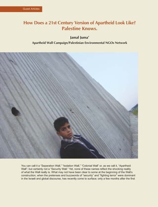
  • 1. How Does a 21st Century Version of Apartheid Look Like? Palestine Knows. Jamal Juma’ Apartheid Wall Campaign/Palestinian Environmental NGOs Network You can call it a “Separation Wall,” “Isolation Wall,” “Colonial Wall” or, as we call it, “Apartheid Wall”; but certainly not a “Security Wall.” Yet, none of these names reflect the shocking reality of what the Wall really is. What may not have been clear to some at the beginning of the Wall’s construction, when the pretenses and buzzwords of “security” and “fighting terror” were dominant in the Israeli and global discourse, has recently come to surface; only a few months after the first Guest Articles
  • 2. bulldozers began large-scale destruction of Palestinian lands, trees and property, the open public debate in Israel about how many settlements to annex with the Wall has turned commonplace. The Wall presents for us the future map of Palestine and the meaning of the kind of lifelessness that has befallen on Palestinians, on the little that will remain of their lands. All in all, we are witnessing a 21st century version of Apartheid, which will lay siege to Palestinians within fragmented, disconnected cantons, taking final possession of the Palestinian right to live in freedom, in a state like any other people. Work on the Wall’s “first phase” began in June 2002 in the northern West Bank, starting from the village of Salem, northwest of the city of Jenin, leading all the way to the village of ‘Azzun ‘Atma south of Qalqiliya, running the length of about 145 kilometers. In fact, the Wall is not being built on or even close to the Green Line, even in the case of Qalqiliya city, which is a town bordering the Green Line, the Wall is built over 150 meters inside the city, adjoining homes and shops, threatening them with demolition as they lie within the Wall’s 30-100 meter buffer zone. In other cases, such as in Jayyus, ‘Isla, ‘Azzun and Kafr Sur, the Wall is built between 4-6 kilometers inside the West Bank; this massive sweep is isolating approximately 11,500 people living in 16 villages between the Wall and the Green Line, disconnecting them from both the rest of the West Bank and from Israel. The Wall further isolates the lands from at least 50 additional villages which are located east of the Wall, while their lands are located west of the Wall. Alongside large scale confiscation and de facto annexation, thousands of dunums of agricultural lands and the uprooting of tens of thousands of trees have already taken place. More than 85 commercial stores have been demolished and more than double are awaiting the arrival of bulldozers, in most cases in order to further isolate West Bank communities near the Green Line into the non-livable, annexed zone. Hundreds of families have had their lands confiscated or their properties destroyed. Most of those who have lost land and property because of the Wall have been left with virtually nothing, awaiting monthly humanitarian assistance when they were, not so long ago, able to sustain themselves and at times flourish off of their lands and commerce. But, the “first phase” was nothing more than a “modest” beginning for what would soon follow. Amidst accelerated threats by the U.S. to attack Iraq in the beginning of 2003, further expansionist plans simultaneously began to appear, one after another, and in undoubted harmony between the settlers and their government. In January of this year, the maps that determined the Wall’s path to be the shocking length of 360 kilometers and that will isolate 95,000 Palestinian from the West Bank and the 200,000 residents of East Jerusalem from the West Bank would quickly fade. At the beginning of February 2003, the “Yesha” settler’s council/Israeli government announced its proposal to make modifications to the Wall’s path in order to annex additional, if not most of the settlement blocs, some of them, such as the Ariel settlement bloc, are 16 km inside the West Bank. This new plan, which the Israeli media announced was produced by the settlers in direct cooperation with the Israeli Ministry of Defense, isolates a total of 405,000 Palestinians and annexes to Israel 343,000 settlers, dividing the West Bank into two separate blocks north and south of the Jerusalem area. In March 2003, Sharon put his final touches on this colonial project, which began in 1967 if not in 1948, by announcing the building of a second wall in the eastern-central West Bank alongside the Jordan Valley; thus completing the confinement of an already shredded West Bank while annexing the settlements in the central West Bank. This plan of walls will divide the West Bank into three main disconnected residential ghettos; even within these areas communities will further be isolated from one another. These ghettos will be located at most locations kilometers inside the 1967 borders, as Israel chisels away into the West Bank from all directions. These ghettos are: The northern ghetto of Nablus, Jenin, Tulkarm; the central ghetto of Salfit and Ramallah; and the southern ghetto of Bethlehem and Hebron. Qalqiliya and Jericho will each be an open air prison surrounded by walls from all sides, as well as several other villages to the west of Ramallah and Salfit, here each group of neighboring villages will fenced in with a single gate leading to the closest larger ghetto. In total, the ghettos, between the two Walls, comprise 45% of the West Bank 139138
  • 3. upon which the Palestinian “state” will be established and where some form of connection lines, like fenced roads and concrete walls, may be provided between these ghettos. By tearing apart the West Bank in these disconnected areas, the Wall is reshaping the “final status” of the Palestinian state according to the Zionist project. Through the fortification of these walls Israel will “achieve” the following: •First, Israel lays hold over Palestinian lands while surrounding the residential areas in order to make them unlivable, controling the number of Palestinians able to survive, with the goal of ensuring for itself a Jewish majority in all of historic Palestine. •Second, Israel makes certain that no Palestinian state will be viable through the control of Palestinian water resources and fertile agricultural lands that could otherwise be the base for any future socio-economical and agricultural development. •Third, Israel effectively erases the 1967 boarders and redesigns them accordingly to meet their political ambitions of maintaining full control over the West Bank, as they consider it the land of “Greater Israel.” •Fourth, Israel completely isolates Jerusalem from the West Bank through the building of settlement blocs on all sides, strangling the city whereby no room for Palestinian expansion, demographically as well as socially and economically, remains. The Wall is the final step of Israel’s annexation of Jerusalem from the West Bank. To date, and including the Road Map, there has been no genuine interest by Israel and its partners in ending this colonial project of dispossession. The first commitment to putting an end to the colonial project, where the Wall represents the top of the colonial pyramid, is the dismantling of the Wall and the settlements. A Road Map that deals not with the fundamental, causal issues, negating the existence of the ’67 borders, relegating Jerusalem insignificant, denying the inalienable rights of the refugees, and allowing for the continued existence of the settlement project brings about a legitimate fear of the Palestinian people that such a document will blind the world into seeing the opposite of what really is. Taking into account the daily “developments” on the ground, marked by brutal violations and crimes, the Road Map could symbolize not only the Oslo whirlpool but a momentum that could lead to even further devastation. Therefore, the Wall should be defined as the last phase of the Zionist colonial project aimed at the complete control on the West Bank, which began immediately following the Occupation of the West Bank in 1967 and whose implementation has continued in a well- planned and organized manner, culminating with the building of a succession of Walls that will absolutely control the fate of the Palestinian communities. Guest Articles
  • 5. ISRAEL’S FINAL PUSH: THE FENCE MAP IS THE ROAD MAP Palestine Land Development Information System (PALDIS) With this report, the Ramallah-based Palestine Land Development Information System (PALDIS) summarizes the initial findings of its ongoing research into the effects and impacts of Israel’s Separation Fence being constructed on the West Bank. Introduction Was it shock that went through the Occupied Palestinian Territories when people saw headlines in their daily newspapers translated from the Hebrew press, which read: “The New Sharon: Israel Cannot Keep 3-5 Million Palestinians under Occupation Forever”, referring to how the Israeli prime minister addressed the Knesset at the end of May 2003? The question that was raised was whether even a settler-champion like Sharon had come to his senses, and from the perspective of Israeli interests, the answer is yes. But, the skepticism and wariness among Palestinians towards what was presented in the Israeli and western media as groundbreaking is the most indicative of how the real intentions behind this “shift” in Israeli government’s policy should be understood. Sharon, along with an influential echelon of the Israeli settler movement and high ranking army officers, together agree that, from their perspective, the time for “change” has come. Therefore, when the Israeli prime minister publicly admitted in May 2003 that the Israeli Occupation inflicts a terrible cost on both nations and should be terminated for a two-state solution, his turnabout should have been less of a surprise. Already half a year earlier at the Herzliya Security Conference he had endorsed the US/Bush vision for a “Palestinian state”, to be established in cooperation with a “reformed Palestinian leadership.” This vision, which will be explained in this article, has now materialized into a political document, referred to as the Road Map, which was issued by the so-called Quartet (the USA, Europe, Russia and the UN) in the spring of 2003. In rhetoric, the document is presented as charting the course of steps to be taken by Israel and the Palestinians in order to establish an independent and viable Palestinian state alongside Israel in what it highlights as the shortest imaginable time frame. This objective needs to be thoroughly examined. At the Herzliya Conference the Israeli prime minister detailed the extent to which he endorses a Palestinian state: “A Palestinian state,” he said, “with borders yet to be finalized, which will overlap with territories A and B, except for essential security-zones…”1 The whole sentence is most telling and worth rereading as it sums up the essential elements of Israel’s current and probably final policy towards the Palestinians. Agreeing to a Palestinian state covering at least 42% of the West Bank undoubtedly marks the end of Israel’s expansionist drive within that 42%, but not beyond it, leaving the majority of the West Bank for Israel to expand in. Recent satellite images reveal at least 60 locations where intensive expansion of settlements is taking place, three quarters of which is around Jerusalem and the other around the settlement of Ariel, all areas that will not be included in the 42%. The importance of this policy cannot be overstated, not least to the extent in which it is not incompatible with the Road Map’s objectives. Amidst the political language of the Road Map, Palestinians are facing another, much more evident—perhaps more real--document charting their future. The first appearance of this “other” map occurred when a number of towns and villages in the northern West Bank were issued with section sheets of a as-of-yet not public, but completed document known as the Fence Map, under the common title in Hebrew of Tikkun Gvulot, literally meaning “Correction of Borders.” It projects a trajectory for the Separation Fence now being constructed by Israel in the West Bank. The Guest Articles
  • 6. document on the whole remains closed to the public eye. Parts of it are only released piecemeal to affected communities, usually just before the bulldozers are gearing up to clear a next section of land. Thus far only some 20% of the Fence Map has been disclosed, specifically for the sections of the Fence that will be completed by the summer of 2003. It reveals that the Fence incorporates whole Palestinian villages, or separates them from their land resources and has enclosed one of the major Palestinian cities within a wall, leaving only one gated outlet. Palestinians are alarmed by what it portends. How much land, how much income is going to be at risk? What is the relationship between the Fence Map and the Road Map? Officially—as presented to the public--the two documents are unrelated. In reality, the connection could not be stronger. In targeting the idea of a Palestinian “state” without pinpointing its territorial extent on the ground, the Road Map is focused on procedures, and therefore allows Israel to determine the content. The Fence Map, strategically, is the exact opposite: it negates in rhetoric any relationship to a state and its boundaries, and does not deal with arrangements between parties. What it does do is implant a physical separation between all of what Israel is determined to hold on to, and what then is factually left to the Palestinians. If the Road Map can be compared to how Palestinian statehood is being packaged, then the Fence Map stands for its immediate territorial substance. The allegory can also be taken in how the package is offered: until today the contents remains hidden from view. This article argues that a new consensus is emerging in Israeli mainstream politics, which is today lead by Israeli prime minister Sharon, about the need and advantage to leave the Palestinians with an independent “state” behind a solid line of separation in an area that has maximum contiguity within the 54% of the West Bank. It is directly correlated to the change in policy along with the extent to which Israel can now move unilaterally to make such plans happen. The so-called “painful concessions” the Israeli prime minister claims to be ready for, suggest a quantitative scope which has no basis in reality, and which literally translates into minimal proportions of a handful of tiny settlements, representing only 2% of the total settler-population and a number of mostly uninhabited “outpost” sites. Therefore, the advantages of such a policy, for Israeli expansionism, are extreme. This article concentrates on what the Israeli government is now preparing on the ground and what is to be established amidst this new unilateral drive for separation, the contours of which take on the physical shape of concrete and electronic wire of Israel’s Separation Fence. While more than three-quarters of its trajectory is still kept secret, the workings of the Israeli political system made the release of hard statistics on the planned Fence sporadically imperative, without having to provide the entire map or the full picture. Such information, in combination with site descriptions by the Israeli army, enables to make a reliable projection of the recommended fence trajectory, in complete accordance with all the data and information on the Fence that were made available to the Israeli public. The first map with this article traces the course of the projected Fence throughout the West Bank according to its designated sections, and evaluates the total territorial scope of its impacts. It shows a configuration of severely fragmented Palestinian cantons which are completely encapsulated by Israel on some one-half of the West Bank. Map 2 presents an initial, comprehensive overview of all the Palestinian villages and cities which on account of the projected Fence according to the recommendations of the Israeli army will be severely affected. The presented statistical summary of these local impacts taken together is utterly disturbing in light of the Road Map’s alleged objective of a viable Palestinian state. They highlight that more than one third (39%) of all Palestinian localities will be adversely affected by the Fence , over 13% of which will end up at the “Israeli controlled side” of the Fence , which totals almost 16% of the West Bank’s Palestinian population, to a large degree on account of East Jerusalem and its surroundings. The instantly recognizable impacts for the other 26% of the affected localities are related to land cultivation and water resources isolated or destroyed by the Fence. 143142
  • 7. Map 1 summarizes the loss of territorial cohesion of the Palestinian districts on account of the Fence. It shows that of the 11 districts only 4 will be left with some substantial cohesion, 5 will be utterly fragmented, 2 will be compacted to respectively one fifth and less than one-tenth of their areas, while the core district of Jerusalem will be lost altogether. The Return of the Allon Plan Readers familiar with the twists and turns of Israeli policy towards the Palestinians over the decades will recognize that Sharon’s speech at the Herzliya Conference signifies a return to the so-called Allon Plan, suggested immediately after the 1967 War. The original Allon Plan proposed to return the West Bank’s densely populated Palestinian areas to Arab (Jordanian) sovereignty, but hold on to areas considered essential for Israel, such as Jerusalem and the Jordan Valley, comprising roughly half of the Occupied West Bank. The Plan was largely motivated by the drive to preserve Israel’s character as a Jewish state, which would be at risk if the densely populated Palestinian areas would be incorporated. The plan got nowhere, in the first place for lack of an Arab partner willing to go along with it, but also because extremist Israeli settlers had other aims. They chose to ignore the demographic concerns that prompted the Allon Plan and began to settle the West Bank’s densely populated interior, in order to lay the foundations for “Greater Israel.” They always had Ariel Sharon squarely on their side who, particularly in the capacity of Israeli cabinet-minister, was doing all he could to facilitate the endeavor. Not long ago, he encouraged a new generation of settlers to expand their views and “grab the hilltops”, resulting in a profusion of so-called “outposts”. Sharon’s Herzliya speech, grudgingly absorbed by most of the rank and file of the Likud party, signifies a major shift in the geopolitical strategy of the Israeli settler movement’s principal political bulwark. Today, the Israeli prime minister keeps on signaling that outposts, even settlements, have to be given up. At the recent Likud convention in Jerusalem, Sharon compared it with Israel needing dental surgery, “Yes, he said…I’ll pull out some teeth. I’ll feel the pain as well, but I’ll pull the teeth anyhow...”2 Most of his party members understood that the surgeon did not mean to leave Israel toothless. On the contrary, there are indications that a majority of the Israeli settlers have begun to understand the necessity and wisdom of removing elements that are untenable for the sake of securing all the rest. Anxious settlers wonder how much that is and what will determine its quantity. Earlier, in addressing the Knesset, Sharon had reasoned that Israel cannot continue its occupation of 3.5 million Palestinians. Being rebuked for using the term “Occupation” prompted Sharon, afterwards, to explain that he had used it only in relation to demographics. Reference to the Palestinian population as a constraint for settling the land was something Israelis were used to hearing from politicians on the Left, not from the Right. Meanwhile, Sharon did not elaborate his concerns in greater detail other than what he had stated in order to keep his coalition with the ultra- nationalist parties up and running. A “State” behind a Fence One of Sharon’s prominent advisors, Dr. Arnon Soffer of Haifa University’s Center for National Security Studies has already, for years, been outspoken on the subject of “demographics” and may have influenced Sharon’s turnabout. Soffer states that in less than a decade there will be a Palestinian majority population in all of the country (historic Palestine), including the Palestinian Territories, brought about by the high Palestinian birthrate. His concerns are not unlike what prompted the original Allon Plan. But the urge to address them, now, is much greater. Simultaneously, reports in the Israeli media are talking about a demographic “tide” of Palestinians threatening to “inundate” Israel.3 Based on his belief in never arriving at a lasting territorial agreement with the Palestinians, Dr. Soffer concluded a couple of years ago: “The only possibility is absolute separation from the Guest Articles
  • 8. Palestinian Authority...a border system should be erected between Israel and the Palestinian Authority, constructed of electrified walls and fences…it must enable, through corridors, the territorial contiguity of the three parts of the Palestinian Authority…” (the cantons of Nablus, Hebron and Gaza).4 Soffer proposed a border to enclose Palestinian areas according to a broad Zionist consensus shared by the Likud Party, the erstwhile Third Way Party and the Labor Party. What are the basic foundations of that consensus? In 1995 a new Israeli party was founded called the Third Way, aiming to offer a “centrist” political alternative in between Labor and Likud. This party –which did not last long in Israel’s political history- advanced a final status option for the Palestinian territories that was coined as more “accommodating” to the Palestinians than the option favored by the Likud, which was known as the Allon Plus Plan. The Third Way Plan (of 1995) explained that “it is intended to provide for Israel’s security and developmental needs”. It would entail the incorporation of 93% of the West Bank’s Jewish settlers (East Jerusalem not included), while at the same time leaving a similar percentage of Palestinians within autonomous areas that “can not endanger Israel strategically…Greater Jerusalem, the Jordan Valley and strategic areas on the mountain ridge, including control of the water sources, are not to be compromised…” A special paragraph emphasized the need “to ensure contiguity between the various parts of the Palestinian territories and the neighboring Arab States.” Over the years the need for a “Palestinian state” from an Israeli point of view has become a centerpiece of this consensus. It is partly borne by a logic in which such a state provides a basic foundation, administratively and economically, to absorb the Palestinian demographic increase— i.e. Palestinian population in general--away from areas settled by Israel and towards the areas overlapping with Oslo Territories A and B, which in turn requires a basic measure of contiguity. For another part, this logic relates to the need to relieve Israel of the “burden” of occupation along with the international laws that it, as the occupier, must abide by. Ultimately, what is highlighted is the fundamental clash between Palestinian struggle—and right—to self-determination and the end of the Occupation, expressed in the establishment of a Palestinian state, and the expansionist policy of Israel that inherently denies this right. This highlights the kind of state that Israel looks to impose on Palestinians. A Palestinian state is risky for Israel on the long term if its borderlines would be left unresolved and undemarcated, considering the legitimate claims of a Palestinian state on occupied territories that Israel does not intend to give up, such as East Jerusalem and the major settlement blocs. It is an additional consideration to the demographic imperative that prompted Soffer to call for an immediate, unilateral separation in the form of a so-called “security fence”. Ariel Sharon has succeeded in maneuvering the Likud closer towards the “center” position of the broad consensus of the Israeli political mainstream, and get his party and coalition partners to adopt the idea of unilateral separation behind a Fence . Supported and demanded by the Israeli public, the Fence takes a course which is not primarily determined by considerations of security, but by the geopolitical drive to secure territory. Sharon’s greatest achievement is probably how he managed to convince his governing coalition, which includes ultra-nationalist settler parties, to line up with the Quartet Road Map, as the internationally endorsed charted course toward a two-state solution, which in its wording is nowhere incompatible with Israel’s objectives. While this is an achievement, it should also signal that the Road Map and Israel’s plans in relation to it may have required little convincing for his coalition. Despite what some people would like to read in the Road Map, it has nothing to do with the territorial dimensions of the two states. In Sharon’s view this is taken care of by the Fence Map. 145144
  • 9. The Fence Map Map 1 shows the Fence according to the sections currently being constructed and planned by the Israeli army. Apart from the first sections, most of it (80%) exists only in the form of a blueprint which is kept as top secret. For Palestinians, it is critical to understand its full territorial scope in order to assess how it will affect the prospects of a viable Palestinian state. That is why the PALDIS Project has undertaken to make a projection based on the data and descriptions that were released by the Israeli army. Combining very precisely stated Fence lengths for separate sections and on the whole, with a list of settlements which are likely to be evacuated and the consideration of terrain features that conform to the pattern set by the already completed sections of the Fence, makes it possible to narrow down a number of trajectories to one which is the most likely, and which completely matches the Fence statistics released by Israel. Some relatively minor uncertainties with this projection cannot be resolved as of yet; these are specified separately and indicated on the map legend. The map also depicts alternative fence trajectories demanded by Israeli local and general settler councils, such as the Yesha settlers council, in order to incorporate the settlement blocs of Elon Moreh, Itamar, Shilo, Talmon, Tekoa and Othniel. Fence Sections A and B The first section of the Fence, designated with the capital letter A (in Hebrew also indicating a numbered sequence) begins next to the Palestinian village of Salim (in Israel, next to the West Bank’s northern tip) and goes down south until the settlement of Elkana, near the Palestinian city of Qalqilya. Part of Fence Section A also covers Jerusalem, which will be discussed later in the article. The trajectory for Section A was released by the Israeli Army Directorate on a map late in autumn of 2002. It showed that the West Bank would be stripped of Palestinian land east of the Green Line, some 3 to 5 km deep, including within it some Israeli settlements and a number of Palestinian localities. If this would set a pattern, was the conclusion drawn by some analysts, then more than 95% of the West Bank would remain intact. For those same people, bad as it was for the directly affected local Palestinians as well as for the Palestinian’s legitimate claim to all the 1967 Occupied Territories, it gave room for seeing the Fence in collateral beneficial terms, because according to that viewpoint the Fence demarcated Palestinian area east of it that would be bound to become the future Palestinian state. This viewpoint was further strengthened when the Israeli army released data on Fence Section B going from Salim towards the Jordan Valley, which seemed to indicate that it would almost precisely follow the Green Line. There were those Palestinians, a small number indeed, which felt they had nothing to worry about; of course this voice did not include the affected Palestinian local farming communities, many of them seeing more than half of their fields disappear behind the Fence. Once the Road Map was endorsed by the Palestinian Authority, the Israeli army released information on the Fence’s next Section C. Fence Section C With this section, the Israeli army recommended drastic changes compared to the initial plan. The changes are threefold. First, the Fence is no longer to proceed relatively close along the Green Line towards Jerusalem. Instead, it will be biting deep into the West Bank, along two finger-shaped indents: one at the head of Kedumim settlement, the other at Ariel settlement. Then it goes back to about 5 km east of the Green Line, before going down towards the current Qalandiya checkpoint, immediately south of Ramallah. It is unclear whether the Israeli army recommended including another deep indent, meant to incorporate the Talmonim settlement bloc, west of Ramallah. No final decision has yet been taken. There is a second, distinct difference compared with the Fence’s initial section. The closer it Guest Articles
  • 10. comes to Jerusalem, the deeper the Fence is within the West Bank from the Green Line. While the Fence leaves most of the northern Palestinian governorate of Jenin intact, that of Ramallah will be reduced to half its size and compacted into an indented “box” of only 25 by 25 kilometers. This brings us to the third major difference with the Fence’s first section. The drastic amputation will be leaving a substantial number of Palestinian villages out of that “box”, ending up not within, but behind the Fence. That is why the Israeli army intends to group those villages together in clusters, turn them into fenced “enclaves”, and give them access to the larger Palestinian cantons behind the Fence through a minimum number of “access” roads. Examples of such enclaves are the clusters of villages around Beit Liqya and around Biddu in between the Latrun salient and Jerusalem. Incorporating them within the main Fence would bring Highway 45 from Tel Aviv to Jerusalem through the West Bank into the Palestinian canton of Ramallah. Israel wants to exclude that at all cost, since it considers Highway 45 as an indispensable, strategic asset. This is for several reasons: first, to fortify its hold on “Greater Jerusalem”. Second, because it gives direct access to the Jordan Valley, as a key strategic area for Israel. It is difficult to project the degree to which the enclaves will be tightly constricted by barriers around them; but, according to the logic that calls them into being, it will be much tighter than the larger cantons themselves. Jerusalem Fence Section C is followed by Section D. According to the information released by the Israeli army, it will go from Bethlehem to Hebron. But where is Jerusalem in this sequence? As noted earlier, this part was brought under the heading of Fence Section A, with a stated length of 22 km. This is a remarkable number, given the fact that the municipal boundary for East Jerusalem, just on the east and south side, is almost twice as long. Why then is the Fence for Jerusalem so short? One explanation is that the city will most probably hardly be fenced-in. Only short sections are needed to keep Jerusalem clear of Ramallah in the north and Bethlehem to the south. According to this objective, no fence is needed either west or east of the city (except opposite Abu Dis). On the contrary, Israel aims to maintain a wide, open connection between the city and settlement “suburbs” in the city’s outskirts, such as Ma’ale Adumim and Giv’at Ze’ev. In this way, much more than just the city becomes incorporated. This can occur not by fencing Jerusalem in, but by fencing in the near-by cities of Ramallah and Bethlehem to the tightest possible parameters. It effectively means that Israeli “Greater Jerusalem”, by swallowing over 90% (!) of the whole Palestinian district named after the city, will be transformed into the shape of a huge territorial wedge, which will tear the West Bank apart into two separate pieces, one in the north and one in the south, while emptying it of its Arab metropolitan core. These effects by themselves can already be considered fatal for the objective of a viable independent Palestinian state. There is nevertheless evidence that within the “wedge” of Israeli “Greater Jerusalem” subsidiary fences, most likely walls of the type constructed around Qalqilya, will be constructed. The map shows Palestinian inhabited East Jerusalem in light yellow stretched-in between Ramallah and Bethlehem. Unofficial information suggests that sizeable Palestinian suburbs such as A-Ram may be enclosed by walls and fences. Bethlehem and Hebron Fence Section D is planned for the Palestinian districts of Bethlehem and Hebron. Its pattern is familiar. When the Fence is going to tear the Ramallah district into shreds, then what it will leave for Bethlehem is simpler in shape, but equally devastating. Not including the expanse of largely uninhabited desert towards the Dead Sea, renders the district to its compact core of towns, villages, fields and orchards to some 20 by 15 kilometers. The Fence will simply cut it in two, one piece west of the highway to Hebron, the other east of it. The western half will fall at the so-called Etzion bloc of Israeli settlements, with some 20,000 settlers; the eastern half will be left to the 147146
  • 11. governorate’s Palestinian inhabitants, with a seven times greater population than the settlers in the Etzion half. But, in terms of land productivity, the Palestinian side will be left with far less than half. This is due to the higher amounts of rainfall on the western hill slopes which will leave the most productive lands at the Etzion side of the Fence. In terms of disrupted road communications, the district of Bethlehem shares a distinct record with that of Ramallah and Jerusalem. The main Palestinian trunkroad through the West Bank’s core Palestinian districts will be completely left out at the other side of the Fence from just above Hebron at least until Silwad and most probably to just below Nablus. The west side of Fence Section D around Hebron is similar to Section A in the northern West Bank. It stays relatively close to the Green Line, and is likely to make indents around the tiny settlements of Adora and Telem and around Eshkolot. But the south side of Section D has more in common with Section C around Ramallah. Also in this case a much wider strip of Green Line borderland is recommended to be taken in and included in the Israeli controlled side and most probably also an indent with the same depth as that of Ariel in the north. This one connects to the Israeli settlements of Hebron city, centered at Qiryat Arba. Together with the one coming from the settlement of Adora, it clenches the city of Hebron in between them and causes the district to gravitate into four different quarters. The Jordan Valley When the Israeli army announced its recommendation for the Fence to go all the way around Ariel to the east, it rounded matters off with an even more drastic suggestion. The following sobering conclusion came from Israel: a Fence alongside Israel in the west would leave the east wide open. That is why the Israeli army proposed a last piece to close the system. It recommends a Fence all along the so-called Allon Road, trailing the West Bank’s eastern foothills next to the Jordan Valley down towards the south. Near Jerusalem the road crosses the highway to Jericho at Mishor Adumim settlement from where it continues further down until it reaches the Hebron hills. The intention to keep all of Israeli “Greater Jerusalem” open from west to east will split the Jordan Valley Fence section into two separate parts. One sub-section from the north that will be tied up to the endpoint of Section C in Ramallah, the other from Bethlehem that will be tied up to the endpoint of Section D south of Hebron. The resulting effects are obvious. If the Israeli “Greater Jerusalem” “wedge” will be tearing the West Bank into two separate pieces, than the incorporation of the Jordan Valley within the “Israeli controlled side” of the Fence will add another effect: it will additionally isolate those pieces from the West Bank’s Arab hinterland. The Israeli army provided scant details on the recommended fence trajectory for the Jordan Valley. The intention to secure the Allon Road made clear that the Fence is meant to include the strategic heights west of it. These heights are commanded by settlements like Elon Moreh, Shilo, Bet El and Ofra. Even if the Fence would run along a more or less straight line along the hillcrest west of the Allon Road it can be easily hooked up to the internal fences around those settlements. Press reports have mentioned that the eastern Fence will also leave two Palestinian enclaves in front of it, “...which may come under Palestinian rule in the future…”5 Likely candidates for the two enclaves are the current Oslo B Areas of Taybe and Deir Dibwan, to the northeast of Ramallah. Both are squeezed in between the settlements of Shilo and Bet El, which are linked together by a crucial section of the main Palestinian trunkroad (Highway 60), which was rerouted by Israel to bring it closer to those settlements. Keeping the two Oslo B Areas as enclaves in front of the fenced Ramallah canton will also leave the rerouted road link between those settlements in front of the Fence on the Israeli controlled side. This territorial reshuffle has grave consequences for the fenced-in Palestinian area. As related above, it will take the West Bank’s vital trunk road completely out of the core Palestinian districts from just above Hebron until just below Nablus. Palestinian traffic between north and south will then be relegated to secondary rural roads, doubling or tripling travel time and travel costs. Guest Articles
  • 13. Another consequence of the fence trajectory for the Jordan Valley merits attention. It is how the settlement-indent of Shilo, halfway between Ramallah and Nablus, if included will reach out towards that of Ariel, leaving just a narrow gap where the Palestinian districts of Ramallah and Nablus connect to one another. Joining the two settlement-indents without disrupting Palestinian contiguity between the districts of Ramallah and Nablus requires just a bridge or tunnel passing over, or underneath the other side’s road link. In other words: contiguity for one side can be made compatible with that for the other side, but not necessarily on equally advantageous terms. The measure of contiguity which will be afforded to the fenced-in Palestinian areas is comparable to that within an extended ghetto, or in the Palestinian case, to that within a string of four such ghettos, only two of them bridged together (Nablus and Ramallah). However, in principle, any number of additional corridor-passages could be created, for instance through Jerusalem, or between the cantons of Gaza and Hebron in order to attain full, instead of maximum contiguity. The real scope of allowed Palestinian contiguity will be discussed further below. Cantonization At this point it is useful to take a first, complete look at what the Fence is going to bring about when it will be constructed according to the Israeli army’s recommendations. The first striking effect is the total encapsulation of the Palestinian West Bank into three “cantons” (a designation that has now become part of the Israeli geopolitical vocabulary) of which only two are barely connected (Nablus and Ramallah). All three Palestinian cantons are tightly squeezed within belts of Israeli settlements. The West Bank on the whole, already cut off from the Gaza Strip, is disconnected from its Arab hinterland east of the Jordan River. Secondly, Israeli “Greater Jerusalem” will be cutting the West Bank in two parts, while the contiguity that remains where the West Bank’s Ramallah and Nablus districts connect, above Jerusalem, will be reduced to just one single road-width in between the indents of Ariel and Shilo. In contrast, the area ending up at the western or “Israeli controlled side” of the Fence will acquire all the cohesion and contiguity that is degraded or lost on the other side. All settlements within that area will be hooked up to a square grid of fast driving freeways with Highway 45 as the backbone of the nascent Israeli metropolis made up of “Greater Tel Aviv” and “Greater Jerusalem” situated in the country’s core. Places like Ariel, Shilo, Bet El or Efrata, for decades regarded in Israel as nothing but backyard peripheries, are likely to see a spectacular rise in socio-economic status when the Fence will be completed. The Fence will be instrumental in enhancing their absorption in the country’s core as metropolitan suburbs situated at highly attractive locations. Contiguity The Quartet-Road Map targets the creation of an independent Palestinian state with provisional borders through a process of Israeli-Palestinian engagement, part of which is to “enhance maximum territorial contig(n)uity”. Would this not at least require a restoration of the contiguity that was broken up on the Palestinian side? Not according to how that objective is worded in the Road Map. The words “enhance” and “maximum” fall short of restoring the full territorial contiguity which the Palestinians had even before Oslo; the extent to which it is to be restored, reading from the Road Map, apparently depends on what is standing in the way of that objective, which is the contiguity taken by Israel from the Palestinians and self-apportioned by the settlement-domain of Area C. If so, then the Road Map implicitly requires the Palestinians to reconcile their need for contiguity with what Israel claims for itself. Palestinian geographic contiguity is one of the few vital concerns that have entered the vocabulary of the Quartet Road Map. The reason why it became such a recognized concern is obvious. Thanks to the Oslo Process the West Bank got administratively dissolved into separated Guest Articles
  • 14. Palestinian fragments. When Israel began to construct a network of so-called “bypass” roads linking the settlements around the Palestinian fragments, the administrative fragmentation turned into something tangible on the ground, with the result that the original Palestinian contiguity of the West Bank got superseded by that of the bypass-linked domain of Israeli settlements, known as Oslo Area C. The closure imposed by Israel upon Palestinian towns and villages has more than crystallized that situation. It has compelled Palestinians to fall back on rural tracks and field roads in order to maintain a minimum of road-contiguity, which however exacts a heavy price in transportation costs. Israeli geopoliticians have come up with various suggestions on how to achieve Palestinian contiguity. A formula of bridges and tunnels to link discontinuous areas for achieving “maximum” contiguity features prominently in those suggestions. There is ample evidence to suggest that this formula will be instrumental in compelling Palestinians to enjoy “maximum” contiguity embedded in the framework of cantonized fragmentation. The examples of the Palestinian districts of Qalqilya and neighboring Salfit are instructive. Originally these governorates lacked nothing in contiguity. ( see map on page …) Each depended on a main road from the west to the east, linking up at Nablus to the central Palestinian trunk road, which connects to Jenin up north and to Jerusalem and Hebron down south. Two side roads linked the districts from north to south and vice versa. Initially the construction of Israeli settlements along those roads did not obstruct Palestinian contiguity, nor the administrative division in Oslo Areas A, B and C. But it prompted the construction of “bypass” roads on an unprecedented scale. The term itself is often wrongly understood. In most cases bypasses were just built around short road sections going through Palestinian villages. It effectively changed the originally Palestinian main roads into primarily settlement-linking highways. This happened first when Highway 5, the transportation “backbone” of the Salfit governorate, was rerouted to the settlement of Ariel. From there, its new trajectory is no longer primarily heading for Nablus, but for the Shilo settlement bloc. This will also happen with the other main road from Qalqilya to Nablus. A new “bypass” is announced to go around Qalqilya and Azzun, before linking up again to the traditional main road. From there, it will however no longer be leading to Nablus, but to the settlement bloc of Shomron, where it terminates at Qedumim. Since the Intifada closures, the new Israeli bypass link-ups have turned into cut-off’s for Palestinians. It means that the Qalqilya and Salfit districts are now effectively deprived of their main transportation arteries or, in other words, their most effective contiguity. It requires Palestinian citizens to follow tortuous routes over rural tracks and secondary roads taking hours rather than minutes to reach a destination that is often within eyesight. For example: the usual 10 km trip from the village of Bidya to the city of Salfit now necessitates a journey of 80 km, and a passage through two other districts. The map shows a number of existing or anticipated under and overpasses to leave the Palestinians with a bottom substance of road contiguity while Israel keeps the optimum contiguity imposed since the Oslo Process. Land for Settlement Expansion The settlement-indents reveal a distinct characteristic, which already became apparent with the first section of the Fence. Incorporating a small settlement, for instance that of Zufin, near Qalqilya, makes the Fence usually swallow land five to ten times the size of such a settlement. It is difficult to explain that amount in terms of enhanced security. A closer study of the planning schemes for the settlements in question like Zufin, reveals that the amount is usually meant to secure their intended future expansion. That future is claimed at the expense of Palestinian farming communities, which entirely depend on those lands for their livelihood. In other places, the Fence will incorporate Palestinian village land for settlements that do not as of yet exist or have just been established, as with the Palestinian village of Kufr ad Dik, north of Ramallah. First, Kufr ad Dik lost one third of its land to the settlement of Aley Zahav. Now, the 151150
  • 15. Fence will take another third for a new settlement, with the name of Brukhim of which the first apartment blocks are already going up. These buildings are being integrated within the surrounding lands of Kufr ad Dik’s age-old olive trees, which in the future will be “neatly” enclosed within the Fence on the Israeli controlled side. It is beyond the scope of this article to provide a detailed list of similar cases. The map depicts all major areas of proposed and projected Israeli settlement expansion. Satellite imagery reveals that today there are more than 60 sites of intensive Israeli construction in those depicted areas. Fence planners of the Israeli army keep on insisting that the Fence will not jeopardize the livelihood of the local Palestinian population. Under the name “Fabric of Life” the Israeli army has a policy that aims to permit access to local farmers whose lands are west of the Fence, by installing a number of agricultural gates. When the Israeli army extols the virtues of the “Fabric of Life” it only refers to permitting passage back and forth. However the fact that lands behind the Fence are getting lost for developmental purposes, like new housing, infrastructure, workshops, or upgrading of greenhouse cultivation is completely ignored in the “Fabric of Life” philosophy. In addition, as of yet there are no signs that such access will in fact be made available, while farmers have already been unable to access their lands. Conclusion: The Final Push Summarizing all Palestinian localities that will be adversely affected by the Fence surfaces the implications of the Fence on Palestinians and a viable Palestinian state. The numbers, presented in a comprehensive, graphic overview, are staggering and highlight the magnitude and scope of the Fence, along with the maps that simultaneously illustrate the finality—the sealing of the fate— of the prospects of a viable two-state solution and an end to the Occupation. Reviewing Map 2 is essential for the article’s conclusion. Affected localities are being defined according to two basic criteria: one is the exclusion of localities from Palestinian areas that are fenced-in, i.e. Palestinian localities within the “Israeli controlled area.” The other is the separation of localities from their land and water resources by the Fence. Map 2 depicts these categories of affected Palestinian localities in two different color-shadings and summarizes their percentages in proportion to their total number and the total population on the West Bank in the pie charts to left. The red-colored circle-symbols represent the Palestinian localities which will end up at the “Israeli controlled side” of the Fence. Concentrations of such localities can be found around Jerusalem, in the Jordan Valley region, south of Hebron and in the West Bank’s northwestern part. Altogether, they comprise 13.5 % of the West Bank’s Palestinian localities and more than 15% of its population. Two-thirds of this number is made up of Jerusalem’s Palestinian citizens, represented by the Old City symbol on the map. It is important to put these numbers in perspective. Palestinian East Jerusalem and its immediate suburbs which are kept out of the fenced Palestinian areas are inhabited by more than 300.000 people. In proportion to the West Bank’s major cities it means that 40% (!) of the West Bank’s urban population will be excluded from the Palestinian core domains. The other category of Palestinian localities adversely affected by the Fence is those localities which are separated from their land and water resources, represented by yellow-colored circle- symbols. These can be found along the trajectory of the Fence all over the West Bank and within the so-called “enclaves”. The map’s small scale does not allow for depicting the degree to which these localities will be adversely affected by the Fence, it just reveals the quantitative scope of impacted localities and the pattern of occurrence. It reveals that altogether at least one quarter of all Palestinian localities are in this category, comprising close to 19% of the West Bank’s Palestinian population. The map also shows white circle symbols which represent the same category of affected villages if the nearby settlement-indents would be hooked-up to the Fence. Guest Articles
  • 16. The pie charts to the left of Map 2 summarize these percentages in a one-glance proportional view. It first shows that the area left to the Palestinians within the Fence will be no more than 54 % of the West Bank, with an additional 2% when including the “enclaves”. The chart also shows that when the indicated settlement-indents, such as Shilo and Talmon, would be connected to the Fence the 56-54% would have to be lowered to 52.5 -50.5%. The two smaller charts at left depict the proportions of the affected Palestinian localities and their inhabitants in relation to all of the West Bank’s Palestinian population and localities. Altogether these proportions mark a staggering and undoubtedly fatal depletion of the needed capacity for the targeted Palestinian state to become economically, or otherwise, viable. Accepting the rhetoric behind “viability”, “contiguity”, and “state” while discarding them of their actual meaning, opens the door for Israel to implement its strategic plans in the West Bank, exemplified by the facts of the ground created by the Fence Map and the Road Map. Cantons and enclaves, fenced in communities, the negation of the ’67 borders, Jerusalem, and the Right of Return all seal the fate of the Occupied Territories and ensures that no real viable state will ever come into existence. Endnotes 1 Herzliya Speech, www.herzliyaconference.org. 2 Ha’aretz, May 26, 2003. 3 Yedioth Ahronoth, May 23, 2003. 4 Soffer, Arnon, “Israel, Demography 2000-2020: Dangers and Opportunities,” Haifa, 2001. 5 Ha’aretz, March 23, 2003. Implementation of the Road Map “Separation Wall” 153152
  • 18. The Apartheid Wall: Living through the Reality Abdul-latif Khaled Apartheid Wall Campaign Emergency Center, Qalqiliya District Palestinian Hydrology Group The colonial approach prevailing over the current political and economic state overwhelming the area is beginning to show its true face. The current period passing the region is the “bottleneck” stage, seen by Israel as the prime time, from both the political and security standpoints, to (re)activate its most dangerous historic plans. The aims of the Wall project have been formulated within a framework that allows for their implementation under the pretext of “security,” all the while Israel is not compelled to abide by signed international agreements and conventions. This new-old issue, which has as its origins the settlement expansion plan, aims at seizing land and displacing residents; thus turning their struggle into yet another chapter awaiting “negotiations”. The Wall is none other than an imposed policy to force Palestinians into accepting the status quo and push them to “negotiate” what remains of their land. Unlike previous land confiscations, the Wall calls for the unprecedented—in both quality and quantity—land confiscation and/or isolation that will bring about massive annexation “into” the 1948 borders. In comparison to previous land confiscation orders for Israeli colonies after 1967, the seizure of this land differs in that now there is direct effort to permanently link colonies in the West 155154
  • 19. Bank with Israeli cities, effectively diminishing the Green Line. According to the Wall’s “first phase,” over 120,000 dunums of the most fertile and productive agricultural lands will be confiscated or isolated. More importantly, these areas are the highest water sensitive recharge areas and the most abundant in terms of water resources. This is clearly highlighted when viewing the Wall plan for the Jenin, Tulkarm and Qalqiliya districts. In addition, these plans have been continuously modified either prior to or during implementation, highlighting the following three main issues: First, although the Wall’s master plan is only a portion of the expansionist plan that exists, it is insufficient in answering to the needs of the Israeli extremist political parties. This becomes evident when mapping out the repeated modifications made to the plan along the Wall’s path. For example, while the first master plan retains the natural connection between Qalqiliya and its surroundings, modifications made to the plan ensure the community is sealed, paving the way for the annexation of settlements that extend east of Qalqiliya city and up to the borders of Nablus city. A by-pass road extending this length, and clearly indicated in the Israeli modification of the “original” plan, confirms the intention to annex land in accordance with other Israeli expansionist plans. Up until recently, the village of ‘Azzun ‘Atma had been completely included and annexed. Newer versions of the modified plan exclude the village inhabitants (built-up area) and their houses, while only annexing their lands! Second, the decision makers and planners of the Wall have the consistent upper hand and complete freedom to change and modify the plan. All modifications are based upon recommendations aimed at absorbing the most expansionist ideals. An example is the incorporation of the proposal presented by the settlement council aimed at thickening deeply rooted settlements in the West Bank. In addition, new segregation and more extreme plans have recently been brought to light, with the intention of dividing the West Bank into separated cantons, completely isolating Jerusalem in particular, annexing tens of settlements and confiscating hundreds of thousands of dunums. Third: Albeit the Wall plan and its destructive implementation which is bringing about a human catastrophe, the world, Palestinians, Arabs and internationals alike, stand horribly silent. The extent and gravity of the destruction that the Wall is causing to the land, and the Palestinian cause in general, is similar to and even worse than the catastrophe and defeat of 1967; especially since more than 65 localities are directly affected by the Wall during the “first phase.” It is important to understand that not a single location or human being in the West Bank will remain unaffected directly in the coming phases of Wall’s construction. The silence and vulnerability that has accompanied the construction of the Wall this past year has given the planner or decision maker the upper hand in altering, modifying, and implementing the plan inside the West Bank. On the one hand, Israel has been trying its best to implement the “first phase” of the plan without making public any new plans. On the other hand, Israel has been closely watching the various responses to its actions. The immense acceleration of enforcing and expanding the plan within the past three months, the disclosure of confiscation plans, and the isolation of up to 60% of the West Bank is living proof of the state of debility and weakness that is prevailing. Within this context, it is noteworthy to recount some of the modest experiences of defiance against the construction of the Separation Wall. Despite the modesty of these experiences, they are positive indicators for the need to work better in defying the implementation of this plan. The construction of the Separation Wall is ongoing, thus we must actively resist the Wall along every path. It is no secret that the Wall is becoming a tangible reality, with all of its technical aspects, that runs from Jenin Salfit districts. With the suffering and pain it carries in its folds, it embodies the reality represented by the simple peasants and farmers. With what accompanies building the Wall, including economic, hydrological, environmental and social destruction, we are more capable of feeling and seeing the effects of this Wall- closure, besiege and inconvenience in trying to reach the isolated lands behind the Wall. As we have always been used to following the incident without Guest Articles
  • 20. sharing in the decision making process, the Wall came as a surprise to all the damaged locations, unexpected to the nongovernmental organizations and the local bodies. The shock or surprise, each according to his location and responsibilities and perspective of the conflict, varied along the country side. But the reaction to the Wall didn’t come as it is supposed to be, especially from those who are capable of doing something or creating a reaction and a position. Starting with the simple peasant who woke up one day to find his land or property confiscated, isolated or destroyed is the most damaged. For him, the land is a source of income source and implies existence. Attempts to express the right and the refusal of the confiscation order through the legal channels available failed and his case was refuted. This peasant participated in refusing the confiscation order; he expressed this refusal by standing up to the bulldozers, but unfortunately he couldn’t prevent it for long from razing his land. He is now at a stage where he awaits and imagines how the next phase will be and he pins his hopes on the promises to set up gates that shall enable him to access his land. Very often this peasant denies himself the right of even thinking of his future and the future of his land. He either awaits the future with a tearful and angry heart, or he keeps his hands on his sides or opens them up in prayer for a better tomorrow towards the sky. He blames the time he’s living in which he tries to avoid and runs away from seeing the Wall on his land. As for the nongovernmental organizations and the local and public bodies, known for their multiplicity and vastness in the country, they went into labor with the birth of the Wall. From one aspect, they are shocked by everything they see and register about figures, statistics and details in regard to the extent of the destruction and damage that is caused by the Wall. From another aspect, they are shocked by the reality of their modest legal capabilities to confront the building of the Wall, or of their more modest budget in the face of the destruction that is befalling the hydraulic and agricultural sector in these locations. Not to mention the extent and multiplicity of the basic needs in these locations once guaranteed the continuity of life. Lately there were various serious and fruitful endeavors to cover some of these gaps. The environmental nongovernmental organizations represented by the network PENGON that launched a campaign to stop the Apartheid Wall with the effort of six of its member organizations headed by the Palestinian Hydrologic Group (PHG), the Palestinian Agricultural Relief Committees (PARC), the Union of Palestinian Medical Relief Committees (UPMRC), the Land Research Center (LRC), and the Applied Research Institute of Jerusalem (ARIJ), to support the citizens in their hardships or the farmer on his land. Emergency Centers were opened up with the aim of uniting and activating efforts through establishing the voluntary local committees, gathering information and documenting it by statistics, studies and maps. They also aim at activating the international and local public opinion; holding festivals, symposiums and journalistic meetings; and hosting many organizations, such as official as well as media delegations. Other aims include implementing various projects that serve the farmers’ sector or those affected by the building of the Wall. These aims were realized by joint efforts with the committees and the locations; good successes appeared, especially in the media field, for spreading the reality of the situation worldwide through the many delegations that visited the region. Also success for getting financial funds for some projects came from various foreign organizations during the most urgent time. Yet so far, nothing changed as a result of these efforts. The Wall is still standing in its place, the razing and destruction of the land is going on, and the destruction scenes are moving from one location to the other. Officially, in more than one meeting, nongovernmental organizations and the local and public bodies from one side, and members of the Palestinian Legislative Council (PLC) and representatives of departments and ministries from another side, the issue of the Wall was presented in two forms. First: its political and safety side where there was a complete refusal to the idea of taking part or even knowing of the Wall plans whether in the previous negotiating stages or in future proposals. The official position in regard to the Wall is the same as the public position that refuses the Wall plan with all its details, and that Israel is implementing it by the law of force and not of the law 157156
  • 21. or the security pretexts and that it defies all the legislations, covenants, agreements and understandings that were signed or that are being signed. Second: Discussing the Wall in its economical side and the official role in covering the Wall issue and its implications on the international and Palestinian levels. Internationally, there is a media and a public, and sometimes an institutional, concern that overtops the local one in the public mediums, and which greatly overtops the local media coverage provided by the Palestinian or the Arabic Broadcasts. Thousands of solidarity movements from different roots and origins, especially Europe and the United States, and even the peace movements inside Israel, supported the Palestinian people by standing with the residents in the field and sharing their hardship. The cities of Jenin, Tulkarm and Qalqiliya are never devoid of these solidarity delegations or of visits from the media and foreign official institutions. At this point, we have to stop in a moment of truth with ourselves, even to reprimand ourselves: Why activists from international solidarity groups arrive before us to our own lands? Why the foreign media and journalism arrive while our journalism and media are rarely there? This is not to say that our people or media were never present, but it was very much less than anticipated, which coincided with a state of silence from the personalities that we have become used to seeing and hearing comment and say their opinions on the simplest national issues! People who were affected by the Wall blame their representatives. Why is there this silence about the crime despite its atrocity? The land represents the soul of the issue and the core of the conflict; here we are witnessing the day of losing it with no comment! The Separation Wall is a national issue in such a way that all Palestinian sectors should interact amongst one another in order to counter the Wall. We are not accusing anyone person or institution for a lack of reaction, but at the same time we are not removing the responsibility from any parties. The experience of the last few months, or of the past year since the building of the Wall began, indicate that the extent of the calamity and its present and future implications have not been met with sufficient or equivalent efforts. This is especially true since the capabilities, whether Guest Articles
  • 23. public, media or international, are vast but have not yet been dealt with in the right way, or they have simply remained in place and most often withered and died without doing anything. These capabilities should be activated for the simple reason that they exist, and working on the Wall continues with plans in the horizon that are more tragic and comprehensive than the previous ones. Working against the Wall can be broken down to the following: •Increasing public awareness in relation to the extent and gravity of the Wall plan and supporting the public in realizing and feeling the impact of the Wall on his future in this land. This is especially because both experience and history highlight the fact that the Wall will reach the depths of the West Bank lands without sparing any village or town from its destructive wrath. Throughout this past year, it has been felt that there exists a scarcity in most locations in the simplest information concerning. •Activating the popular and public roles in rejecting the Wall and making their voices heard to the official local bodies and actors, as well as to the international actors, while forming a public lobby among the Palestinian organizations and beginning with the PLC. •Preparing public appeals/statements to be publicized through the media and television which express solidarity with the affected communities and that function as pressuring methods on the decision makers to provoke them in lending their voice to the affected areas. •Activating the role of various international solidarity groups by allowing them to stand with the affected residents on their areas, asking them to interact more with the issues, as well as inviting them to stay in these locations and live amongst people. This is in order to provide them with a more real picture of what is taking place which can be brought to the outside world, ensuring the credibility of the demands of the Palestinian people of restituting their lands and looking to live safely and peacefully with their neighbors. •Establishing a national committee via the PLC, the public, and the nongovernmental organizations in order to adopt a unified national plan to confront the building of the Wall. •Activating the media role of the international, regional and local organizations by organizing various programs dealing with the Wall from its economical, environmental, social and sanitary perspectives. •Activating the role of the official and nongovernmental organizations by adopting developmental plans and projects for all the localities that are affected by the Wall and that support the tolerance and presence of the farmer on his isolated land according to the plan of the Wall. •Activating the humanitarian and legal side in international circles and taking cases and situations that are of a humanitarian perspective. •Working to get to the Israeli citizens from the streets and clarifying to them the reality of what is happening, and gaining the trust and support of a wide sector of concerned Israelis who believe in the right of the Palestinian people to their land, freedom and living in peace. •The Israeli government should work on opening a cultural, public, and institutional dialogue, rather than spending massive budgets on the building of walls and filling the human mentality with false conceptions of the security, which are built by power and violence and substituting them with programs; such a dialogue of a civilized and developing nature will be less costing and more lasting, safe, free, prosperous and humanitarian to both people. Guest Articles
  • 24. Theory into Practice into Final Implementation The Wall’s Path is Based on Ultimate Control over Palestinian Water Resources Abdel Rahman Al Tamimi Palestinian Hydrology Group Introduction The physical construction of the Wall is new, but the philosophy or purpose behind the Wall is not. The path of the Wall in its first phase, in the northern West Bank, is by no means coincidental, neither in its route nor in its being the first target area for the construction of the Wall. This is due to the fact that the first phase of the Wall takes place in the area of the Western Aquifer, the largest source of water in historic Palestine after the Jordan River. Past and present Israeli policy, public rhetoric by politicians and water experts, as well as practical implementation on various levels, 161160
  • 25. all point to the planned total Israeli control of the Western Aquifer, now made possible by the construction of the Wall. One cannot understand Israeli water policy and practice without looking at the ideology and building-blocks that preceded the establishment of the Israeli state. All the way back to the 1930s, when the larger waves of Zionists settlers began to come to Palestine, slogans such as “making the desert bloom,” calling upon Jewish work of the land and Jewish labor to make the “promised land” fertile (although it was already fertile!), made land and water of primary importance to the colonial project. Of course, the theory never remained as such, but was constantly implemented in various ways. For instance, prior to 1948, control over land and freshwater resources were major criteria for the selection of Jewish settlement areas for the fulfillment of the Zionist dream. With the establishment of Israel came the most significant application of theory into practice. Immediate plans and initiatives took place to establish and develop large-scale, national water projects, such as the Israeli National Water Carrier (Mekorot), the projects in the Al Houla area, and the diversion of the springs in Tiberias. As the Jewish population as well as living standards increased, most notably due to continued Israeli ideological programs to actively bring Jews from around the world to the area, the water demand increased and attention towards the groundwater as a major source of water became a priority. Interest immediately turned to the major potential area for groundwater resources, the Western Aquifer, or as it is called by Israel, the Mountain Aquifer. The Western Aquifer since the Occupation of 1967 The Western Aquifer is the largest water resource in historic Palestine after the Jordan River. It is, in fact, the largest source of groundwater. Israel has therefore developed various ideas around the aquifer with the aim of controlling it. Following the 1967 occupation of the West Bank, direct control of the aquifer became possible and the intentions for the resource became instantly clear. Israel immediately began drilling groundwater wells in the aquifer behind the Green Line/inside Israel, while drilling and pumping from the same aquifer was prohibited to Palestinians, who were located inside the West Bank, often times just a few kilometers away from the Israeli well. To clarify, the West Bank villages are located on the upstream of the aquifer and Israel on the downstream, and for this reason any prohibition on the drilling of the upstream is to the benefit of the downstream. As I state, Israel’s water and land confiscation policy is not scattered but strategically built-up, and is therefore not reactionary to the political developments. One important reflection of this is the complementary and overwhelmingly unified approach and position of Israeli politicians and water experts, who make up the core of Israeli negotiations teams, commissions, policy and research. For example, during the Israeli-Egyptian negotiations in Camp David I in the late 1970s, the Israeli position openly stated its desired control of the Western Aquifer. At later periods, but along the same lines, Israeli ministers of agriculture, infrastructure and defense openly spoke of and strategized around the control of the Western Aquifer. In the early 90s, the merging of policy with active propaganda came to a public level, when the then Israeli Minister of Agriculture, Rafael Eitan, placed a public, paid advertisement in an Israeli newspaper on behalf of the ministry. The ad called on Israelis not to “give-up” the part of the Western Aquifer located in the West Bank, stating that it is a part of Israel’s water security. Itzhak Mordechai, Minister of Defense between 1996-1998 presented a draft map, during the Oslo period of meetings and negotiations with the Palestinian Authority, in which he demanded that the eastern border of Israel be synonymous with the groundwater of the West Bank, therefore including the entire Western Aquifer and as a result a major part of the Occupied Territories inside Israel’s border. There are many more examples. Therefore, since Oslo the trend of water control is no less evident and in no way subsided. In fact, since 1993, Palestinians have only received one permit from Israel to drill a well in the Western Guest Articles
  • 26. Aquifer. This emphasizes both the continued occupation and control by Israel of Palestinian resources and self-determination and its interest in the Western Aquifer. In the case of the Eastern Aquifer and in Gaza, Israel has been more lax about its own regulations permitting Palestinians to drill in these areas. In addition, if you look at the case of Jericho, Palestinians have built wells in “violation” to the conditions placed upon them in the Oslo agreement; but Israel has not responded on the ground by, for example, destroying them. On the contrary, when Palestinians drilled a number of wells in the Jenin and Tulkarm areas, Israel arrived within days and demolished all of the wells. But, why the double-standard? The contrast in policy and action between the Western Aquifer and other less plentiful water resources only highlights Israel’s objective around the Western Aquifer. Control of water resources is also very much connected to Israeli/Jewish presence in the Occupied Territories through the illegal settlements. In addition to massive land confiscation, expansion of the military control of Palestinian areas, and the presence of ultra-rightwing/armed groups, Israeli settlements are also an important part of water control by and for Israel. In the area of the Western Aquifer settlements such as Burkan and Yakir as well as industrial settlements near the settlement of Ariel, have all been integrated into the Israeli water infrastructure inside the Green Line, through pipes and pumping stations. From a practical as well as policy perspective, this integrates Israeli infrastructure on both sides of the Green Line, further establishing the area of the Western Aquifer as de facto controlled by Israel. Of course, complete technical control ensures overall management of an aquifer. As an engineer, I look at the size of the infrastructure that is built to tell me the policy story and future developments. One example is a pipe that has been placed to connect the settlement of Burkan and the surrounding cluster of settlements to Israel. The pipe, 24 inches in diameter, demands an enormous quantity of water just to make the water flow through the pipe. If you look at the volume of water that can run through the pipe, the current consumption in the settlements does not even near a fraction of this water quantity. Though for now it may seem excessive, from the Israeli expansionist perspective, this is an important and well engineered long-term investment which takes into consideration the demand and future exploitation of water from the Western Aquifer for the coming 30-40 years! Israel is setting-up the infrastructure as if the aquifer will, undoubtedly, be under its control. The Wall: Finalizing Control of the Western Aquifer From a hydrological perspective, the appearance of the Wall was in no way a surprise, but an extreme physical application of the theoretical and the various efforts of Israel of the last decades to control the vital Western Aquifer. If one looks at the engineering line/path of the Wall, it is virtually the same border of the groundwater. At the least, the Wall will make the upstream of the aquifer inaccessible to Palestinians ensuring that Israel will control both the quantity and the quality of the water. In order to ensure full control of the aquifer, the Wall looks to create facts on the ground for future negotiations, such as the so-called final status negotiations. The aquifer is under the most fertile lands in the West Bank, thus water usage in the area is closely tied to agriculture. Inaccessibility to the lands because of the Wall will deem these lands dried and useless in just a few seasons; the agricultural sector will first diminish and then wholly disappear. This major creation of facts on the ground will make the lands, by force, unused and the then request by Palestinians in any negotiations for water for the area will be argued by Israel as baseless. It is expected, and is consistent with repeated Israeli measures and laws, that Israel will use such a reality to convince the international community that Palestinian demands are groundless and that water for agriculture in the area of northern West Bank is not founded on a present reality. The Wall itself also goes hand-in-hand with Israel’s continued attempts to control Palestinians’ 163162
  • 27. lands and to turn Palestinians into a cheap labor force. Agricultural communities and their way of life are being totally threatened. Since most of the people in the area around the first phase are dependant upon their lands they will, and already are, being forced to move further inside the West Bank to find work that replaces agriculture. On the one hand, this ensures that the Palestinian population will decrease in the area and make way for further Israeli control. Meanwhile, there is no infrastructure or replacement work for people and their options will be starvation or to work for Israel. “Security” is a pretext. Israeli rhetorical claims to the contrary make it important to reiterate that the Wall is not a security measure. If the Wall is in fact for security, then how do Israeli demands that security and separation are synonymous coincide with the Wall’s annexation and inclusion into the west of the Wall 16 communities in the first phase alone? Why is the first phase of the Wall in the north and not in the southern or central West Bank? Again, the path of the Wall is parallel or compatible not with a geographical reality but with a hydrological one. This provides further evidence that the Wall, in its first and most significant phase, is a part of Israel’s water and land confiscation policy. There is no need to look in-depth or in hard-to-find places to learn that Israeli hydrological data of various kinds deal unequivocally with the Western Aquifer as part of Israel’s hydrological cycle and that the aquifer is an official part of the Israeli national water budget. In all colonial projects, research and data have a symbiotic relationship with policy, financial allocation and the implementation of practical projects. There is little evidence that negates Israel’s plan to control the Western Aquifer and now with the construction of the Wall, this developing reality will be finalized. Guest Articles
  • 28. “My Story is Part of the Story of the Palestinian People” Here in Palestine our Dreams are Confiscated and our Lands are Stolen The story of Mufida Ahmad Khaled told through Lana Omar Jayyus Village My story is part of the story of the Palestinian people and their long journey towards freedom and independence. I am a mother like any mother in this vast world. I am 35 years old, married to a man who works as a guard at the Jayyus Secondary School and I have 6 children. I live in a house with two rooms and a kitchen. We took a $US4000 loan from the bank to supplement my husband’s salary, and we are still paying this debt. And I found myself and my family deep into debt and with no other source of income than my husband’s meager salary, which barely covers life’s basic expenses. And then we had to find a way to pay for the loan, but how? A few years ago, I took the opportunity and accepted the first job offered to me, to work at a small sewing factory from 6:30 in the morning until 3:30 in the afternoon. Despite the meager amount of money that this job offered (not more than 600 Israeli shekels--$US150--per month) I accepted the job because the debt was heavy. But there was also the need for someone to care for my children until I return from work. Despite my mother’s poor health, she took responsibility for caring for them while I was at work. There were many instances when I had no other choice but to have my daughter, who was 6 years old at the time, to stay at home and miss school for one or two days to take care of her younger siblings. I worked in very hard and dire circumstances. The responsibility was very big and the burden was heavy. Taking care of my house, children and family and attending to my job was putting me under extreme pressure and causing me overwhelming fatigue. More importantly, I needed to be focused and alert so that life could continue, as I feel greatly responsible for my family. I cannot afford to neglect any of my responsibilities towards my family, especially since our life circumstances are very hard. Despite everything, I kept within me a place with dreams and hopes for a better and more beautiful future. At the time I took the job, we did not own any land to cultivate with trees. During the olive harvest seasons, we used to work on others’ lands in order to secure our annual intake of olive oil, as it is an essential part of the family’s sustenance. My husband and I decided to save some money from the little that we had and which would be on the expense of my children’s needs and their wellbeing in order to purchase our own land and trees. We saved each and every penny and kept it safely for this great family aspiration. We did everything in our capacity and sacrificed to save 1000 Jordanian Dinars ($US1400) to buy a piece of land cultivated with 8 large olive trees. Our goal and our dream was finally realized. We felt like we had achieved a great victory by buying the 8 olive trees. Our happiness was so great that I cannot describe how we felt during the first harvest upon gathering the olives from the trees that we owned through blood, sweat and tears. We were satisfied and content with the little that we could have. We didn’t know what was waiting for us. It seems that life was laughing at our happiness, knowing that it will not last. So often we dream as if there is no Occupation. We draw a picture of a bright future in front of our children’s eyes. We were happy when the sun rose because we reached the land before its rays and light came onto our land. We planted eight small seedlings in the same piece of land despite our knowing that there is insufficient space for these seedlings to grow into large trees. But, we also knew that our land is generous with us, tolerates hardships like ourselves 165164
  • 31. and shares our sadness and hopes because we share one story, one history and one civilization on this land. Last September, people in my village started talking about the Israelis’ intention to build something that will cut through Jayyus’ lands and that will be known as “the Fence” or “the Wall.” I thought to myself, “Aren’t the Israelis satisfied with all the lands they have stolen and confiscated so far?” I never imagined that we would be affected in any way by the separation wall being talked about in the village since all we own in this life are these 8 trees on a piece of land not larger than 1 dunum. One day, a day that I will never forget and that was harder on me than losing my soul; people told me that the Wall will cut through my land, my trees and everything that I have sacrificed for. Just a few weeks after being told that the Wall will cut across my land, the olive harvest season began, in October 2002, and it was one of the best, most fruitful seasons I had ever seen. It was as if the olive trees were bidding me farewell, providing me with everything they could offer before departing. It was as if the olive trees were asking us to continue giving and sacrificing everything we have and all that is precious to us until the final day of our lives. My family and I went to pick the olives from the trees, only to find that the Israelis had placed red demarcations on the olive trees and blue demarcations on the edges of the nearby lands. At that time, we knew that these markings meant the uprooting of the trees and the destruction of the land. Olive bits were dangling from the branches, twinkling on the pure land and kissing it. My hands were shaking as I started to gather the fruit, as if they were one of my children. I was never able to give more of my time and feelings to my children as I had given these trees, because I had stayed up nights and sacrificed time and effort, and comfort, to have these trees; I took care of them as if they were my blood and my flesh, my baby. The olive trees were parading their fruits, proud like a bride wearing a crown on her wedding day. I used to stand in front of the lofty tree trunks which had been a part of this land and its history for hundreds of years. I would imagine, at times, the story of this tortured land just as I myself am tortured. I was miserable and could not help but burst into tears, even though I would never shed a tear in front of the world and my kids. On a sad day, I stood with my husband and six children outside our house, located in front of our land and trees, watching the hands of the oppressor mowing the trees branches, exposing it, making it naked, throwing its braids and amputating its trunk. The scene continues, and the tyrant proceeds with his crime by moving his bulldozers and huge machinery to trod on the land and smash it, destroying and killing every green thing, uprooting the trees from their roots and thus converting the land into a lifeless desert. All eight of us stood counting our eight trees as they were going through this intentional crime, as if the oppressor was meaning to torture the trees before totally destroying them. Yes, that was the oppressor’s intention, but more importantly he meant to torture us as well, before and after we lose our trees. It is not a coincidence that God gave us 8 trees, one tree for each member of my family. Each one of us started to console the other for his tragedy. Our only consolation was that God is with us and He is the one who gives and takes and he is the most merciful of all. People might look at this wall from various perspectives and according to their ideas and predispositions and they might write about it in various languages. But for me, this wall is like a heavy burden placed on my chest causing me to suffocate and lose my breath each time I look at my land. This Wall besieges my mind and my existence. It steals the sustenance from my children. It represents the feeling of suffering and oppression and tyranny. I see in it the ugliness of the tyrant and the cruelty of the slayer. I see it as a symbol of the hate that will prevail among people. I see in it the oppression against innocent, simple, helpless people whose care for and love their land and provide sustenance for their children. I see it as a disgrace to every living soul who loves goodness and peace. I ask God to help us get rid of this oppression. I convey this message to all the mothers and women of the world, women who carry in their wombs the message of purity and motherhood. To Guest Articles
  • 32. women who carry in their hands the banner of freedom to defend women’s dignity. To women who refuse the oppression and subjugation of women, to women who call for equity and justice. I say to all these women: Here in Palestine our dreams are confiscated and our lands are stolen. Here in Palestine, there are women and mothers who have lost their children, brothers and husbands. They lost their lands and jobs, they lost the freedom and means to raise and educate their children. Despite everything, we have a strong will to succeed. The Occupation and oppression cannot steal our love for goodness and peace for all humanity. I call upon the women of the world to raise their voices in the face of the occupier through solidarity and through defending and supporting the rights of women in Palestine. 169168
  • 33. The Wall and International Law Mohammad Abu-Harthieh Jerusalem Center for Human Rights* The Wall, as well as the Occupation itself as its wider context, is a manifest violation of human rights and international law. Violations include the principle of collective punishment (the wall is justified as a security structure, meaning that a whole people is to be locked in as a punishment for suicide attacks), the seizing of private property by an occupying power, demolition of houses to build the Wall, the violation of such basic human rights as the right of work and freedom of movement, and separating people from their families, another violation of basic human rights. The most serious effect of the Wall is the prima facie annexation of the Palestinian land lying to the west of the Wall to Israel. Despite the stated aim of protecting Israeli (Jewish) citizens, the Wall does not follow the route of the Green Line which demarcates the Israeli border with the West Bank, but rather winds its way through the Occupied Territories, serving to isolate many thousands of Palestinians from the remainder of the West Bank. In addition, many of the West Bank’s settler- colonies have been brought within the folds of the Wall. Israel’s unilateral decision to construct the Wall in the Occupied Territories represents the creation of “facts on the ground” that impede the realization of the right of self-determination of the Palestinian people by preventing the territorial contiguity necessary for the establishment of an independent Palestinian State. The major violation of international law, however, is the unilateral demarcation of a new border with the West Bank and thereby the annexation of occupied land, which is illegal under the laws of war (humanitarian law). The various violations of international law are a logical and predictable consequence of the violation of international agreements – the 1947 United Nations Partition Plan for Palestine – that lead to the foundation of Israel in 1948 and the annexation of Jerusalem. Indeed, the actual effect of the Wall is to ensure that further tracts of Palestinian territories are de facto annexed to Israel, and to diminish even further, the possibility of there being an independent and sovereign Palestinian state in the West Bank and Gaza through creating facts on the ground that prevent any possibility of Palestinian territorial contiguity. The huge scale and the permanent nature of the Wall constitute a grievous attack on the right of the Palestinian people to self-determination. The construction of the Wall has entailed the destruction of vast amounts of property, notably private agricultural land and olive trees. It has already been established that while the private land upon which the wall is being built may have been officially “requisitioned”, the intent and effect is that of permanent confiscation, and therefore must be treated as such. In addition, Israel as an occupying power, must observe the rights and obligations binding on it under international humanitarian law. Under the title of “Hostilities”, Article 23(g) of the Hague Regulations 1907 (The Regulations) provides that the destruction or seizure of an enemy’s property is “especially forbidden”, unless “imperatively demanded by the necessities of war.” In the section addressing military occupation, Article 46 of the Regulations states explicitly that, “Private property cannot be confiscated.” Article 52 of the Hague Regulations allows for the requisitioning of property in occupied territories if it is “for the needs of the occupying army.” The requisition orders pertaining to land upon which the Security Wall is being built, fail to justify this need, which proves that the Wall is not being built for the “needs of the occupying army” but rather to serve the broader “security” policy of the State of Israel. Article 53 of the Fourth Geneva Convention (The Convention) prohibits the destruction of real or personal property “except where such destruction is rendered absolutely necessary by military operations.” The official commentary to the Convention interprets the stated exception in Article 53 to mean that “The occupying forces may therefore undertake the total or partial destruction of Guest Articles
  • 34. certain private or public property in the occupied territory when imperative military requirements so demand.” The core of Article 53 of the Convention which originates in Article 23(g) and Article 46 as well as the prohibition of collective penalties in Article 50 of the Hague Regulations, are rules of customary international law. The same applies to state land, Article 55 of the Regulations requires that public property located in occupied territory must be administered “in accordance with the rules of usufruct.” In the Elon Moreh case where the military order is similar to the military order of the wall the Israeli High Court declared that a military order for the requisitioning of Palestinian land to be invalid, holding that under Israeli administrative law political grounds are an improper purpose for a decision by the military. In this decision the court held that the dominant consideration for the military order had been political, and therefore even if the military subsequently supported the decision for military reasons, the order was invalid. The Grave Breaches provision of the Convention defines “extensive destruction and appropriation of property, not justified by military necessity and carried out unlawfully and wantonly” to be a grave breach if committed against property protected by the Convention. To constitute a grave breach, “such destruction and appropriation must be extensive.” Article 147 of the Fourth Geneva Convention includes among the Grave Breaches liable to penal sanction under Article 146 “excessive destruction…of property, not justified by military necessity and carried out unlawfully and wantonly.” Military necessity means the absolute requirement for measures which are essential to attain the goals of war, and which are lawful in accordance with the laws and customs of war. A rule of the law of armed conflict cannot be derogated from by invoking military necessity “unless this possibility is explicitly provided for by the rule in question.” The Rome Statute of the International Criminal Court (ICC) has consolidated the protection of property under international law. Article 8 of the Rome Statute declares Grave Breaches of the 1949 Conventions to be War Crimes. Article 8(2)(a)(iv) states that the Grave Breach of extensive destruction and appropriation of property is a War Crime. Article 8(2)(b)(xiii), declares, “Destroying or seizing the enemy’s property unless such destruction or seizure be imperatively demanded by the necessities of war,” to be a serious violation “of the laws and customs applicable in international armed conflict,” and thus a war crime. Amidst human rights violations and war crimes taking place in the Occupied Territories and for the building of the Wall, international and humanitarian law have yet to propose practical ways in which to both highlight and bring such violations to an end. Though the term “Apartheid” surfaces the discriminatory policies of Israel and the Occupation, as well as the discriminatory application of international law, the term itself is insufficient in highlighting all of the abovementioned breaches. A term needs to be found that makes clear the nature of Occupation itself. Though the Wall may also be referred to as an imprisonment wall, the perpetual dangers of being killed by the Occupation are a reminder that the Wall within its context is more than an open-air prison. The differences between South African Apartheid and Israeli Occupation should be noted, above all since the Palestinian Territories are not a part of Israel, but are occupied, a starting point wherein the Occupation itself is illegal under international law, and the continued subject of numerous UN resolutions calling for its end. Taking into consideration the continued violations to Palestinian human rights and human dignity by Israel, since prior to 1948, as well as the ineffectiveness of international law in relation to Palestine, Israeli policies should be clearly understood as aimed at eliminating the possibility of a viable independent Palestinian state. Among other considerations, the Palestinian people should re-examine their strategy of a two-state solution. This is a portion of a lecture given in May 2003 at the Ittijah-sponsored study day in Shefa Amr titled “The Occupation Wall in the West Bank: Political, Social, Economic, and Legal Effects.” 171170