Mapping of Historical Sties in Japan
•
4 j'aime•852 vues

SOTM2009 Lightning Talk 7/12/2009 Amsterdam

Recommandé
Contenu connexe
Similaire à Mapping of Historical Sties in Japan
Similaire à Mapping of Historical Sties in Japan (20)
Mapping of Historical Sties in Japan
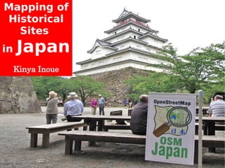
- 1. Mapping of Historical Sites in Japan Kinya Inoue
- 2. Do you know Japan? Japan Small Far Eastern Country
- 3. Japan 日本 Fukushima City Tokyo
- 4. 2008 A Year of My Mapping These are my Logs from last year. I love OSM.
- 5. Fukushima area April 2008
- 6. Fukushima area June 2009
- 7. I often map towns.
- 8. And often map highways. R115 in Soma city
- 9. I've mapped coastlines too. Haragama Harbor
- 10. I've also mapped some Volcanos. Azuma_kofuji Volcano
- 11. Mapping of Volcanos with my family.
- 12. I mapped this Roller Coaster.
- 14. Mapping of Historical Sites in Japan
- 15. Today I'll introduce some Mapping of historical sites in the East Japan area.
- 16. First, ZOJOJI Buddhist Temple ZOJOJI is a famous Buddhist temple in Tokyo.
- 17. ZOJOJI Temple of Buddhism
- 18. Mapping of ZOJOJI Log We can use only low resolution satellite photos in Japan. Landsat pictures are not clear enough for detailed mapping. Walking a lot and recording a lot of points are necessary for detailed mapping in Japan.
- 19. Before Mapping of ZOJOJI
- 20. After Mapping of ZOJOJI
- 21. YASUKUNI Shrine Shinto Shrine YASUKUNI Shrine is a famous Shinto Shrine .
- 22. YASUKUNI Shrine Shinto Shrine YASUKUNI Shrine is in Tokyo near the Imperial Palace.
- 23. YASUKUNI Shrine Shinto Shrine Five million people visit YASUKUNI shrine every year to commemorate who died in wars.
- 24. Mapping of YASUKUNI Shrine Log
- 25. Before Mapping of YASUKUNI Shrine
- 26. After Mapping of YASUKUNI Shrine
- 27. TSURUGAOKA Shrine Shinto Shrine
- 28. TSURUGAOKA Shrine Shinto Shrine
- 29. TSURUGAOKA Shrine Shinto Shrine
- 30. TSURUGAOKA Shrine Shinto Shrine TSURUGAOKA Shrine has about 800 years of history.
- 31. TSURUGAOKA Shrine Shinto Shrine The samurai practiced their religion at this shrine.
- 32. Mapping of TSURUGAOKA Shrine Log
- 33. Before Mapping of TSURUGAOKA Shrine
- 34. After Mapping of TSURUGAOKA Shrine
- 35. Tsuruga-jo Castle in Aizu Wakamatsu City
- 36. Tsuruga-jo Castle in Aizu Wakamatsu City Tsuruga-jo castle has about 600 years of history.
- 37. Tsuruga-jo Castle in Aizu Wakamatsu City Tsuruga-jo is in the center of Aizu Wakamatsu City. The castle is surrounded by the deep moats and the stone walls.
- 38. Tsuruga-jo Castle in Aizu Wakamatsu City
- 39. Tsuruga-jo Castle in Aizu Wakamatsu City
- 40. Tsuruga-jo Castle in Aizu Wakamatsu City This building was rebuilt 45 years ago.
- 41. Tsuruga-jo Castle in Aizu Wakamatsu City
- 42. Mapping of Tsuruga-jo Castle Logs
- 43. Mapping of Tsuruga-jo Castle Logs Now Tsuruga-jo Castle is a Public park. The outer perimeter Tsuruga-jo Castle is about 2.5km. I want to do detailed mapping. Then, I walked about 23km. around the outer regions of the castle on this day.
- 44. Mapping of Turuga-jo Castle Logs
- 45. I walked and walked.
- 46. I recorded a lot of points.
- 47. Before Mapping of Tsuruga-jo Castle
- 48. After Mapping of Tsuruga-jo Castle
- 49. After Mapping of Tsuruga-jo Castle
- 50. I ha ave s a e nt . d ry c ry ve I was concentrating very deeply about mapping the castle and walking around to various places around the castle.
- 51. I was walking and mapping on the retaining_wall that surronds the castle. Let's go map!!
- 52. Let's go map! Walk and Walk!
- 53. Let's go map! Walk and Walk!
- 54. OH NO! I was in a dangerous zone.
- 55. I noticed that I was standing on a wall behind some targets that were being used for Japanese Archery. Some pepole were practicing Archery. Training field for Archery.
- 56. Let's go map!
- 57. Mapping of Historical Sites in Japan Thank you ! Kinya Inoue Will you map in Japan ?