Accelerated Erosion and Sea Level Rise, The Case for Adaptive Policies
•
1 j'aime•3,179 vues

2012 March. Poster presenter. Research, Innovation and Scholarship Expo RISE2012, Northeastern University, Poster title, Accelerated Erosion and Sea Level Rise, The Case for Adaptive Policies.
Recommandé

Recommandé
Contenu connexe
Tendances
Tendances (19)
Similaire à Accelerated Erosion and Sea Level Rise, The Case for Adaptive Policies
Similaire à Accelerated Erosion and Sea Level Rise, The Case for Adaptive Policies (20)
Dernier
Dernier (20)
Accelerated Erosion and Sea Level Rise, The Case for Adaptive Policies
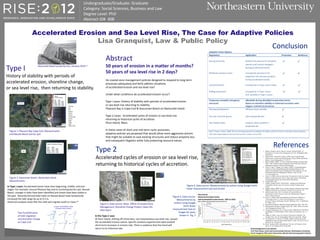
- 1. References 1. Beatley, Timothy, David J. Brower, Anna K. Schwab (2002). An Introduction to Coastal Zone Management, (2nd ed.), Washington (DC): Island Press. 2. Bernd-Cohen, Tin and M. Gordon, (1999). State Coastal Program Effectiveness in Protecting Natural Beaches, Dunes, Bluffs, and Rocky Shores. Coastal Management, 27:187-217. 3. Borrelli, Mark, (2009). 137 years of Shoreline Change in Pleasant Bay: 1868 - 2005. Technical report submitted to the Pleasant Bay Resource Management Alliance, Harwich, Massachusetts. 4. Giese, G. and S.T. Mague, S.S. Rogers, (2009). A Geomorphological Analysis of Nauset Beach/Pleasant Bay/Chatham Harbor For the Purpose of Estimating Future Configurations and Conditions, for The Pleasant Bay Resource Management Alliance, Cape Cod, MA. www.pleasantbay.org. 5. Giese, G. (2008). Land-sea interaction. Provincetown Center for Coastal Studies, Coastal Processes: Waves, Tides, and Currents. Woods Hole Oceanographic Institute Sea Grant Online Publications. 6. Google Earth, 2011. 7. Graham, Jennifer (2010). On the Rocks – healing our dysfunctional relationship with the coast, Nova Scotia, Canada: Ecology Action Centre. 8. Higgins, Megan (2008). Sea Level Rise Impacts on Beaches and Coastal Property, Sea Grant Law and Policy Journal, No. 43, pp. 44 – 65. 9. Kelley-Joseph, Peter, 2011. An Alaysis of Coastal Protection Experiences in Three Towns on Cape Cod, Massachusetts, Master’s Thesis, Tufts University. 10. Kraus, N. (2000). Inlet Geomorphology and Predictive Models. In: Proceedings of the U.S. Army Corps of Engineers Coastal Inlets Research Program Technology-Transfer Workshop; Feb 1-2; Melbourne, FL; Slides 1-46 11. Massachusetts Historic Shoreline Change spatial data, Mass. GIS, 2011. 12. Massachusetts Shoreline Change Project, 2011. Mass. Office of Coastal Zone Management, Boston, MA. 13. Nantucket Independent News, various articles, 2008-2010 by Peter Brace and Margaret. Carroll-Bergman. Photo credit, Peter Benchley, Jan. 13, 2010. 14. Oldale, R. (2001). Cape Cod, Martha’s Vineyard & Nantucket: The Geologic Story. Rev ed. Yarmouthport (MA): On Cape Publ., 208 pp. 15. Tol, Richard S.J., R. Klein, R. Nicholls, (2008). Towards Successful Adaptation to Sea-Level Rise along Europe's Coasts, Journal of Coastal Research, No. 242:432-442. 16. Wood, Timothy (2005). Breakthrough: The Story of Chatham’s North Beach. 6th ed. Chatham (MA): Hyora Publ. Undergraduate/Graduate: Graduate Category: Social Sciences, Business and Law Degree Level: PhD Abstract ID# 408 Accelerated Erosion and Sea Level Rise, The Case for Adaptive Policies Lisa Granquist, Law & Public Policy Abstract 50 years of erosion in a matter of months? 50 years of sea level rise in 2 days? Do coastal zone management policies designed to respond to long term processes adequately and fairly address situations of accelerated erosion and sea level rise? Under what conditions do accelerated erosion occur? Type I cases: History of stability with periods of accelerated erosion or sea level rise returning to stability. Pleasant Bay in Cape Cod & Siasconset Beach on Nantucket Island. Type 2 cases: Accelerated cycles of erosion or sea level rise returning to historical cycles of accretion. Plum Island, Mass. In these cases of short and mid-term cyclic processes, adaptive policies are proposed that would allow more aggressive actions that might be suitable to save existing structures and reduce property loss and subsequent litigation while fully protecting resource values. Adaptive Policy Options Regulatory Application Protection Resiliency Zoning variances Stream-line process for property owners and coastal managers during accelerated events Wetlands resource areas Incorporate provisions for expansion into private property during accelerated events. Living shoreline1 Incorporate in Type I and II areas Rolling easements Incorporate in Type I areas and possibly in Type II areas Temporary movable emergency structures Allowable during identified accelerated events. Return to shoreline stability or historical accretion rates triggers removal of structures. Floating breakwaters offshore shore parallel Pre-cast concrete groins shore perpendicular Geo-textile tubes onshore shore parallel or perpendicular Note 1: Swann, LaDon, 2008. The Use of Living Shorelines to Mitigate the Effects of Storm Events on Dauphin Island, Alabama, USA, Mississippi-Alabama Sea Grant Consortium, Auburn University. Type I History of stability with periods of accelerated erosion, shoreline change, or sea level rise, then returning to stability. 83.67 ft March 1995 38.15 ft Dec 2001 42.64 ft March 2005 53.29 ft April 2005 84.01 ft July 2007 52.27 ft April 2008 77.8 ft July 2008 17.61 ft July 2010 0 10 20 30 40 50 60 70 80 90 Mar-95 Oct-95 May-96 Dec-96 Jul-97 Feb-98 Sep-98 Apr-99 Nov-99 Jun-00 Jan-01 Aug-01 Mar-02 Oct-02 May-03 Dec-03 Jul-04 Feb-05 Sep-05 Apr-06 Nov-06 Jun-07 Jan-08 Aug-08 Mar-09 Oct-09 May-10 Feet from vegetation line to high water line Date of Measurement Plum Island Historical Accretion Cycles and Accelerated Erosion Events, 1995 to 2010 with trendline and accelerated erosion events in red Figure 1: Pleasant Bay Cape Cod, Massachusetts and Nauset Beach barrier spit Figure 2: Siasconset Beach, Nantucket Island, Massachusetts Type 2 Accelerated cycles of erosion or sea level rise, returning to historical cycles of accretion. In Type I cases: Accelerated events have clear beginning, middle, and end stages. For example, around Pleasant Bay and its enclosing barrier spit, Nauset Beach, changes in tides have been identified and shoals have been stable in the past. Recently-formed tidal inlets on Nauset Beach have temporarily increased the tide range by up to 0.3 m. Historical analyses show that this inlet will migrate south or close.3,4 Pleasant Bay and Nauset Beach: Recent accelerated events: 1987, 1990, 2007, 2008, 2010 Figure 3, Data source: Mass. Office of Coastal Zone Management, Shoreline Change Project, Mass GIS data layers Figure 4, Data source: Measurements by author using Google Earth linear measurement tool on images for years shown in Fig. 5 Figure 5, Data source: Measurements by author using Google Earth linear measurement tool and ArcGIS In the Type 2 case: At Plum Island, shifting off-shore bars, not instantaneous sea level rise, caused the accelerated erosion events. Specific locations experienced rapid isolated short-term increases in erosion rate. There is evidence that the trend will return to its historical rate. Acknowledgement to my advisers Prof. Peter Rosen, Earth and Environmental Sciences, Northeastern University Porter Hoagland, PhD, Senior Researcher, Woods Hole Oceanographic Institute Conclusion Two hundred years of inlet migration and shoreline change on Cape Cod Siasconset Beach property loss, January 2010.13