Water is constantly circulating through the hydrologic cycle between the oceans, atmosphere, and land. It moves through stages of evaporation, transpiration, condensation, precipitation, collection in rivers, lakes, and underground, and its return to the oceans in an endless, ceaseless interchange. The hydrologic cycle involves storage of water in various reservoirs on Earth's surface and underground, and transfer between reservoirs in solid, liquid, and gas forms through processes like evaporation and precipitation.
1. Title Page Photo
“Water is the one substance from which the earth can
conceal nothing; it sucks out its innermost secrets and
brings them to our very lips.”—Jean Giraudoux
lips.”
(U.S.G.S. Water Quotes, http://ct.water.usgs.gov/EDUCATION/morewater.htm)
http://ct.water.usgs.gov/EDUCATION/morewater.htm)
Vocabulary
aquifers (p. 281) lake (p. 273) thermohaline
artesian well (p. 283) marsh (p. 278) circulation (p. 269)
global conveyer-belt permafrost (p. 273) tidal bore (p. 268)
circulation (p. 269) permeability (p. 280) tidal range (p. 267)
groundwater (p. 281) porosity (p. 280) tides (p. 267)
hydrologic cycle (p. runoff (p. 263) waterless zone (p.
261) salinity (p. 266) 283)
iceberg (p. 271) subartesian (well) (p. water table (p. 281)
ice floe (p. 271) 283) zone of aeration (p.
ice pack (p. 271) swamp (p. 278) 281)
ice shelf (p. 271) zone of confined water
(p. 282)
zone of saturation (p.
281)
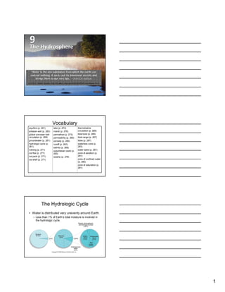
The Hydrologic Cycle
• Water is distributed very unevenly around Earth.
– Less than 1% of Earth’s total moisture is involved in
the hydrologic cycle.
1
2. The Hydrologic Cycle
• A series of storage
areas interconnected
by various transfer
processes, in which
there is a ceaseless
interchange of
moisture in terms of
its geographical
location and its
physical state.
The Hydrologic Cycle
• Surface-to-Air Water
Movement
• Air-to-Surface Water
Movement
• Movement on and
Beneath Earth’s
Surface
• Residence Times
Surface-to-Air Water Movement
• Evaporation is responsible for most of the moisture that
enters the atmosphere from Earth’s surface.
– Of the moisture evaporated, more than 84% comes from ocean
surfaces.
– The water evaporated becomes water vapor, and though it stays
in atmosphere only briefly (hours to days), it can travel a
considerable distance, either vertically or horizontally.
2
3. Air-to-Surface Water Movement
• Water vapor will either condense to liquid water or
sublimate to ice to form cloud particles.
– Clouds drop precipitation (rain, snow, sleet, hail).
– Precipitation and evaporation/transpiration balance in time.
• They do not balance in place.
– Evaporation exceeds precipitation over oceans.
– Precipitation exceeds evaporation over lands.
Movement on and Beneath Earth’s
Surface
• Runoff—flow of water from land to oceans by
overland flow, streamflow, and groundwater flow.
– Runoff is why the oceans do not dry up and continents
become flooded despite the imbalance of evaporation
and precipitation through space (oceans and
continents).
– Runoff water amounts to 8% of all moisture circulating
in global hydrologic cycle.
Residence Times
• At any given
movement, the
atmosphere contains
only a few days’
potential precipitation.
– Residence time of a
molecule of water can
be hundreds of
thousands of years to
only a few minutes.
3
4. The Oceans
• Knowledge of seas has
been very limited until
very recently.
– Only in about last four
decades have we
developed technology that
allows us to catalog and
measure details of ocean
environment.
– The “world ocean” has a
surface area of 360 million
square kilometers and
contains 1.32 billion cubic
kilometers of salt water.
The Oceans
• Just one ocean, which is divided into four principal parts:
– Pacific
– Atlantic
– Indian
– Arctic
• Most smaller bodies of water are considered portions of ocean.
– A few are so narrowly connected that they warrant separate consideration.
– Examples are the Black Sea, Mediterranean Sea, and Hudson Bay.
4
5. Characteristics of Ocean Waters
• Significant difference
from place to place.
– Almost all known
minerals found to
some extent in
seawater, but sodium
and chloride most
important.
• Salinity—a measure of
the concentration of
dissolved salts.
Characteristics of Ocean Waters
• Geographic
distribution of surface
salinity varies
because of
– Varying evaporation
rates
– Varying fresh water
discharge rates.
Characteristics of Ocean Waters
• Temperatures decrease
with increasing latitude.
• Western sides of oceans
nearly always warmer
than eastern margins
(movement of major
ocean currents).
– Density varies with
temperature, degree of
salinity, and depth.
5
6. Movement of Ocean Waters
• Most motion occurs in
waves, currents, and
tides.
– Affects surface more
than deeper water.
– Disturbances in
Earth’s crust under
ocean can trigger
motion.
Tides
• Tides cause the
greatest vertical
movements of ocean
waters; can also
cause horizontal
movement.
– Rhythmic oscillations
about every 6 hours,
from gravitational
attraction of nearby
heavenly bodies.
Causes of Tides
• Although both the Sun and
Moon have an influence on
the Earth’s tides, because of
its considerably greater
distance, the Sun produces
a smaller percentage of
Earth’s tides than does the
Moon.
– As Earth rotates tidal
progression appears to
move westward.
– There are two tidal cycles a
day.
• Two high tides and two low
tides every 25 hours.
6
7. Causes of Tides
• Tidal magnitude varies
greatly in time and place.
– Water flows toward the
coast in a period of 6 hours
and 13 minutes in what is
known as a flood tide.
– After reaching high tide, the
water then begins to
recede over a period of 6
hours and 13 minutes in
what is known as an ebb
tide.
– Once the water has
reached its lowest level,
the cycle begins again.
Tidal range
• Refers to the vertical
distance in elevation
between the high and low
tide.
– Changes in the positions of
Earth, Sun, and Moon have
influences on periodic
variations in tidal ranges.
• When all are aligned, the
Earth experiences spring
tides.
• When out of alignment,
the Earth experiences
neap tides.
Tidal range
• Tidal range also
affected by distance
of Earth to Moon.
– During the Moon’s
perigee (its closest
distance to the Earth),
tidal ranges are
greater than when it is
at its apogee (its
farthest distance from
the Earth).
7
8. Global Variations in Tidal Range
• Coastline configuration
and shape also have an
influence on tidal ranges.
– Greatest tidal range found
in Bay of Fundy in eastern
Canada.
– A tidal bore (a wall of sea
water) several centimeters
to more than a meter high
rushes up the Petitcodiac
River in New Brunswick.
• Inland bodies of water
experience the smallest
tidal ranges.
Currents
• Currents shift water both
horizontally and vertically.
– Primarily caused by wind
flow, but also by contrasts
in temperature and salinity.
– Influenced by size and
shape of particular ocean,
configuration and depth of
sea bottom, and Coriolis
effect.
Deep Ocean Circulation
• Deep ocean circulation occurs because of differences in
water density that arises from differences in salinity and
temperature.
– This circulation is also known as the thermohaline circulation.
– Sinking happens predominantly at higher latitudes because more
fresh water is locked up in glacial ice, which causes ocean water
to be more saline and denser in these regions.
8
9. Global Conveyor-belt Circulation
• Circulation pattern formed from deep ocean
water movement through thermohaline
circulation combined with surface currents
(Figure 9-10).
Waves
• Waves tend to be just
shapes, with very little
forward progress.
Permanent Ice/The Cryosphere
• Second largest
storage reservoir for
moisture (still
minuscule in
comparison to
ocean).
– Land portion of ice is
larger than oceanic
ice.
9
10. Permanent Ice/The Cryosphere
• Ocean ice has several
names
– Ice pack—an extensive
and cohesive mass of
floating ice.
– Ice shelf—a massive
portion of a continental ice
sheet that projects out over
sea.
– Ice floe—a large, flattish
mass of ice that breaks off
from larger ice bodies and
floats independently.
– Iceberg—a chunk of
floating ice that breaks off
from an ice shelf or glacier.
Permanent Ice/The Cryosphere
• Oceanic ice is made up of fresh
water because the ice crystals
do not take in the minerals of
seawater.
– Recently, several large, once-
stable ice shelves have broken
off of Antarctica.
Permafrost
• Permanent ground ice
of permanently frozen
subsoil; makes up
most of ice beneath
land surface.
10
11. Surface Waters
• Make up only 0.25%
of world’s total
moisture supply.
– Lakes
– Swamps and Marshes
– Rivers and Streams
Lakes
• A body of water
surrounded by land.
– Lakes make up more than
90% of surface water of the
continents.
– More than 40% of lake
water is salt water.
– Lakes distributed unevenly
through world.
– Most common where
glaciers had been.
Lakes
• Lake genesis and continued existence occurs
through two conditions:
1. Some sort of natural basin having a restricted outlet:
2. Sufficient inflow of water to keep the basin at least
partly filled.
11
12. Human Alteration of Natural Lakes
• Diversion of streams
by humans has had a
large influence on
reducing the volume
of some lakes.
• Mono Lake, CA, has
been reduced by 50%
of its previous
volume.
• The destiny of most
lakes is to disappear.
Reservoirs
• Creation of artificial
lakes has had
immense ecological
and economic
consequences, not
always beneficial.
Swamps and Marshes
• Swamp—water body with
water-tolerant plants,
predominantly trees.
• Marsh—water body with
water-tolerant plants,
primarily grasses and
sedges.
– Both are flattish surface
areas that are submerged
in water at least part of the
time but shallow enough to
permit growth of water-
tolerant plants.
12
13. Rivers and Streams
• Physical geographers call any flowing water a
stream, no matter size.
• Drainage basin is all the land area drained by a
river and its tributaries.
Underground Water
• The total amount of water
underground is more than
2.5 times that in lakes
and streams.
– Underground water more
widely distributed than
surface water.
• Quantity sometimes
limited;
• Quality sometimes poor;
• Sometimes at great depth.
Underground Water
• All underground water originally
comes from above.
• Two factors affect underground
water flow:
1. Porosity—a measure of the
capacity of rock or soil to hold
water and air; the percentage of
total volume of a material that
consists of voids.
2. Permeability—capacity of soil or
rock to transmit water;
determined by the size of pores
and by the degree of
interconnectedness.
• Interstices—the pore spaces; a
labyrinth of interconnecting
passageways among the soil
particles that makes up nearly
half the volume of an average
soil.
13
14. Underground Water
• Aquifer—where underground
water is stored; a permeable
subsurface rock layer that can
store, transmit, and supply
water.
• Aquiclude—an impermeable
rock layer that hinders or
prevents water movements.
Excludes water because of
high density, or as in case of
clay, because interstices are
many but too small to transmit
water.
Hydrologic Zones
• Underground layers
involved in general
distribution of
underground water:
– Zone of aeration
– Zone of saturation
– Zone of confined water
– Waterless zone
Hydrologic Zones
• Zone of aeration—the
topmost hydrologic zone
within the ground, which
contains a fluctuating
amount of moisture (soil
water) in the pore spaces
of the soil (or soil and
rock).
– A mixture of solids, water,
and air; of variable depth.
14
15. Hydrologic Zones
• Zone of saturation—the
second hydrologic zone
below the surface of the
ground, whose uppermost
boundary is the water table.
The pore spaces and
cracks in the bedrock and
the regolith of this zone are
fully saturated.
– Groundwater—water found
in the zone of saturation.
– Water table—the top of the
zone of saturation within
the ground.
• Where water table
intersects Earth’s surface,
water flows out.
• A lake, swamp , marsh, or
permanent stream is
almost always an
indication that the water
table reaches the surface
there.
Hydrologic Zones
• Perched water table—occurs when a
localized zone of saturation develops
above an aquiclude.
• Cone of depression—occurs when
water is removed from well faster than
underground water can replace it; this
lowers the water table, which becomes
the approximate shape of an inverted
cone in the immediate vicinity of well.
• Zone of confined water—the third
hydrologic zone below the surface of
the ground, separated from zone of
saturation by impermeable rock.
– Occurs in many, but not most parts of
world.
– It contains one or more permeable rock
layers (aquifers) into which water can
infiltrate.
– If drilled into, confining pressure will
force water to rise in the well.
Hydrologic Zones
• Piezometric surface—the
elevation to which water will rise
under natural confining pressure
in a well.
– Artesian well—the free flow that
results when a well is drilled from
the surface down into a zone of
confined water and the confining
pressure is sufficient to force the
water to the surface without
artificial pumping.
– Subartesian well—the free flow
that results when a well is drilled
from the surface down into a
confined aquifer but which
requires artificial pumping to raise
the water to the surface because
the confining pressure forces the
water only part way up the well
shaft.
15
16. Hydrologic Zones
• Waterless zone—the
lowermost hydrologic
zone that generally
begins several kilometers
or miles beneath the land
surface and is
characterized by the lack
of water in pore spaces
due to the great pressure
and density of the rock.
Groundwater Mining
• Accumulation of
groundwater is tediously
slow, but humans can
use it up rapidly.
• High rates of groundwater
use can be likened to
mining because a finite
resource is being
removed with no hope of
replenishment.
Groundwater Mining
• Largest U.S. aquifer—
Ogallala, underlies 585,000
square km (225,000 square
mi) of eight states.
– Water accumulated here for
some 30,000 years.
– Farmers began to tap into it in
early 1930s.
• Water table is sinking.
– Used to take 50-foot wells,
now some 150 to 250 feet (45
to 75 meters) to access water.
– Less careful neighbors can
harm those farmers who are
trying to be very conservative
in their water use.
16
17. Groundwater Mining
• Regional variations in
saturated thickness.
– Nebraska Sandhills
are in the best shape
with great thickness,
small usage, and a
rapid recharge rate.
– The 13 counties of
southwestern Kansas
have withdrawal rates
that far exceed the
recharge rate.
People and the Environment:
Oceans Becoming More Acidic
• The oceans take in carbon dioxide and form carbonic acid.
• As a result of increased carbon emissions from industrialization, the
oceans are estimated to be more acidic than they were during the
pre-industrial era.
• It is estimated that the pH of the oceans could drop to 7.7 by the end
of the century.
• The possible consequences of a slightly more acidic ocean are as
follows:
• The limiting of the growth of organisms such as coral polyps and
foraminifera.
• Creatures such as these will have a difficult time building their shells
because there are fewer calcium ions in acidic seawater.
• This could lead to the decline of coral reefs that provide habitats for
many organisms.
• Foraminifera are at the bottom of the food web so their decline could
possibly affect other organisms higher up the food web.
People and the Environment:
Thawing Permafrost in Alaska
• Permafrost, permanently frozen soil, is abundant in Alaska.
• Active layer—the upper 30 to 100 centimeters of the soil that thaws
during the summer.
• Beneath the active layer, the soil is frozen to a depth of
approximately 50 meters.
• Higher average temperatures have led to ground temperatures high
enough to melt the permafrost.
• Problems associated with melting of permafrost:
• Wet thermokarst conditions—where the ground surface subsides
and it becomes saturated with water.
• This in turn leads to the subsidence of structures such as roads and
pipelines.
• This also makes many roads impassible.
• May also lead to an increase in the activity of microorganisms in the
soil, which in turn will decompose organic material.
• This will then release carbon dioxide that will contribute to further
warming.
17
18. Focus: The Aral Sea and Lake
Chad
• Within the last half century, two of the largest lakes in the world (Aral
Sea, Uzbekistan/Kazakhstan and Lake Chad, Central Africa) have
been diminished to a fraction of their former sizes.
• Aral Sea
• 1960s Soviet irrigation projects diverted vast quantities of water from
the two rivers that flow into the Aral Sea.
• Today the Aral Sea is 25% of its former size.
• This destroyed the fishing industry and has generated choking wind-
blown dust and salt from the dry lake bottom.
• Recent reengineering of the Syr Darya River will allow the northern
remnant of the Aral Sea to remain near its current size.
• The southern portion of the sea will most likely disappear within a
couple of decades.
• Lake Chad
• Ongoing drought has reduced the lake to about 10% of its former
size.
• Some water diversion projects have contributed to the problem, but
the greatest cause is climate change in the region.
– Human Alteration
of Natural Lakes
– Fig. 9-C. Aral Sea is
shrinking due to dam
construction and diversion
of water for irrigation of
agricultural land.
18
19. • Aral Sea
– Fig. 9-18
People and the Environment:
Subsidence From Groundwater
Extraction
• Continued extraction of groundwater can lead to the compaction of
aquifer sediments.
• Especially a problem if the rate of groundwater extraction exceeds
the rate of recharge.
• Several U.S. regions have been affected by this.
• In Las Vegas, NV, the land has subsided as much as 2 meters since
the 1950s.
• Fissures have developed on the surface, and well casings have
been damaged.
• Satellite Interferometric Synthetic Aperture Radar (InSAR) allows for
the monitoring of ground subsidence.
• Bounced radar signals measure the distance, and the change in
distance through time, from the satellite and ground surface.
• This technology also allows scientists to detect and monitor new
faults.
09_25PE-E.JPG
19
20. Summary
• The hydrosphere encompasses all moisture
in, on, and above Earth.
• The hydrological cycle is the ceaseless
interchange of moisture between water
storage areas on Earth.
• Earth’s water storage areas include the
oceans, glaciers, lakes, marshes and
swamps, rivers and streams, and
underground aquifers.
• More than 97 percent of all moisture is
contained in the world ocean, which
generally is subdivided into four major
parts—Pacific, Atlantic, Indian, and Arctic.
• About 2 percent of the world’s moisture is
locked up in ice. Most of this in in land ice
(glaciers) and a small part is in floating sea
ice.
• Surface waters contain only a tiny fraction of
the world’s water supply.
• Underground water is more widely distributed
than surface water, but its availability and
quality vary considerably from place to place.
20