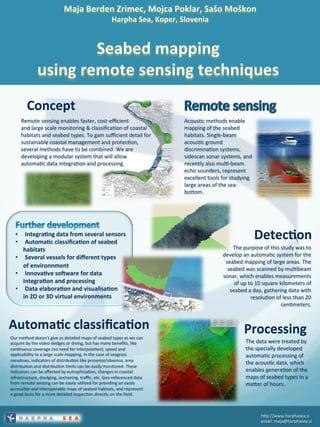
SlideShare une entreprise Scribd logo
1  sur  1
Télécharger pour lire hors ligne
•  	
  Integra)ng	
  data	
  from	
  several	
  sensors	
  
•  	
  Automa)c	
  classifica)on	
  of	
  seabed	
  	
  
habitats	
  
•  	
  Several	
  vessels	
  for	
  different	
  types	
  	
  
of	
  environnment	
  
•  	
  Innova)ve	
  so<ware	
  for	
  data	
  	
  
integra)on	
  and	
  processing	
  
•  	
  Data	
  elabora)on	
  and	
  visualisa)on	
  	
  
in	
  2D	
  or	
  3D	
  virtual	
  environments	


Acous'c	
  methods	
  enable	
  
mapping	
  of	
  the	
  seabed	
  
habitats.	
  Single-­‐beam	
  
acous'c	
  ground	
  
discrimina'on	
  systems,	
  
sidescan	
  sonar	
  systems,	
  and	
  
recently	
  also	
  mul'-­‐beam	
  
echo	
  sounders,	
  represent	
  
excellent	
  tools	
  for	
  studying	
  
large	
  areas	
  of	
  the	
  sea-­‐
bo<om.	
  	
  
Detec)on	
  
The	
  purpose	
  of	
  this	
  study	
  was	
  to	
  
develop	
  an	
  automa'c	
  system	
  for	
  the	
  
seabed	
  mapping	
  of	
  large	
  areas.	
  The	
  
seabed	
  was	
  scanned	
  by	
  mul'beam	
  
sonar,	
  which	
  enables	
  measurements	
  
of	
  up	
  to	
  10	
  square	
  kilometers	
  of	
  
seabed	
  a	
  day,	
  gathering	
  data	
  with	
  
resolu'on	
  of	
  less	
  than	
  20	
  
cen'meters.	
  	
  
Concept	
  
Remote	
  sensing	
  enables	
  faster,	
  cost-­‐efficient	
  	
  
and	
  large	
  scale	
  monitoring	
  &	
  classifica'on	
  of	
  coastal	
  
habitats	
  and	
  seabed	
  types.	
  To	
  gain	
  sufficient	
  detail	
  for	
  
sustainable	
  coastal	
  management	
  and	
  protec'on,	
  
several	
  methods	
  have	
  to	
  be	
  combined.	
  We	
  are	
  
developing	
  a	
  modular	
  system	
  that	
  will	
  allow	
  
automa'c	
  data	
  integra'on	
  and	
  processing.	
  	
  
The	
  data	
  were	
  treated	
  by	
  
the	
  specially	
  developed	
  
automa'c	
  processing	
  of	
  
the	
  acous'c	
  data,	
  which	
  
enables	
  genera'on	
  of	
  the	
  
maps	
  of	
  seabed	
  types	
  in	
  a	
  
ma<er	
  of	
  hours.	
  	
  
Processing	
  
h<p://www.harphasea.si	
  
email:	
  maja@harphasea.si	
  
Our	
  method	
  doesn't	
  give	
  as	
  detailed	
  maps	
  of	
  seabed	
  types	
  as	
  we	
  can	
  
acquire	
  by	
  the	
  video	
  sledges	
  or	
  diving,	
  but	
  has	
  many	
  benefits,	
  like	
  
con'nuous	
  coverage	
  (no	
  need	
  for	
  interpola'on),	
  speed	
  and	
  
applicability	
  to	
  a	
  large	
  scale	
  mapping.	
  In	
  the	
  case	
  of	
  seagrass	
  
meadows,	
  indicators	
  of	
  distribu'on	
  like	
  presence/absence,	
  area	
  
distribu'on	
  and	
  distribu'on	
  limits	
  can	
  be	
  easily	
  monitored.	
  These	
  
indicators	
  can	
  be	
  affected	
  by	
  eutrophica'on,	
  changes	
  in	
  coastal	
  
infrastructure,	
  dredging,	
  anchoring,	
  traffic,	
  etc.	
  Geo-­‐referenced	
  data	
  
from	
  remote	
  sensing	
  can	
  be	
  easily	
  u'lized	
  for	
  providing	
  an	
  easily	
  
accessible	
  and	
  interoperable	
  maps	
  of	
  seabed	
  habitats,	
  and	
  represent	
  
a	
  good	
  basis	
  for	
  a	
  more	
  detailed	
  inspec'on	
  directly	
  on	
  the	
  field.	
  	
  
Automa)c	
  classifica)on	


Contenu connexe

Tendances

Hydrographic Survey Validation and Chart Adequacy Assessment Using Automated ...
Hydrographic Survey Validation and Chart Adequacy Assessment Using Automated ...Hydrographic Survey Validation and Chart Adequacy Assessment Using Automated ...
Hydrographic Survey Validation and Chart Adequacy Assessment Using Automated ...
Giuseppe Masetti
 
Benefits of 3-D Visualization for Drilling, Groundwater Availability, Groundw...
Benefits of 3-D Visualization for Drilling, Groundwater Availability, Groundw...Benefits of 3-D Visualization for Drilling, Groundwater Availability, Groundw...
Benefits of 3-D Visualization for Drilling, Groundwater Availability, Groundw...
Texas Alliance of Groundwater Districts
 
MINERAL EXPLORATION USING ASTER IMAGE
MINERAL EXPLORATION USING ASTER IMAGE MINERAL EXPLORATION USING ASTER IMAGE
MINERAL EXPLORATION USING ASTER IMAGE
Abhiram Kanigolla
 
Southside Green - Team 6
Southside Green - Team 6Southside Green - Team 6
Southside Green - Team 6
M. Damon Weiss
 
Mineral mapping and applications of imaging spectroscopy
Mineral mapping and applications of imaging spectroscopyMineral mapping and applications of imaging spectroscopy
Mineral mapping and applications of imaging spectroscopy
Remote Sensing GEOIMAGE
 
Remote Sensing And GIS Application In Mineral , Oil , Ground Water MappingMin...
Remote Sensing And GIS Application In Mineral , Oil , Ground Water MappingMin...Remote Sensing And GIS Application In Mineral , Oil , Ground Water MappingMin...
Remote Sensing And GIS Application In Mineral , Oil , Ground Water MappingMin...
Swetha A
 
Course ENG4903 Professional Practice 2
Course ENG4903 Professional Practice 2Course ENG4903 Professional Practice 2
Course ENG4903 Professional Practice 2
John Worrall
 

Tendances (20)

Hydrographic Survey Validation and Chart Adequacy Assessment Using Automated ...
Hydrographic Survey Validation and Chart Adequacy Assessment Using Automated ...Hydrographic Survey Validation and Chart Adequacy Assessment Using Automated ...
Hydrographic Survey Validation and Chart Adequacy Assessment Using Automated ...
 
Benefits of 3-D Visualization for Drilling, Groundwater Availability, Groundw...
Benefits of 3-D Visualization for Drilling, Groundwater Availability, Groundw...Benefits of 3-D Visualization for Drilling, Groundwater Availability, Groundw...
Benefits of 3-D Visualization for Drilling, Groundwater Availability, Groundw...
 
Trusted Crowd-Sourced Bathymetry Project
Trusted Crowd-Sourced Bathymetry ProjectTrusted Crowd-Sourced Bathymetry Project
Trusted Crowd-Sourced Bathymetry Project
 
A Geospatial Inventory and Preliminary Valuation of Human Uses of Rhode Islan...
A Geospatial Inventory and Preliminary Valuation of Human Uses of Rhode Islan...A Geospatial Inventory and Preliminary Valuation of Human Uses of Rhode Islan...
A Geospatial Inventory and Preliminary Valuation of Human Uses of Rhode Islan...
 
Pydro & HydrOffice: Open Tools for Ocean Mappers
Pydro & HydrOffice: Open Tools for Ocean MappersPydro & HydrOffice: Open Tools for Ocean Mappers
Pydro & HydrOffice: Open Tools for Ocean Mappers
 
MINERAL EXPLORATION USING ASTER IMAGE
MINERAL EXPLORATION USING ASTER IMAGE MINERAL EXPLORATION USING ASTER IMAGE
MINERAL EXPLORATION USING ASTER IMAGE
 
Southside Green - Team 6
Southside Green - Team 6Southside Green - Team 6
Southside Green - Team 6
 
Ocean Globe, Ocean Geospatial Appliance
Ocean Globe, Ocean Geospatial ApplianceOcean Globe, Ocean Geospatial Appliance
Ocean Globe, Ocean Geospatial Appliance
 
INMARTECH 2018 - G.Masetti & P.Johnson - Sound Speed Management and Environme...
INMARTECH 2018 - G.Masetti & P.Johnson - Sound Speed Management and Environme...INMARTECH 2018 - G.Masetti & P.Johnson - Sound Speed Management and Environme...
INMARTECH 2018 - G.Masetti & P.Johnson - Sound Speed Management and Environme...
 
IUKWC Workshop Nov16: Developing Hydro-climatic Services for Water Security –...
IUKWC Workshop Nov16: Developing Hydro-climatic Services for Water Security –...IUKWC Workshop Nov16: Developing Hydro-climatic Services for Water Security –...
IUKWC Workshop Nov16: Developing Hydro-climatic Services for Water Security –...
 
DSD-INT 2020 Real Time Hydrologic, Hydraulic and Water Quality Forecasting in...
DSD-INT 2020 Real Time Hydrologic, Hydraulic and Water Quality Forecasting in...DSD-INT 2020 Real Time Hydrologic, Hydraulic and Water Quality Forecasting in...
DSD-INT 2020 Real Time Hydrologic, Hydraulic and Water Quality Forecasting in...
 
Mineral mapping and applications of imaging spectroscopy
Mineral mapping and applications of imaging spectroscopyMineral mapping and applications of imaging spectroscopy
Mineral mapping and applications of imaging spectroscopy
 
Remote Sensing And GIS Application In Mineral , Oil , Ground Water MappingMin...
Remote Sensing And GIS Application In Mineral , Oil , Ground Water MappingMin...Remote Sensing And GIS Application In Mineral , Oil , Ground Water MappingMin...
Remote Sensing And GIS Application In Mineral , Oil , Ground Water MappingMin...
 
Nearshore Hardbottom Monitoring: Alternative Methods
Nearshore Hardbottom Monitoring: Alternative MethodsNearshore Hardbottom Monitoring: Alternative Methods
Nearshore Hardbottom Monitoring: Alternative Methods
 
OceanSITES
OceanSITESOceanSITES
OceanSITES
 
DSD-INT 2019 SPIT - application of a novel sediment pathway visualization met...
DSD-INT 2019 SPIT - application of a novel sediment pathway visualization met...DSD-INT 2019 SPIT - application of a novel sediment pathway visualization met...
DSD-INT 2019 SPIT - application of a novel sediment pathway visualization met...
 
Course ENG4903 Professional Practice 2
Course ENG4903 Professional Practice 2Course ENG4903 Professional Practice 2
Course ENG4903 Professional Practice 2
 
The use of geoinformatics in mineral exploration and exploitation
The use of geoinformatics in mineral exploration and exploitationThe use of geoinformatics in mineral exploration and exploitation
The use of geoinformatics in mineral exploration and exploitation
 
On the Oceanography of Brazil’s Equatorial Margin: Hazardous Offshore Current...
On the Oceanography of Brazil’s Equatorial Margin: Hazardous Offshore Current...On the Oceanography of Brazil’s Equatorial Margin: Hazardous Offshore Current...
On the Oceanography of Brazil’s Equatorial Margin: Hazardous Offshore Current...
 
C1.06: US IOOS: Eyes on the Ocean - Zdenka Willis
C1.06: US IOOS: Eyes on the Ocean - Zdenka WillisC1.06: US IOOS: Eyes on the Ocean - Zdenka Willis
C1.06: US IOOS: Eyes on the Ocean - Zdenka Willis
 

Similaire à Poster Conservation biology

An Automated Approach of Shoreline Detection Applied to Digital Videos using ...
An Automated Approach of Shoreline Detection Applied to Digital Videos using ...An Automated Approach of Shoreline Detection Applied to Digital Videos using ...
An Automated Approach of Shoreline Detection Applied to Digital Videos using ...
Dwi Putra Asana
 
Underwater acoustic sensor network
Underwater acoustic sensor networkUnderwater acoustic sensor network
Underwater acoustic sensor network
Srija Kumar
 
OECD_PortugalKeynote_SatelliteTechnology_R1r00
OECD_PortugalKeynote_SatelliteTechnology_R1r00OECD_PortugalKeynote_SatelliteTechnology_R1r00
OECD_PortugalKeynote_SatelliteTechnology_R1r00
Keiran Millard
 
Article fishing zones
Article fishing zonesArticle fishing zones
Article fishing zones
Gopala Reddy
 
Paper id 25201423
Paper id 25201423Paper id 25201423
Paper id 25201423
IJRAT
 

Similaire à Poster Conservation biology (20)

An Automated Approach of Shoreline Detection Applied to Digital Videos using ...
An Automated Approach of Shoreline Detection Applied to Digital Videos using ...An Automated Approach of Shoreline Detection Applied to Digital Videos using ...
An Automated Approach of Shoreline Detection Applied to Digital Videos using ...
 
Analysis on Data Transmission in Underwater Acoustic Sensor Network for Compl...
Analysis on Data Transmission in Underwater Acoustic Sensor Network for Compl...Analysis on Data Transmission in Underwater Acoustic Sensor Network for Compl...
Analysis on Data Transmission in Underwater Acoustic Sensor Network for Compl...
 
How We Conduct Bathymetric Surveys?
How We Conduct Bathymetric Surveys?How We Conduct Bathymetric Surveys?
How We Conduct Bathymetric Surveys?
 
Underwater acoustic sensor network
Underwater acoustic sensor networkUnderwater acoustic sensor network
Underwater acoustic sensor network
 
OECD_PortugalKeynote_SatelliteTechnology_R1r00
OECD_PortugalKeynote_SatelliteTechnology_R1r00OECD_PortugalKeynote_SatelliteTechnology_R1r00
OECD_PortugalKeynote_SatelliteTechnology_R1r00
 
Underwater sensor network
Underwater sensor networkUnderwater sensor network
Underwater sensor network
 
Pipeline Depth Of Cover Surveys
Pipeline Depth Of Cover SurveysPipeline Depth Of Cover Surveys
Pipeline Depth Of Cover Surveys
 
Article fishing zones
Article fishing zonesArticle fishing zones
Article fishing zones
 
Remote Sensing and GIS for Coastal Management
Remote Sensing and GIS for Coastal ManagementRemote Sensing and GIS for Coastal Management
Remote Sensing and GIS for Coastal Management
 
D3602026041
D3602026041D3602026041
D3602026041
 
Underwater Sensor wireless Network
Underwater Sensor wireless NetworkUnderwater Sensor wireless Network
Underwater Sensor wireless Network
 
Underwater Object Recognition
Underwater Object RecognitionUnderwater Object Recognition
Underwater Object Recognition
 
Multi-Spectral Analysis of Satellite Imagery for Inventory of Sensitive Marin...
Multi-Spectral Analysis of Satellite Imagery for Inventory of Sensitive Marin...Multi-Spectral Analysis of Satellite Imagery for Inventory of Sensitive Marin...
Multi-Spectral Analysis of Satellite Imagery for Inventory of Sensitive Marin...
 
Paper id 25201423
Paper id 25201423Paper id 25201423
Paper id 25201423
 
Nick - Benefits of Using Combined Bathymetry and Side Scan Sonar in Shallow W...
Nick - Benefits of Using Combined Bathymetry and Side Scan Sonar in Shallow W...Nick - Benefits of Using Combined Bathymetry and Side Scan Sonar in Shallow W...
Nick - Benefits of Using Combined Bathymetry and Side Scan Sonar in Shallow W...
 
Underwater Object Detection and Tracking Using Electromagnetic Waves
Underwater Object Detection and Tracking Using Electromagnetic WavesUnderwater Object Detection and Tracking Using Electromagnetic Waves
Underwater Object Detection and Tracking Using Electromagnetic Waves
 
About the paper USC CINAPS Builds Bridges Observing and Monitoring the Southe...
About the paper USC CINAPS Builds Bridges Observing and Monitoring the Southe...About the paper USC CINAPS Builds Bridges Observing and Monitoring the Southe...
About the paper USC CINAPS Builds Bridges Observing and Monitoring the Southe...
 
SEG14_Wednesday_lr 8
SEG14_Wednesday_lr 8SEG14_Wednesday_lr 8
SEG14_Wednesday_lr 8
 
Reconnaissance for Hydrographic Survey Project
Reconnaissance for Hydrographic  Survey ProjectReconnaissance for Hydrographic  Survey Project
Reconnaissance for Hydrographic Survey Project
 
multibeam
multibeammultibeam
multibeam
 

Poster Conservation biology

  • 1. •   Integra)ng  data  from  several  sensors   •   Automa)c  classifica)on  of  seabed     habitats   •   Several  vessels  for  different  types     of  environnment   •   Innova)ve  so<ware  for  data     integra)on  and  processing   •   Data  elabora)on  and  visualisa)on     in  2D  or  3D  virtual  environments           Acous'c  methods  enable   mapping  of  the  seabed   habitats.  Single-­‐beam   acous'c  ground   discrimina'on  systems,   sidescan  sonar  systems,  and   recently  also  mul'-­‐beam   echo  sounders,  represent   excellent  tools  for  studying   large  areas  of  the  sea-­‐ bo<om.     Detec)on   The  purpose  of  this  study  was  to   develop  an  automa'c  system  for  the   seabed  mapping  of  large  areas.  The   seabed  was  scanned  by  mul'beam   sonar,  which  enables  measurements   of  up  to  10  square  kilometers  of   seabed  a  day,  gathering  data  with   resolu'on  of  less  than  20   cen'meters.     Concept   Remote  sensing  enables  faster,  cost-­‐efficient     and  large  scale  monitoring  &  classifica'on  of  coastal   habitats  and  seabed  types.  To  gain  sufficient  detail  for   sustainable  coastal  management  and  protec'on,   several  methods  have  to  be  combined.  We  are   developing  a  modular  system  that  will  allow   automa'c  data  integra'on  and  processing.     The  data  were  treated  by   the  specially  developed   automa'c  processing  of   the  acous'c  data,  which   enables  genera'on  of  the   maps  of  seabed  types  in  a   ma<er  of  hours.     Processing   h<p://www.harphasea.si   email:  maja@harphasea.si   Our  method  doesn't  give  as  detailed  maps  of  seabed  types  as  we  can   acquire  by  the  video  sledges  or  diving,  but  has  many  benefits,  like   con'nuous  coverage  (no  need  for  interpola'on),  speed  and   applicability  to  a  large  scale  mapping.  In  the  case  of  seagrass   meadows,  indicators  of  distribu'on  like  presence/absence,  area   distribu'on  and  distribu'on  limits  can  be  easily  monitored.  These   indicators  can  be  affected  by  eutrophica'on,  changes  in  coastal   infrastructure,  dredging,  anchoring,  traffic,  etc.  Geo-­‐referenced  data   from  remote  sensing  can  be  easily  u'lized  for  providing  an  easily   accessible  and  interoperable  maps  of  seabed  habitats,  and  represent   a  good  basis  for  a  more  detailed  inspec'on  directly  on  the  field.     Automa)c  classifica)on