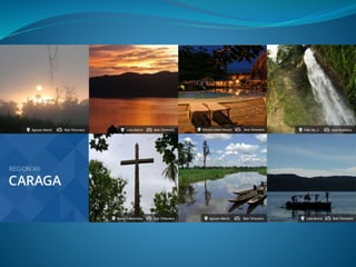
Region xiii (caraga)
•Télécharger en tant que PPTX, PDF•
105 j'aime•56,585 vues

it's more fun in CARAGA :)

Recommandé
Contenu connexe
Tendances
Tendances (20)
En vedette
En vedette (20)
Similaire à Region xiii (caraga)
Similaire à Region xiii (caraga) (20)
Dernier
Dernier (20)
Region xiii (caraga)
- 2. The history of Caraga can be traced back to the 15th century when explorers discovered the existence of “Kalagans”, believed to be of Visayan Origin in one of the three districts in Mindanao. The word Caraga originated from the Visayan word “Kalagan”: “Kalag” meaning soul or people and “An” meaning land The region have five provinces;Surigao del Norte, Surigao del Sur, Agusan del Norte, Agusan del Sur and Dinagat Islands. In 1960, Surigao was divided as Norte and Sur, and in June 1967, Agusan followed suit. On August 2, 1950, by virtue of Republic Act 523, the City Charter of Butuan was approved.
- 3. Caraga Region, situated in the northeast section of Mindanao, is between 8 00' to 10 30' N. latitude and 125 15' to 126 30' E. longitude. It is bounded on the north by the Bohol Sea; on the south by the provinces of Davao, Compostela Valley and Davao Oriental of Region XI; on the west by Bukidnon and Misamis Oriental of Region X; and on the east by the Philipine Sea and the Pacific Ocean. Caraga has a total land area of 1,902,980 hectares or 18,847.2 sq. km. This represents 6.3% of the country's total land area and 18.5% of the island of Mindanao. 47.6% of the total land area of the region belongs to the province of Agusan del Sur. Of the total land area, 71.22% is forestland and 28.78% is alienable and disposable land. Major land uses include forestland comprising 31.36% and 23.98% of agricultural and open spaces.
- 4. Caraga Region has Type II climate, with no pronounced wet and dry season. During the months of November to February, heavy rains are usually experienced in the region Caraga is considered as the richest region in terms of natural resources and it is considered as a . Its jewel lies in the regional’s vast forest, fertile mountains and valleys, seas, rivers, lakes, mineral deposits, people and other natural endowments. R.A. 7901 made this northeastern region as the new economic hub in Southern Philippines considering its vast potentials for ecotourism, industrial, mining, agri-industrial, and agricultural development.
- 5. Surigaonon is the primary language that is inherent to the region, is spoken by 33.21% of the households, followed by Butuanon by 15%; Kamayo, by 7.06%, and Manobo, by 4.73%. Cebuano is widely spoken by 33.79% of the households in the region. The rest speak Boholanon, by 5.87%; Hiligayon, by 2.87%; and other dialects by 7.20%. The 1995 census revealed that the dominant religion in the region was Roman Catholic, with the population of 1,397,343 or 79% of the total household population in Caraga.
- 7. SURIGAO DEL NORTE (The Surfing capital in the Philippines)
- 8. Founded June 16, 1960 Capital Surigao City Area Total 1,972.93 km2 (761.75 sq mi) Population (2010) • Total 442,588 • Rank 59th out of 81 • Density 220/km2(580/sq mi) Divisions • Independent cities 0 • Component cities 1 •Municipalities 20 • Barangays 335 Spoken languages Cebuano, Surigaonon, Tagalog, English
- 9. • Surigao del Norte is a group of islands at the rim of the Asian continental shelf. It is one of the four provinces of the newly created Caraga Region 13. The province is blessed with long stretches of white sand beaches, enchanting rock formations, mysterious caves, and vast mangrove forests. The strong waves in Siargao Island has made the province the . Once a quiet and pristine place, Surigao del Norte’s rural charm now caught the fancy of local and foreign tourists who frequent the province’s numerous islands. Over the years, Surigao del Norte has indeed become a shangri-la for visitors from all over the world, especially for surfers and body boarders. • on June 19, 1960, through Republic Act 2786 that Surigao province was divided to form Surigao del Sur and Surigao del Norte.
- 10. With a land are of 273,902 hectares or 2,739.02 square kilometers, Surigao del Norte ranks third in the Caraga Region in terms of land area which is equal to 0.99% of the total land area of the Philippines. It is composed of 27 municipalities where Surigao City is the provincial capital. The province boasts of lush virgin forests, a long stretch of white sand beaches with world-class surfing sites, magnificent rock formations, and abundant marine life. Surigao del Norte has the biggest deposits of nickel, gold, chromite, iron, gravel and sand, limestone and sillica.
- 33. Surigao del sur (Shangri-la by the Pacific)
- 34. Founded June 16, 1960 Capital Tandag Area Total 4,932.70 km2 (1,904.53 sq mi) Population Total (2010)561,219 • Rank 52nd out of 81 • Density 110/km2 (290/sq mi) Divisions • Independent cities 0 • Component cities 2 • Municipalities 17 • Barangays 309 • Spoken languages Surigaonon or/and Tandaganon, Kamayo, Cebuano, Manobo languages, Tagalog, English
- 35. Surigao del Sur was created as the 56th independent Philippine province on June 19, 1960 by virtue of House Bill No. 3058 also known as Republic Act No. 2786 authored by then Representative Reynaldo P. Honrado. It was formally created and inaugurated on September 18, 1960 at the capital town of Tandag, the seat of the Provincial Government. Its first appointed and elected Governor was the late Recaredo B. Castillo, followed by the late Governor Adela Serra Ty.
- 36. Surigao del Sur is naturally advantaged. It is located in the northeastern coast of Mindanao facing the Pacific Ocean. It is approximately 300 kilometers in length and 50 kilometers at its widest stretch. It is bounded on the northwest by the province of Surigao del Norte, on the southeast by Davao Oriental; on the east by the Pacific Ocean; and on the west and southwest by the province of Agusan del Norte and Agusan del Sur. The Diwata Mountain Ranges lines the northwestern boundaries of the province. The province falls under the second type of climate in the Philippines characterized by rainfall that is distributed throughout the year. Months with low level of rainfall are from July to October with September as the driest month. Wet months are from November to June with January as the wettest month.
- 47. Inside the International Doll House
- 56. AGUSAN DEL NORTE (Home of the Centenial Tree)
- 57. Founded June 17, 1967 Capital Cabadbaran City Area Total 2,730.24 km2 (1,054.15 sq mi) Population (2010) • Total 332,487 • Rank 63rd out of 81 • Density 120/km2 (320/sq mi) Divisions • Independent cities 1 • Component cities 1 • Municipalities 10 • Barangays 166 Spoken languages Cebuano, Tagalog, English, Surigaonon
- 58. Agusan was named after a Malay word “agasan” meaning “where water flows” probably because of a mighty river that traverses the area. By the time the Spaniards arrived, the natives were already trading with foreign merchants as evidenced by 10th century ceramics unearthed near Butuan. Some historians claimed that Magellan held the first mass in the Philippines in Masao at the mouth of the Agusan River, and not in Limasawa, Leyte, on Easter Sunday of 1521. Agusan del Norte was part of the province of Surigao during the Spanish Colonial Administration. By virtue of R.A. 1306 of 1914, it became an independent province of Agusan during the American Administration. On June 17, 1967, Congress passed R.A. 4979 dividing the province of Agusan into Agusan del Norte and Agusan del Sur.
- 59. Located in the northeastern part of Mindanao, it is bounded on the north by Butuan Bay and Surigao del Norte; east by Surigao del Sur; west by Misamis Oriental; and south and southwest by Agusan del Sur. Cebuano is the major dialect. Filipino and English are widely spoken. Minor dialects are Butuanon, Ilonggo, Mamanwa, Manobo, Higa-onon, Maranaw and Fukienese.
- 60. The province is located outside the typhoon belt and has no definite dry season. Rainfall is pronounced throughout the year occurring heavily from November to January. Temperature ranges from 22.8 C to 32.1 C. Relative humidity is 84%. Agriculture and forestry are the predominant occupations in the area. Its rich agricultural lands and climate are ideal for the growing of raw materials and plantation crops such as banana, mango, abaca, and coconut. Its grasslands are ideal for cattle raising while its lush virgin forest is a potential source of timber. Minerals such as limestones, marble, manganese and the province’s estimated 1,566,200 metric tons of gold deposits are generally untapped. The town of Kitcharao alone has 179 hectares of high quality limestone and marble with mineral reserves of at least 23,370,000 cubic meters.
- 62. Magellan Marker Erected in the time of Spanish District Gov. Jose Maria Carvallo in 1872, this edifce located at the mouth of Agusan river in present day Magallanes, is the site of the first catholic mass in Mindanao on April 8,1521. Magallanes, in the olden days was called Baug, formerly the site of Butuan.
- 79. Sumayajaw Festival - Held every August 14 during the town fiesta of Jabonga, is a thanksgiving celebration for the bounties showered by the Heavenly Father through the intercession of the Blessed Virgin Mary, the Lady of Assumpcion – patroness of Jabonga.
- 80. Lisagan Festival: Held every 3rd Sunday of October is an annual celebration tha t showcases the Mamanwa dance healing rituals. It is a re-enactment of a miraculous healing of a Mamanwa native in 1910 while dancing in front of the statue of the Blessed Virgin Mary. This statue was brought to Magallanes from Las Nieves, Barcelona
- 81. Araw ng Agusan del Norte: This is a founding anniversary celebration of the Province of Agusan del Norte every June 13-17. Activities: Trade Exhibit; State of the Province Address; Barangay Night; Employees Day; Peoples Day; Inter-Agency Sports Competition; Concert at the Park; Choral Competitions; Flatboat Race and a national 4 x 4 Race.
- 82. AGUSAN DEL SUR (Land of Golden Opportunities)
- 83. Founded June 17, 1967 Capital Prosperidad Area Total 9,989.52 km2 (3,856.98 sq mi) Population (2010) • Total 656,418 • Rank 46th out of 81 • Density 66/km2 (170/sq mi) Divisions • Independent cities 0 • Component cities 1 • Municipalities 13 • Barangays 314 Spoken languages Cebuano, Tagalog, English, Surigaonon, Butuanon, Manobo
- 84. The province of Agusan del Sur once shared one governance with its sister province, Agusan del Norte. However, Republic Act 4969, enacted on June 17, 1967, divided the Agusan province into two: Agusan del Sur and Agusan del Norte. Agusans pre-hispanic history was greatly influenced by the Madjapahit Empire. This can be attested through the discovery of the Golden Tara in 1960, in one of its towns, which is Maasam, Esperanza. The 8-inches gold image, that was retrieved along the river of Esperanza, originated from the Madjapahit Empire. The aborigines of Agusan were the ancestors of the present-day Mamanwas who were driven to the hinterlands by the waves of Malay immigrants from nearby Borneo, Celebes and Malaysia. These people, in turn, sought the protection of the interior jungles because of the forays and the constant raids of Moros. Being a sea-faring people, they confined themselves to the coastal areas where they started settlements, leaving the forestall area to the other native tribes.
- 85. It has a total land area of 896,550 hectares or 8,965.50 square kilometers, with flat and rolling topography crisscrossed with rivers. The Agusan River is the largest and cuts the province into two along North-South direction. Agusan del Sur is maybe one of the countrys richest gold deposits, it is called the GOLDEN COUNTRY of the Phillipines. It contributes to the estimated 5.5 billion metric tons of metallic and non-metallic ore reserves Caraga region possesses. Other minerals found in the area are limestone, marble, gypsum, manganese, phosphate rock, coal, andesite rock, chromite, quartz, gold, white clay, and sand & gravel. As part of Caraga region, it is also known to have the largest established timberland hectarage nationwide. In fact, it is envisioned to be the next timber corridor and food bowl in the region. Its major forestry and agricultural products are exotic tree species, rice, corn, coconut, cacao, coffee, banana, palm oil, and other agricultural resources.
- 87. In 1917 after a storm and flood, a 21-carat golden figurine of a female deity of Hindu was found by a Manobo woman on a muddy bank of Wawa River, a tributary of the large Agusan River. This ancient figure seated in lotus position weighs nearly 4 pounds which is the earliest known image identified to be an Indian in origin. The image corroborates a single cultural sphere that developed in the archipelagic regions of Southeast Asia during the height of trade between Butuan and the rest of the Sri Vijaya Empire.
- 93. Lolong, World‘s Largest Crocodile Lolong was the largest crocodile in captivity. He was an Indo-Pacific or saltwater crocodile measured at 20 ft 3 in (6.17 m), and weighed 2,370 lbs (1,075 kg), making him one of the largest crocodiles ever measured from snout-to-tail. In November 2011, Australian crocodile expert Dr. Adam Britton of National Geographic sedated and measured Lolong in his enclosure and confirmed him as the world's longest crocodile ever caught and placed in captivity. Lolong died in captivity at around 8 pm on 10 February 2013.
- 99. Dinagat Islands (Mystical Island, Province of Love and a Province of Ironies)
- 100. Founded December 2, 2006 Capital San Jose Area • Total -1,036.34 km2(400.13 sq mi) Area rank - 75th out of 81 Population (2010) • Total 126,803 • Rank 77th out of 81 • Density 120/km2 (320/sq mi) Divisions • Independent cities 0 • Component cities 0 • Municipalities 7 • Barangays 100 Spokenlanguages Cebuano, Surigaonon, Tagalog, English
- 101. Dinagat Islands had been a part of the First District of Surigao del Norte Province until becoming a province on its own on December 2, 2006 with the approval of Republic Act No. 9355, the Charter of the Province of Dinagat Islands, in a plebiscite. On February 11, 2010, the Supreme Court of the Philippines declared the creation of Dinagat Islands Province null and void on grounds of failure to meet land area and population requirements for the creation of local government units. Dinagat Islands then reverted to Surigao del Norte Province. On March 30, 2011, however, the Supreme Court reversed its ruling from the previous year, and upheld the constitutionality of RA 9355 and the creation of Dinagat Islands as a province.
- 102. Bounded on the North, starting from the desolation point is Surigao Strait; on the East by the Philippine Sea; on the South. East by Dinagat sound; on the South by Gahoc Channel and Nonoc Island; on the South-West by Awasan Bay, Hanigad Island and Hikdop Island; and on the West by Surigao Strait the province has no pronounced dry season but with a very pronounced maximum rainy season from November to January. Temperature ranges from a low of 21.1 ºC to 35ºC.
- 114. http://www.nnc.gov.ph/plans-and-programs/bns/item/141- caraga-region-history-and-geography http://en.wikipedia.org/wiki/Caraga http://itsmorefuninthephilippines.com/region-13-caraga/ http://visitmyphilippines.com/index.php?title=Allaboutth eRegion&Page=1&pid=2469 http://www.flyphilippines.biz/attractions_natural_surigao. php http://www.flyphilippines.biz/attractions_placesofinterest _surigao.php http://www.flyphilippines.com.ph/surigao/info.php http://harrybalais.com/travels/the-rich-poor-province-of-dinagat- islands/ http://itsmorefuninthephilippines.com/dinagat-island/ http://caraganon.com/2011/10/dinagat-islands-mystical-island- province-of-love/