Cloud Frontiers: A Deep Dive into Serverless Spatial Data and FME
Final Exam Extra Answers
1. What is the thickness of the continental lithosphere? Do the continents have roots that extend to
depths of several hundred kilometers in the mantle?
The continental lithosphere is comprised of the crust and the upper mantle which is jointed together
by the moho discontinuity, with a total thickness of about 150km. Yes. Continental shields have high-
velocity roots or “keels” that extend down for several hundred kilometers in the mantle.
The Earth’s Lithosphere is composed of the crust and upper mantle, which is separated by the MOHO
discontinuity. Forty percent (40%) of the Earth is composed of Continental Lithosphere and is divided in
to 12 major plates. The continental Lithosphere is thicker than that of the oceanic. Mechanical Models
of the upper mantle indicate that the Earth’s Lithosphere thickness is about 150 km. However, some
other models such as the thermal model, put the upper mantle boundary at the rock melting point of
1200 degree centigrade depth, which could indicate the continental Lithosphere thickness to be twice as
tick as predicted by the mechanical models.
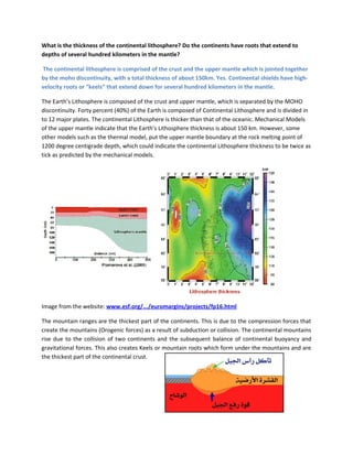
Image from the website: www.esf.org/.../euromargins/projects/fp16.html
The mountain ranges are the thickest part of the continents. This is due to the compression forces that
create the mountains (Orogenic forces) as a result of subduction or collision. The continental mountains
rise due to the collision of two continents and the subsequent balance of continental buoyancy and
gravitational forces. This also creates Keels or mountain roots which form under the mountains and are
the thickest part of the continental crust.
2. What is the topography of the core-mantle boundary?
The core-mantle boundary (CMB) lies between the Earth's solid lower mantle and the melton outer
core. The boundary is found beneath the ~220 thick D’’ layer of the mantel at depths of 2900 km.
Studies have shown significant irregularities within the boundary zone and are suggestive of a
possible organized structure as well as the presence of deep mantle plumes. In the outer core, there
are evidence of the existence of perhaps an outer ring that is more solid then the rest or small patches
of rigid material within the outer core. These large and more solid material cause significance
variations in the CMB topography. Some scientist suggest that the CMB topography is as variable as
the curst.
The core-mantle boundary is found 2900 km beneath the earth’s surface and is the limit between the
silisa-clastic mantle and the nickel-iron outer core. The boundary is detected by seismic wave velocity
changes going from the solid mantle material and the liquefied rocks of the outer core. The seismic P-
wave is slower at this interface and S-waves are not detected as they do not travel through liquid
material. Studies have shown that there are significance variations of the boundary zones which indicate
that they may be organized structures and/or deep mantle plums.
How are variations in the Earths seismic velocities measured and explain the different approached
used?
The variations in the Earth’s seismic velocities are measured from the travel time curves of seismic
waves generated by Earthquakes. The two methods used are the inverse method, in which velocities
are obtained directly from the travel times; and the forward method, were a velocity-depth model is
assumed and travel times calculated and compared with observations.
What is the evidence for the existence of the core-mantle boundary (CMB) and what are the main
characteristics of the outer core?
Below the lower mantle, a sharp drop of P-wave velocities from 13.7 to about 8.1 km/s is observed,
and the S-wave velocities also drop from about 7.3 km/s to zero. This change in P and S wave
velocities marks the core-mantle boundary and is also known as
the Gutenberg discontinuity after its discoverer. The CMB
structure is determined by the strong reflections PcP, ScS and so
3. on. THe CMB may also be marked by a thermal boundary that would conduct heat. The Zero S-wave
velocities in the outer core confirm that this region is liquid and is also in agreement with the studies
of tides, which require a liquid core. This conclusion is supported by all seismological evidence and is
crucial to the Earths Magnetic field.
The core-mantle boundary is characterized by rapid velocity changes at depths of about 2900 km
below the earth’s surface. Scientists explain that this depth is where the solid rocks of the mantle
meet to the melton rocks of the outer core. The mantle-core boundary may not be as sharp as once
thought. This is due to the fact that velocity studies show that there are areas where the outer core is
composed of more of solid rocks then liquid. The mantle-core boundary is very important to processes
that take place on the surface of the earth such as magnetic filed and liquid rock plumes that are
transported through the mantle and erupt on the surface as volcanoes. The structure of the core-
mantle boundary is further assisted by seismic tomography, which is the
study of seismic waves travelling through the different material of the
Earth and providing an image of their shapes and geometric properties.
Many scientists believe that the structure of the core-mantle boundary is
as complex as the Earth’s surface. Studies of Shear waves from
Earthquakes have also revealed the existence of rigid zones in the outer
core, as these waved do not propagate in liquid material. Another theory
that explains the existence of solid zones in the boundary of the outer
core is that as heat flows from the inner core, Iron from the inner core cool and solidify in the outer
core boundary. This increases the concentration of lighter material in the outer core and these
elements may also solidify given enough concentration. Due to their lighter density, they may then
float to the outer core boundary.
What is the nature of the 660 km seismic discontinuity? Answer
At depths of 400km and 660km, there are sharp changes in velocity; both P- and S-wave velocities
increase by 5 – 7%. The reduction of seismic wave velocities has been independently verified by
synthetic seismograms to match earthquake and nuclear-explosion amplitudes and waveforms.
Earthquake activity in a seduction zone stops at about 660 km depth, therefore, this depth is
commonly taken as the boundary between upper and lower mantle. Global maps of topography on
this discontinuity show variations of up to 30 km. The depressions in this zone correlate well with
seduction zones, suggesting that subducting layer probably stop at this zone before reaching the
lower mantle. The region from 400 to 670 km is some times called the mantle transition zone.
The boundary between the Earth’s upper and lower mantle is marked by what scientists call the 660 km
discontinuity. This discontinuity is globally detected by underside reflections of precursors to SS shear
waves. These studies indicate that this discontinuity depth varies up to 30km and there is close tracking
of 660-km lows with subduction zones. It has been postulated that the discontinuity is as a result of
mineral content. As a matter of fact, scientists discovered that a mineral polymorph called Ringwoodite
is most common at the lower part of the Earth’s mantle. This mineral is thought to play a great roll in the
4. mantle dynamics and the plastic nature of rignwoodite is thought to account for the weak zone marked
by the 660 km discontinuity. Ringwoodite at the discontinuity level has been found to contain
approximately 1.1 percent by weight. Because the transition zone between the Earth’s upper and lower
mantle helps govern the scale of mass and heat transport throughout the Earth, the presence of water
within this region, whether global or localized, may have a significant effect on mantle rheology and
therefore mantle circulation.