Contenu connexe
Plus de phatcharaprapa niamhom (20)
Lab 3.docx
- 3. เลือก Add Control Point เพื่อตรึงพิกัด X Y หาจุดที่จะตึงพิกัดจุดเดียวกับใน Google Earth นาค่าพิกัดที่หาจาก Google earth มา
ใส่ กด ok
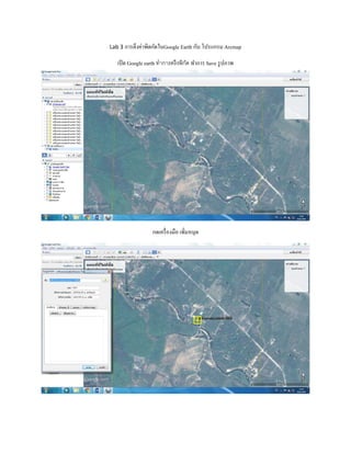
- 5. เปิดโปรแกรม Arc map เปิดภาพที่ทาการ Save มาจาก Google earth
เปิดเครื่องมือ Georeferencing เพื่อตึงพิกัด
- 8. คลิกขวาไฟล์ชื่อ Landuse_4000> Open Attribute Table> Add Field
ตั้งชื่อ LU_Name_TH(ชื่อภาษาไทย) > Typeเลือก Text > Field Properties 20 ตั้งชื่อ LU_Name_En(ชื่อภาษาอังกฤษ) > Type
เลือก Text > Field Properties 20 คานวณเป็น SqM > ตั้งชื่อ Area_SqM > Type เลือก Double > Field Properties > Precision = 2
และ Scale = 2 คานวรเป็นไร่ > ตั้งชื่อ Area_RAI > Type เลือก Double > Field Properties > Precision = 2 และ Scale = 2
- 15. Export เลือก All features > Use the same coordinate system as เลือก the data frame > Output feature class เลือกโฟลเดอร์ที่
จัดเก็บ กด save > กด ok
- 16. เปิดไฟล์ที่ทาการ Export > ไปที่แถบเครื่องมือ ToolBox > Layer To KML > Layer เลือกไฟล์ที่ทาการ Export > Output File ตั้ง
ชื่อเลือกโฟลเดอร์ที่จัดเก็บ > Layer Output Scale = 2000 > กด OK