INPUT2012 - Logos Loci - Yet another strategic planning Tool

The land use planning (which in this paper we call “LUPlanning”) is a complex matter that needs of clearness and standardize methods. This work proposes an effective tool for strategic planning, which provides the use of informatic systems to aid the decision makers and insiders of public body that are not professionals. The use of informatics makes easier and real time the public participation, an important critical point of planning, often difficult to implement for scepticism and in many town hard to really carry out, due to inadequate means. The aim of the proposed tool is to furnish a way to simplification of LUPlanning process and decision, using available and cheap hardware and software solutions. Computerization is not just a fad, but is almost inevitable evolution of management systems, so make it the most for the municipality means facilitating the work of technicians and insiders and the active involvement of citizens, for a more effective, rational and strategic land planning.

Recommandé
Contenu connexe
En vedette
En vedette (8)
Plus de City Planner
Plus de City Planner (20)
Dernier
Dernier (20)
INPUT2012 - Logos Loci - Yet another strategic planning Tool
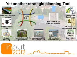
- 1. Yet another strategic planning Tool maps environmental Tutorial GIS analysis OpenSource Tool for Strategic Land Use Planning Remote sensing db design UAV environmental data Urban Investigation analysis development PHP 3D simulation Smart cities Planning geographical WebAPP/WebGIS land and buildings
- 2. Yet another strategic planning Tool Teory of Urban Planning GIS TOOL OF STRATEGIC PUBLIC LandUse PARTICIPATION PLANNING WEB Geo DataBase GPS
- 3. Yet another strategic planning Tool ... Mayor 3.0 SMyLA ... SMART CITY ...
- 4. Yet another strategic planning Tool CMS Wikipedia Content Management System Real local associations ERP Open Enterprise Resource Planning Social Streets Network Map GIS Community map geographic information system WIkitude Virtual augmented reality Mobile Facbook, Twitter Google+ FixMy APP Street GeoBlog
- 5. Yet another strategic planning Tool PHP Open Postgres Layers SMyLA PostGis QGis/gvSIG
- 6. Yet another strategic planning Tool SimMyLocalAround (SMyLA) ● Sim(ulation) we took from the popular game Sim City, which is the reference tool, hosting the entire idea; ● My represents the social media logic,more generally, all of the applications hosted by the Web 2.0, that are customizable and suitable for everyone; ● Local is identified with the territory and its projection on a geographical database by GIS; ● Around means all that surrounds us, not only physically, but also what interests us, what we like to see in certain situations and in certain time of the day, during the study, at work and in leisure, in a few words, our needs.
- 7. Yet another strategic planning Tool
- 8. Yet another strategic planning Tool
- 9. Yet another strategic planning Tool /home/pjh/Scrivania/ok/Schermata-00.png
- 10. Yet another strategic planning Tool Open Open Data Source Open Government
- 11. Drone technology Range of flyght: 0-200m GPS control Load weight 2,5kg FPV First Person View 3DR Quad Frame RCTimer 880kv motors RCTimer 40amp ESC's 12x4.5 Carbon/Nylon Blades APM 2.0 GoPro HD Hero 2 or Reflex or Camera A lot of sensor can mount Custom camera mount Arduino Ardupilot Time of light max 30min Instant delivery OPEN SOURCE HAND MADE
- 12. Drone technology + GIS
- 13. Drone technology + GIS
- 14. what can be achieved by a single photo? Panoramical photo Monitoring sites Systems verification Monitoring vegetation Vehicles control Social Advertising
- 15. Yet another strategic planning Tool via Sante Duzioni 14 - 22063 Cantù (CO) Tel. +39 329 2211978 Fax. 031 40 39 81 94 Email: segreteria@logosloci.com Responsabile: Luca Costenaro