
Recommandé
Contenu connexe
Tendances
Tendances (20)
En vedette
En vedette (20)
Similaire à The Continent of Africa
Similaire à The Continent of Africa (20)
Dernier
Dernier (20)
The Continent of Africa
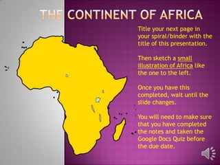
- 1. Title your next page in your spiral/binder with the title of this presentation. Then sketch a small illustration of Africa like the one to the left. Once you have this completed, wait until the slide changes. You will need to make sure that you have completed the notes and taken the Google Docs Quiz before the due date.
- 2. 2ndlargest continent (only Asia is larger) Covers over 11,000,000 square miles 23% of the world’s total land area 3 times larger than the United States
- 3. The equator divides Africa in half 35° N 36° S
- 4. Northern Coast is on the Mediterranean Sea Western Coast is on the Atlantic Ocean Eastern Coast is on the Red Sea, Arabian Sea and Indian Ocean Red Sea Mediterranean Sea Arabian Sea Atlantic Ocean Indian Ocean
- 5. A small land border joins Egypt and Israel Several islands are located around the coasts Madagascar is the largest, off the southeast coast Isthmus of Suez Madagascar
- 6. The Sahara is the world’s largest desert and covers 3,500,000 square miles ¼ of the continent Divides the continent into Northern and Southern Regions Sahara Desert Kalahari Desert
- 7. Africa has two major rivers Nile River Congo River Lake Victoria is the Largest lake in Africa and Lake the 3rd largest in the Victoria World.
- 8. The highest point is Mount Kilimanjaro 19,341 feet above sea level The lowest point is Lake Assal 502 feet below sea level
- 9. VictoriaFalls world’s most spectacular waterfalls. Named for Queen Victoria of England by David Livingstone, a Scottish explorer.
Notes de l'éditeur
- Draw a quick sketch of what the continent of Africa looks like. Don’t forget to add the island of Madagascar. It doesn’t have to be perfect!