SlideShare une entreprise Scribd logo
1  sur  94
ENVIROMENTAL PHYSICS
(i) Agriculture physics
- Influence of solar radiationon plant growth.
- Influence of wind, humidity, rainfall and air temperature onplant growth.
- Soil environmental component which influence plant growth.
(ii) Energy from the environment
Photovoltaic energy
Wind energy
Geothermal energy
Wave energy
(iii) Geophysics (Earthquakes)
Elastic reboundtheory
Types of seismic waves
Propagationof seismic waves
Seismology
(iv) Environmental pollution
Types of pollutant in the atmosphere
Transport mechanisms of atmospheric pollutant
Nuclear waste and their disposal
Effects of pollutiononvisibilityand optical properties of materials.
INTRODUCTION
Environmental physics is an interdisciplinarysubject that integrates the physics processesin
the followingdisciplines: the atmosphere, the biosphere, the hydrosphere, and the
geosphere.
Environmental physics canbe definedas the response of livingorganisms to their
environment within the frameworkof the physics of environmental processesand issues.
It is structures withinthe relationshipbetweenthe atmosphere, the oceans (hydrosphere),
land (lithosphere), soilsandvegetation (biosphere).
It embraces the followingthemes:
(i) Human environment and survival physics,
(ii) Built environment
(iii) Renewable energy
(iv) Remote sensing
(v) Weather, climate and climate change, and
(vi) Environmental health.
The environment maybe defined as the medium in which any entityfinds itself, For
example, for a cloudits environment may be the regionof the atmosphere inwhich it is
formed.
AGRICULTURE PHYSICS
Agriculture physics is concernedwithphysics environment in relationto plant growth.
(a) Influence of RadiationEnvironment onPlant Growth
Radiation environments. Refer to radiations present inthe atmosphere, commonly
comingfrom the sun.
Components ofsolar radiation
The main components of solar radiationare:
(i) Visible light
(ii) Infrared radiation, and
(iii) Ultraviolet radiation.
HEATING EFFECT OF SOLAR RADIATION ON PLANTS
Positive effect
An optimum amount of heat on plant favours the process of photosynthesis. This enables a
plant to make its own foodand hence provide its growth.
Negative effects
(i) Excessive solar radiation(ultraviolet light) onplants leads to bleaching of greenpigment
(chlorophyll). This lowers the amount of foodproducedby photosynthesis to plant and
hence a plant may die.
(ii) Excessive solar radiationonplants leads to excessive water loss inthe form of water
vapour commonlyon plant leaves (transpiration). Hence wilting(drying) of plants may
occur.
(b) Influence of Aerial Environment onPlant Growth
Aerial environments refer to the atmospheric conditionresultingfrom aseries of
processes occurringinthe atmosphere. These include air temperature, wind, humidity
and rainfall.
WIND EFFECT ON PLANT GROWTH
Positive effects
(a) Wind acts as pollinatingagent for some plants and hence favours plant productivity.
(b) Wind also favours evaporationof water from plant leaves and thus maintains water
balance for proper plant growth.
Negative effects
(a) Excessive wind on environments leads to plant breaking or cutting of tree
branches. This may lead to the death of plant.
(b) As the wind speedincreases further, cell andCuticular damage occurs, followedby death
of plant tissue, and a gnarled appearance becomes more apparent.
(c) At low wind speeds, the effect seems to be an increase intranspiration, which results in
water stress. This stress causesthe plant to adapt by decreasingleaf areaand internodes
length, while increasingroot growthand stem diameter.
(d) Strong wind may also cause shade off flowers;this lowers plant productivity.
Effect of Rainfall onPlant Growth
Positive effect
An optimum amount of rainfall on plants favours its growth. Water is a raw material for the
process of photosynthesis from whichplants obtain their foodand hence their growth.
Negative effect
Excessive rainfall leads to water logging in soil which in turn leads to root spoil and hence
the death of plant.
Effect of HumidityonPlant Growth
Positive effect
Favourable humidity on plants helpplants to conserve water for various activities and in
seeds helps the development of new leaves.
Negative effect
Low humidity results into a greater rate of transpirationand hence may result into plant
drying.
Effect of Air Temperature of Plant Growth
Positive effect
An Optimum temperature onplants enhances enzymic activities which in turn gives
favourable conditions for plant growth.
Negative effect
(a) High temperature denature enzymes commonlyfor photosynthesis andhence the death
of plant.
(b) Low temperature inactivates the plant growth enzymes, hence low growth rate.
Wind Belts
Wind belts are seasonal strongwind moving in a specifieddirectionina certainregionof
the earth.
The global wind belts are formedby two main factors:
(i) The unequal heating of the earth by sunlight and
(ii) The earth’s spin.
Here is asimple explanationofthe process
The unequal heating makes the tropical regions warmer than the Polar Regions. As a result,
there is generallyhigher pressure at the poles and lower at the equator. So the atmosphere
tries to sendthe coldair toward the equator at the surface and send warm air northward
toward the pole at higher levels.
Unfortunately, the spin of the earth prevents this from beinga direct route, and the flow in
the atmosphere breaks into three zones betweenthe equator and eachpole.
These form the six global wind belts: 3 in the NorthernHemisphere (NH) and3 in the
Southern(SH). They are generallyknown as:
(1) The Trade winds, which blow from the northeast (NH) and southeast (SH), are, found in
the sub tropic regions from about 30 degrees latitude to the equator.
(2) The Prevailing Westerlies(SW inNH in SH) which blow in the middle latitudes.
(3) The Polar Easterlies whichblow from the east in the Polar Regions.
Effects of windbelts to plant
1. Wind belts because the loss of plant leaves and flowers hence lower plant productivity and
growth. Loss of leaves lowers the rate of photosynthesis.
2. Wind belts sometimescause plants to leanin directionof movingwing. This changes
their directionof growth
3. Trees are brokenby the strongwind.
(c) Soil Environment Components WhichInfluence Plant Growth
Soil is composedof bothrockparticles and organic matter (humus) – the remains of plants
and animals in various stages of decomposition. The humus serves as foodfor many living
organisms. Within the soil is a large populationof animals, plants. These break down the
humus into soluble substances that can be absorbedby the roots of large plants.
Components ofa soil
Soil iscomposedof:
( (a) Air, 25% by volume which supports life of soil organisms,
(b) Water, 25% which dissolves minerals so that are easilyabsorbed by plants,
(c) Organic matter (humus), 5% by volume,
(d) Inorganic matter (minerals), 45% byvolume,
(e) Biotic organisms, micro – organisms like earthworm, centipedes, millipede, bacteria
which decompose organic matter.
Types of soil
(i) Sandy soil
(ii) Silt soil,
(iii) Clay soil, and
(iv) Loamy soil (sand+ silt + clay soil mixture)
Water Movement inthe soil
Two forces primarilyaffect water movement through soils, (a) gravity and (b) capillary
action.
Capillary actionrefers to the attractionof water into soil pores – an attractionwhich makes
water move in soil. Capillaryactioninvolves two types of attraction – adhesionand
cohesion.
Adhesion is the attractionof water to solidsurfaces.
Cohesionis the attractionof water to itself.
Speed of water in a particular soil type depends on:
(i) How much water is in the soil, and
(ii) Porosityof the soil.
The movement of water in the solidis mainly due to gravity. The porositygives a measure
of how much water the soil canhold and the rate at which water flows through the
soil. Large pore spaces give a faster rate and vice versa.
An experiment to studywater movement insoil
An experiment to demonstrate the rate of flowof water in the soil is done using a glass tube
and sand type filledinit. Water is poured into the tube and the time taken for water to reach
the bottom of the tube in notes.
Unsaturatedsoil Saturated soil
Soil type Water speed Soil type Water speed
Sandy Fastest Sand Slowest
Loamy Moderate Loamy Moderate
Clay Slowest Clay Highest
i. Sand soil have large pore spaces thus allows water to travel downwards through it at a
fastest rate.
ii. Claysoil canhold water as has very fine pore spaces.
iii. Loamysoil allows water movement at a medium rate.
Heat transfer inthe soil
Withinthe soil heat is transferredby a conductionprocess. Since soilis poor conductorof
heat most of the heat from the atmosphere appears at the surface of the earth.
An optimum soil temperature favours plants growth but a high temperature can leadto the
rottingof plant roots.
(d) Techniques for the Improvement ofthe Plant Environment
Plant environment can be improved by using wind breaks, shading and mulching.
Shading
Shading is the process of obstructingplants from excessive solar radiation.
Positive Impacts of Shading
1. Prevents excessive loss of water by plants through transpiration. This enhances plant
productivity.
2. Preserve moisture inthe soil and hence water supply to plant.
Mulching
Mulching is the process of coveringthe soil bydry leaves, grasses and or papers.
Benefits (Advantages) ofMulching
1. Improve soil moisture. Bare soil is exposedto heat, wind and compactionloseswater
through evaporation and is less able to absorbirrigationor rainfall. Using mulches, the
soil has greater water retention, reducedevaporation, and reducedweeds. Mulch can also
protect trees andshrubs from drought stress andcoldinjury
2. Reduce soil erosionandcompaction. Mulches protect soils from wind water, traffic
induced erosionandcompactionthat directlycontributeto root stress andpoor plant
health.
3. Maintenance ofoptimal soiltemperatures. Mulches have shown to lower soil
temperatures insummer months. Extreme temperatures cankill fine plant roots which
can cause stress androot rot. Mulches protect soils from extremetemperatures, either
coldor hot.
4. Increase soil nutrition. Mulches withrelativelyhigh nitrogencontent oftenresultin
higher yields, but low nitrogenmulches, suchas straw, sawdust and bark, can also
increase soil fertilityandplant nutrition.
5. Reductionofsalt and pesticidecontamination. In arid landscapes, evaporating water
leaves behind salt crusts. Because mulches reduce evaporation, water is left inthe soil
and salts are diluted. Organic mulches can actively accelerate soildesalinizationandhelp
degrade pesticides andother contaminants.
6. Improve plant establishment andgrowth. Mulches are usedto enhance the
establishment of many woody and herbaceous species. Mulches improve seed
germinationand seedsurvival, enhance root establishment, transplant survival, and
increase plant performance.
7. Reductionofdisease. Mulches will reduce the splashing of rain or irrigationwater,
which can carry spores of disease organisms to stems andleaves of plants. Populations
of beneficial microbesthat reduce soil pathogens canbe increasedwith
mulches. Mulches can combat disease organisms directlyas well.
8. ReductionofWeeds. Using mulches for weed control is highlyeffective. Mulches can
reduce seedgerminationof many weed species andreduce light, which stresses existing
weeds.
9. Reduce pesticideuse. Mulches reduce weeds, plant stress, andsusceptibilityto pests and
pathogens which translates to reduced use of herbicides, insecticides, and fungicides.
MulchProblems(disadvantages ofmulching)
1. i. Acidification. Some types of mulches canincrease soil acidity.
2. ii. Disease. Many mulches made from diseasedplant materials canbe compostedor treated
at temperatures that kill pathogens that can be transmittedto healthy plants.
3. iii.Pests. Many organic mulches, especiallywood – based mulches, have the reputationas
being “pest magnets”.
4. iv. Weed contamination. Improperlytreatedcropresidues andcomposts as well as bark
mulches are oftencarriers of weedseed. Mulchmust be deepenough to suppress weeds and
promote healthysoils and plants. Weedcontrol and enhanced plant performance are directly
linked to mulch depth.
v. Wind Breaks
Wind breaks are long rootedstrongplants (trees) that are used to obstruct the path of wind
or to slow down the wind.
Windbreaks provide many benefits to soil, water, plants, animals and man. They are an
important part of the modernday agricultural landscape. Windbreaks come inmany
different sizes andshapes to serve many different conservationpurposes.
In agriculture, wind breaks protect small growingplants from strongblowing wind
Advantages of Windbreaks to Plant Environment
1. i. Control soil erosion. Windbreaks prevent wind erosionfrom causingloss of soil
productivity. This eliminates plant roots stresses andthus favours plant growth condition.
2. ii. Increase plant yield. Windbreakresearchsubstantiates that fieldwindbreaks improve
cropyields which offsetsthe loss of productionfrom the landtaken out of cultivation.
3. Pesticide sprays. Windbreaks controlpesticide spraydrift and provide buffers to delineate
propertylines and protect neighbors.
EXAMPLES: SET A
Example 01
(a) What is agriculture physics? (02 marks)
(b) What are the components of a soil?How do they support the life of a plant? (06 marks)
(c) Explain brieflyhow soil temperature affectsplant growth. (02 marks)
Example 02
(a) What do you understand by the word environmental physics? (01 marks)
(b) Explain how the followingclimatic factors influenceplant growth: air temperature,
humidity, rainfall and wind. (06 marks)
(c) What are wind belts? Explain the effect of wind belts onplant productivity. (03 marks)
Example 03
(a) What is mulching? (02 marks)
(b) Give two advantages and two disadvantages of mulching. (04 marks)
(c) Discuss the heatingeffect of solar radiationto plant growth. (04 marks)
Example 04
(a) Explain two factors that primarilyaffect water movement in the soil (03 marks)
(b) Explain the soil environment that favours high cropyield (04 marks)
(c) What is shading and what is its purpose? (03 marks)
Example 05
(a) (i) Mentionthe components of solar radiation.
(ii) How do those components affect plant growth? (04½ marks)
(b) What are wind breaks? (02 marks)
(c) What are the advantages of wind breaks to plant environment? (03½ marks)
ENERGY FROM THE ENVIRONMENT
ENERGY
Energy is defined as the capacity to do work Or is definedas abilityto do work.
Energy is measuredin Joules (symbolJ)
Types of energy accordingto their usefulness
(i) High grade energy
(ii) Low grade energy
i. Highgrade energy is the energythat is easilytransformedinto other forms of energyand
is more suitable for doing works.
Examples are chemical and electrical energy.
ii. Low grade energy is the one that is not easilytransformedinto anything else.
Examples are the kinetic energyof molecules due to their randomness and the potential
energy due to the forces betweenmolecules.
ENERGY SOURCES
There are two types of energy sources, namely:
(i) Primaryenergy sources,
(ii) Secondaryenergysources.
i. Primaryenergysources
Primaryenergysources are sourcesof energythat are usedin the form in which they occur
naturally.
Primaryenergysources fall into two groups:
(a) Finite energysources,
(b) Renewable sources.
a. Finite energysources are those energysources that last after a number of years when
exploited.
Examples are coal, oil, natural gas, and nuclear fuels.
b. Renewable energysources: these cannot be exhausted. Examples are solar energy,
biofuels, hydroelectricpower, wind power, wave power, tidal and geothermal power, wind
power, wave power, tidal and geothermal power.
ii. Secondaryenergysources
Secondary energysources are usedin the non – natural form.
SOLAR ENERGY
Nature of solar energy
The sun’s energy is produced by thermonuclear fusion.
Not all of the solar radiationarriving at the edge of the Earth’s atmosphere reaches the
Earth’s surface.
About 30% is reflectedbackinto space by atmospheric dusts and by the polar ice caps.
About 47% is absorbedduring the day by the land and sea and becomes internal energy(i.e.
heats the Earth). At night this is radiated back into space as infrared.
23% causes evaporationfrom the oceans and sea to form water vapour. This results into rain
and hence hydroelectric power.
-0.2% causes convectioncurrentsinthe air, creatingwind power which in turn causes wave
power.
-0.02% is absorbedby plants during photosynthesis and is storedinthem as chemical
energy. Plants are sources of biofuels
Solar constant
Solar constant is defined as the solar energy falling per secondon a square meter placed
normal to the sun’s rays at the edge of the Earth’s atmosphere, when the Earth is at mean
distance from the sun.
Its value is about 1.35 kWm2
The amount of solar radiationreceivedat any point on the earth’s surface depends on:
(i) The geographical location,
(ii) The season, (summer or winter)
(iii) The time of the day, the lower the sun is in the sky the greater is the atmospheric
absorption.
(iv) The altitude; the greater the height above sea level the less is the absorptionby the
atmosphere, clouds and pollution
PHOTOVOLTAIC DEVICES (SOLAR CELLS)
A solar cell (PV, cells) is aPN junctiondevice which converts solar energydirectlyinto
electrical energy.
How it Works
PV cells are made of at least two layers of semiconductor material. One layer has a positive
charge (p – type material), the other negative (n-type material). When light enters the cell,
some of the photons from the light are absorbed by the semiconductoratoms, freeing
electrons from the cell’s negative layer to flow through an external circuit and back into the
positive layer. This flowof electrons produces electriccurrent.
Uses of the solar cell
1. (i)Are usedto power electronics insatellite andspace vehicles.
2. (ii)Are usedas power supply to some calculators.
3. (iii)Are usedto generate electricityfor home, office andindustrial uses.
Series arrangement ofsolar cells
Solar panel (module) is asealed, weatherproof package containing a number of
interconnectedsolar cells so as to increase utilityof asolar cell.
When two modules are wired together inseries, their voltage is doubled while the current
stays constant.
When two modules are wired in parallel, their current is doubledwhile the voltage stays
constant.
To achieve the desiredvoltage and current, modules are wired in series and parallel into what
is calleda PV array.
The flexibilityof the modular PV system allows designers to create solar power systems that
can meet a wide variety of electrical needs, no matter how large or small.
Efficiencyofa photovoltaicsystem
The output power of a solar cell depends on:
(i) The amount of light energy from the sun falling on a solar panel (the intensityof
light).
(ii) The orientation of the solar panel. More electricityis producedif light falls
perpendicular to panels.
(iii) The surface areaof the panel. Large area collects more solar energyand hence
greater electricity.
The best designed solar cell can generate240Wm-2 in brightsun lightat an efficiency of
about 24%.
Advantages of photovoltaic systems
1. Solar cells canproduce electricitywithout noise or air pollution.
2. A photovoltaic system requires no fuels to purchase.
3. Panels of photovoltaic cells are usedfor small – scale electricitygenerationinremote
areas where there is sufficient sun.
4. Net metering: This has the potential to help shave peak loads, which generallycoincide
with maximum PV power production.
5. The electricityfrom aPV system is controllable.
Disadvantages ofphotovoltaicsystems
1. They require an inverter to convert the d.c output into a. c for transmission.
2. They produce electricityonlywhen there is sunlight. Hence theyneed backup batteries to
provide energy storage.
3. Suitable in areas which receives enoughsunlight.
4. Photovoltaic large scale power generationis cost effective. This is due to large surface
area of cells requiredfor generatinghighpower outputs and the need to convert d.c to a.c
for transmission.
5. Comparedto other energysources, PVsystems are an expensive way to generate
electricity.
6. The available solar resourcedepends ontwo variables: The latitude at which the array is
locatedand the average cloudcover.
WIND ENERGY
Winds are due to conventional currents inthe air caused by uneven heating in the earth’s
surface by the sun.
Wind energy is extractedby a device called windturbine.
Wind speed increases withthe height; it is greatest in hillyareas. It is also greater over the
seaand coastal areas where there is less surface drag.
Wind turbines are also called aerogenerator or windmills (oldname)
Types of windturbines
There are two types of wind turbines;
(i) Horizontal axis wind turbines (HAWT)
(ii) Vertical axis wind turbines (VAWT)
Horizontal axis windturbine(HAWT)
HAWT has two or more longvertical blades rotatingabout a horizontal axis. Modern
HAWTs usually feature rotors that resemble aircraftpropellers, whichoperate onsimilar
aerodynamic principles, i.e. the air flow over the airfoil shaped blades creates aliftingforce
that turns the rotor. The nacelle of a HAWT houses a gearboxand generator (alternator).
Advantage of HAWT
1. HAWTS can be placed on towers to take advantage of higher winds farther from the
ground.
Disadvantages ofHAWT
1. The alternator (generator) is pacedat the topof the supportingtower.
2. Can produce power in a particular wind direction.
Vertical axis windturbine (VAWT)
In vertical axis, the blades are long and vertical and can accept wind in any direction. The
blades are propelledby the drag force onthe blades as the wind flows.
Advantages of VAWT
1. It can harness wind from any direction
2. Typically operate closer to the ground, which has the advantage of allowing placement of
heavy equipment, like the generator and gearbox, near ground level rather than in the nacelle.
Disadvantages ofVAWT
1. Winds are lower near ground level, so for the same wind and capture area, less power will be
producedcomparedto HAWT.
2. Time varying power output due to variation of power during a single rotationof the blade.
3. The need for guy wires to support the tower.
4. Darrieus VAWTS are not self startinglike HAWTS. (More colorful picture andvideos
during lecture)
Power ofaWind Turbine
Consider a wind turbine with blades of length, r (area A), the wind speedis v and the air
densityis ρ. Assuming that the air speedis reducedto zero by the blades.
Kinetic energyof the wind, K.E =
Kinetic energyper unit volume
K.E per volume = ÷ volume =
The blades sweeps out an area A in one turn, so the volume of air passing in one secondis
Av.
Kinetic energyper second
= K.E per unit volume x volume per second
K.E per second= =
The available windpowerisP =
Extractable power
The power extractedby the rotatingblades is much less than the available wind power. This
is because:
(i) The velocityof the wind is not reducedto zero at the blades
(ii) Losses due to frictionat the turbine and alternator
(iii) Due to losses inboththe gear train and generator.
The power actually capturedby the wind turbine rotor, PR, is some fractionof the available
power, definedby the coefficient of performance, Cp, which is essentiallyatype of power
conversionefficiency:
=
The extractable power (electrical power output) is given by
Where ns and nb are efficiencies (power output over power input) for the generator and the
gearbox.
Variations ofpower withwindspeed
The power curve for a wind turbine shows this net power output as a functionof wind speed.
i. Cut inwindspeed: This is the lowest speedat which the wind turbine will start
generating power.
Typical cut – in wind speeds are 3 to 5 m/s.
ii. Nominal windspeed: This is the lowest speedat which the wind turbine reaches its
nominal power output.
Above this speed, higher power outputs are possible, but the rotor is controlledto maintaina
constant power to limit loads and stresses onthe blades.
iii. Cut – out windspeed: This is the highest wind speedwhich the turbine will operate at.
Above this speed, the turbine is stoppedto prevent damage to the blades.
Advantages of Wind Energy
1. Wind Energy is an inexhaustible source of energyand is virtually a limitless resource.
2. Energy is generatedwithout polluting environment
3. This source of energyhas tremendous potential to generate energyonlarge scale.
4. Like solar energyand hydropower, wind power taps a natural physical resource,
5. Windmill generators don’t emit any emissions that canlead to acid rain or greenhouse
effect.
6. Wind Energy can be useddirectly as mechanical energy
7. In remote areas, wind turbines can be usedas great resource to generateenergy
8. In combinationwith Solar Energy they can be used to provide reliable as well as steady
supply of electricity.
9. Land around wind turbines can be used for other uses, e.g. Farming.
Disadvantages ofWind Energy
1. Wind energy requires expensive storage duringpeak productiontime.
2. It is unreliable energy source as winds are uncertainand unpredictable.
3. There is visual and aesthetic impact onregion
4. Requires large openareas for settingup wind farms.
5. Noise pollutionproblem is usuallyassociatedwithwind mills.
6. Wind energycan be harnessedonly in those areas where wind is strongenough and
weather is windy for most parts of the year.
7. Usually places, where wind power set-upis situated, are away from the places where
demand of electricityis there. Transmissionfrom suchplaces increasescostof
electricity.
8. The average efficiencyof wind turbine is very less as comparedto fossil fuel power
plants. We might require many wind turbines to produce similar impact.
9. It can be a threat to wildlife. Birds do get killedor injured when they flyinto turbines.
10. Maintenance cost of wind turbines is high as they have mechanical parts which undergo
wear and tear over the time.
NB: Even though there are advantages of wind energy, the limitations make it extremely
difficult for it to be harnessedand prove to be a setback
GEOTHERMAL ENERGY
Geothermal energyis the energy from nuclear energychanges deep in the earth, which
produces hot dry rock.
Geothermal energyoriginates from the heat retainedwithin the Earth since the original
formationof the planet, from radioactive decayof minerals, and from solar energyabsorbed
at the surface.
Harnessing Geothermal Energy
Most high temperature geothermal heat is harvested in regions closeto tectonicplate
boundaries where volcanic activity rises closeto the surface of the Earth. In these areas,
ground and groundwater can be found with temperatures higher than the target temperature
of the application.
Geothermal energyis extractedby using two methods:
(i) A heat pump system
(ii) Hot dry rockconversion
The heat pump system
Hot aquifers are layers of permeable (porous) rocksuchas sandstone or limestone at a depth
of 2 – 3 km which contains hot water at temperatures of 60 – 1000C.
A shaft is drilledto aquifer and the hot water pumped up it to the surface where it is usedfor
district space and water heating schemes or to generate electricity. A secondshaft may be
drilledto returnthe cool water to the rock.
The hot dry rockconversion
These are impermeable hot dry rocks foundat depth of 5 – 6 km, have temperature of 2000C
or more.
Two shafts are drilledand terminate at different levels inthe hot rockabout 300 m
apart. The rocks near the end are fracturedby explosionor bymethods to reduce the
resistance
to the flow of coldwater which is pumped under very high pressure (300atm) down the
injectionshaft and emerges as steam from the top of the shallower shaft.
Uses of geothermal energy
Geothermal energycan be used for electricityproduction, for direct use purposes, and for
home heating efficiency(throughgeothermal heat pumps).
Advantages of geothermal energy
1. Geothermal power plants provide steady and predictable base load power.
2. New geothermal power plants currentlygenerate electricityat low cost.
3. Responsiblymanaged geothermal resources candeliver energyand provide power for
decades.
4. Geothermal power plants are reliable, capable of operatingabout 98 percent of the time.
5. Power plants are small, require no fuel purchase and are compatible with agricultural land
uses.
6. Geothermal plants produce a small amount of pollutant emissions comparedto traditional
fossil fuel power plants.
Disadvantages ofgeothermal energy
1. Many of the best potential resources are locatedinremote or rural areas, often
of federal or state lands
2. Although costs have decreasedinrecent years, explorationand drillingfor power
productionremainexpensive
3. Using the best geothermal resources forelectricityproductionmayrequire an
expansion or upgrade of the transmissionsystem.
4. The productivity of geothermal wells may decline over time. As a result, it is crucial
that
developers manage the geothermal resourcesefficiently.
WAVE ENERGY
Wave energy is the energy extractedfrom the oceansurface wave. Energy that comes from
the waves in the oceansounds like a boundless, harmless supply.
Machinery able to exploit wave power is generallyknown as a wave energyconverter
(WEC)
Wave power
Waves in the sea have kinetic energyand gravitational potential energyas the rise and fall.
Consider a sine wave of wave length λ spread over a width d the amplitude of the wave is a
and the time periodis T.
The power in a wave come from the change in potential energyof the water as it rotates on
the circuit paths beneath the surface. It can be shown that the power carriedforwardby a
wave is given by:
Wave EnergyFlux
The mean transport rate of the wave energythrough a vertical plane of unit width , parallel to
a wave crest, is called wave energyflux.
From above,
Harvesting wave energy
There are two type of system:
1. i. Offshore systems indeepwater more than 141 feet deep. The Salter duckmethod.
(a) Pumps that use bobbing motionof waves.
(b) Hoses connectedto floats onsurface of waves. As float rises and falls , the hose
stretches andrelaxes, pressurizingthe water which then rotates aturbine
2. ii. Onshore systems are built along shorelines andharvest energyfrom braking waves.
(a)Oscillatingwater columns are of concrete or steel andhave an openingto the sea below
the waterline. It uses the water to pressurize an air column that is drawn through the turbine
as waves recede.
(b)A Tapchan is a taperedwater system insea cliffs that forces waves through narrow
channels and the water that spills over the walls is fedthrough a turbine.
(c)A Pendulor device is a rectangular box with a hinged flap over one side that is opento the
sea.Waves cause the flap to swing back and forthand this powers a hydraulic pump and
generator.
Advantages of Wave energy
1. Renewable: It will never run out.
2. Environment friendly: Creatingpower from waves creates no harmful byproducts such as
gas, waste, and pollution.
3. Abundant and widely available: Another benefit to using this energy is its nearest to places
that can use it.
4. Variety of ways to harness: Current gathering methodrange from installedpower plant
with hydro turbine to seafaring vessels equipped with massive structures that are laid into the
seato gather the wave energy.
5. Easily predictable: The biggest advantage of wave power as against most of the other
alternative energysource is that it is easilypredictable and can be usedto calculate the
amount that it can produce.
6. Less dependencyon foreignoil cost.
7. Non damage to land.
Disadvantages ofwave energy
1. Suitable to certainlocations: The biggest disadvantage to gettingyour energy from the
wave is location. Onlypower plants and town near the oceanwill benefit direct from it.
2. Effect onmarine ecosystem: Large machine have to be put near and in the water gather
energy from waves .These machines disturb the seafloor, changes the habitat of near-
shore creatures (like crabs and starfish) and create noise that disturbthe sealife around
them.
3. Wavelength: Wave power is highly dependent on wavelength i.e. wave speed, wave
length, and wavelength and water density.
4. Weak performance inRough Weather: The performance of wave power drops
significantlyduring rough weather.
5. Noise and Visual pollution: Wave energygenerators may be unpleasant for some
who live close to coastal regions. They looklike large machines working in the
middle of the oceanand destroythe beauty of the ocean. They also generate noise
pollutionbut the noise is oftencoveredby the noise of waves which is much more
than that of wave generators.
6. Difficult to convert wave motioninto electricityefficiently.
7. Difficult to designequipment that can withstand storm damage and saltwater
corrosion.
8. Total cost of electricityis not competitive withother energysources.
9. Pollutionfrom hydraulic fluids and oils from electrical components.
TIDAL ENERGY
Tidal Power is the power of electricitygenerationachievedby capturing the energy
containedin moving water mass due to tides.
Two types of tidal energy can be extracted: Kinetic energy of currents betweenebbingand
surging tides and potential energy from the differenceinheight between high and low tides.
Causes of Tides
Tides are causedby the gravitational pull of the moon, and to a lesser extent the sun, on the
oceans. There is a high tide places near the moonand also opposite onthe far side.
i. High(spring) tide: Occurs whenthere is full moon. The moon, sun and earth are in line
the moonbeing between earthand sun. The pulls of the moonand sun reinforceto have
extrahigh tides.
ii. Lowest (neap) tide: Occurswhen there is half moonand the sun and moonpulls are at
right angles to eachother.
iii. Harnessing Tidal Energy
Tidal energy can be harnessedby building a barrage (barrier), containingwater turbines and
sluice gates, across the mouthof river. Large gates are openedduring the incoming (flood)
tide, allowing the water to pass until high tides, when they are closed.
On the outgoing tide, when a sufficient headof water has built up, small gates are opened,
lettingthe potential energyof the trapped water drive the turbines and generate electricity.
Advantages of Tidal Energy
1. Decrease relianceoncoal driven electricityso less CO2 emissions.
2. Changing technologyallowingquicker constructionof turbines, whichin turn increases
likelihoodof investment with a shorter return.
3. Once constructedvery little costto runand maintain.
4. Tidal energyis renewable and sustainable.
Disadvantages ofTidal Energy
1. Intermittent energyproductionbasedaround tides creates unreliable energysource.
2. High constructioncosts
3. Barrages can disrupt natural migratoryroutes for marine animals.
4. Barrages can disrupt normal boating pathways.
5. Turbines can kill up to 15% of fishin area, although technologyhas advanced to the point
that the turbines are moving slow enough not to kill as many.
Tidal Power
If the tidal height (level) is h and the estuaryarea is A, then the mass of water trapped being
the barrier is and the centre of gravity is h/2 above the low tide level.
The maximum energyper tide is therefore
Potential Energyof tide =
Averaged over a tidal periodof T (approx. 12 hours a day), this gives a mean power available
of.
Average tidal power =
Note that the efficiencyof the turbines (generator) will determine howmuch of this tidal
power will be harnessed.
EXAMPLES: SET B
Example 01
The power output p of a windmill can be expressedas where A is the area swept
out by the windmill blades (sails), is the densityof air, v is the wind speedand k is a
dimensionless constant
(a) Show that the units onboth sides of this expressionare the same
(b) Sketch a graph to show how the power increases withwind speedas v rises from zero to
15ms-1
Solution
(a) Units on L.H.S = Nms-1
Unit on R.H.S. = m2 (kgm-3) x (ms-1)3
= (kgms-2) ms-1=Nms-1
(b) Variation of power with speed
0
Example 02
The radiation receivedfrom the sun at the earth’s surface ina certaincountryis about 600
Wm-2 averaged over 8 hours in the absence of cloud.
(a) What area of solar panel would be neededto replace apower stationof 2.0 GW output, if
the solar panels used couldconvert solar radiationto electrical energyat an efficiencyof
20%
(b) What percentage is this area of the total of the country(which is about 3 x 10¹¹m2)?
(c) If the total power stationcapacityis about 140 GW, what percentage of the surface of the
countrywould be coveredby solar panels if all the power stations were replaced?
Solution
(a) Output of a solar panel
(b) Percentage areato the country
(c) Area of solar panels required
Percentage areato the country
Example 03
(a) What are aerogenerators?
(b) Estimate the maximum power available from 10m2 of solar panels and calculate the
volume of water per secondwhich must pass through if the inlet and outlet temperatures
are 200C and 700C. Assume the water carries away energy at the same rate as the
maximum power available. The specific heat capacityof water is 4200 Jkg-1 and solar
constant is 1.4 kWm-2.
Solution
(a) Aerogenerators are devices that convert the kinetic energyof wind into electrical
energy. E.g. windmill.
(b) Maximum power available from solar panel
Volume of water per secondusedis given by
1400 =
Example 04
A coal – fired power station has an output of 100mW. Given that its efficiency is 45%, how
much coal must be suppliedeach day? Assume 1 tonne of coal gives 3 x 10¹⁰ of energy.
Solution
Input power of the stationis given by
Total input energyin a day is
The amount of coal requiredis
Example 05
Calculate the energy required transport1000 tones of oil along a 100km pipeline; given that
0.05 kW hours of energy is used to shift each tone of oil along each km of pipeline. Given
that 1 tonne of oil releases 4.2 x 10¹⁰ J if burned, what percentage of the total energy
available from 1000 tonnes of oil is used to shift the oil along the pipeline? (Ans: 18GJ,
0.043%)
Example 06
A hydroelectric power station has efficiency of 25%. The water driving the turbines falls
through a height of 300m before reaching the turbines. Calculate the volume of water that
must pass through the turbines each second to give a power output of 2mW. Assume the
densityof water is 1000kg-3.
Solution
Power of the falling water
But,
Example 07
The solar energy flux near the Earth is 1.4W m-2. A solar power station consists of concave
mirrors that focus sunlight onto a steam boiler. What must be the minimum mirror area to
given an output 1 mW, assuming 100% efficiency? Why in practice, should the mirror area
be greater?
Solution
Minimum mirror areais given by
The mirror area should be greater to achieve such a power output because part of the incident
energy is absorbedby the mirror.
Example 08
A solar panel attached to the roof of a house is used to heat water from 50C to 400C. If the
water flows through the panel at a rate of 0.012kgs-1 Calculate the heat gained per second by
the water. Assume the specific heat capacityof water is 4200Jkg-1K-1. (Ans. 1764 Q)
Example 09
An aerogenerator has a power output that is proportional to (wind speed) 2 and its efficiency
varies with wind speed. On a day when there is a steady wind of speed 9 ms-1, the power
output is 40kW operating at an efficiency of 20%. If the wind speed on next day is 13.5 ms-1
and the efficiencyincreases to 25% what is the new power output?
Solution
Power output α efficiency × (wind speed)2
Example 10
Estimate the energy released from a tidal power station if 100 km3 of water raised to height
of 1.5m by the tide behind a tidal barrier. What would be the mean power output of such a
stationif its efficiencyis 25% and there are two tides per day?
Solution
The tidal power is given by
Note that the centre of gravity of water mass is at the half height up.
Mean power output is
Example 11
An open boat of width 1.0 m has a total weight of 3000N.Used near a beach, it bobs up and
down through 0.5 m once every 5s. Calculate the losses of P.E. every time it drops from a
crest to athrough. Hence estimate the meanpower available per meter of beachwaves.
Solution
Loss in P.E. is given by
The mean power available per meter is 300 W
Example 12
(a) If energyis conserved, why is there energycrisis?
(b) Explain the terms high grade and low grade energyand give examples.
(c) Draw an energy flow diagram for a hydroelectric power station. Why does such a station
have a much greater efficiencythan a thermal power station?
Refer Advanced Physics byTom Duncan fiftheditionfor more problems onenergy.
GEOPHYSICS
Geophysics is the branch of physics which deals with the study of seismic waves and the
Earth’s magnetic and gravity fields and heat flow.
Because we cannot directly observe the Earth’s interior, geophysical methods allow us to
investigate the interior of the Earth by making measurements at the surface. Without
studying these things, we would know nothing of the Earth’s internal structure.
STRUCTURE OF THE EARTH
Major zones of the earth
The earth is divided into two major zones, namely;
(a) Outer zone, and
(b) Inner zone.
a) Outer zone: the earth’s outer zone consists of;
(i) The hydrosphere – water bodies,
(ii) The atmosphere – gaseous envelope
(iii) The biosphere – living organisms, plant and animals
b) Inner zone: the earth’s inner zone consists of;
(i) The crust – lithosphere
(ii) The mantle – mesosphere,
(iii) The core – barysphere
Atmosphere is the envelope of gases that surround the Earth (oxygen, nitrogen, carbon
dioxide, etc)
Hydrosphere is the water bodies filling the depressions in the Earth. Examples are rivers,
oceans, seas, oasis,
Lithosphere is the solidouter most part of the earth.
EARTH’S LAYERS
Layers definedby composition
Layers are defined by composition because of density sorting during an early period of
partial melting, Earth’s interiors not homogeneous.
 Crust – the comparatively thin outer skin that ranges from 3 kilometers at the oceanic ridges
to 70 kilometers insome mountainbelts. It makes up 1% of the Earth’s volume.
Continental crust (SIAL, Siliconand aluminium)
Average rockdensityabout 2.7 g/cm3
Its densityvaries between 2.0 to 2.8 g/cm3
Composedof siliconand aluminium
Floats higher on the mantle forming the land masses and mountains. It is 30 to 70 km
thick.
Oceanic crust (SIMA), siliconand magnesium)
Oceanic crust ranges from 3 to 15 km thick
Densityvary between3.0 to 3.1 g/cm3
Floats lower on the mantle formingthe oceanic basins. It is about 8 km thick.
 Mantle – a solid rocky (silica-rich) shell that extends to a depth of about 2900
kilometers. It makes up 83% of the Earth’s volume
The mantle can further be dived into:
(i) Upper layer of mantle (Asthenosphere)
(ii) Transitionlayer and,
(iii) Lower layer of mantle (Mesosphere)
Upper mantle is a rigidlayer of rockwith average density3.3kgm-3
Transitionlayer is the layer that separates upper and lower mantle.
Lower mantle plays an important role in tectonic plate movement which creates earthquakes
and volcanoes.
Its densityis about 5.7 kgm-3
Note:
The mantle rocks are saidto be in a plastic state.
The upper part of a mantle has a temperature of about 8700C. The temperature
increases downwards through the mantle to about 22000C near the core.
 Core - an iron – rich sphere having a radius of 3486 kilometers making up 16% of the
Earth’s volume
The core is divided into two parts:
(i) Outer core
(ii) Inner core
i. Outer core is a liquid of molten iron and nickel alloys. The Earth’s magnetic field is
generatedwithin the outer core due to convective. It is 2270 kilometersthick.
ii. Inner core is a solid iron and nickel alloys. The temperature within the inner core is
higher than the outer core but the inner core is solid, this is because higher pressure in this
regioncauses the meltingpoint to rise. It is a sphere of radius of 1216 kilometers.
Average densityis nearly 11 gcm-3and at Earth’s center.
Layers definedby physical properties
Lithosphere (sphere of rock)
Earth’s outermost layer
Consists of the crust and uppermost mantle
Relativelycook, rigid shell
Averages about 100 kilometers in thickness, but may be 250 kilometers or more thick
beneath the older portions of the continents
Asthenosphere (weaksphere partially molten)
Beneath the lithosphere, inthe upper mantle to a depth of about 660 kilometers
Small amount of melting in the upper portion mechanically detaches the lithosphere from
the layer below allowing the lithosphere to move independently of the asthenosphere i.e.
allows tectonic plate movement.
Mesosphere or lower mantle
Rigid layer betweenthe depths of 660 kilometersand 2900 kilometers
Earth’s major boundaries
Discontinuity is the name given to any surface that separates one layer from another layer of
the Earth.
The Moho (Mohorovicicdiscontinuity)
Discoveredin1909 by Andriaja Mohorovicic
Separates crustal materials (crust)from underlyingmantle.
Gutenberg discontinuity
 Discoveredin1914 byBeno Gutenberg
 Is the boundary between the outer and inner core.
The Earth’s Structure
TEMPERATURE INSIDE THE EARTH
Earth’s temperature gradually increases with an increase in depth at a rate known as the
geothermal gradient.
Temperature varies considerablyfrom place to place
Averages between about 200C and 300C per kilometer in the crust (rate of increase is much
less inthe mantle and core)
The rate of heat flow within the Earth depends on:
(i) The thermal conductivity of the rock,
(ii) Temperature gradient of the rock
Sources ofheat Energywithinthe Interiorofthe Earth
Major processesthat have contributedto Earth’s internal heat include:
1. Heat emitted by radioactive decay of isotopes of uranium (U), thorium (Th), and potassium
(K).
2. Heat releasedas ironcrystallizedto form the solidinner core.
3. Heat releasedbycollidingparticles duringthe formationof Earth.
4. Gravitational work done by the Earth due to its rotationthroughits own axis.
5. Electronmotioninthe core behaves like an electriccurrent.
Heat Lost by the Earth
Heat in the earth is transferredbythe process of;
(i) Convectionand
(ii) Conduction
In the solid inner core and in the Earth’s crust heat is transmitted by conduction
process. Rates of heat flowin the crust vary.
In the Mantle heat is transmittedby conductionprocess. Rates of heat flowin the crust vary.
In the Mantle heat is transmitted by convection process. There is not a large change in
temperature with depth in the mantle.
Mantle must have an effective methodof transmittingheat from the core outward.
Transfer of heat inthe Earth by mantle convection
Uses of the Mantle
1. The mantle transfers heat by convection from the earth’s crust to the out regions of the
earthand thus help it to regulate its temperature
2. The upper part of the mantle is molten, this allows tectonic plates movements.
EARTHQUAKES
An earthquake is a sudden motion or shaking of the earth caused by a sudden release of
energy that has accumulated within or along edges of the earth’s tectonic plates.
Earthquakes occur within the Earth’s crust along faults that suddenly release large amounts
of energy that have built up over long periods of time.
The shaking during an earthquake is causedby seismic waves.
Seismic waves are propagating vibrations that carry energy from the source of the shaking
(earthquake) outward in all directions.
Seismic waves are generated when rock within the crust breaks, producing a tremendous
amount of energy. The energy released moves out in all directions as waves, much like
ripples radiating outward when you drop a pebble in a pond.
CAUSES OF EARTHQUAKES (SEISMIC WAVES)
The main causes of the Earthquakes and so seismic waves are:
1. Movement of tectonic plate.
2. Volcanic activity.
3. Landslide and avalanches.
4. Rebound of the crust.
5. Human activities.
Movement oftectonic plate
The Earth’s crust is made up of segment (layers) called tectonic plates which are slowly
driftingin various directions. Tectonic plates maycreate a fault.
A boundary is a line where two tectonic plates meet.
A geologic fault is a fracture in the earth’s crust causing loss of cohesion and accompanied
by displacement alongthe fracture.
How an earthquake is formed
Tectonic plates grind past each other, rather than slide past each other smoothly. As the
plates move past each other they can become locked together due to friction. For some time,
they don’t move and strain energy builds up. Stresses builds between them until fractional
force holding the plates together give away. The plates move suddenly, releasing the energy
and then held again. This sudden jerkis what is felt as an earthquake.
Note
(a) The Earth’s crusts near tectonic plate edges are forced to bend, compress, and stretch due
to the internal forces withinthe earth, causing earthquakes.
(b) Nearly all earthquakes occur at plate boundaries.
Volcanic activity
Molten rock “magma” from the mantle is forced through a weak point in the Earth’s crust
creating a volcanic eruption. When magma reaches the Earth’s surface it is known as
“Lava”. Successive eruptions leads to the buildup of lava on the sides of the vent creating
the familiar “cone – shape” of a volcanoes
Earthquakes may be created by the violent explosions which occur if there are sudden
movements of the magma.
Landslides andavalanches
A landslide occurs when a large mass of land slips down a slope. An Avalanche occurs when
a large mass of snow pours down a mountain side. Both of these effects can start an
earthquake
Rebound of the crust
Elastic rebound theory state that "as tectonic plates move relative to each other, elastic
strain energy builds up along their edges in the rocks along fault planes". Since fault planes
are not usually very smooth, great amount of energy can be stored (if the rock is strong
enough) as movement is restricted due to interlock along the fault. When the shearing
stresses induced in the rocks on the fault planes exceed the shear strength of the rock, rupture
occurs.
It follows from this that if rocks along the fault are of a certain strength, the fault is a certain
length, and the plates are slipping past each other at a defined rate, it is possible to calculate
the amount of time it will take to build up enough elastic strain energy to cause an
earthquake and its probable magnitude.
When a fault breaks it release elastic strainenergyit stored, andhence earthquake.
Human activities
Human activities such as those caused by nuclear bombs can create earthquake, together with
mine actives.
EARTHQUAKE TERMS
Energy released by an earthquake moves outwards from the origin in the form of concentric
waves.
Focus (Hypocenter) is the point in the Earth where seismic waves originate.
Epicenter is the point onthe earth’s surface verticallyabove the focus.
Hypocentral distance is the distance betweenthe focus and the seismic detectionstation.
Epicentral distance is the distance betweenthe epicentral and the seismic station.
S = Seismic station
E = Epicenter
ES = Epicentral distance
TYPE OF SEISMIC WAVES
i. Seismic waves are elasticwaves that propagate within the earth.
There are two type of seismic waves:
1. ii. Bodywaves, spreadoutward from the focus inall directions.
2. iii. Surface waves (Long, L – waves) spread outward from the epicenter to the Earth’s
surface along the crust, similar to ripples on a pond. These waves can move rock particles in
a rolling motion that very few structures can withstand. These waves move slower than body
waves.
BODY WAVES
There are two types of Body Waves
(1) PrimaryP – wave and
(2) Secondary, S – waves
1. 1. Primary Wave (P – wave): Are longitudinal (compression) wave (travels in the same
directionthe waves move)
Characteristics ofP – waves
1. Are the fastest seismic waves (7 – 14 km/second). Arrives at recording station first, hence
the name primary means first.
2. Can pass through solid, gas and liquid, hence can pass through crust, mantle and the cores.
3. Are longitudinal compression waves. The rocks that transmit the P – waves are alternately
compressedand expanded.
VelocityofP – waves
The velocity of primary waves depends on the density, bulk modulus B and the shear
modulus
In solid, =
In liquid =
A fluid cannot support shear stresses hence
2. Secondary Wave (S – wave): Are transverse (shear) wave (travels perpendicular to the
wave movement).
Characteristics ofS – waves
1. i. Slower moving (3.5 – 7 km/second) hence are detectedafter primarywaves.
2. ii. Caused by a shearingmotion
3. iii. Cannot pass through a fluid (gas or liquid) because they are transverse. Hence are unable
to pass through the liquid outer core.
VelocityofS – waves
The velocityof shear waves depends on the density and the shear modulus
In solid, =
In liquid =
Note: Since the density and states of the earth layers varies, the speed of the seismic waves
also vary from layer to layer, the solid part showing greater speed and the liquid ones lower
speed.
Primarywave and secondarywave
Variationofspeedof body waves withdepth
SURFACE WAVES/LONG WAVES
Surfaces waves are producedwhen earthquake energy reaches the Earth’s surface.
These are the slowest moving waves, but are the most destructive for structures onearth
There are two types of L – Waves:
(i) Love long waves
(ii) Rayleighlong waves
i. Love Waves
Love waves are Transverse horizontal motion, perpendicular to the direction of propagation
and generallyparallel to the Earth’s surface.
They are formed by the interaction of S waves with Earth’s surface and shallow structure and
are dispersive waves. The speed at which a dispersive wave travels depends on the wave’s
period.
Characteristics ofLove Waves
1. i. Love waves are transverse and restrictedto horizontal movement (horizontallypolarized).
2. ii. The amplitude of ground vibration caused by a Love wave decrease with depth. The rate
of amplitude decrease withdepth also depends on the period/frequency.
3. iii. Loves wave are dispersive, i.e. wave velocity is dependent on frequency; low frequency
– higher velocity.
4. iv. Speed of love waves is between 2.0 and 4.4 km/s
5. v. Love waves travels within the earth’s crust only.
LOVE WAVE
RayleighWaves
Rayleigh waves are vertically polarized long waves. The slowest of all the seismic wave
types and in some ways the most complicated.
Characteristics ofRayleighWaves
1. Rayleigh waves are transverse and restrictedto vertical movements (verticallypolarized).
2. The amplitude of Rayleigh wave decreases with depth. The rate of amplitude decrease
with depth depends on the period/frequency
3. Rayleigh wave are dispersive, i.e. wave velocity dependent on frequency; low frequency
– high velocity
4. Speedof love waves is between 1.0 and 4.2 km/s slowest of all waves.
5. Travels within the earth’s crust only.
6. Depth of penetration of the Rayleigh waves depend frequency, with lower frequencies,
penetratinggreater depth.
PROPAGATION OF SEISMIC WAVES
Like all other types of waves, seismic waves may undergo,
(i) Reflection, (ii) Refraction, (iii) Dispersion, (iv) Diffraction, (v) Attenuation.
Seismic reflection:
Seismic waves bounce (reflect) rockboundaries of different rocktype (density).
Seismic refraction:
Waves change velocity and direct (refract) when they enter a medium of different density it
the one they just passed through.
Seismic Dispersion:
surface waves are dispersive which means that different periods travel at different
velocities. The effects of dispersion become more noticeable with increasing distance
because the long travel distance spreads the energyout (it disperses to energy).
SEISMIC WAVE PATHS
By comparing the data recorded by many stations all over the world the nature, speed and the
paths of the seismic waves can be determined. This information can be used to tell us about
the earth’s interior suchas densitysand state in each layer.
L – Waves travel within the Earth’s crust only
P and S waves travel through the earth in a curve path. The waves are refracted because
their speeds a constantly changing with depth due to continue increase in density. Waves
are also stronglyrefractedthe Mantle – Core boundary.
Surface waves travels through the Earth crust only
Shadow zone is the regionon the Earth’s surface where no S or P waves are present.
This lies between1050 and 1400. Onlysurface waves may be detectedinthis region.
Shadow zone occurs because:
(i) P – Waves are stronglyrefractedat the liquid outer core.
(ii) S – Waves can’t travel through the liquid outer core.
Seismic waves can also be used to locate the discontinuities in the earth’s crust. A
change in densityor crackwould affect the propagation of the waves.
This alterationinthe wave’s path or speedwould indicate the discontinuity.
The fact that S waves do not travel through the core provides evidence for the
existence of aliquid layer beneath the rockymantle.
The change in the velocity of P waves at crust – Mantle boundary reveals the
presence of Mohorovicic discontinuity
P waves passing through the inner core show increased velocity suggesting that the
inner core is solid.
Both P and S – Waves slow down when they reach the asthenosphere. Because of
this scientists knowthat the asthenosphere is partiallyliquid
MEASUREMENTS OF EARTHQUAKES
i. Seismology is the scientific study of earthquakes (seismic waves) and artificially produced
vibrations in the earth.Seismograph is a sensitive instrument that is used to record
earthquakes and seismic waves (i.e. ground movements).
ii. Seismogram is the recordof groundmovement drawn by a seismograph.
The arrival ofseismicwaves at a station
Seismograph consists of a heavy weight suspended from a frame fixed into the
ground. When the earth vibrates the frame moves but the heavy weight remains stationary
due to great inertia. A pen attached to weight plots the earth’s movements on a chart
recorder to produce a seismogram. To obtain a complete record of the earthquake
measurements must be taken in all three planes (x, y and z).
The recording of the motioncausedby seismic waves can be done by using;
(a) Mechanical method, as in the drawing above.
( (b) Optical method, where light is used to write the motion on a photosensitive paper instead
of using a pen.
(c) Electronic method, where a coil is fixed to the mass of the pendulum and moves in a
magnetic field. This induces a voltage which is amplified so that they can be easily
interpreted.
Seismometersrecordboththe magnitude and intensityof the earthquake.
LOCATING THE EPICENTRE
Although S – waves, P – waves and surface waves all start out at the same time, they travel
at different speeds. The speed of a traveling seismic wave can be used to determine the
locationof an earthquake epicenter.
A seismograph records the arrival time and the magnitude of horizontal and vertical
movements caused by an earthquake. The arrival time between different seismic waves
is used to calculate the travel time and the distance from the epicenter.
The difference in arrival time between primary waves and secondary waves is used to
calculate the distance from the seismographstationto the epicenter.
It is crucial that seismic waves are recorded by three different seismograph stations in order
to estimate the locationof the epicenter.
(i) Locate at least 3 stations ona map that recordedthe seismic waves.
(ii) Calculate the time difference between arrival of P – waves and arrival of S – waves
from a seismogram. The time difference is proportional to the distance from the
epicenter. Because the direction to the epicenter is unknown, the distance defines
a circle around the receiving station. The radius of each circle equals that
station’s distance from the earthquake epicenter.
(iii) The epicenter is where the circles intersect.
Radius = distance from
epicenter
SIZE OF AN EARTHQUAKE
The size of an earthquake can be measured in terms of its intensity (Mercalli/Wood
Neumann scale) or its magnitude (Richter scale).
Mercalli IntensityScale
The Mercalli scale measures the intensity of how people and structures are affected by the
seismic event. In essence, it measures damage. It is much more subjective and uses numbers
ranging from 1 (no damage) to 12 (total destruction).
Degree
1
Explanat
Detected
seismogr
6 Felt by a
frightened
heavy f
moved,
fallen
general
small
12 Total
large
waves
moving
the
objects
thrown up
ISOSEISMAL LINES
Intensity distribution maps can be drawn up showing the intensities of an earthquake over a
region. The earthquake is most intense at the epicenter anddecreases withdistance.
Isoseismal lines are line joiningpoints of equal intensity.
Richter magnitude scale
The magnitude of an earthquake is measured in terms of energy released by an
earthquake. This is determined from the amplitude of the seismic wave recorded on a
seismogram 100 km from the epicenter. The magnitude is equal to the logarithm of the
amplitude. Therefore each successive number represents a tenfold (x10) increase in the
ground motion. The Richter scale starts at 0 but has no upper limit. -However 8 represent an
earthquake that causes total destructionwithinthe region.
Magnitude Amount of explosives (TNT) neededto releasethe equivalent energy, intons
6 6,000
7 180,000
8 5.4 million
Intensity of an earthquake is a measure of its strength based on the changes it causes to the
landscape.
EARTHQUAKE PREDICTIONS (WARNINGS)
Forecasting (predicting) earthquakes is very difficult, although there are a number of warning
signs which occur before anearthquake happens.
(i) Change in the velocityof p – waves.
(ii) Electrical resistivityof the rocks decreases.
(iii) An increase in radon, emission (radon is an inert gas, radon is found to increase in
soil and water samples).
(iv) Increase in fore shock(small tumors that occur just before anearthquake).
(v) Local variations in the magnetic field.
(vi) Animals begin to behave strange.
(vii) Water levels rise or fall in wells few days before earthquake.
(viii) Increase in temperature of the area few months before the occurrence of an
earthquake
PRECAUTIONS
Some of the world’s populations are living in regions where there is a high risk of an
earthquake. Most of these regions lie along fault lines. However a few precautions can be
taken to reduce the damage caused.
(a)Build structures that can withstand the forces of an earthquake. One method is to include
shockabsorbers into the buildings foundations.
(b)Scientific research has shown that pumping water out of the earth reduces the stress in the
crust hence preventing an earthquake. However this technique is very expensive.
(c) Stay away from tall buildings or structures during an earthquake if you are outside on
occurrence.
(d) If you are inside a house, stay in a safe place where things will not fall on you.
EARTHQUAKE HAZARDS
Earthquake give rises to a number of hazards which pose a great risk to human life, animals,
propertyand the environment at large. The followingare some hazards:
1. Landslides and avalanches: The shaking caused by an earthquake can cause unstable
hillsides, mountain slops’ and cliffs to move downwards creating landslides. Earthquakes
can also trigger avalanches on snow slopes
2. Tsunamis: If an earthquake occurs under the sea or ocean, the shock waves disturb the
water. The ocean floor can rise or fall causing the water to rise and fall too. This
movement creates huge water waves calledtsunamis that travel across the ocean.
3. Collapsing building: Buildings or structures may collapse during a strong
earthquake. The collapse of the building may kill people.
4. Fire outbreak: Earthquakes can cause gas or oil pipes to break and or the collapse of
electricitylines. This may set up fire.
5. Backward rivers: Tilting ground due to earthquakes can make rivers change their
course.
REFLECTION SEISMOLOGY
This is the study of reflectionof seismographic waves by different materials inside the earth.
Applications:
(i) Locationof undergroundoil and water
(ii) Locate discontinuities withinthe earth
SEISMIC PROSPECTING
Seismic prospecting is the sending of seismic waves into the deep earth’ crust in order to
study the structure of the earth or detecting oils or gases in the interior of the earth by
utilizing the propertyof reflectionandrefractionof the seismic waves.
THE EARTH’S MAGNETIC FIELD
The earth has a weak magnetic field, 95% of this field is created inside the Earth’s core 5%
is the result of atmospheric effectsabove the Earth’s surface.
Geomagnetism is scienceof studyof the earth magnetic field, its causes and its variations.
Generationofthe Earth’s magnetic fieldwithinthe core
The accepted explanation for the origin of the Earth’s magnetic field within the core is given
by Lemoir’s self excitingdynamo theory.
The Earth’s Outer Core consists of molten conducting metals (Iron and Nickel) which are
rich in free electrons. The Earth’s rotation causes the molten metal to rotate and hence large
convection currents are set up within the outer core. These currents generate a magnetic
field.
Eddy currents are now generated due to a conducting material moving in a magnetic
field. These Eddy currents modify the position of the Earth’s magnetic field so that it does
not lie along the Earth’s axis of rotation. The present magnetic poles are situated 800km
from the Earth’s axis.
Generationofmagnetic fieldinthe Atmosphere
In the Earth’s atmosphere there is a region know as the ionosphere which consists of free
electrons and ions. The movement of these charges creates a magnetic field. This effect
provides a small fractionof the Earth’s total magnetic field.
TERMS ASSOCIATED WITH THE EARTH’S MAGNETIC FIELD
Magnetic meridian: A vertical plane passing through the axis of a freely suspended
magnetic needle.
Geographic meridian: A vertical plane passing through the geographic axis.
Magnetic equator: Is the locus of points on earth’s surface where the needle (free to rotate
in a vertical plane) remains horizontal.
The Earth’s magnetic field pattern is similar to that produced by a giant bar magnet or
solenoid.
Note: (i) The magnetic North pole which lies in the Northern Hemisphere behaves like a
southpole or a bar magnet, i.e. the fieldlines are directedtowards it.
(ii) The magnetic south pole which lies in the southern hemisphere behaves like a
northpole of a bar magnet, i.e. the fieldlines are directedaway from it.
ELEMENTS OF EARTH’S MAGNETISM
Angle of variation of declination, at a place is the angle between the geographic meridian
and the magnetic meridian at that place.
Angle of dip or declination, at a place is the angle between the directions of intensity of
the earth’s total magnetic field declination and the horizontal direction, in the
magnetic meridian at that place.
Horizontal component of Earth magnetic field It is the component of the Earth’s total
magnetic fieldalong the horizontal directioninthe magnetic meridian.
By Pythagoras theorem
By trigonometric ratio
Points to noteabout angle ofDip
(a) At the poles,
Therefore, onlyhorizontal component exists at the poles
(b) At the equator
At the equator only horizontal component exist.
VARIATIONS OF THE EARTH’S MAGNETIC FIELD
The Earth’s magnetic fieldis not constant but varies continuouslywith time.
(i) Short term variations (Irregular changes): The magnetic field changes daily due to
variations in the magnetic field created in the ionosphere. The charged particles in this region
of the atmosphere are affected by the Sun’s gravitational pull (which is stronger when the sun is
directly above that area)
Also during periods of high solar activity charged particles from the solar wind are able to
penetrate the magneto pause and arrange themselves under the influence of the magnetic field in
a formation called Van Allen Belts.
These charged particles cause further Eddy currents within the ionosphere, altering the Earth’s
magnetic field strength.
Solar wind is a continuous stream of moving electrons and protons in the atmosphere which
are produced from flare (eruptions) from the sun. Normally these charged particles move
from west to south at 300 – 500 km/s.
Magnetic storm is a sudden worldwide disturbance of the earth’s magnetic field caused by
dynamic interaction of the earth’s magnetic field and the sun. During magnetic storm, the
earth’s magnetic fieldis unusually active.
Effects of Magnetic Storm
(a) Large storms cancause the loss of radio communication
(b) Damage satellite electronicsandaffect satellite operations.
(c) Increase pipeline corrosion
(d) Induce voltage surges in electric power grids causingblackouts.
(e) Reduce the accuracy of global positioningsystems.
(ii) Long term variations (Secular changes): The Earth’s magnetic field position is
constantly changing, now the magnetic North pole is moving at 8 km per year, and the
magnetic South Pole at 16 km per year.
Evidence from the alignment of magnetized rocks layers in the Earth’s crust show that the
Earth’s magnetic field has actually reversed in direction several times during the Earth’s
history (i.e. the direction of the fields have reversed causing a north acting pole to become a
south acting pole.) The present polarity of the Earth’s magnetic field has not changed for
700,000years.
VAN ALLEN BELTS
The Van Allen belts consist of two regions of highly charged particles which are trapped
within the Earth’s magnetic field:
Inner Belt consists of protons andpositive charged particles
Outer Belt consists of electrons andnegatively charged particles.
THE ATMOSPHERE
Earth’s atmosphere is divided into five main layers, the exosphere, the thermosphere, the
mesosphere, the stratosphere and the troposphere. The atmosphere thins out in each higher
layer until the gases dissipate in space. There is no distinct boundary between the
atmosphere and space, but an imaginary line about 110 kilometers from the surface, called
the Karman line, is usuallywhere scientists sayatmosphere meets outer space.
TROPOSPHERE
The troposphere is the layer closest to Earth’s surface. It is 10 km thick and contains half of
Earth’s atmosphere. Air is warmer near the ground and gets colder higher up. Nearly all of
the water vapor and dust in the atmosphere are in this layer and that is why clouds are found
here.
Lapse rate is the rate of fall of temperature in degrees per kilometer rise. It has an average
value of 6 0C per km in the troposphere.
Tropopause is the upper boundary of the troposphere.
Importance (uses) oftroposphere
1. Controls the climate andultimatelydetermines the qualityof life in the atmosphere.
2. It supports life onearth. It contains oxygen which is usedto respirationby animals.
STRATOSPHERE
The stratosphere is the second layer. It starts above the troposphere and ends about 50 km
above ground.
The temperature of the stratosphere slowly increases with altitude. This temperature
increase is due to the presence of Ozone layer which absorbs heat from the sun in the form of
ultraviolet light.
The Ozone layer occupies the middle of stratosphere between 20 and 30 km it consists of
Ozone formedby oxygen molecules dissociatedandreforminginto 03.
The air here is very dry, and it is about a thousand times thinner here than it is at sea
level. Because of that, this is where jet aircraft and weather balloons fly.
Stratopause is the upper boundary of the stratosphere.
Importance (uses) ofstratosphere
The stratosphere prevents harmful ultraviolet radiation from reaching the earth. Ozone
absorbs harmful radiation from the sun. The Ozone protects plants and shield people from
skin cancer and eye cataracts.
MESOSPHERE
The mesosphere starts at 50 km and extends to 80 km high. The top of the mesosphere,
called the mesopause, is the coldest part of the Earth’s atmosphere with temperatures
averaging about - 900C. The temperature of the mesosphere decreases with altitude (because
there is no ozone to absorbheat).
This layer is hard to study. Jets and balloons don’t go high enough, and satellites and space
shuttles orbit too high. Scientists do know that meteors burnup in this layer.
Importance of mesosphere
Mesosphere, thermosphere and exosphere prevent harmful radiation such as cosmic rays
from reachingthe earthsurface.
THERMOSPHERE
The thermosphere extends from about 80 km to between 500 and 1,000 km. Temperatures
increases as it approaches nearer to the sun. The heating effects of the earth no longer exist at
these higher altitudes.
The thermosphere is considered part of Earth’s atmosphere (the upper atmosphere), but air
density is so low that most of this layer is what is normally thought of as outer space. In fact,
this is where the space shuttles flewand where the International Space Station orbits Earth.
This is also the layer where the auroras occur. Charged particles from space collide with
atoms and molecules in the thermosphere, exciting them into higher states of energy. The
atoms shed this excess energy by emitting photons of light, which we see as the colorful
Aurora Borealisand AuroraAustralis.
EXOSPHERE
The exosphere, the highest layer, is extremely thin and is where the atmosphere merges into
outer space. It is composedof verywidely dispersedparticles of hydrogenand helium.
The upper part of the exosphere is called Magnetosphere. The motion of ions in this region
is strongly constrained by the presence of the earth’s magnetic field. This is the region
where satellitesorbit the earth
Note:
(i)The troposphere, stratosphere, and mesosphere are collectively forms the
homosphere. These layers have the same chemical composition; 78% nitrogen, 21%
oxygen, 1% argon and other gasses which sum to about 0.05%. The thermosphere is
excludeddue to different inchemical composition.
(ii) The upper atmosphere above 90 km is called heterosphere. The atmosphere is no longer
a mixture of gases but separates into layers heavier ones formingthe bottom layer.
VARIATION OF TEMPERATURE WITH HEIGHT
The temperature above the Earth surface varies as shown in the graph below.
The residence time, is the meanlifetime of agas molecule inthe atmosphere
THE IONOSPHERE AND TRANSMISSION OF RADIO WAVES
The ionosphere is the region containing high concentrations of charged particles ions and
electrons.
The ionosphere is createdbyatoms absorbing U.V radiation, gamma and X – rays.
The ionosphere extends from the lower thermosphere 55 km to 550 km above the earth’s
surface.
Ionosphere layers:
Due to difference in composition of the air in the ionosphere, the ionosphere is divided into
layers.
(i) The lower layer, called D layer; this layer exists only in the day time at an altitude of55
to 90 km above the earth’s surface. Ionizationin this regionis relativelyweak.
(ii) The next layer, E – layer: this layer is between 90 and 145 km above the earth’s
surface. It has a maximum densityat noon but is onlyweakly ionizedat night.
(iii) The top layer, the F – layer: At night exists as a single layer in a region of about 145
to 400 km above the earth’s surface. During the day it splits into two layers, F1 and F2.
The Ionosphere and Communication
The ionosphere plays an important role in communication. Radio waves can be reflected off
the ionosphere allowing radio communications over long distances. However this process is
more successful duringthe night – time.
Why Transmissionisbetter at Night?
During the day: the ionosphere extends into lower atmosphere (D layer). In this layer
there is high concentration of particles and so recombination of electrons and ions due to
collision is more likely to occur. The leads to the radio waves being absorbed rather than
reflected. Hence distant communications are poor duringthe day.
During the night: The D layer disappears due to decrease in ionization of molecules but
recombination of electrons and ions still occurs at a fast rate. The radio waves are then
reflected by E and F layers in which recombination of electrons and ions is rare hence there
is less absorptionof the radio waves.
EXAMPLES: SET C
Example 01: Necta1985 P1
(a) (i) Distinguish between P and S waves, state clearly the difference between their speeds
in a medium.
(ii)Draw a schematic diagram showing how one station on the Earth’s surface can
receive P or S waves from a distant source and state which waves can be refracted by the
Earth’s outer core.
(b) (i) Give a summary of the originand compositionof the ionosphere.
(ii) What is the net electric charge inthe ionosphere?
(iii) Show graphically how electrondensitychanges with altitude in the ionosphere.
Answers
(a) (i) P – waves are longitudinal compression waves which can pass through solid, gas
and liquid, whereas S - waves are transverse shearing waves which cannot pass
thorougha fluid (gas or liquid)
The speed of P – waves in a medium is approximately twice that of the S – waves hence
P – waves are faster than S – waves.
(ii) Refer the diagram for the seismic wave paths
(b) (i) Ionosphere is the upper part of the atmosphere. The ionosphere is formed due to the
ionization of gaseous atoms as they absorb ultraviolet radiation from the sun, gamma
and X-rays.
(ii) The net electric charge inthe ionosphere is zero.
(iii) Variations of electron density in the ionosphere Electron density increases from D
to F layer
Example 02: Necta1988/1993P1
(a) What are the factors that influence the velocitiesof P – and S – waves?
(b) Explain briefly the characteristics property of seismic waves which is used to locate
discontinuitiesinthe earth’s crust.
Answer
(a) The velocities of bothP and S – waves are influencedby;
(i) Densityof the rockmaterial (Media),
(ii) Moduli of elasticity.
(b) Speed is the characteristic property of seismic waves that is used to locate
discontinuities
Between the crust and mantle there is abrupt change of density, which shows an
abrupt change in speed of both P – and S – waves, a Mohorovicic discontinuity exists
here. Both P – and S
waves travels across this discontinuity.
Between the mantle and the core there is the Gutenberg discontinuity only P – waves
travel this discontinuity.
Example 03: Necta1989 P1
(a) State three sources of heat energyinthe interior of the earth.
(b) (i) How does temperature vary with depth of the Earth?
(ii) What are the factors that influence the flowof heat from the interior of the Earth?
Answers
(a) Refer notes
(b) (i) The temperature increases withincreasingdepth
(ii) The rate of heat flow (conduction) is given by
The heat flow from the interior of the earthdepends on:
Thermal conductivityof the rock,
Temperature gradient of the rock
Example 04: Necta1989 P2
(a) What do you understand by the terms?
(i) Solar wind,
(ii) Magnetopause
(iii) Magnetosphere?
(b) What are the various factors that contribute to the Earth’s magnetic field?
(c) (i) With the aid of a suitable diagram, illustrate the components of the earth’s magnetic
fieldat a given point P in the earth’s atmosphere.
(ii) An electron whose kinetic energy is 10 eV is circulating at right angles to the earth’s
magnetic field whose uniform induction is 1.0 x 10 Wbm-2. Calculate the radius of the
orbit and its frequencyin that orbit.
Answers
(a) (i) Solar wind is a continuous stream of fast moving charged particles in the atmosphere
which are produced from flare (eruptions)from the sun:
(ii) Magnetopause is the upper boundary of the magnetosphere.
(iii) Magnetosphere is the upper most part of the exosphere consisting mainly of charged
ions. These particles move under the influence of the earth’s magnetic field.
(b) Short term variations: Disturbances in the magnetosphere due to solar emissions,
these charged ions travel and in the ionosphere they form ring currents which give rise
to a magnetic field.
Long term variations: The molten inner core of the earth is partly ionized. The
movement of this ionized core causes a magnetic field which contributes to the earth’s
magnetic field.
(c) (i) refer notes (ii) refer electromagnetism
Example 05: Necta1990 P1
(a) Define the term “isoseismal line”.
(b) Write short notes oneachof the followingregions of the atmosphere.
(i) Troposphere, (ii) Stratosphere, (iii) Exosphere
Answer: Refer notes
Example 06: Necta1990 P2
(a) Explain clearly how P and S – waves were used to ascertain that the outer core of the
earthis in liquid form.
(b) Giving reasons, discuss the temperature variation in atmosphere (above the earth’s
surface).
Answers
(a) P – waves are longitudinal elastic, waves capable of passing through solids and liquids
and S – waves are traverse elastic waves capable of a travelling through solids only.
As both waves are projected towards the surface from interior core only the P – waves
are recorded. This shows that the outer core is inliquid form.
(b) From the ground level, the atmospheric temperature decreases steadily as altitude
increases steadily as altitude increases up to the troposphere. Thereafter the temperature
increases with altitude up to the stratosphere. The ozone of the stratosphere absorbs the
incoming sun radiation hence the temperature increases. In the mesosphere there is no
ozone thus there is a decrease (cooling) with increasing altitude. The heating effect of
the earth ceases in the thermosphere so, the closer to the sun, the higher graph refer
notes.
Example 07: Necta1991 P2
(a) List down four physical changes that took place at a location just before onset of an
earthquake at that particular location.
(b) Give brief accounts of the processes that give rise to:
(i) The earth’s magnetic field,
(ii) Volcanic eruptions
Answers
(a) Densityof rocks, stresses faults andwaves
(b) (i) Explain generationof the earth’s fieldinthe atmosphere and the outer core.
(ii) The seismic or earthquakes waves result from a fracture or sudden deformation of
the earth’s crust. Vast stresses do occur locally in the rocks being concentrated
where the rocks are sliding over one another. In regions where pressure is
reduced, pockets of molten rock called magma are formed. Once the rock has
melted the pressure may force it into cracks and fissures in the surrounding solid
rock. This may emerge above the surface as a lava flow or volcano.
Example 08: Necta1992 P1
(a) What do you understand by the term ionosphere?
(b) Explain how short wave long distance transmission and reception of radio waves is more
effective at night than it is during the day time.
Answer
(b) In the day time, the base of the ionosphere (D-layer) is at lower heights where the high
concentration of particles allows for ionization and recombination of ions by
collision. Because of this, radio waves are absorbed rather than reflected, so distance
communicationis poor.
During the night time, the D – layer disappear, the base of the ionosphere is higher thus
the recombination of ions is rare and so less absorption of waves occurs. Obliquely
transmittedwaves thereforecanbe reflectedfor distant reception.
Example 09: Necta1993 P2
(a) What is the originof the earth’s magnetic field?
(b) The diagram below shows the structure of the Earth. Name the parts indicated by the
letter A to F.
Answer
(b) A represents Mohorovicic discontinuity
B represents Gutenbergdiscontinuity
C represents core
D represents Mantle
E represents Epicenter
F is not clear to interpret.
Example 10: Necta1994 P1
(a) Define the terms: angle of inclination (dip) and angle of declination (variation) as used
in specifyingthe earth’s magnetic fieldat any point.
(b)The earth’s total resultant flux density BR in a certain country is found to be 5.0 x 10⁻⁵ T
and the horizontal component is BH is 2.0 x 10⁻⁵ T. Calculate ;
(i) The vertical component, Bv, and
(ii) The angle of inclinationin that country
Solution
(b) (i) The vertical component is given by
(ii) Angle of inclinationis given by
Example 11: Necta1994 P1
(a) (i) Name the lowest layer of the atmosphere and the lowest layer of the ionosphere.
(ii) State the importance of eachof these layers.
(b) What is the ozone layer?
Answers
(a)(i) The lowest layer of the atmosphere is troposphere and the lowest layer of the
ionosphere is calledthe D – layer.
(ii) The t troposphere supports life
The D – layer is important for communicationpurposes as it reflectsradio waves.
(b)The ozone layer is within the stratosphere. In the ozone layer molecular oxygen (O2) is
dissociatedinto atomic oxygen(O) which is then reformedinto ozone (O3)
The ozone so formed absorbs ultra violet radiation thus protecting plants and shielding
people from skincancer and eye cataracts.
Example 12: Necta1994 P2
(a) Illustrate the component of the earth’s magnetic field at a given point P in the earth’s
atmosphere by a suitable diagram.
(b) Using a tangent galvanometer, explain how you could determine the earth’s magnetic
field.
Answers
Example 13: Necta1995 P1
(a) (i) which regionof the solidearthincludes the e earth’s centre?
(ii) On which regionof the solidearthdo the continent rests directly?
(iii) Whichregionof the ionosphere has the highest electrondensity?
(b) Brieflyexplainhow earthquake can be detected
Answers
(a) (i) inner core (ii) crust (iii) F – region
(b) Detection of earthquake is done by recording or measuring the seismic waves generated
by the earthquakes. These waves are recordedbyinstrument calledseismograph.
Example 14: Necta1995 P2
(a) Draw a well labeled diagram which shows the interior structure of the earth. Indicate
also which part of the interior are insolidform and which are in liquid form.
(b) Name and distinguishthe type of waves that are produced by an earthquake.
(c) Briefly describe the three ways in which signal form ground based transmitter can reach
the receiver.
Answers
(a) There are four types of seismic waves:
Body waves – divided into P and S – waves
Surface waves – divided into love and Rayleigh
(b) A telecommunicationproblem.
Ground wave, sky wave and space waves
Example 15: Necta1998 P1
(a) State any three magnetic components of the earth’s magnetic field
(b) The horizontal and vertical components of the earth’s magnetic field at a certain location
are; 2.73 x 10⁻⁵ and 2.1 x 10⁻⁵T respectively. Determine the earth’s magnetic field at
the locationand its angle of inclination θ
Solution
(a) Components of the earthmagnetic fieldare:
Vertical component (which point verticallydownward)
Horizontal component which comprise lf:
Eastly component (towards geographic north pole)
Northlycomponent (towards magnetic northpole)
(b)
Example 16: Necta1998 P1 B
(a) What is the originof the earth’s magnetic field?
(b) The following diagram shows the main layers forming the interior of the earth name the
layers indicatedby letters Ato G.
Answers
(a) Refer notes
(b) A = Earth’s surface, B = Crust, C = Moho discontinuity, D = Gutenberg discontinuity, E
= outer core, F= Mantle and G = inner core.
Example 17: Necta1998 B
(a) Explain the followingterms;Earthquake, Earthquake focus, Epicenter andbody waves.
(b) List down three (3) sourcesof earthquakes,
(c) (i) Define ionosphere
(ii) Mentionthe ionosphere layers that exist during the day time
(iii) Give the reason for better reception of radio waves for high frequency signal of
night than during day time.
(d) Explain briefly three different types of radio waves traveling from a transmitting station
to a receiving antenna.
Answers
(a) Refer notes
(b) Refer notes
(c) (i) During the day time all the layers D,E,F1, and F2 – layers exists.
(ii) Refer Necta1992(b)
(d) Ground (surface wave)
Space wave
Sky waves) (refer telecommunicationnotes)
Example 18: nectar 2000 P1
(a) With reference to an earthquake on a certain point of the earth explain the terms
‘focus’and ‘Epicenter’
(b) What is importance of the followinglayer of the atmosphere?
(i) The lowest layer
(ii) The ionosphere
(c) (i) Describe two ways by which seismic waves may be produced.
(ii) Describe brieflythe meaning and applicationof “seismic prospecting”.
Answers
(a) Refer notes
(b) (i) Importance of troposphere is supports lifeonearth
(ii) Ionosphere enhances communicationover long distances.
(c) (i) Describe any two causes of earthquake
(ii) Seismic prospecting is an artificial production of seismic waves purposely for
searchingunderground fuels and oils or gases
Example 19: Necta2001 P1
(a) (i) Define the terms “angle of declination” as used in the specification of the
earth’s magnetic fieldat a point
(ii) The horizontal component of the earth’s magnetic field at a location was found
to be 26.0 while the angle of inclination was Find the magnitude of
the fieldand the vertical component of the fieldat the location
(b) (i) Define an earthquake
(ii) DistinguishbetweenP and S waves. What factors influence theirvelocities?
Answers
(a) (i) Refer notes
(ii)
(b) The velocities of P and S waves are influencedby;
Density, of the media
Shear modulus, of the media, and
Bulk modulus, B of the media.
Example 20: Necta2002 P1
(a) (i) What is the importance of ionosphere to mankind?
(ii) Explain why transmissionof radio waves is better at night than at day time.
(b) (i) What is an earthquake?
(ii) Explain brieflyany four (4) causes of earthquake
Example 21: Necta2003 P2
(a) Explain the following:
(i) Earthquake (ii) Earthquake focus (iii) The epicenter.
(b) List down three sources of earthquake
(c) (i) Define the ionosphere
(ii) State the ionosphere layer that exists duringday time.
(iii) Give the reason for better waves reception for light frequencies signal at night than
during the day time
Example 22: Necta2004 P1
(a) (i) Explain the terms epicenter andfocus as applied to earthquake.
(ii) State any four (4) indications that may predict the occurrence of anearthquake.
(iii) State and explain two variations of the earthmagnetic field.
(iv) State one necessary precaution to be taken to people living in a region with a high risk
of occurrenceof earthquakes.
(b) Explain the following
(i) Solar wind (ii) Magnetopause (iii) Ionosphere.
Example 23: Necta2005 P1
(a) Define the followingterms
(i) Epicentral distance (ii) Body wave (iii) Seismograph
(b) (i) explain the meaning of reflectionseismologystate its application
(ii) Show how the magnetic fieldwithin the atmosphere is generated?
(c) (i) Name the lowest layers of the atmosphere and the ionosphere
(ii) State their importance
Answers
(a) (i) Lowest layer of atmosphere is troposphere andthat of the ionosphere is the D – layer.
Example 24: Necta2006 P1
(a) (i) State two (2) ways by which seismic wave may be produced
(ii) What is seismic prospecting?
(b) (i) Discuss briefly the importance of the lowest layer of the atmosphere and the
ionosphere.
(ii) Sketch the temperature against altitude curve for the atmosphere indicating the
important atmospheric layers.
(iii)The average velocity of P – waves through the earth’s solid core is 8kms-1. If the
average density of the earth’s rock is 5.5 x 10³kgm-3 find the average bulk
modulus of the earth’s rock.
Answer
(a) (i) Causes of an earthquake
(b) (ii) using the formula
Example 25: Necta2007 P1
(a) (i) What are the differencesbetweenP and S waves?
(ii) Explain how the two terms of waves (P and S) can be used in studying the internal
structure of the earth.
(b) Write short notes on the following terms in relation to the changes in the earth’s magnetic
field; long term (secular) changes, short – period (regular) changes, and short – term
(irregular) changes.
(c) (i) What is geomagnetic micro pulsation?
(ii) Give a summary of location, constitution and practical uses of the stratosphere,
ionosphere and mesosphere.
Answers
(c) (i) Geomagnetic micro pulsation are small rapid changes in the earth’s magnetic
field. They have periods between 0.2 second and 10 minutes and intensities less than 0.01%
of the minimum field.
Example 26: Necta2008 P1
(a) Define the followingterms:
(i) Earthquake (ii) atmosphere
(b) Distinguishbetween body waves and surface waves that are producedby an earthquake.
(c) (i) Define the terms epicenter andfocus as applied to earthquake.
(ii) Draw a well labeleddiagram which shows the interior structure of the earth.
Example 27: Necta2009 P1
(a) (i) What is meant by the shadow zone?
(ii) Why does the shadow zone occur?
(b) (i) Name the lowest layer of the atmosphere and the lowest layer of the ionosphere.
(ii) State the importance of eachof these layers inb (i) above
(iii) Explain briefly the reason for better reception of radio waves for high frequency
signals at night times than during day times.
(c) State the sources of heat energyin the interior of the earth.
Example 28: Necta2010 P1
(a) (i) Explain the terms: earthquake, earthquake focus and epicenter.
(ii) Describe clearly how P and S waves are used to ascertain that the outer core of the
Earth is in liquid form.
(b) (i) Define the ionosphere and give one basic use of it.
(ii) Why is the ionosphere obstacleto radio astronomy?
Example 29: Necta2011 P1
(a) (i) Define the followingterms: Geophysics, Atmosphere andEpicenter
(ii) Write down brief notes on the location, composition and importance of the
following:
Troposphere, Stratosphere, Mesosphere andThermosphere
(b) (i) Draw sketchdiagram showing the working part of a Seismometer.
(ii) Explain how temperature varies with both altitude and depth of the Earth.
(iii) Write down two factors that governs heat flow from the interior of the Earth.
Example 30: Necta2012 P1
(a) (i) Name three layers of the atmosphere
(ii) Describe anytwo major zones of the earth.
(b) (i) What are the factors that influence the velocities of P and S waves?
(ii) The P and S waves from an earthquake with a focus near the earth’s surface travel
through the earth at nearly a constant speed of 8 km/s and 6 km/s respectively. If there is no
reflection and refraction of waves how long is the delay between the arrivals of successive
waves at a seismic monitoring station at 900 in the latitude from the epicenter of the
earthquake?
Solution
(a) (ii) any two of core, mantle, crust, hydrosphere, atmosphere
(b) (i) the density of rock, moduli of elasticityof rockmaterial.
(ii) Illustration(R = earth radius)
Distance travelledby the waves (distance betweenfocus and seismic station) is
Time taken by P – waves to arrive at the station is
Time taken by the waves to arrive at the station is
The time interval between the arrival of the two waves is t = t2 – t1 = 25.1 = 18.9 = 6.2
minutes.
Example 31: Necta2012 P1
(a) (i) What do you understand by the word environmental physics?
(ii) Brieflyexplainthree effectsof seismic waves.
(b) (i) Mentionthree types of environmental pollution
(ii) Explain on the following climatic factors which influence plant
growth: Temperature, Relative humidity and wind.
Example 32: Necta2013 P1
(a) (i) The main interior of the earth core is believed to be in molten form. What seismic
evidence supports this belief?
(ii) Explain why the small ozone layer on the top of the stratosphere is crucial for
human survival
(b) Electrical properties of the atmosphereare significantlyexhibitedinthe ionosphere.
(i) What is the layer composedof and what you think is the originof such constituents
(ii) Mentionedtwo uses of the ionosphere
(c) Brieflyexplainwhy long distance radio broadcasts make use of short wave
Answers
(a) (i) When P and S seismic waves are sent from one side of earth to the other, only P
waves can be detected on the other side. The fact that S waves do not travel through the
core provides evidence for the existence of aliquid core.
(ii) Ozone absorbs harmful radiation from the sun. The Ozone projects plant and shield
people from skincancer and eye cataracts.
(b) (i) The layer is composed of free electrons and positive ions. The ionosphere is created
by atoms absorbing UV radiation, gamma and x-rays.
(ii) Uses of the ionosphere
Ionosphere supports radio communicationover longdistances
Particles in the ionosphere absorbs U.V radiation gamma and X-rays, thus
protectingpeople from harmful effects of these radiations
(c) Refer telecommunicationnotes.
Example 33: Necta2013 P1
(a) Brieflyexplainon the followingtypes of environmental pollution:
(i) Thermal pollution
(ii) Water pollution
(b) Describe the soil temperature with regard to agriculture, physics which causes lower
cropgrowth at a particular area
Answers
(b) High soil temperature causes the crop roots to rot, this leads to insufficient water supply
to plant leaves and hence lower the growth of crop.
Lower soil temperature inactivates soil organisms. Decomposition of organic matter is
lowered and hence the supply of nutrients to crop which in turn lead to lower crop
growth.
TRY YOURSELF
(a) (i) What are auroras?
(ii) Define the homosphere
(b) (i) What are the factors which contribute towardvolcanic eruptions?
(ii) What are the effects of volcanic eruptions?
(iii) What are lahars?
Lahars are rapidly flowing mixtures of rock debris and water that originate on the slopes of
a volcano. They are also referred to as volcanic mudflows or debris flow. Volcanic eruptions
may directly trigger one of more lahars by quickly melting snow and on a volcano or eject
water from a crater lake. The form in a variety of at always including through intense
rainfall on loose volcano rockdeposits andas a consequence of debris of debris avalanches
ENVIRONMENTAL POLLUTION
Pollution is the additionof unwanted materials or pollutants into the environment.
Pollutant is any substance that does not belong in the natural system and disrupts the natural
balance.
Type of Environmental pollution
(a) Air pollution(atmospheric pollution)
(b) Water pollution(hydrosphere pollution)
(c) Land (soil) pollution
(d) Noise pollution
(e) Thermal pollution
ATMOSPHERIC (AIR) POLLUTION
AIR POLLUTION
This is a form of environmental pollution caused by the release of gaseous materials and dust
particles in the atmosphere. The main pollutants found in the air we breathe include,
particulate matter, lead, ground-level ozone, heavy metals, sulphur dioxide, benzene, carbon
monoxide and nitrogendioxide
Causes of Air Pollution
Man made causes:
(i) Clearing (deforestation) and burning of vegetation. This releases carbon dioxide in the
atmosphere and dust particles which may be carriedby wind on bare land.
(ii) Burning of fuels: This releases green house gases in the atmosphere. Fuels are burnt in
cars, power stations and industries.
(iii) Construction activities, like road, building, etc construction, can add dust particles in
the atmosphere.
(iv) Automobile exhausts. Car, trains, etc burns fuels as they move his releases pollutant
gases in the atmosphere.
(v) Smokes from industries also pollute the atmosphere.
(vi) Agriculture activities. The use of pesticide/insecticides pollutes the air.
(vii) Mining activities
Natural causes:
(a) Volcanic eruptions - release smoke anddust particles inthe atmosphere
(b) Wind storms – carryland particles into the air
ENVIRONMENTAL PHYSICS AGRICULTURE

Contenu connexe

Tendances

Greenhouse gases and their effect
Greenhouse gases and their effectGreenhouse gases and their effect
Greenhouse gases and their effectAnamika Banerjee
 
Introduction to atmospheric science
Introduction to atmospheric scienceIntroduction to atmospheric science
Introduction to atmospheric scienceGeronimo Rosario
 
Presentation on green house effect/Climate Change/Global Warming
Presentation on green house effect/Climate Change/Global WarmingPresentation on green house effect/Climate Change/Global Warming
Presentation on green house effect/Climate Change/Global WarmingHachnayen
 
11 the greenhouse-effect
11 the greenhouse-effect11 the greenhouse-effect
11 the greenhouse-effectMoudud Hasan
 
Climate Change and its Impacts
Climate Change and its ImpactsClimate Change and its Impacts
Climate Change and its ImpactsAlee Shah
 
Climate Change Presentation
Climate Change PresentationClimate Change Presentation
Climate Change Presentationguestd4f22f
 
General Circulation of the Atmosphere
General Circulation of the AtmosphereGeneral Circulation of the Atmosphere
General Circulation of the AtmosphereKhalilur Rahman
 
Global Warming
Global WarmingGlobal Warming
Global Warmingkevin0o0
 
global warning
global warningglobal warning
global warningatd81
 
Environment and their components
Environment and their componentsEnvironment and their components
Environment and their componentsSomyaShukla6
 
CLIMATE CHANGE: MEANING, CAUSES AND CONSEQUENCES
CLIMATE CHANGE: MEANING, CAUSES AND CONSEQUENCESCLIMATE CHANGE: MEANING, CAUSES AND CONSEQUENCES
CLIMATE CHANGE: MEANING, CAUSES AND CONSEQUENCESHELEN UBA-UGOCHUKWU
 
GLOBAL WARMING (GOOD PRESENTATION)
GLOBAL WARMING (GOOD PRESENTATION)GLOBAL WARMING (GOOD PRESENTATION)
GLOBAL WARMING (GOOD PRESENTATION)elenadimo
 
Earth's Climate
Earth's ClimateEarth's Climate
Earth's ClimateOhMiss
 
Introduction to Climate Change
Introduction to Climate ChangeIntroduction to Climate Change
Introduction to Climate ChangeIra Tobing
 
Global climate change
Global climate changeGlobal climate change
Global climate changeSakil Ahmed
 

Tendances (20)

Greenhouse gases and their effect
Greenhouse gases and their effectGreenhouse gases and their effect
Greenhouse gases and their effect
 
Introduction to atmospheric science
Introduction to atmospheric scienceIntroduction to atmospheric science
Introduction to atmospheric science
 
Presentation on green house effect/Climate Change/Global Warming
Presentation on green house effect/Climate Change/Global WarmingPresentation on green house effect/Climate Change/Global Warming
Presentation on green house effect/Climate Change/Global Warming
 
11 the greenhouse-effect
11 the greenhouse-effect11 the greenhouse-effect
11 the greenhouse-effect
 
Climate Change and its Impacts
Climate Change and its ImpactsClimate Change and its Impacts
Climate Change and its Impacts
 
Climate Change Presentation
Climate Change PresentationClimate Change Presentation
Climate Change Presentation
 
General Circulation of the Atmosphere
General Circulation of the AtmosphereGeneral Circulation of the Atmosphere
General Circulation of the Atmosphere
 
Global Warming
Global WarmingGlobal Warming
Global Warming
 
Green house effect
Green house effectGreen house effect
Green house effect
 
Greenhouse Effect
Greenhouse EffectGreenhouse Effect
Greenhouse Effect
 
global warning
global warningglobal warning
global warning
 
Green house effect
Green house effectGreen house effect
Green house effect
 
Environment and their components
Environment and their componentsEnvironment and their components
Environment and their components
 
Greenhouse Effect and Global Warming
Greenhouse Effect and Global WarmingGreenhouse Effect and Global Warming
Greenhouse Effect and Global Warming
 
CLIMATE CHANGE: MEANING, CAUSES AND CONSEQUENCES
CLIMATE CHANGE: MEANING, CAUSES AND CONSEQUENCESCLIMATE CHANGE: MEANING, CAUSES AND CONSEQUENCES
CLIMATE CHANGE: MEANING, CAUSES AND CONSEQUENCES
 
GLOBAL WARMING (GOOD PRESENTATION)
GLOBAL WARMING (GOOD PRESENTATION)GLOBAL WARMING (GOOD PRESENTATION)
GLOBAL WARMING (GOOD PRESENTATION)
 
Earth's Climate
Earth's ClimateEarth's Climate
Earth's Climate
 
Introduction to Climate Change
Introduction to Climate ChangeIntroduction to Climate Change
Introduction to Climate Change
 
Global climate change
Global climate changeGlobal climate change
Global climate change
 
Measurement of meteorological variables
Measurement of meteorological variablesMeasurement of meteorological variables
Measurement of meteorological variables
 

Similaire à ENVIRONMENTAL PHYSICS AGRICULTURE

Ix biology full notes chapter 5
Ix biology full notes chapter 5Ix biology full notes chapter 5
Ix biology full notes chapter 5neeraj_enrique
 
9 bio natural resources
9 bio natural resources9 bio natural resources
9 bio natural resourcestechnoHIP
 
natural resources
natural resourcesnatural resources
natural resourcesAsit Biswas
 
Effect of climatic factors on crop
Effect of climatic factors on cropEffect of climatic factors on crop
Effect of climatic factors on cropMashooq Hussain
 
impact of climate change on disease developement and management
impact of climate change on disease developement and managementimpact of climate change on disease developement and management
impact of climate change on disease developement and managementprakash mani kumar
 
Role of climate in crop productivity in salt affected soils.docx
Role of climate in crop productivity in salt affected soils.docxRole of climate in crop productivity in salt affected soils.docx
Role of climate in crop productivity in salt affected soils.docxBhaskar Narjary
 
Environmental conditions play a key role in defining the function an.pdf
Environmental conditions play a key role in defining the function an.pdfEnvironmental conditions play a key role in defining the function an.pdf
Environmental conditions play a key role in defining the function an.pdfanandhomeneeds
 
Effect of gh gs in cp tam 2014-02
Effect of gh gs in cp tam 2014-02Effect of gh gs in cp tam 2014-02
Effect of gh gs in cp tam 2014-02Vijay Kumar
 
28902418 sains-spm-chapter-3-form-5
28902418 sains-spm-chapter-3-form-528902418 sains-spm-chapter-3-form-5
28902418 sains-spm-chapter-3-form-5lolitha2
 
Environment and Chemistry Education
Environment and Chemistry EducationEnvironment and Chemistry Education
Environment and Chemistry EducationPranay Bhuiyan
 
Avs impact of climate change on plant diseases
Avs impact of climate change on plant diseasesAvs impact of climate change on plant diseases
Avs impact of climate change on plant diseasesAMOL SHITOLE
 
Ecological factors.pptx
Ecological factors.pptxEcological factors.pptx
Ecological factors.pptxanilpanchal36
 

Similaire à ENVIRONMENTAL PHYSICS AGRICULTURE (20)

Ix biology full notes chapter 5
Ix biology full notes chapter 5Ix biology full notes chapter 5
Ix biology full notes chapter 5
 
Our environment
Our environmentOur environment
Our environment
 
Our environment
Our environmentOur environment
Our environment
 
(Soil erosion (dsm 2202) m. a. mahbub
(Soil erosion (dsm 2202) m. a. mahbub(Soil erosion (dsm 2202) m. a. mahbub
(Soil erosion (dsm 2202) m. a. mahbub
 
9 bio natural resources
9 bio natural resources9 bio natural resources
9 bio natural resources
 
natural resources
natural resourcesnatural resources
natural resources
 
Effect of climatic factors on crop
Effect of climatic factors on cropEffect of climatic factors on crop
Effect of climatic factors on crop
 
Environmental Quiz Reviewer
Environmental Quiz ReviewerEnvironmental Quiz Reviewer
Environmental Quiz Reviewer
 
PPT FOR TROPICAL ECOLOGY.pptx
PPT FOR TROPICAL ECOLOGY.pptxPPT FOR TROPICAL ECOLOGY.pptx
PPT FOR TROPICAL ECOLOGY.pptx
 
impact of climate change on disease developement and management
impact of climate change on disease developement and managementimpact of climate change on disease developement and management
impact of climate change on disease developement and management
 
Role of climate in crop productivity in salt affected soils.docx
Role of climate in crop productivity in salt affected soils.docxRole of climate in crop productivity in salt affected soils.docx
Role of climate in crop productivity in salt affected soils.docx
 
Factors of soil formation
Factors of soil formationFactors of soil formation
Factors of soil formation
 
Environmental conditions play a key role in defining the function an.pdf
Environmental conditions play a key role in defining the function an.pdfEnvironmental conditions play a key role in defining the function an.pdf
Environmental conditions play a key role in defining the function an.pdf
 
ELS MODULE 2 PPT.pptx
ELS MODULE 2 PPT.pptxELS MODULE 2 PPT.pptx
ELS MODULE 2 PPT.pptx
 
NATURAL RESOURCE
NATURAL RESOURCENATURAL RESOURCE
NATURAL RESOURCE
 
Effect of gh gs in cp tam 2014-02
Effect of gh gs in cp tam 2014-02Effect of gh gs in cp tam 2014-02
Effect of gh gs in cp tam 2014-02
 
28902418 sains-spm-chapter-3-form-5
28902418 sains-spm-chapter-3-form-528902418 sains-spm-chapter-3-form-5
28902418 sains-spm-chapter-3-form-5
 
Environment and Chemistry Education
Environment and Chemistry EducationEnvironment and Chemistry Education
Environment and Chemistry Education
 
Avs impact of climate change on plant diseases
Avs impact of climate change on plant diseasesAvs impact of climate change on plant diseases
Avs impact of climate change on plant diseases
 
Ecological factors.pptx
Ecological factors.pptxEcological factors.pptx
Ecological factors.pptx
 

Plus de shahzadebaujiti

IMPERIALISM AND TERRITORIAL DIVISION OF THE WORLD (COLONIZATION OF AFRICA)
IMPERIALISM AND TERRITORIAL DIVISION OF THE WORLD (COLONIZATION OF AFRICA)IMPERIALISM AND TERRITORIAL DIVISION OF THE WORLD (COLONIZATION OF AFRICA)
IMPERIALISM AND TERRITORIAL DIVISION OF THE WORLD (COLONIZATION OF AFRICA)shahzadebaujiti
 
THE RISE OF DEMOCRACY IN EUROPE
THE RISE OF DEMOCRACY IN EUROPE THE RISE OF DEMOCRACY IN EUROPE
THE RISE OF DEMOCRACY IN EUROPE shahzadebaujiti
 
THE RISE OF CAPITALISM IN EUROPE
THE RISE OF CAPITALISM IN EUROPETHE RISE OF CAPITALISM IN EUROPE
THE RISE OF CAPITALISM IN EUROPEshahzadebaujiti
 
SUSTAINABLE USE OF FUEL AND POWER
SUSTAINABLE USE OF FUEL AND POWERSUSTAINABLE USE OF FUEL AND POWER
SUSTAINABLE USE OF FUEL AND POWERshahzadebaujiti
 
PHYSICAL GEOGRAPHY 1.5 -STUDY OF SOIL
PHYSICAL GEOGRAPHY 1.5 -STUDY OF SOILPHYSICAL GEOGRAPHY 1.5 -STUDY OF SOIL
PHYSICAL GEOGRAPHY 1.5 -STUDY OF SOILshahzadebaujiti
 
PHYSICAL GEOGRAPHY 1.4-WATER MASSES
PHYSICAL GEOGRAPHY 1.4-WATER MASSESPHYSICAL GEOGRAPHY 1.4-WATER MASSES
PHYSICAL GEOGRAPHY 1.4-WATER MASSESshahzadebaujiti
 
ENVIRONMENTAL ISSUES AND CONSERVATION
ENVIRONMENTAL ISSUES AND CONSERVATIONENVIRONMENTAL ISSUES AND CONSERVATION
ENVIRONMENTAL ISSUES AND CONSERVATIONshahzadebaujiti
 
TRANSPORT AND COMMUNICATION
TRANSPORT AND COMMUNICATIONTRANSPORT AND COMMUNICATION
TRANSPORT AND COMMUNICATIONshahzadebaujiti
 
REGIONAL FOCAL STUDIES - 5.7 ENVIRONMENTAL FRIENDLY TOURISM
REGIONAL FOCAL STUDIES - 5.7 ENVIRONMENTAL FRIENDLY TOURISMREGIONAL FOCAL STUDIES - 5.7 ENVIRONMENTAL FRIENDLY TOURISM
REGIONAL FOCAL STUDIES - 5.7 ENVIRONMENTAL FRIENDLY TOURISMshahzadebaujiti
 
REGIONAL FOCAL STUDIES -5.5 SUSTAINABLE USE OF FORESTRY
REGIONAL FOCAL STUDIES -5.5 SUSTAINABLE USE OF FORESTRYREGIONAL FOCAL STUDIES -5.5 SUSTAINABLE USE OF FORESTRY
REGIONAL FOCAL STUDIES -5.5 SUSTAINABLE USE OF FORESTRYshahzadebaujiti
 
REGIONAL FOCAL STUDIES - 5.6 SUSTAINABLE FISHING
REGIONAL FOCAL STUDIES - 5.6 SUSTAINABLE FISHINGREGIONAL FOCAL STUDIES - 5.6 SUSTAINABLE FISHING
REGIONAL FOCAL STUDIES - 5.6 SUSTAINABLE FISHINGshahzadebaujiti
 
SUSTAINABLE MINING MINERAL EXTRACTION (MINING INDUSTRY)
SUSTAINABLE MINING  MINERAL EXTRACTION (MINING INDUSTRY)SUSTAINABLE MINING  MINERAL EXTRACTION (MINING INDUSTRY)
SUSTAINABLE MINING MINERAL EXTRACTION (MINING INDUSTRY)shahzadebaujiti
 
SOIL DEGRADATION AND CONSERVATION
SOIL DEGRADATION AND CONSERVATIONSOIL DEGRADATION AND CONSERVATION
SOIL DEGRADATION AND CONSERVATIONshahzadebaujiti
 
AGRICULTURAL DEVELOPMENT
AGRICULTURAL DEVELOPMENTAGRICULTURAL DEVELOPMENT
AGRICULTURAL DEVELOPMENTshahzadebaujiti
 
POPULATION AND DEVELOPMENT
POPULATION AND DEVELOPMENTPOPULATION AND DEVELOPMENT
POPULATION AND DEVELOPMENTshahzadebaujiti
 

Plus de shahzadebaujiti (20)

IMPERIALISM AND TERRITORIAL DIVISION OF THE WORLD (COLONIZATION OF AFRICA)
IMPERIALISM AND TERRITORIAL DIVISION OF THE WORLD (COLONIZATION OF AFRICA)IMPERIALISM AND TERRITORIAL DIVISION OF THE WORLD (COLONIZATION OF AFRICA)
IMPERIALISM AND TERRITORIAL DIVISION OF THE WORLD (COLONIZATION OF AFRICA)
 
THE RISE OF DEMOCRACY IN EUROPE
THE RISE OF DEMOCRACY IN EUROPE THE RISE OF DEMOCRACY IN EUROPE
THE RISE OF DEMOCRACY IN EUROPE
 
THE RISE OF CAPITALISM IN EUROPE
THE RISE OF CAPITALISM IN EUROPETHE RISE OF CAPITALISM IN EUROPE
THE RISE OF CAPITALISM IN EUROPE
 
CLIMATOLOGY CLIMATOLOGY
CLIMATOLOGY CLIMATOLOGYCLIMATOLOGY CLIMATOLOGY
CLIMATOLOGY CLIMATOLOGY
 
SUSTAINABLE USE OF FUEL AND POWER
SUSTAINABLE USE OF FUEL AND POWERSUSTAINABLE USE OF FUEL AND POWER
SUSTAINABLE USE OF FUEL AND POWER
 
SPACE DYNAMIC
SPACE DYNAMICSPACE DYNAMIC
SPACE DYNAMIC
 
PHYSICAL GEOGRAPHY 1.5 -STUDY OF SOIL
PHYSICAL GEOGRAPHY 1.5 -STUDY OF SOILPHYSICAL GEOGRAPHY 1.5 -STUDY OF SOIL
PHYSICAL GEOGRAPHY 1.5 -STUDY OF SOIL
 
PHYSICAL GEOGRAPHY 1.4-WATER MASSES
PHYSICAL GEOGRAPHY 1.4-WATER MASSESPHYSICAL GEOGRAPHY 1.4-WATER MASSES
PHYSICAL GEOGRAPHY 1.4-WATER MASSES
 
ENVIRONMENTAL ISSUES AND CONSERVATION
ENVIRONMENTAL ISSUES AND CONSERVATIONENVIRONMENTAL ISSUES AND CONSERVATION
ENVIRONMENTAL ISSUES AND CONSERVATION
 
TRANSPORT AND COMMUNICATION
TRANSPORT AND COMMUNICATIONTRANSPORT AND COMMUNICATION
TRANSPORT AND COMMUNICATION
 
MANUFACTURING INDUSTRY
MANUFACTURING INDUSTRYMANUFACTURING INDUSTRY
MANUFACTURING INDUSTRY
 
RIVER BASIN DEVELOPMENT
RIVER BASIN DEVELOPMENTRIVER BASIN DEVELOPMENT
RIVER BASIN DEVELOPMENT
 
REGIONAL FOCAL STUDIES - 5.7 ENVIRONMENTAL FRIENDLY TOURISM
REGIONAL FOCAL STUDIES - 5.7 ENVIRONMENTAL FRIENDLY TOURISMREGIONAL FOCAL STUDIES - 5.7 ENVIRONMENTAL FRIENDLY TOURISM
REGIONAL FOCAL STUDIES - 5.7 ENVIRONMENTAL FRIENDLY TOURISM
 
REGIONAL FOCAL STUDIES -5.5 SUSTAINABLE USE OF FORESTRY
REGIONAL FOCAL STUDIES -5.5 SUSTAINABLE USE OF FORESTRYREGIONAL FOCAL STUDIES -5.5 SUSTAINABLE USE OF FORESTRY
REGIONAL FOCAL STUDIES -5.5 SUSTAINABLE USE OF FORESTRY
 
REGIONAL FOCAL STUDIES - 5.6 SUSTAINABLE FISHING
REGIONAL FOCAL STUDIES - 5.6 SUSTAINABLE FISHINGREGIONAL FOCAL STUDIES - 5.6 SUSTAINABLE FISHING
REGIONAL FOCAL STUDIES - 5.6 SUSTAINABLE FISHING
 
SUSTAINABLE MINING MINERAL EXTRACTION (MINING INDUSTRY)
SUSTAINABLE MINING  MINERAL EXTRACTION (MINING INDUSTRY)SUSTAINABLE MINING  MINERAL EXTRACTION (MINING INDUSTRY)
SUSTAINABLE MINING MINERAL EXTRACTION (MINING INDUSTRY)
 
SOIL DEGRADATION AND CONSERVATION
SOIL DEGRADATION AND CONSERVATIONSOIL DEGRADATION AND CONSERVATION
SOIL DEGRADATION AND CONSERVATION
 
AGRICULTURAL DEVELOPMENT
AGRICULTURAL DEVELOPMENTAGRICULTURAL DEVELOPMENT
AGRICULTURAL DEVELOPMENT
 
POPULATION AND DEVELOPMENT
POPULATION AND DEVELOPMENTPOPULATION AND DEVELOPMENT
POPULATION AND DEVELOPMENT
 
THE BUSINESS OFFICE
THE BUSINESS OFFICETHE BUSINESS OFFICE
THE BUSINESS OFFICE
 

Dernier

Q4-W6-Restating Informational Text Grade 3
Q4-W6-Restating Informational Text Grade 3Q4-W6-Restating Informational Text Grade 3
Q4-W6-Restating Informational Text Grade 3JemimahLaneBuaron
 
Grant Readiness 101 TechSoup and Remy Consulting
Grant Readiness 101 TechSoup and Remy ConsultingGrant Readiness 101 TechSoup and Remy Consulting
Grant Readiness 101 TechSoup and Remy ConsultingTechSoup
 
Nutritional Needs Presentation - HLTH 104
Nutritional Needs Presentation - HLTH 104Nutritional Needs Presentation - HLTH 104
Nutritional Needs Presentation - HLTH 104misteraugie
 
Software Engineering Methodologies (overview)
Software Engineering Methodologies (overview)Software Engineering Methodologies (overview)
Software Engineering Methodologies (overview)eniolaolutunde
 
Accessible design: Minimum effort, maximum impact
Accessible design: Minimum effort, maximum impactAccessible design: Minimum effort, maximum impact
Accessible design: Minimum effort, maximum impactdawncurless
 
Separation of Lanthanides/ Lanthanides and Actinides
Separation of Lanthanides/ Lanthanides and ActinidesSeparation of Lanthanides/ Lanthanides and Actinides
Separation of Lanthanides/ Lanthanides and ActinidesFatimaKhan178732
 
18-04-UA_REPORT_MEDIALITERAСY_INDEX-DM_23-1-final-eng.pdf
18-04-UA_REPORT_MEDIALITERAСY_INDEX-DM_23-1-final-eng.pdf18-04-UA_REPORT_MEDIALITERAСY_INDEX-DM_23-1-final-eng.pdf
18-04-UA_REPORT_MEDIALITERAСY_INDEX-DM_23-1-final-eng.pdfssuser54595a
 
A Critique of the Proposed National Education Policy Reform
A Critique of the Proposed National Education Policy ReformA Critique of the Proposed National Education Policy Reform
A Critique of the Proposed National Education Policy ReformChameera Dedduwage
 
SOCIAL AND HISTORICAL CONTEXT - LFTVD.pptx
SOCIAL AND HISTORICAL CONTEXT - LFTVD.pptxSOCIAL AND HISTORICAL CONTEXT - LFTVD.pptx
SOCIAL AND HISTORICAL CONTEXT - LFTVD.pptxiammrhaywood
 
Presentation by Andreas Schleicher Tackling the School Absenteeism Crisis 30 ...
Presentation by Andreas Schleicher Tackling the School Absenteeism Crisis 30 ...Presentation by Andreas Schleicher Tackling the School Absenteeism Crisis 30 ...
Presentation by Andreas Schleicher Tackling the School Absenteeism Crisis 30 ...EduSkills OECD
 
The basics of sentences session 2pptx copy.pptx
The basics of sentences session 2pptx copy.pptxThe basics of sentences session 2pptx copy.pptx
The basics of sentences session 2pptx copy.pptxheathfieldcps1
 
Contemporary philippine arts from the regions_PPT_Module_12 [Autosaved] (1).pptx
Contemporary philippine arts from the regions_PPT_Module_12 [Autosaved] (1).pptxContemporary philippine arts from the regions_PPT_Module_12 [Autosaved] (1).pptx
Contemporary philippine arts from the regions_PPT_Module_12 [Autosaved] (1).pptxRoyAbrique
 
Z Score,T Score, Percential Rank and Box Plot Graph
Z Score,T Score, Percential Rank and Box Plot GraphZ Score,T Score, Percential Rank and Box Plot Graph
Z Score,T Score, Percential Rank and Box Plot GraphThiyagu K
 
Hybridoma Technology ( Production , Purification , and Application )
Hybridoma Technology  ( Production , Purification , and Application  ) Hybridoma Technology  ( Production , Purification , and Application  )
Hybridoma Technology ( Production , Purification , and Application ) Sakshi Ghasle
 
“Oh GOSH! Reflecting on Hackteria's Collaborative Practices in a Global Do-It...
“Oh GOSH! Reflecting on Hackteria's Collaborative Practices in a Global Do-It...“Oh GOSH! Reflecting on Hackteria's Collaborative Practices in a Global Do-It...
“Oh GOSH! Reflecting on Hackteria's Collaborative Practices in a Global Do-It...Marc Dusseiller Dusjagr
 
Paris 2024 Olympic Geographies - an activity
Paris 2024 Olympic Geographies - an activityParis 2024 Olympic Geographies - an activity
Paris 2024 Olympic Geographies - an activityGeoBlogs
 
Organic Name Reactions for the students and aspirants of Chemistry12th.pptx
Organic Name Reactions  for the students and aspirants of Chemistry12th.pptxOrganic Name Reactions  for the students and aspirants of Chemistry12th.pptx
Organic Name Reactions for the students and aspirants of Chemistry12th.pptxVS Mahajan Coaching Centre
 
Advanced Views - Calendar View in Odoo 17
Advanced Views - Calendar View in Odoo 17Advanced Views - Calendar View in Odoo 17
Advanced Views - Calendar View in Odoo 17Celine George
 

Dernier (20)

Q4-W6-Restating Informational Text Grade 3
Q4-W6-Restating Informational Text Grade 3Q4-W6-Restating Informational Text Grade 3
Q4-W6-Restating Informational Text Grade 3
 
Grant Readiness 101 TechSoup and Remy Consulting
Grant Readiness 101 TechSoup and Remy ConsultingGrant Readiness 101 TechSoup and Remy Consulting
Grant Readiness 101 TechSoup and Remy Consulting
 
Nutritional Needs Presentation - HLTH 104
Nutritional Needs Presentation - HLTH 104Nutritional Needs Presentation - HLTH 104
Nutritional Needs Presentation - HLTH 104
 
Software Engineering Methodologies (overview)
Software Engineering Methodologies (overview)Software Engineering Methodologies (overview)
Software Engineering Methodologies (overview)
 
Accessible design: Minimum effort, maximum impact
Accessible design: Minimum effort, maximum impactAccessible design: Minimum effort, maximum impact
Accessible design: Minimum effort, maximum impact
 
Código Creativo y Arte de Software | Unidad 1
Código Creativo y Arte de Software | Unidad 1Código Creativo y Arte de Software | Unidad 1
Código Creativo y Arte de Software | Unidad 1
 
Separation of Lanthanides/ Lanthanides and Actinides
Separation of Lanthanides/ Lanthanides and ActinidesSeparation of Lanthanides/ Lanthanides and Actinides
Separation of Lanthanides/ Lanthanides and Actinides
 
18-04-UA_REPORT_MEDIALITERAСY_INDEX-DM_23-1-final-eng.pdf
18-04-UA_REPORT_MEDIALITERAСY_INDEX-DM_23-1-final-eng.pdf18-04-UA_REPORT_MEDIALITERAСY_INDEX-DM_23-1-final-eng.pdf
18-04-UA_REPORT_MEDIALITERAСY_INDEX-DM_23-1-final-eng.pdf
 
A Critique of the Proposed National Education Policy Reform
A Critique of the Proposed National Education Policy ReformA Critique of the Proposed National Education Policy Reform
A Critique of the Proposed National Education Policy Reform
 
SOCIAL AND HISTORICAL CONTEXT - LFTVD.pptx
SOCIAL AND HISTORICAL CONTEXT - LFTVD.pptxSOCIAL AND HISTORICAL CONTEXT - LFTVD.pptx
SOCIAL AND HISTORICAL CONTEXT - LFTVD.pptx
 
Presentation by Andreas Schleicher Tackling the School Absenteeism Crisis 30 ...
Presentation by Andreas Schleicher Tackling the School Absenteeism Crisis 30 ...Presentation by Andreas Schleicher Tackling the School Absenteeism Crisis 30 ...
Presentation by Andreas Schleicher Tackling the School Absenteeism Crisis 30 ...
 
The basics of sentences session 2pptx copy.pptx
The basics of sentences session 2pptx copy.pptxThe basics of sentences session 2pptx copy.pptx
The basics of sentences session 2pptx copy.pptx
 
Contemporary philippine arts from the regions_PPT_Module_12 [Autosaved] (1).pptx
Contemporary philippine arts from the regions_PPT_Module_12 [Autosaved] (1).pptxContemporary philippine arts from the regions_PPT_Module_12 [Autosaved] (1).pptx
Contemporary philippine arts from the regions_PPT_Module_12 [Autosaved] (1).pptx
 
Z Score,T Score, Percential Rank and Box Plot Graph
Z Score,T Score, Percential Rank and Box Plot GraphZ Score,T Score, Percential Rank and Box Plot Graph
Z Score,T Score, Percential Rank and Box Plot Graph
 
Hybridoma Technology ( Production , Purification , and Application )
Hybridoma Technology  ( Production , Purification , and Application  ) Hybridoma Technology  ( Production , Purification , and Application  )
Hybridoma Technology ( Production , Purification , and Application )
 
TataKelola dan KamSiber Kecerdasan Buatan v022.pdf
TataKelola dan KamSiber Kecerdasan Buatan v022.pdfTataKelola dan KamSiber Kecerdasan Buatan v022.pdf
TataKelola dan KamSiber Kecerdasan Buatan v022.pdf
 
“Oh GOSH! Reflecting on Hackteria's Collaborative Practices in a Global Do-It...
“Oh GOSH! Reflecting on Hackteria's Collaborative Practices in a Global Do-It...“Oh GOSH! Reflecting on Hackteria's Collaborative Practices in a Global Do-It...
“Oh GOSH! Reflecting on Hackteria's Collaborative Practices in a Global Do-It...
 
Paris 2024 Olympic Geographies - an activity
Paris 2024 Olympic Geographies - an activityParis 2024 Olympic Geographies - an activity
Paris 2024 Olympic Geographies - an activity
 
Organic Name Reactions for the students and aspirants of Chemistry12th.pptx
Organic Name Reactions  for the students and aspirants of Chemistry12th.pptxOrganic Name Reactions  for the students and aspirants of Chemistry12th.pptx
Organic Name Reactions for the students and aspirants of Chemistry12th.pptx
 
Advanced Views - Calendar View in Odoo 17
Advanced Views - Calendar View in Odoo 17Advanced Views - Calendar View in Odoo 17
Advanced Views - Calendar View in Odoo 17
 

ENVIRONMENTAL PHYSICS AGRICULTURE

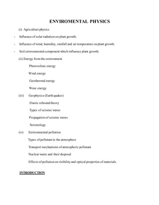
  • 1. ENVIROMENTAL PHYSICS (i) Agriculture physics - Influence of solar radiationon plant growth. - Influence of wind, humidity, rainfall and air temperature onplant growth. - Soil environmental component which influence plant growth. (ii) Energy from the environment Photovoltaic energy Wind energy Geothermal energy Wave energy (iii) Geophysics (Earthquakes) Elastic reboundtheory Types of seismic waves Propagationof seismic waves Seismology (iv) Environmental pollution Types of pollutant in the atmosphere Transport mechanisms of atmospheric pollutant Nuclear waste and their disposal Effects of pollutiononvisibilityand optical properties of materials. INTRODUCTION
  • 2. Environmental physics is an interdisciplinarysubject that integrates the physics processesin the followingdisciplines: the atmosphere, the biosphere, the hydrosphere, and the geosphere. Environmental physics canbe definedas the response of livingorganisms to their environment within the frameworkof the physics of environmental processesand issues. It is structures withinthe relationshipbetweenthe atmosphere, the oceans (hydrosphere), land (lithosphere), soilsandvegetation (biosphere). It embraces the followingthemes: (i) Human environment and survival physics, (ii) Built environment (iii) Renewable energy (iv) Remote sensing (v) Weather, climate and climate change, and (vi) Environmental health. The environment maybe defined as the medium in which any entityfinds itself, For example, for a cloudits environment may be the regionof the atmosphere inwhich it is formed. AGRICULTURE PHYSICS Agriculture physics is concernedwithphysics environment in relationto plant growth. (a) Influence of RadiationEnvironment onPlant Growth Radiation environments. Refer to radiations present inthe atmosphere, commonly comingfrom the sun. Components ofsolar radiation The main components of solar radiationare: (i) Visible light (ii) Infrared radiation, and
  • 3. (iii) Ultraviolet radiation. HEATING EFFECT OF SOLAR RADIATION ON PLANTS Positive effect An optimum amount of heat on plant favours the process of photosynthesis. This enables a plant to make its own foodand hence provide its growth. Negative effects (i) Excessive solar radiation(ultraviolet light) onplants leads to bleaching of greenpigment (chlorophyll). This lowers the amount of foodproducedby photosynthesis to plant and hence a plant may die. (ii) Excessive solar radiationonplants leads to excessive water loss inthe form of water vapour commonlyon plant leaves (transpiration). Hence wilting(drying) of plants may occur. (b) Influence of Aerial Environment onPlant Growth Aerial environments refer to the atmospheric conditionresultingfrom aseries of processes occurringinthe atmosphere. These include air temperature, wind, humidity and rainfall. WIND EFFECT ON PLANT GROWTH Positive effects (a) Wind acts as pollinatingagent for some plants and hence favours plant productivity. (b) Wind also favours evaporationof water from plant leaves and thus maintains water balance for proper plant growth. Negative effects (a) Excessive wind on environments leads to plant breaking or cutting of tree branches. This may lead to the death of plant. (b) As the wind speedincreases further, cell andCuticular damage occurs, followedby death of plant tissue, and a gnarled appearance becomes more apparent.
  • 4. (c) At low wind speeds, the effect seems to be an increase intranspiration, which results in water stress. This stress causesthe plant to adapt by decreasingleaf areaand internodes length, while increasingroot growthand stem diameter. (d) Strong wind may also cause shade off flowers;this lowers plant productivity. Effect of Rainfall onPlant Growth Positive effect An optimum amount of rainfall on plants favours its growth. Water is a raw material for the process of photosynthesis from whichplants obtain their foodand hence their growth. Negative effect Excessive rainfall leads to water logging in soil which in turn leads to root spoil and hence the death of plant. Effect of HumidityonPlant Growth Positive effect Favourable humidity on plants helpplants to conserve water for various activities and in seeds helps the development of new leaves. Negative effect Low humidity results into a greater rate of transpirationand hence may result into plant drying. Effect of Air Temperature of Plant Growth Positive effect An Optimum temperature onplants enhances enzymic activities which in turn gives favourable conditions for plant growth. Negative effect (a) High temperature denature enzymes commonlyfor photosynthesis andhence the death of plant. (b) Low temperature inactivates the plant growth enzymes, hence low growth rate.
  • 5. Wind Belts Wind belts are seasonal strongwind moving in a specifieddirectionina certainregionof the earth. The global wind belts are formedby two main factors: (i) The unequal heating of the earth by sunlight and (ii) The earth’s spin. Here is asimple explanationofthe process The unequal heating makes the tropical regions warmer than the Polar Regions. As a result, there is generallyhigher pressure at the poles and lower at the equator. So the atmosphere tries to sendthe coldair toward the equator at the surface and send warm air northward toward the pole at higher levels. Unfortunately, the spin of the earth prevents this from beinga direct route, and the flow in the atmosphere breaks into three zones betweenthe equator and eachpole. These form the six global wind belts: 3 in the NorthernHemisphere (NH) and3 in the Southern(SH). They are generallyknown as: (1) The Trade winds, which blow from the northeast (NH) and southeast (SH), are, found in the sub tropic regions from about 30 degrees latitude to the equator. (2) The Prevailing Westerlies(SW inNH in SH) which blow in the middle latitudes. (3) The Polar Easterlies whichblow from the east in the Polar Regions. Effects of windbelts to plant 1. Wind belts because the loss of plant leaves and flowers hence lower plant productivity and growth. Loss of leaves lowers the rate of photosynthesis. 2. Wind belts sometimescause plants to leanin directionof movingwing. This changes their directionof growth 3. Trees are brokenby the strongwind. (c) Soil Environment Components WhichInfluence Plant Growth Soil is composedof bothrockparticles and organic matter (humus) – the remains of plants and animals in various stages of decomposition. The humus serves as foodfor many living
  • 6. organisms. Within the soil is a large populationof animals, plants. These break down the humus into soluble substances that can be absorbedby the roots of large plants. Components ofa soil Soil iscomposedof: ( (a) Air, 25% by volume which supports life of soil organisms, (b) Water, 25% which dissolves minerals so that are easilyabsorbed by plants, (c) Organic matter (humus), 5% by volume, (d) Inorganic matter (minerals), 45% byvolume, (e) Biotic organisms, micro – organisms like earthworm, centipedes, millipede, bacteria which decompose organic matter. Types of soil (i) Sandy soil (ii) Silt soil, (iii) Clay soil, and (iv) Loamy soil (sand+ silt + clay soil mixture) Water Movement inthe soil Two forces primarilyaffect water movement through soils, (a) gravity and (b) capillary action. Capillary actionrefers to the attractionof water into soil pores – an attractionwhich makes water move in soil. Capillaryactioninvolves two types of attraction – adhesionand cohesion. Adhesion is the attractionof water to solidsurfaces. Cohesionis the attractionof water to itself. Speed of water in a particular soil type depends on: (i) How much water is in the soil, and
  • 7. (ii) Porosityof the soil. The movement of water in the solidis mainly due to gravity. The porositygives a measure of how much water the soil canhold and the rate at which water flows through the soil. Large pore spaces give a faster rate and vice versa. An experiment to studywater movement insoil An experiment to demonstrate the rate of flowof water in the soil is done using a glass tube and sand type filledinit. Water is poured into the tube and the time taken for water to reach the bottom of the tube in notes. Unsaturatedsoil Saturated soil Soil type Water speed Soil type Water speed Sandy Fastest Sand Slowest Loamy Moderate Loamy Moderate Clay Slowest Clay Highest
  • 8. i. Sand soil have large pore spaces thus allows water to travel downwards through it at a fastest rate. ii. Claysoil canhold water as has very fine pore spaces. iii. Loamysoil allows water movement at a medium rate. Heat transfer inthe soil Withinthe soil heat is transferredby a conductionprocess. Since soilis poor conductorof heat most of the heat from the atmosphere appears at the surface of the earth. An optimum soil temperature favours plants growth but a high temperature can leadto the rottingof plant roots. (d) Techniques for the Improvement ofthe Plant Environment Plant environment can be improved by using wind breaks, shading and mulching. Shading Shading is the process of obstructingplants from excessive solar radiation.
  • 9. Positive Impacts of Shading 1. Prevents excessive loss of water by plants through transpiration. This enhances plant productivity. 2. Preserve moisture inthe soil and hence water supply to plant. Mulching Mulching is the process of coveringthe soil bydry leaves, grasses and or papers. Benefits (Advantages) ofMulching 1. Improve soil moisture. Bare soil is exposedto heat, wind and compactionloseswater through evaporation and is less able to absorbirrigationor rainfall. Using mulches, the soil has greater water retention, reducedevaporation, and reducedweeds. Mulch can also protect trees andshrubs from drought stress andcoldinjury 2. Reduce soil erosionandcompaction. Mulches protect soils from wind water, traffic induced erosionandcompactionthat directlycontributeto root stress andpoor plant health. 3. Maintenance ofoptimal soiltemperatures. Mulches have shown to lower soil temperatures insummer months. Extreme temperatures cankill fine plant roots which can cause stress androot rot. Mulches protect soils from extremetemperatures, either coldor hot. 4. Increase soil nutrition. Mulches withrelativelyhigh nitrogencontent oftenresultin higher yields, but low nitrogenmulches, suchas straw, sawdust and bark, can also increase soil fertilityandplant nutrition. 5. Reductionofsalt and pesticidecontamination. In arid landscapes, evaporating water leaves behind salt crusts. Because mulches reduce evaporation, water is left inthe soil and salts are diluted. Organic mulches can actively accelerate soildesalinizationandhelp degrade pesticides andother contaminants. 6. Improve plant establishment andgrowth. Mulches are usedto enhance the establishment of many woody and herbaceous species. Mulches improve seed germinationand seedsurvival, enhance root establishment, transplant survival, and increase plant performance. 7. Reductionofdisease. Mulches will reduce the splashing of rain or irrigationwater, which can carry spores of disease organisms to stems andleaves of plants. Populations of beneficial microbesthat reduce soil pathogens canbe increasedwith mulches. Mulches can combat disease organisms directlyas well.
  • 10. 8. ReductionofWeeds. Using mulches for weed control is highlyeffective. Mulches can reduce seedgerminationof many weed species andreduce light, which stresses existing weeds. 9. Reduce pesticideuse. Mulches reduce weeds, plant stress, andsusceptibilityto pests and pathogens which translates to reduced use of herbicides, insecticides, and fungicides. MulchProblems(disadvantages ofmulching) 1. i. Acidification. Some types of mulches canincrease soil acidity. 2. ii. Disease. Many mulches made from diseasedplant materials canbe compostedor treated at temperatures that kill pathogens that can be transmittedto healthy plants. 3. iii.Pests. Many organic mulches, especiallywood – based mulches, have the reputationas being “pest magnets”. 4. iv. Weed contamination. Improperlytreatedcropresidues andcomposts as well as bark mulches are oftencarriers of weedseed. Mulchmust be deepenough to suppress weeds and promote healthysoils and plants. Weedcontrol and enhanced plant performance are directly linked to mulch depth. v. Wind Breaks Wind breaks are long rootedstrongplants (trees) that are used to obstruct the path of wind or to slow down the wind. Windbreaks provide many benefits to soil, water, plants, animals and man. They are an important part of the modernday agricultural landscape. Windbreaks come inmany different sizes andshapes to serve many different conservationpurposes. In agriculture, wind breaks protect small growingplants from strongblowing wind Advantages of Windbreaks to Plant Environment 1. i. Control soil erosion. Windbreaks prevent wind erosionfrom causingloss of soil productivity. This eliminates plant roots stresses andthus favours plant growth condition. 2. ii. Increase plant yield. Windbreakresearchsubstantiates that fieldwindbreaks improve cropyields which offsetsthe loss of productionfrom the landtaken out of cultivation. 3. Pesticide sprays. Windbreaks controlpesticide spraydrift and provide buffers to delineate propertylines and protect neighbors. EXAMPLES: SET A
  • 11. Example 01 (a) What is agriculture physics? (02 marks) (b) What are the components of a soil?How do they support the life of a plant? (06 marks) (c) Explain brieflyhow soil temperature affectsplant growth. (02 marks) Example 02 (a) What do you understand by the word environmental physics? (01 marks) (b) Explain how the followingclimatic factors influenceplant growth: air temperature, humidity, rainfall and wind. (06 marks) (c) What are wind belts? Explain the effect of wind belts onplant productivity. (03 marks) Example 03 (a) What is mulching? (02 marks) (b) Give two advantages and two disadvantages of mulching. (04 marks) (c) Discuss the heatingeffect of solar radiationto plant growth. (04 marks) Example 04 (a) Explain two factors that primarilyaffect water movement in the soil (03 marks) (b) Explain the soil environment that favours high cropyield (04 marks) (c) What is shading and what is its purpose? (03 marks) Example 05 (a) (i) Mentionthe components of solar radiation. (ii) How do those components affect plant growth? (04½ marks) (b) What are wind breaks? (02 marks) (c) What are the advantages of wind breaks to plant environment? (03½ marks) ENERGY FROM THE ENVIRONMENT ENERGY
  • 12. Energy is defined as the capacity to do work Or is definedas abilityto do work. Energy is measuredin Joules (symbolJ) Types of energy accordingto their usefulness (i) High grade energy (ii) Low grade energy i. Highgrade energy is the energythat is easilytransformedinto other forms of energyand is more suitable for doing works. Examples are chemical and electrical energy. ii. Low grade energy is the one that is not easilytransformedinto anything else. Examples are the kinetic energyof molecules due to their randomness and the potential energy due to the forces betweenmolecules. ENERGY SOURCES There are two types of energy sources, namely: (i) Primaryenergy sources, (ii) Secondaryenergysources. i. Primaryenergysources Primaryenergysources are sourcesof energythat are usedin the form in which they occur naturally. Primaryenergysources fall into two groups: (a) Finite energysources, (b) Renewable sources. a. Finite energysources are those energysources that last after a number of years when exploited. Examples are coal, oil, natural gas, and nuclear fuels.
  • 13. b. Renewable energysources: these cannot be exhausted. Examples are solar energy, biofuels, hydroelectricpower, wind power, wave power, tidal and geothermal power, wind power, wave power, tidal and geothermal power. ii. Secondaryenergysources Secondary energysources are usedin the non – natural form. SOLAR ENERGY Nature of solar energy The sun’s energy is produced by thermonuclear fusion. Not all of the solar radiationarriving at the edge of the Earth’s atmosphere reaches the Earth’s surface. About 30% is reflectedbackinto space by atmospheric dusts and by the polar ice caps. About 47% is absorbedduring the day by the land and sea and becomes internal energy(i.e. heats the Earth). At night this is radiated back into space as infrared. 23% causes evaporationfrom the oceans and sea to form water vapour. This results into rain and hence hydroelectric power. -0.2% causes convectioncurrentsinthe air, creatingwind power which in turn causes wave power. -0.02% is absorbedby plants during photosynthesis and is storedinthem as chemical energy. Plants are sources of biofuels Solar constant Solar constant is defined as the solar energy falling per secondon a square meter placed normal to the sun’s rays at the edge of the Earth’s atmosphere, when the Earth is at mean distance from the sun. Its value is about 1.35 kWm2 The amount of solar radiationreceivedat any point on the earth’s surface depends on: (i) The geographical location, (ii) The season, (summer or winter)
  • 14. (iii) The time of the day, the lower the sun is in the sky the greater is the atmospheric absorption. (iv) The altitude; the greater the height above sea level the less is the absorptionby the atmosphere, clouds and pollution PHOTOVOLTAIC DEVICES (SOLAR CELLS) A solar cell (PV, cells) is aPN junctiondevice which converts solar energydirectlyinto electrical energy. How it Works PV cells are made of at least two layers of semiconductor material. One layer has a positive charge (p – type material), the other negative (n-type material). When light enters the cell, some of the photons from the light are absorbed by the semiconductoratoms, freeing electrons from the cell’s negative layer to flow through an external circuit and back into the positive layer. This flowof electrons produces electriccurrent. Uses of the solar cell 1. (i)Are usedto power electronics insatellite andspace vehicles. 2. (ii)Are usedas power supply to some calculators. 3. (iii)Are usedto generate electricityfor home, office andindustrial uses. Series arrangement ofsolar cells Solar panel (module) is asealed, weatherproof package containing a number of interconnectedsolar cells so as to increase utilityof asolar cell.
  • 15. When two modules are wired together inseries, their voltage is doubled while the current stays constant. When two modules are wired in parallel, their current is doubledwhile the voltage stays constant. To achieve the desiredvoltage and current, modules are wired in series and parallel into what is calleda PV array. The flexibilityof the modular PV system allows designers to create solar power systems that can meet a wide variety of electrical needs, no matter how large or small. Efficiencyofa photovoltaicsystem The output power of a solar cell depends on: (i) The amount of light energy from the sun falling on a solar panel (the intensityof light). (ii) The orientation of the solar panel. More electricityis producedif light falls perpendicular to panels. (iii) The surface areaof the panel. Large area collects more solar energyand hence greater electricity. The best designed solar cell can generate240Wm-2 in brightsun lightat an efficiency of about 24%.
  • 16. Advantages of photovoltaic systems 1. Solar cells canproduce electricitywithout noise or air pollution. 2. A photovoltaic system requires no fuels to purchase. 3. Panels of photovoltaic cells are usedfor small – scale electricitygenerationinremote areas where there is sufficient sun. 4. Net metering: This has the potential to help shave peak loads, which generallycoincide with maximum PV power production. 5. The electricityfrom aPV system is controllable. Disadvantages ofphotovoltaicsystems 1. They require an inverter to convert the d.c output into a. c for transmission. 2. They produce electricityonlywhen there is sunlight. Hence theyneed backup batteries to provide energy storage. 3. Suitable in areas which receives enoughsunlight. 4. Photovoltaic large scale power generationis cost effective. This is due to large surface area of cells requiredfor generatinghighpower outputs and the need to convert d.c to a.c for transmission. 5. Comparedto other energysources, PVsystems are an expensive way to generate electricity. 6. The available solar resourcedepends ontwo variables: The latitude at which the array is locatedand the average cloudcover. WIND ENERGY Winds are due to conventional currents inthe air caused by uneven heating in the earth’s surface by the sun. Wind energy is extractedby a device called windturbine. Wind speed increases withthe height; it is greatest in hillyareas. It is also greater over the seaand coastal areas where there is less surface drag. Wind turbines are also called aerogenerator or windmills (oldname)
  • 17. Types of windturbines There are two types of wind turbines; (i) Horizontal axis wind turbines (HAWT) (ii) Vertical axis wind turbines (VAWT) Horizontal axis windturbine(HAWT) HAWT has two or more longvertical blades rotatingabout a horizontal axis. Modern HAWTs usually feature rotors that resemble aircraftpropellers, whichoperate onsimilar aerodynamic principles, i.e. the air flow over the airfoil shaped blades creates aliftingforce that turns the rotor. The nacelle of a HAWT houses a gearboxand generator (alternator). Advantage of HAWT 1. HAWTS can be placed on towers to take advantage of higher winds farther from the ground. Disadvantages ofHAWT 1. The alternator (generator) is pacedat the topof the supportingtower. 2. Can produce power in a particular wind direction. Vertical axis windturbine (VAWT) In vertical axis, the blades are long and vertical and can accept wind in any direction. The blades are propelledby the drag force onthe blades as the wind flows. Advantages of VAWT 1. It can harness wind from any direction 2. Typically operate closer to the ground, which has the advantage of allowing placement of heavy equipment, like the generator and gearbox, near ground level rather than in the nacelle. Disadvantages ofVAWT 1. Winds are lower near ground level, so for the same wind and capture area, less power will be producedcomparedto HAWT. 2. Time varying power output due to variation of power during a single rotationof the blade.
  • 18. 3. The need for guy wires to support the tower. 4. Darrieus VAWTS are not self startinglike HAWTS. (More colorful picture andvideos during lecture) Power ofaWind Turbine Consider a wind turbine with blades of length, r (area A), the wind speedis v and the air densityis ρ. Assuming that the air speedis reducedto zero by the blades. Kinetic energyof the wind, K.E = Kinetic energyper unit volume K.E per volume = ÷ volume = The blades sweeps out an area A in one turn, so the volume of air passing in one secondis Av. Kinetic energyper second = K.E per unit volume x volume per second K.E per second= = The available windpowerisP =
  • 19. Extractable power The power extractedby the rotatingblades is much less than the available wind power. This is because: (i) The velocityof the wind is not reducedto zero at the blades (ii) Losses due to frictionat the turbine and alternator (iii) Due to losses inboththe gear train and generator. The power actually capturedby the wind turbine rotor, PR, is some fractionof the available power, definedby the coefficient of performance, Cp, which is essentiallyatype of power conversionefficiency:
  • 20. = The extractable power (electrical power output) is given by Where ns and nb are efficiencies (power output over power input) for the generator and the gearbox. Variations ofpower withwindspeed The power curve for a wind turbine shows this net power output as a functionof wind speed. i. Cut inwindspeed: This is the lowest speedat which the wind turbine will start generating power. Typical cut – in wind speeds are 3 to 5 m/s. ii. Nominal windspeed: This is the lowest speedat which the wind turbine reaches its nominal power output. Above this speed, higher power outputs are possible, but the rotor is controlledto maintaina constant power to limit loads and stresses onthe blades.
  • 21. iii. Cut – out windspeed: This is the highest wind speedwhich the turbine will operate at. Above this speed, the turbine is stoppedto prevent damage to the blades. Advantages of Wind Energy 1. Wind Energy is an inexhaustible source of energyand is virtually a limitless resource. 2. Energy is generatedwithout polluting environment 3. This source of energyhas tremendous potential to generate energyonlarge scale. 4. Like solar energyand hydropower, wind power taps a natural physical resource, 5. Windmill generators don’t emit any emissions that canlead to acid rain or greenhouse effect. 6. Wind Energy can be useddirectly as mechanical energy 7. In remote areas, wind turbines can be usedas great resource to generateenergy 8. In combinationwith Solar Energy they can be used to provide reliable as well as steady supply of electricity. 9. Land around wind turbines can be used for other uses, e.g. Farming. Disadvantages ofWind Energy 1. Wind energy requires expensive storage duringpeak productiontime. 2. It is unreliable energy source as winds are uncertainand unpredictable. 3. There is visual and aesthetic impact onregion 4. Requires large openareas for settingup wind farms. 5. Noise pollutionproblem is usuallyassociatedwithwind mills. 6. Wind energycan be harnessedonly in those areas where wind is strongenough and weather is windy for most parts of the year. 7. Usually places, where wind power set-upis situated, are away from the places where demand of electricityis there. Transmissionfrom suchplaces increasescostof electricity.
  • 22. 8. The average efficiencyof wind turbine is very less as comparedto fossil fuel power plants. We might require many wind turbines to produce similar impact. 9. It can be a threat to wildlife. Birds do get killedor injured when they flyinto turbines. 10. Maintenance cost of wind turbines is high as they have mechanical parts which undergo wear and tear over the time. NB: Even though there are advantages of wind energy, the limitations make it extremely difficult for it to be harnessedand prove to be a setback GEOTHERMAL ENERGY Geothermal energyis the energy from nuclear energychanges deep in the earth, which produces hot dry rock. Geothermal energyoriginates from the heat retainedwithin the Earth since the original formationof the planet, from radioactive decayof minerals, and from solar energyabsorbed at the surface. Harnessing Geothermal Energy Most high temperature geothermal heat is harvested in regions closeto tectonicplate boundaries where volcanic activity rises closeto the surface of the Earth. In these areas, ground and groundwater can be found with temperatures higher than the target temperature of the application. Geothermal energyis extractedby using two methods: (i) A heat pump system (ii) Hot dry rockconversion The heat pump system Hot aquifers are layers of permeable (porous) rocksuchas sandstone or limestone at a depth of 2 – 3 km which contains hot water at temperatures of 60 – 1000C. A shaft is drilledto aquifer and the hot water pumped up it to the surface where it is usedfor district space and water heating schemes or to generate electricity. A secondshaft may be drilledto returnthe cool water to the rock.
  • 23. The hot dry rockconversion These are impermeable hot dry rocks foundat depth of 5 – 6 km, have temperature of 2000C or more. Two shafts are drilledand terminate at different levels inthe hot rockabout 300 m apart. The rocks near the end are fracturedby explosionor bymethods to reduce the resistance to the flow of coldwater which is pumped under very high pressure (300atm) down the injectionshaft and emerges as steam from the top of the shallower shaft.
  • 24. Uses of geothermal energy Geothermal energycan be used for electricityproduction, for direct use purposes, and for home heating efficiency(throughgeothermal heat pumps). Advantages of geothermal energy 1. Geothermal power plants provide steady and predictable base load power. 2. New geothermal power plants currentlygenerate electricityat low cost. 3. Responsiblymanaged geothermal resources candeliver energyand provide power for decades. 4. Geothermal power plants are reliable, capable of operatingabout 98 percent of the time. 5. Power plants are small, require no fuel purchase and are compatible with agricultural land uses. 6. Geothermal plants produce a small amount of pollutant emissions comparedto traditional fossil fuel power plants. Disadvantages ofgeothermal energy 1. Many of the best potential resources are locatedinremote or rural areas, often of federal or state lands 2. Although costs have decreasedinrecent years, explorationand drillingfor power productionremainexpensive 3. Using the best geothermal resources forelectricityproductionmayrequire an expansion or upgrade of the transmissionsystem. 4. The productivity of geothermal wells may decline over time. As a result, it is crucial that developers manage the geothermal resourcesefficiently. WAVE ENERGY Wave energy is the energy extractedfrom the oceansurface wave. Energy that comes from the waves in the oceansounds like a boundless, harmless supply. Machinery able to exploit wave power is generallyknown as a wave energyconverter (WEC)
  • 25. Wave power Waves in the sea have kinetic energyand gravitational potential energyas the rise and fall. Consider a sine wave of wave length λ spread over a width d the amplitude of the wave is a and the time periodis T. The power in a wave come from the change in potential energyof the water as it rotates on the circuit paths beneath the surface. It can be shown that the power carriedforwardby a wave is given by: Wave EnergyFlux The mean transport rate of the wave energythrough a vertical plane of unit width , parallel to a wave crest, is called wave energyflux. From above, Harvesting wave energy There are two type of system: 1. i. Offshore systems indeepwater more than 141 feet deep. The Salter duckmethod. (a) Pumps that use bobbing motionof waves. (b) Hoses connectedto floats onsurface of waves. As float rises and falls , the hose stretches andrelaxes, pressurizingthe water which then rotates aturbine 2. ii. Onshore systems are built along shorelines andharvest energyfrom braking waves. (a)Oscillatingwater columns are of concrete or steel andhave an openingto the sea below the waterline. It uses the water to pressurize an air column that is drawn through the turbine as waves recede.
  • 26. (b)A Tapchan is a taperedwater system insea cliffs that forces waves through narrow channels and the water that spills over the walls is fedthrough a turbine. (c)A Pendulor device is a rectangular box with a hinged flap over one side that is opento the sea.Waves cause the flap to swing back and forthand this powers a hydraulic pump and generator. Advantages of Wave energy 1. Renewable: It will never run out. 2. Environment friendly: Creatingpower from waves creates no harmful byproducts such as gas, waste, and pollution. 3. Abundant and widely available: Another benefit to using this energy is its nearest to places that can use it. 4. Variety of ways to harness: Current gathering methodrange from installedpower plant with hydro turbine to seafaring vessels equipped with massive structures that are laid into the seato gather the wave energy. 5. Easily predictable: The biggest advantage of wave power as against most of the other alternative energysource is that it is easilypredictable and can be usedto calculate the amount that it can produce. 6. Less dependencyon foreignoil cost. 7. Non damage to land. Disadvantages ofwave energy 1. Suitable to certainlocations: The biggest disadvantage to gettingyour energy from the wave is location. Onlypower plants and town near the oceanwill benefit direct from it. 2. Effect onmarine ecosystem: Large machine have to be put near and in the water gather energy from waves .These machines disturb the seafloor, changes the habitat of near- shore creatures (like crabs and starfish) and create noise that disturbthe sealife around them. 3. Wavelength: Wave power is highly dependent on wavelength i.e. wave speed, wave length, and wavelength and water density.
  • 27. 4. Weak performance inRough Weather: The performance of wave power drops significantlyduring rough weather. 5. Noise and Visual pollution: Wave energygenerators may be unpleasant for some who live close to coastal regions. They looklike large machines working in the middle of the oceanand destroythe beauty of the ocean. They also generate noise pollutionbut the noise is oftencoveredby the noise of waves which is much more than that of wave generators. 6. Difficult to convert wave motioninto electricityefficiently. 7. Difficult to designequipment that can withstand storm damage and saltwater corrosion. 8. Total cost of electricityis not competitive withother energysources. 9. Pollutionfrom hydraulic fluids and oils from electrical components. TIDAL ENERGY Tidal Power is the power of electricitygenerationachievedby capturing the energy containedin moving water mass due to tides. Two types of tidal energy can be extracted: Kinetic energy of currents betweenebbingand surging tides and potential energy from the differenceinheight between high and low tides. Causes of Tides Tides are causedby the gravitational pull of the moon, and to a lesser extent the sun, on the oceans. There is a high tide places near the moonand also opposite onthe far side.
  • 28. i. High(spring) tide: Occurs whenthere is full moon. The moon, sun and earth are in line the moonbeing between earthand sun. The pulls of the moonand sun reinforceto have extrahigh tides. ii. Lowest (neap) tide: Occurswhen there is half moonand the sun and moonpulls are at right angles to eachother. iii. Harnessing Tidal Energy Tidal energy can be harnessedby building a barrage (barrier), containingwater turbines and sluice gates, across the mouthof river. Large gates are openedduring the incoming (flood) tide, allowing the water to pass until high tides, when they are closed. On the outgoing tide, when a sufficient headof water has built up, small gates are opened, lettingthe potential energyof the trapped water drive the turbines and generate electricity. Advantages of Tidal Energy 1. Decrease relianceoncoal driven electricityso less CO2 emissions. 2. Changing technologyallowingquicker constructionof turbines, whichin turn increases likelihoodof investment with a shorter return. 3. Once constructedvery little costto runand maintain. 4. Tidal energyis renewable and sustainable. Disadvantages ofTidal Energy 1. Intermittent energyproductionbasedaround tides creates unreliable energysource. 2. High constructioncosts 3. Barrages can disrupt natural migratoryroutes for marine animals. 4. Barrages can disrupt normal boating pathways. 5. Turbines can kill up to 15% of fishin area, although technologyhas advanced to the point that the turbines are moving slow enough not to kill as many. Tidal Power If the tidal height (level) is h and the estuaryarea is A, then the mass of water trapped being the barrier is and the centre of gravity is h/2 above the low tide level.
  • 29. The maximum energyper tide is therefore Potential Energyof tide = Averaged over a tidal periodof T (approx. 12 hours a day), this gives a mean power available of. Average tidal power = Note that the efficiencyof the turbines (generator) will determine howmuch of this tidal power will be harnessed. EXAMPLES: SET B Example 01 The power output p of a windmill can be expressedas where A is the area swept out by the windmill blades (sails), is the densityof air, v is the wind speedand k is a dimensionless constant (a) Show that the units onboth sides of this expressionare the same (b) Sketch a graph to show how the power increases withwind speedas v rises from zero to 15ms-1 Solution (a) Units on L.H.S = Nms-1 Unit on R.H.S. = m2 (kgm-3) x (ms-1)3 = (kgms-2) ms-1=Nms-1
  • 30. (b) Variation of power with speed 0 Example 02 The radiation receivedfrom the sun at the earth’s surface ina certaincountryis about 600 Wm-2 averaged over 8 hours in the absence of cloud. (a) What area of solar panel would be neededto replace apower stationof 2.0 GW output, if the solar panels used couldconvert solar radiationto electrical energyat an efficiencyof 20% (b) What percentage is this area of the total of the country(which is about 3 x 10¹¹m2)? (c) If the total power stationcapacityis about 140 GW, what percentage of the surface of the countrywould be coveredby solar panels if all the power stations were replaced? Solution (a) Output of a solar panel
  • 31. (b) Percentage areato the country (c) Area of solar panels required Percentage areato the country Example 03 (a) What are aerogenerators? (b) Estimate the maximum power available from 10m2 of solar panels and calculate the volume of water per secondwhich must pass through if the inlet and outlet temperatures are 200C and 700C. Assume the water carries away energy at the same rate as the maximum power available. The specific heat capacityof water is 4200 Jkg-1 and solar constant is 1.4 kWm-2. Solution (a) Aerogenerators are devices that convert the kinetic energyof wind into electrical energy. E.g. windmill. (b) Maximum power available from solar panel Volume of water per secondusedis given by
  • 32. 1400 = Example 04 A coal – fired power station has an output of 100mW. Given that its efficiency is 45%, how much coal must be suppliedeach day? Assume 1 tonne of coal gives 3 x 10¹⁰ of energy. Solution Input power of the stationis given by Total input energyin a day is The amount of coal requiredis Example 05 Calculate the energy required transport1000 tones of oil along a 100km pipeline; given that 0.05 kW hours of energy is used to shift each tone of oil along each km of pipeline. Given that 1 tonne of oil releases 4.2 x 10¹⁰ J if burned, what percentage of the total energy
  • 33. available from 1000 tonnes of oil is used to shift the oil along the pipeline? (Ans: 18GJ, 0.043%) Example 06 A hydroelectric power station has efficiency of 25%. The water driving the turbines falls through a height of 300m before reaching the turbines. Calculate the volume of water that must pass through the turbines each second to give a power output of 2mW. Assume the densityof water is 1000kg-3. Solution Power of the falling water But, Example 07 The solar energy flux near the Earth is 1.4W m-2. A solar power station consists of concave mirrors that focus sunlight onto a steam boiler. What must be the minimum mirror area to given an output 1 mW, assuming 100% efficiency? Why in practice, should the mirror area be greater? Solution Minimum mirror areais given by
  • 34. The mirror area should be greater to achieve such a power output because part of the incident energy is absorbedby the mirror. Example 08 A solar panel attached to the roof of a house is used to heat water from 50C to 400C. If the water flows through the panel at a rate of 0.012kgs-1 Calculate the heat gained per second by the water. Assume the specific heat capacityof water is 4200Jkg-1K-1. (Ans. 1764 Q) Example 09 An aerogenerator has a power output that is proportional to (wind speed) 2 and its efficiency varies with wind speed. On a day when there is a steady wind of speed 9 ms-1, the power output is 40kW operating at an efficiency of 20%. If the wind speed on next day is 13.5 ms-1 and the efficiencyincreases to 25% what is the new power output? Solution Power output α efficiency × (wind speed)2 Example 10 Estimate the energy released from a tidal power station if 100 km3 of water raised to height of 1.5m by the tide behind a tidal barrier. What would be the mean power output of such a stationif its efficiencyis 25% and there are two tides per day? Solution The tidal power is given by Note that the centre of gravity of water mass is at the half height up.
  • 35. Mean power output is Example 11 An open boat of width 1.0 m has a total weight of 3000N.Used near a beach, it bobs up and down through 0.5 m once every 5s. Calculate the losses of P.E. every time it drops from a crest to athrough. Hence estimate the meanpower available per meter of beachwaves. Solution Loss in P.E. is given by The mean power available per meter is 300 W Example 12 (a) If energyis conserved, why is there energycrisis? (b) Explain the terms high grade and low grade energyand give examples. (c) Draw an energy flow diagram for a hydroelectric power station. Why does such a station have a much greater efficiencythan a thermal power station? Refer Advanced Physics byTom Duncan fiftheditionfor more problems onenergy. GEOPHYSICS Geophysics is the branch of physics which deals with the study of seismic waves and the Earth’s magnetic and gravity fields and heat flow.
  • 36. Because we cannot directly observe the Earth’s interior, geophysical methods allow us to investigate the interior of the Earth by making measurements at the surface. Without studying these things, we would know nothing of the Earth’s internal structure. STRUCTURE OF THE EARTH Major zones of the earth The earth is divided into two major zones, namely; (a) Outer zone, and (b) Inner zone. a) Outer zone: the earth’s outer zone consists of; (i) The hydrosphere – water bodies, (ii) The atmosphere – gaseous envelope (iii) The biosphere – living organisms, plant and animals b) Inner zone: the earth’s inner zone consists of; (i) The crust – lithosphere (ii) The mantle – mesosphere, (iii) The core – barysphere Atmosphere is the envelope of gases that surround the Earth (oxygen, nitrogen, carbon dioxide, etc) Hydrosphere is the water bodies filling the depressions in the Earth. Examples are rivers, oceans, seas, oasis, Lithosphere is the solidouter most part of the earth. EARTH’S LAYERS Layers definedby composition Layers are defined by composition because of density sorting during an early period of partial melting, Earth’s interiors not homogeneous.
  • 37.  Crust – the comparatively thin outer skin that ranges from 3 kilometers at the oceanic ridges to 70 kilometers insome mountainbelts. It makes up 1% of the Earth’s volume. Continental crust (SIAL, Siliconand aluminium) Average rockdensityabout 2.7 g/cm3 Its densityvaries between 2.0 to 2.8 g/cm3 Composedof siliconand aluminium Floats higher on the mantle forming the land masses and mountains. It is 30 to 70 km thick. Oceanic crust (SIMA), siliconand magnesium) Oceanic crust ranges from 3 to 15 km thick Densityvary between3.0 to 3.1 g/cm3 Floats lower on the mantle formingthe oceanic basins. It is about 8 km thick.  Mantle – a solid rocky (silica-rich) shell that extends to a depth of about 2900 kilometers. It makes up 83% of the Earth’s volume The mantle can further be dived into: (i) Upper layer of mantle (Asthenosphere) (ii) Transitionlayer and, (iii) Lower layer of mantle (Mesosphere) Upper mantle is a rigidlayer of rockwith average density3.3kgm-3 Transitionlayer is the layer that separates upper and lower mantle. Lower mantle plays an important role in tectonic plate movement which creates earthquakes and volcanoes. Its densityis about 5.7 kgm-3
  • 38. Note: The mantle rocks are saidto be in a plastic state. The upper part of a mantle has a temperature of about 8700C. The temperature increases downwards through the mantle to about 22000C near the core.  Core - an iron – rich sphere having a radius of 3486 kilometers making up 16% of the Earth’s volume The core is divided into two parts: (i) Outer core (ii) Inner core i. Outer core is a liquid of molten iron and nickel alloys. The Earth’s magnetic field is generatedwithin the outer core due to convective. It is 2270 kilometersthick. ii. Inner core is a solid iron and nickel alloys. The temperature within the inner core is higher than the outer core but the inner core is solid, this is because higher pressure in this regioncauses the meltingpoint to rise. It is a sphere of radius of 1216 kilometers. Average densityis nearly 11 gcm-3and at Earth’s center. Layers definedby physical properties Lithosphere (sphere of rock) Earth’s outermost layer Consists of the crust and uppermost mantle Relativelycook, rigid shell Averages about 100 kilometers in thickness, but may be 250 kilometers or more thick beneath the older portions of the continents Asthenosphere (weaksphere partially molten) Beneath the lithosphere, inthe upper mantle to a depth of about 660 kilometers Small amount of melting in the upper portion mechanically detaches the lithosphere from the layer below allowing the lithosphere to move independently of the asthenosphere i.e. allows tectonic plate movement.
  • 39. Mesosphere or lower mantle Rigid layer betweenthe depths of 660 kilometersand 2900 kilometers Earth’s major boundaries Discontinuity is the name given to any surface that separates one layer from another layer of the Earth. The Moho (Mohorovicicdiscontinuity) Discoveredin1909 by Andriaja Mohorovicic Separates crustal materials (crust)from underlyingmantle. Gutenberg discontinuity  Discoveredin1914 byBeno Gutenberg  Is the boundary between the outer and inner core. The Earth’s Structure
  • 40. TEMPERATURE INSIDE THE EARTH Earth’s temperature gradually increases with an increase in depth at a rate known as the geothermal gradient. Temperature varies considerablyfrom place to place Averages between about 200C and 300C per kilometer in the crust (rate of increase is much less inthe mantle and core) The rate of heat flow within the Earth depends on: (i) The thermal conductivity of the rock, (ii) Temperature gradient of the rock Sources ofheat Energywithinthe Interiorofthe Earth Major processesthat have contributedto Earth’s internal heat include: 1. Heat emitted by radioactive decay of isotopes of uranium (U), thorium (Th), and potassium (K). 2. Heat releasedas ironcrystallizedto form the solidinner core. 3. Heat releasedbycollidingparticles duringthe formationof Earth. 4. Gravitational work done by the Earth due to its rotationthroughits own axis. 5. Electronmotioninthe core behaves like an electriccurrent. Heat Lost by the Earth Heat in the earth is transferredbythe process of; (i) Convectionand (ii) Conduction In the solid inner core and in the Earth’s crust heat is transmitted by conduction process. Rates of heat flowin the crust vary. In the Mantle heat is transmittedby conductionprocess. Rates of heat flowin the crust vary.
  • 41. In the Mantle heat is transmitted by convection process. There is not a large change in temperature with depth in the mantle. Mantle must have an effective methodof transmittingheat from the core outward. Transfer of heat inthe Earth by mantle convection Uses of the Mantle 1. The mantle transfers heat by convection from the earth’s crust to the out regions of the earthand thus help it to regulate its temperature 2. The upper part of the mantle is molten, this allows tectonic plates movements. EARTHQUAKES An earthquake is a sudden motion or shaking of the earth caused by a sudden release of energy that has accumulated within or along edges of the earth’s tectonic plates. Earthquakes occur within the Earth’s crust along faults that suddenly release large amounts of energy that have built up over long periods of time. The shaking during an earthquake is causedby seismic waves.
  • 42. Seismic waves are propagating vibrations that carry energy from the source of the shaking (earthquake) outward in all directions. Seismic waves are generated when rock within the crust breaks, producing a tremendous amount of energy. The energy released moves out in all directions as waves, much like ripples radiating outward when you drop a pebble in a pond. CAUSES OF EARTHQUAKES (SEISMIC WAVES) The main causes of the Earthquakes and so seismic waves are: 1. Movement of tectonic plate. 2. Volcanic activity. 3. Landslide and avalanches. 4. Rebound of the crust. 5. Human activities. Movement oftectonic plate The Earth’s crust is made up of segment (layers) called tectonic plates which are slowly driftingin various directions. Tectonic plates maycreate a fault. A boundary is a line where two tectonic plates meet. A geologic fault is a fracture in the earth’s crust causing loss of cohesion and accompanied by displacement alongthe fracture. How an earthquake is formed Tectonic plates grind past each other, rather than slide past each other smoothly. As the plates move past each other they can become locked together due to friction. For some time, they don’t move and strain energy builds up. Stresses builds between them until fractional force holding the plates together give away. The plates move suddenly, releasing the energy and then held again. This sudden jerkis what is felt as an earthquake. Note (a) The Earth’s crusts near tectonic plate edges are forced to bend, compress, and stretch due to the internal forces withinthe earth, causing earthquakes. (b) Nearly all earthquakes occur at plate boundaries.
  • 43. Volcanic activity Molten rock “magma” from the mantle is forced through a weak point in the Earth’s crust creating a volcanic eruption. When magma reaches the Earth’s surface it is known as “Lava”. Successive eruptions leads to the buildup of lava on the sides of the vent creating the familiar “cone – shape” of a volcanoes Earthquakes may be created by the violent explosions which occur if there are sudden movements of the magma. Landslides andavalanches A landslide occurs when a large mass of land slips down a slope. An Avalanche occurs when a large mass of snow pours down a mountain side. Both of these effects can start an earthquake Rebound of the crust Elastic rebound theory state that "as tectonic plates move relative to each other, elastic strain energy builds up along their edges in the rocks along fault planes". Since fault planes are not usually very smooth, great amount of energy can be stored (if the rock is strong enough) as movement is restricted due to interlock along the fault. When the shearing stresses induced in the rocks on the fault planes exceed the shear strength of the rock, rupture occurs. It follows from this that if rocks along the fault are of a certain strength, the fault is a certain length, and the plates are slipping past each other at a defined rate, it is possible to calculate the amount of time it will take to build up enough elastic strain energy to cause an earthquake and its probable magnitude. When a fault breaks it release elastic strainenergyit stored, andhence earthquake. Human activities Human activities such as those caused by nuclear bombs can create earthquake, together with mine actives. EARTHQUAKE TERMS Energy released by an earthquake moves outwards from the origin in the form of concentric waves. Focus (Hypocenter) is the point in the Earth where seismic waves originate. Epicenter is the point onthe earth’s surface verticallyabove the focus.
  • 44. Hypocentral distance is the distance betweenthe focus and the seismic detectionstation. Epicentral distance is the distance betweenthe epicentral and the seismic station. S = Seismic station E = Epicenter ES = Epicentral distance TYPE OF SEISMIC WAVES i. Seismic waves are elasticwaves that propagate within the earth. There are two type of seismic waves: 1. ii. Bodywaves, spreadoutward from the focus inall directions. 2. iii. Surface waves (Long, L – waves) spread outward from the epicenter to the Earth’s surface along the crust, similar to ripples on a pond. These waves can move rock particles in a rolling motion that very few structures can withstand. These waves move slower than body waves. BODY WAVES There are two types of Body Waves (1) PrimaryP – wave and (2) Secondary, S – waves 1. 1. Primary Wave (P – wave): Are longitudinal (compression) wave (travels in the same directionthe waves move) Characteristics ofP – waves 1. Are the fastest seismic waves (7 – 14 km/second). Arrives at recording station first, hence the name primary means first. 2. Can pass through solid, gas and liquid, hence can pass through crust, mantle and the cores. 3. Are longitudinal compression waves. The rocks that transmit the P – waves are alternately compressedand expanded. VelocityofP – waves
  • 45. The velocity of primary waves depends on the density, bulk modulus B and the shear modulus In solid, = In liquid = A fluid cannot support shear stresses hence 2. Secondary Wave (S – wave): Are transverse (shear) wave (travels perpendicular to the wave movement). Characteristics ofS – waves 1. i. Slower moving (3.5 – 7 km/second) hence are detectedafter primarywaves. 2. ii. Caused by a shearingmotion 3. iii. Cannot pass through a fluid (gas or liquid) because they are transverse. Hence are unable to pass through the liquid outer core. VelocityofS – waves The velocityof shear waves depends on the density and the shear modulus In solid, = In liquid = Note: Since the density and states of the earth layers varies, the speed of the seismic waves also vary from layer to layer, the solid part showing greater speed and the liquid ones lower speed.
  • 46. Primarywave and secondarywave Variationofspeedof body waves withdepth SURFACE WAVES/LONG WAVES
  • 47. Surfaces waves are producedwhen earthquake energy reaches the Earth’s surface. These are the slowest moving waves, but are the most destructive for structures onearth There are two types of L – Waves: (i) Love long waves (ii) Rayleighlong waves i. Love Waves Love waves are Transverse horizontal motion, perpendicular to the direction of propagation and generallyparallel to the Earth’s surface. They are formed by the interaction of S waves with Earth’s surface and shallow structure and are dispersive waves. The speed at which a dispersive wave travels depends on the wave’s period. Characteristics ofLove Waves 1. i. Love waves are transverse and restrictedto horizontal movement (horizontallypolarized). 2. ii. The amplitude of ground vibration caused by a Love wave decrease with depth. The rate of amplitude decrease withdepth also depends on the period/frequency. 3. iii. Loves wave are dispersive, i.e. wave velocity is dependent on frequency; low frequency – higher velocity. 4. iv. Speed of love waves is between 2.0 and 4.4 km/s 5. v. Love waves travels within the earth’s crust only.
  • 48. LOVE WAVE RayleighWaves Rayleigh waves are vertically polarized long waves. The slowest of all the seismic wave types and in some ways the most complicated. Characteristics ofRayleighWaves 1. Rayleigh waves are transverse and restrictedto vertical movements (verticallypolarized). 2. The amplitude of Rayleigh wave decreases with depth. The rate of amplitude decrease with depth depends on the period/frequency 3. Rayleigh wave are dispersive, i.e. wave velocity dependent on frequency; low frequency – high velocity 4. Speedof love waves is between 1.0 and 4.2 km/s slowest of all waves. 5. Travels within the earth’s crust only. 6. Depth of penetration of the Rayleigh waves depend frequency, with lower frequencies, penetratinggreater depth.
  • 49. PROPAGATION OF SEISMIC WAVES Like all other types of waves, seismic waves may undergo, (i) Reflection, (ii) Refraction, (iii) Dispersion, (iv) Diffraction, (v) Attenuation. Seismic reflection: Seismic waves bounce (reflect) rockboundaries of different rocktype (density). Seismic refraction: Waves change velocity and direct (refract) when they enter a medium of different density it the one they just passed through. Seismic Dispersion: surface waves are dispersive which means that different periods travel at different velocities. The effects of dispersion become more noticeable with increasing distance because the long travel distance spreads the energyout (it disperses to energy). SEISMIC WAVE PATHS By comparing the data recorded by many stations all over the world the nature, speed and the paths of the seismic waves can be determined. This information can be used to tell us about the earth’s interior suchas densitysand state in each layer. L – Waves travel within the Earth’s crust only
  • 50. P and S waves travel through the earth in a curve path. The waves are refracted because their speeds a constantly changing with depth due to continue increase in density. Waves are also stronglyrefractedthe Mantle – Core boundary. Surface waves travels through the Earth crust only Shadow zone is the regionon the Earth’s surface where no S or P waves are present. This lies between1050 and 1400. Onlysurface waves may be detectedinthis region. Shadow zone occurs because: (i) P – Waves are stronglyrefractedat the liquid outer core. (ii) S – Waves can’t travel through the liquid outer core. Seismic waves can also be used to locate the discontinuities in the earth’s crust. A change in densityor crackwould affect the propagation of the waves. This alterationinthe wave’s path or speedwould indicate the discontinuity.
  • 51. The fact that S waves do not travel through the core provides evidence for the existence of aliquid layer beneath the rockymantle. The change in the velocity of P waves at crust – Mantle boundary reveals the presence of Mohorovicic discontinuity P waves passing through the inner core show increased velocity suggesting that the inner core is solid. Both P and S – Waves slow down when they reach the asthenosphere. Because of this scientists knowthat the asthenosphere is partiallyliquid MEASUREMENTS OF EARTHQUAKES
  • 52. i. Seismology is the scientific study of earthquakes (seismic waves) and artificially produced vibrations in the earth.Seismograph is a sensitive instrument that is used to record earthquakes and seismic waves (i.e. ground movements). ii. Seismogram is the recordof groundmovement drawn by a seismograph. The arrival ofseismicwaves at a station Seismograph consists of a heavy weight suspended from a frame fixed into the ground. When the earth vibrates the frame moves but the heavy weight remains stationary due to great inertia. A pen attached to weight plots the earth’s movements on a chart recorder to produce a seismogram. To obtain a complete record of the earthquake measurements must be taken in all three planes (x, y and z).
  • 53. The recording of the motioncausedby seismic waves can be done by using; (a) Mechanical method, as in the drawing above. ( (b) Optical method, where light is used to write the motion on a photosensitive paper instead of using a pen. (c) Electronic method, where a coil is fixed to the mass of the pendulum and moves in a magnetic field. This induces a voltage which is amplified so that they can be easily interpreted. Seismometersrecordboththe magnitude and intensityof the earthquake. LOCATING THE EPICENTRE Although S – waves, P – waves and surface waves all start out at the same time, they travel at different speeds. The speed of a traveling seismic wave can be used to determine the locationof an earthquake epicenter. A seismograph records the arrival time and the magnitude of horizontal and vertical movements caused by an earthquake. The arrival time between different seismic waves is used to calculate the travel time and the distance from the epicenter.
  • 54. The difference in arrival time between primary waves and secondary waves is used to calculate the distance from the seismographstationto the epicenter. It is crucial that seismic waves are recorded by three different seismograph stations in order to estimate the locationof the epicenter. (i) Locate at least 3 stations ona map that recordedthe seismic waves. (ii) Calculate the time difference between arrival of P – waves and arrival of S – waves from a seismogram. The time difference is proportional to the distance from the epicenter. Because the direction to the epicenter is unknown, the distance defines a circle around the receiving station. The radius of each circle equals that station’s distance from the earthquake epicenter. (iii) The epicenter is where the circles intersect. Radius = distance from epicenter
  • 55. SIZE OF AN EARTHQUAKE The size of an earthquake can be measured in terms of its intensity (Mercalli/Wood Neumann scale) or its magnitude (Richter scale). Mercalli IntensityScale The Mercalli scale measures the intensity of how people and structures are affected by the seismic event. In essence, it measures damage. It is much more subjective and uses numbers ranging from 1 (no damage) to 12 (total destruction). Degree 1 Explanat Detected seismogr 6 Felt by a frightened heavy f moved, fallen general small 12 Total large waves moving the objects thrown up ISOSEISMAL LINES Intensity distribution maps can be drawn up showing the intensities of an earthquake over a region. The earthquake is most intense at the epicenter anddecreases withdistance. Isoseismal lines are line joiningpoints of equal intensity. Richter magnitude scale
  • 56. The magnitude of an earthquake is measured in terms of energy released by an earthquake. This is determined from the amplitude of the seismic wave recorded on a seismogram 100 km from the epicenter. The magnitude is equal to the logarithm of the amplitude. Therefore each successive number represents a tenfold (x10) increase in the ground motion. The Richter scale starts at 0 but has no upper limit. -However 8 represent an earthquake that causes total destructionwithinthe region. Magnitude Amount of explosives (TNT) neededto releasethe equivalent energy, intons 6 6,000 7 180,000 8 5.4 million Intensity of an earthquake is a measure of its strength based on the changes it causes to the landscape. EARTHQUAKE PREDICTIONS (WARNINGS) Forecasting (predicting) earthquakes is very difficult, although there are a number of warning signs which occur before anearthquake happens. (i) Change in the velocityof p – waves. (ii) Electrical resistivityof the rocks decreases. (iii) An increase in radon, emission (radon is an inert gas, radon is found to increase in soil and water samples). (iv) Increase in fore shock(small tumors that occur just before anearthquake). (v) Local variations in the magnetic field. (vi) Animals begin to behave strange. (vii) Water levels rise or fall in wells few days before earthquake. (viii) Increase in temperature of the area few months before the occurrence of an earthquake PRECAUTIONS
  • 57. Some of the world’s populations are living in regions where there is a high risk of an earthquake. Most of these regions lie along fault lines. However a few precautions can be taken to reduce the damage caused. (a)Build structures that can withstand the forces of an earthquake. One method is to include shockabsorbers into the buildings foundations. (b)Scientific research has shown that pumping water out of the earth reduces the stress in the crust hence preventing an earthquake. However this technique is very expensive. (c) Stay away from tall buildings or structures during an earthquake if you are outside on occurrence. (d) If you are inside a house, stay in a safe place where things will not fall on you. EARTHQUAKE HAZARDS Earthquake give rises to a number of hazards which pose a great risk to human life, animals, propertyand the environment at large. The followingare some hazards: 1. Landslides and avalanches: The shaking caused by an earthquake can cause unstable hillsides, mountain slops’ and cliffs to move downwards creating landslides. Earthquakes can also trigger avalanches on snow slopes 2. Tsunamis: If an earthquake occurs under the sea or ocean, the shock waves disturb the water. The ocean floor can rise or fall causing the water to rise and fall too. This movement creates huge water waves calledtsunamis that travel across the ocean. 3. Collapsing building: Buildings or structures may collapse during a strong earthquake. The collapse of the building may kill people. 4. Fire outbreak: Earthquakes can cause gas or oil pipes to break and or the collapse of electricitylines. This may set up fire. 5. Backward rivers: Tilting ground due to earthquakes can make rivers change their course. REFLECTION SEISMOLOGY This is the study of reflectionof seismographic waves by different materials inside the earth.
  • 58. Applications: (i) Locationof undergroundoil and water (ii) Locate discontinuities withinthe earth SEISMIC PROSPECTING Seismic prospecting is the sending of seismic waves into the deep earth’ crust in order to study the structure of the earth or detecting oils or gases in the interior of the earth by utilizing the propertyof reflectionandrefractionof the seismic waves. THE EARTH’S MAGNETIC FIELD The earth has a weak magnetic field, 95% of this field is created inside the Earth’s core 5% is the result of atmospheric effectsabove the Earth’s surface. Geomagnetism is scienceof studyof the earth magnetic field, its causes and its variations. Generationofthe Earth’s magnetic fieldwithinthe core The accepted explanation for the origin of the Earth’s magnetic field within the core is given by Lemoir’s self excitingdynamo theory. The Earth’s Outer Core consists of molten conducting metals (Iron and Nickel) which are rich in free electrons. The Earth’s rotation causes the molten metal to rotate and hence large convection currents are set up within the outer core. These currents generate a magnetic field. Eddy currents are now generated due to a conducting material moving in a magnetic field. These Eddy currents modify the position of the Earth’s magnetic field so that it does not lie along the Earth’s axis of rotation. The present magnetic poles are situated 800km from the Earth’s axis. Generationofmagnetic fieldinthe Atmosphere In the Earth’s atmosphere there is a region know as the ionosphere which consists of free electrons and ions. The movement of these charges creates a magnetic field. This effect provides a small fractionof the Earth’s total magnetic field. TERMS ASSOCIATED WITH THE EARTH’S MAGNETIC FIELD
  • 59. Magnetic meridian: A vertical plane passing through the axis of a freely suspended magnetic needle. Geographic meridian: A vertical plane passing through the geographic axis. Magnetic equator: Is the locus of points on earth’s surface where the needle (free to rotate in a vertical plane) remains horizontal. The Earth’s magnetic field pattern is similar to that produced by a giant bar magnet or solenoid. Note: (i) The magnetic North pole which lies in the Northern Hemisphere behaves like a southpole or a bar magnet, i.e. the fieldlines are directedtowards it. (ii) The magnetic south pole which lies in the southern hemisphere behaves like a northpole of a bar magnet, i.e. the fieldlines are directedaway from it. ELEMENTS OF EARTH’S MAGNETISM Angle of variation of declination, at a place is the angle between the geographic meridian and the magnetic meridian at that place.
  • 60. Angle of dip or declination, at a place is the angle between the directions of intensity of the earth’s total magnetic field declination and the horizontal direction, in the magnetic meridian at that place. Horizontal component of Earth magnetic field It is the component of the Earth’s total magnetic fieldalong the horizontal directioninthe magnetic meridian. By Pythagoras theorem By trigonometric ratio Points to noteabout angle ofDip (a) At the poles, Therefore, onlyhorizontal component exists at the poles (b) At the equator
  • 61. At the equator only horizontal component exist. VARIATIONS OF THE EARTH’S MAGNETIC FIELD The Earth’s magnetic fieldis not constant but varies continuouslywith time. (i) Short term variations (Irregular changes): The magnetic field changes daily due to variations in the magnetic field created in the ionosphere. The charged particles in this region of the atmosphere are affected by the Sun’s gravitational pull (which is stronger when the sun is directly above that area) Also during periods of high solar activity charged particles from the solar wind are able to penetrate the magneto pause and arrange themselves under the influence of the magnetic field in a formation called Van Allen Belts. These charged particles cause further Eddy currents within the ionosphere, altering the Earth’s magnetic field strength. Solar wind is a continuous stream of moving electrons and protons in the atmosphere which are produced from flare (eruptions) from the sun. Normally these charged particles move from west to south at 300 – 500 km/s. Magnetic storm is a sudden worldwide disturbance of the earth’s magnetic field caused by dynamic interaction of the earth’s magnetic field and the sun. During magnetic storm, the earth’s magnetic fieldis unusually active. Effects of Magnetic Storm (a) Large storms cancause the loss of radio communication (b) Damage satellite electronicsandaffect satellite operations. (c) Increase pipeline corrosion (d) Induce voltage surges in electric power grids causingblackouts. (e) Reduce the accuracy of global positioningsystems.
  • 62. (ii) Long term variations (Secular changes): The Earth’s magnetic field position is constantly changing, now the magnetic North pole is moving at 8 km per year, and the magnetic South Pole at 16 km per year. Evidence from the alignment of magnetized rocks layers in the Earth’s crust show that the Earth’s magnetic field has actually reversed in direction several times during the Earth’s history (i.e. the direction of the fields have reversed causing a north acting pole to become a south acting pole.) The present polarity of the Earth’s magnetic field has not changed for 700,000years. VAN ALLEN BELTS The Van Allen belts consist of two regions of highly charged particles which are trapped within the Earth’s magnetic field: Inner Belt consists of protons andpositive charged particles Outer Belt consists of electrons andnegatively charged particles. THE ATMOSPHERE Earth’s atmosphere is divided into five main layers, the exosphere, the thermosphere, the mesosphere, the stratosphere and the troposphere. The atmosphere thins out in each higher layer until the gases dissipate in space. There is no distinct boundary between the atmosphere and space, but an imaginary line about 110 kilometers from the surface, called the Karman line, is usuallywhere scientists sayatmosphere meets outer space.
  • 63. TROPOSPHERE The troposphere is the layer closest to Earth’s surface. It is 10 km thick and contains half of Earth’s atmosphere. Air is warmer near the ground and gets colder higher up. Nearly all of the water vapor and dust in the atmosphere are in this layer and that is why clouds are found here. Lapse rate is the rate of fall of temperature in degrees per kilometer rise. It has an average value of 6 0C per km in the troposphere. Tropopause is the upper boundary of the troposphere. Importance (uses) oftroposphere 1. Controls the climate andultimatelydetermines the qualityof life in the atmosphere. 2. It supports life onearth. It contains oxygen which is usedto respirationby animals. STRATOSPHERE The stratosphere is the second layer. It starts above the troposphere and ends about 50 km above ground. The temperature of the stratosphere slowly increases with altitude. This temperature increase is due to the presence of Ozone layer which absorbs heat from the sun in the form of ultraviolet light. The Ozone layer occupies the middle of stratosphere between 20 and 30 km it consists of Ozone formedby oxygen molecules dissociatedandreforminginto 03. The air here is very dry, and it is about a thousand times thinner here than it is at sea level. Because of that, this is where jet aircraft and weather balloons fly. Stratopause is the upper boundary of the stratosphere. Importance (uses) ofstratosphere The stratosphere prevents harmful ultraviolet radiation from reaching the earth. Ozone absorbs harmful radiation from the sun. The Ozone protects plants and shield people from skin cancer and eye cataracts.
  • 64. MESOSPHERE The mesosphere starts at 50 km and extends to 80 km high. The top of the mesosphere, called the mesopause, is the coldest part of the Earth’s atmosphere with temperatures averaging about - 900C. The temperature of the mesosphere decreases with altitude (because there is no ozone to absorbheat). This layer is hard to study. Jets and balloons don’t go high enough, and satellites and space shuttles orbit too high. Scientists do know that meteors burnup in this layer. Importance of mesosphere Mesosphere, thermosphere and exosphere prevent harmful radiation such as cosmic rays from reachingthe earthsurface. THERMOSPHERE The thermosphere extends from about 80 km to between 500 and 1,000 km. Temperatures increases as it approaches nearer to the sun. The heating effects of the earth no longer exist at these higher altitudes. The thermosphere is considered part of Earth’s atmosphere (the upper atmosphere), but air density is so low that most of this layer is what is normally thought of as outer space. In fact, this is where the space shuttles flewand where the International Space Station orbits Earth. This is also the layer where the auroras occur. Charged particles from space collide with atoms and molecules in the thermosphere, exciting them into higher states of energy. The atoms shed this excess energy by emitting photons of light, which we see as the colorful Aurora Borealisand AuroraAustralis. EXOSPHERE The exosphere, the highest layer, is extremely thin and is where the atmosphere merges into outer space. It is composedof verywidely dispersedparticles of hydrogenand helium. The upper part of the exosphere is called Magnetosphere. The motion of ions in this region is strongly constrained by the presence of the earth’s magnetic field. This is the region where satellitesorbit the earth Note: (i)The troposphere, stratosphere, and mesosphere are collectively forms the homosphere. These layers have the same chemical composition; 78% nitrogen, 21% oxygen, 1% argon and other gasses which sum to about 0.05%. The thermosphere is excludeddue to different inchemical composition.
  • 65. (ii) The upper atmosphere above 90 km is called heterosphere. The atmosphere is no longer a mixture of gases but separates into layers heavier ones formingthe bottom layer. VARIATION OF TEMPERATURE WITH HEIGHT The temperature above the Earth surface varies as shown in the graph below.
  • 66. The residence time, is the meanlifetime of agas molecule inthe atmosphere THE IONOSPHERE AND TRANSMISSION OF RADIO WAVES
  • 67. The ionosphere is the region containing high concentrations of charged particles ions and electrons. The ionosphere is createdbyatoms absorbing U.V radiation, gamma and X – rays. The ionosphere extends from the lower thermosphere 55 km to 550 km above the earth’s surface. Ionosphere layers: Due to difference in composition of the air in the ionosphere, the ionosphere is divided into layers. (i) The lower layer, called D layer; this layer exists only in the day time at an altitude of55 to 90 km above the earth’s surface. Ionizationin this regionis relativelyweak. (ii) The next layer, E – layer: this layer is between 90 and 145 km above the earth’s surface. It has a maximum densityat noon but is onlyweakly ionizedat night. (iii) The top layer, the F – layer: At night exists as a single layer in a region of about 145 to 400 km above the earth’s surface. During the day it splits into two layers, F1 and F2. The Ionosphere and Communication The ionosphere plays an important role in communication. Radio waves can be reflected off the ionosphere allowing radio communications over long distances. However this process is more successful duringthe night – time. Why Transmissionisbetter at Night? During the day: the ionosphere extends into lower atmosphere (D layer). In this layer there is high concentration of particles and so recombination of electrons and ions due to collision is more likely to occur. The leads to the radio waves being absorbed rather than reflected. Hence distant communications are poor duringthe day. During the night: The D layer disappears due to decrease in ionization of molecules but recombination of electrons and ions still occurs at a fast rate. The radio waves are then reflected by E and F layers in which recombination of electrons and ions is rare hence there is less absorptionof the radio waves. EXAMPLES: SET C Example 01: Necta1985 P1
  • 68. (a) (i) Distinguish between P and S waves, state clearly the difference between their speeds in a medium. (ii)Draw a schematic diagram showing how one station on the Earth’s surface can receive P or S waves from a distant source and state which waves can be refracted by the Earth’s outer core. (b) (i) Give a summary of the originand compositionof the ionosphere. (ii) What is the net electric charge inthe ionosphere? (iii) Show graphically how electrondensitychanges with altitude in the ionosphere. Answers (a) (i) P – waves are longitudinal compression waves which can pass through solid, gas and liquid, whereas S - waves are transverse shearing waves which cannot pass thorougha fluid (gas or liquid) The speed of P – waves in a medium is approximately twice that of the S – waves hence P – waves are faster than S – waves. (ii) Refer the diagram for the seismic wave paths (b) (i) Ionosphere is the upper part of the atmosphere. The ionosphere is formed due to the ionization of gaseous atoms as they absorb ultraviolet radiation from the sun, gamma and X-rays. (ii) The net electric charge inthe ionosphere is zero. (iii) Variations of electron density in the ionosphere Electron density increases from D to F layer Example 02: Necta1988/1993P1 (a) What are the factors that influence the velocitiesof P – and S – waves? (b) Explain briefly the characteristics property of seismic waves which is used to locate discontinuitiesinthe earth’s crust. Answer (a) The velocities of bothP and S – waves are influencedby; (i) Densityof the rockmaterial (Media),
  • 69. (ii) Moduli of elasticity. (b) Speed is the characteristic property of seismic waves that is used to locate discontinuities Between the crust and mantle there is abrupt change of density, which shows an abrupt change in speed of both P – and S – waves, a Mohorovicic discontinuity exists here. Both P – and S waves travels across this discontinuity. Between the mantle and the core there is the Gutenberg discontinuity only P – waves travel this discontinuity. Example 03: Necta1989 P1 (a) State three sources of heat energyinthe interior of the earth. (b) (i) How does temperature vary with depth of the Earth? (ii) What are the factors that influence the flowof heat from the interior of the Earth? Answers (a) Refer notes (b) (i) The temperature increases withincreasingdepth (ii) The rate of heat flow (conduction) is given by The heat flow from the interior of the earthdepends on: Thermal conductivityof the rock, Temperature gradient of the rock Example 04: Necta1989 P2 (a) What do you understand by the terms? (i) Solar wind,
  • 70. (ii) Magnetopause (iii) Magnetosphere? (b) What are the various factors that contribute to the Earth’s magnetic field? (c) (i) With the aid of a suitable diagram, illustrate the components of the earth’s magnetic fieldat a given point P in the earth’s atmosphere. (ii) An electron whose kinetic energy is 10 eV is circulating at right angles to the earth’s magnetic field whose uniform induction is 1.0 x 10 Wbm-2. Calculate the radius of the orbit and its frequencyin that orbit. Answers (a) (i) Solar wind is a continuous stream of fast moving charged particles in the atmosphere which are produced from flare (eruptions)from the sun: (ii) Magnetopause is the upper boundary of the magnetosphere. (iii) Magnetosphere is the upper most part of the exosphere consisting mainly of charged ions. These particles move under the influence of the earth’s magnetic field. (b) Short term variations: Disturbances in the magnetosphere due to solar emissions, these charged ions travel and in the ionosphere they form ring currents which give rise to a magnetic field. Long term variations: The molten inner core of the earth is partly ionized. The movement of this ionized core causes a magnetic field which contributes to the earth’s magnetic field. (c) (i) refer notes (ii) refer electromagnetism Example 05: Necta1990 P1 (a) Define the term “isoseismal line”. (b) Write short notes oneachof the followingregions of the atmosphere. (i) Troposphere, (ii) Stratosphere, (iii) Exosphere Answer: Refer notes
  • 71. Example 06: Necta1990 P2 (a) Explain clearly how P and S – waves were used to ascertain that the outer core of the earthis in liquid form. (b) Giving reasons, discuss the temperature variation in atmosphere (above the earth’s surface). Answers (a) P – waves are longitudinal elastic, waves capable of passing through solids and liquids and S – waves are traverse elastic waves capable of a travelling through solids only. As both waves are projected towards the surface from interior core only the P – waves are recorded. This shows that the outer core is inliquid form. (b) From the ground level, the atmospheric temperature decreases steadily as altitude increases steadily as altitude increases up to the troposphere. Thereafter the temperature increases with altitude up to the stratosphere. The ozone of the stratosphere absorbs the incoming sun radiation hence the temperature increases. In the mesosphere there is no ozone thus there is a decrease (cooling) with increasing altitude. The heating effect of the earth ceases in the thermosphere so, the closer to the sun, the higher graph refer notes. Example 07: Necta1991 P2 (a) List down four physical changes that took place at a location just before onset of an earthquake at that particular location. (b) Give brief accounts of the processes that give rise to: (i) The earth’s magnetic field, (ii) Volcanic eruptions Answers (a) Densityof rocks, stresses faults andwaves (b) (i) Explain generationof the earth’s fieldinthe atmosphere and the outer core. (ii) The seismic or earthquakes waves result from a fracture or sudden deformation of the earth’s crust. Vast stresses do occur locally in the rocks being concentrated where the rocks are sliding over one another. In regions where pressure is reduced, pockets of molten rock called magma are formed. Once the rock has
  • 72. melted the pressure may force it into cracks and fissures in the surrounding solid rock. This may emerge above the surface as a lava flow or volcano. Example 08: Necta1992 P1 (a) What do you understand by the term ionosphere? (b) Explain how short wave long distance transmission and reception of radio waves is more effective at night than it is during the day time. Answer (b) In the day time, the base of the ionosphere (D-layer) is at lower heights where the high concentration of particles allows for ionization and recombination of ions by collision. Because of this, radio waves are absorbed rather than reflected, so distance communicationis poor. During the night time, the D – layer disappear, the base of the ionosphere is higher thus the recombination of ions is rare and so less absorption of waves occurs. Obliquely transmittedwaves thereforecanbe reflectedfor distant reception. Example 09: Necta1993 P2 (a) What is the originof the earth’s magnetic field? (b) The diagram below shows the structure of the Earth. Name the parts indicated by the letter A to F. Answer
  • 73. (b) A represents Mohorovicic discontinuity B represents Gutenbergdiscontinuity C represents core D represents Mantle E represents Epicenter F is not clear to interpret. Example 10: Necta1994 P1 (a) Define the terms: angle of inclination (dip) and angle of declination (variation) as used in specifyingthe earth’s magnetic fieldat any point. (b)The earth’s total resultant flux density BR in a certain country is found to be 5.0 x 10⁻⁵ T and the horizontal component is BH is 2.0 x 10⁻⁵ T. Calculate ; (i) The vertical component, Bv, and (ii) The angle of inclinationin that country Solution (b) (i) The vertical component is given by (ii) Angle of inclinationis given by Example 11: Necta1994 P1 (a) (i) Name the lowest layer of the atmosphere and the lowest layer of the ionosphere. (ii) State the importance of eachof these layers.
  • 74. (b) What is the ozone layer? Answers (a)(i) The lowest layer of the atmosphere is troposphere and the lowest layer of the ionosphere is calledthe D – layer. (ii) The t troposphere supports life The D – layer is important for communicationpurposes as it reflectsradio waves. (b)The ozone layer is within the stratosphere. In the ozone layer molecular oxygen (O2) is dissociatedinto atomic oxygen(O) which is then reformedinto ozone (O3) The ozone so formed absorbs ultra violet radiation thus protecting plants and shielding people from skincancer and eye cataracts. Example 12: Necta1994 P2 (a) Illustrate the component of the earth’s magnetic field at a given point P in the earth’s atmosphere by a suitable diagram. (b) Using a tangent galvanometer, explain how you could determine the earth’s magnetic field. Answers Example 13: Necta1995 P1 (a) (i) which regionof the solidearthincludes the e earth’s centre? (ii) On which regionof the solidearthdo the continent rests directly? (iii) Whichregionof the ionosphere has the highest electrondensity? (b) Brieflyexplainhow earthquake can be detected Answers (a) (i) inner core (ii) crust (iii) F – region (b) Detection of earthquake is done by recording or measuring the seismic waves generated by the earthquakes. These waves are recordedbyinstrument calledseismograph. Example 14: Necta1995 P2
  • 75. (a) Draw a well labeled diagram which shows the interior structure of the earth. Indicate also which part of the interior are insolidform and which are in liquid form. (b) Name and distinguishthe type of waves that are produced by an earthquake. (c) Briefly describe the three ways in which signal form ground based transmitter can reach the receiver. Answers (a) There are four types of seismic waves: Body waves – divided into P and S – waves Surface waves – divided into love and Rayleigh (b) A telecommunicationproblem. Ground wave, sky wave and space waves Example 15: Necta1998 P1 (a) State any three magnetic components of the earth’s magnetic field (b) The horizontal and vertical components of the earth’s magnetic field at a certain location are; 2.73 x 10⁻⁵ and 2.1 x 10⁻⁵T respectively. Determine the earth’s magnetic field at the locationand its angle of inclination θ Solution (a) Components of the earthmagnetic fieldare: Vertical component (which point verticallydownward) Horizontal component which comprise lf: Eastly component (towards geographic north pole) Northlycomponent (towards magnetic northpole) (b) Example 16: Necta1998 P1 B
  • 76. (a) What is the originof the earth’s magnetic field? (b) The following diagram shows the main layers forming the interior of the earth name the layers indicatedby letters Ato G. Answers (a) Refer notes (b) A = Earth’s surface, B = Crust, C = Moho discontinuity, D = Gutenberg discontinuity, E = outer core, F= Mantle and G = inner core. Example 17: Necta1998 B (a) Explain the followingterms;Earthquake, Earthquake focus, Epicenter andbody waves. (b) List down three (3) sourcesof earthquakes,
  • 77. (c) (i) Define ionosphere (ii) Mentionthe ionosphere layers that exist during the day time (iii) Give the reason for better reception of radio waves for high frequency signal of night than during day time. (d) Explain briefly three different types of radio waves traveling from a transmitting station to a receiving antenna. Answers (a) Refer notes (b) Refer notes (c) (i) During the day time all the layers D,E,F1, and F2 – layers exists. (ii) Refer Necta1992(b) (d) Ground (surface wave) Space wave Sky waves) (refer telecommunicationnotes) Example 18: nectar 2000 P1 (a) With reference to an earthquake on a certain point of the earth explain the terms ‘focus’and ‘Epicenter’ (b) What is importance of the followinglayer of the atmosphere? (i) The lowest layer (ii) The ionosphere (c) (i) Describe two ways by which seismic waves may be produced. (ii) Describe brieflythe meaning and applicationof “seismic prospecting”. Answers (a) Refer notes
  • 78. (b) (i) Importance of troposphere is supports lifeonearth (ii) Ionosphere enhances communicationover long distances. (c) (i) Describe any two causes of earthquake (ii) Seismic prospecting is an artificial production of seismic waves purposely for searchingunderground fuels and oils or gases Example 19: Necta2001 P1 (a) (i) Define the terms “angle of declination” as used in the specification of the earth’s magnetic fieldat a point (ii) The horizontal component of the earth’s magnetic field at a location was found to be 26.0 while the angle of inclination was Find the magnitude of the fieldand the vertical component of the fieldat the location (b) (i) Define an earthquake (ii) DistinguishbetweenP and S waves. What factors influence theirvelocities? Answers (a) (i) Refer notes (ii) (b) The velocities of P and S waves are influencedby; Density, of the media Shear modulus, of the media, and Bulk modulus, B of the media. Example 20: Necta2002 P1 (a) (i) What is the importance of ionosphere to mankind? (ii) Explain why transmissionof radio waves is better at night than at day time. (b) (i) What is an earthquake?
  • 79. (ii) Explain brieflyany four (4) causes of earthquake Example 21: Necta2003 P2 (a) Explain the following: (i) Earthquake (ii) Earthquake focus (iii) The epicenter. (b) List down three sources of earthquake (c) (i) Define the ionosphere (ii) State the ionosphere layer that exists duringday time. (iii) Give the reason for better waves reception for light frequencies signal at night than during the day time Example 22: Necta2004 P1 (a) (i) Explain the terms epicenter andfocus as applied to earthquake. (ii) State any four (4) indications that may predict the occurrence of anearthquake. (iii) State and explain two variations of the earthmagnetic field. (iv) State one necessary precaution to be taken to people living in a region with a high risk of occurrenceof earthquakes. (b) Explain the following (i) Solar wind (ii) Magnetopause (iii) Ionosphere. Example 23: Necta2005 P1 (a) Define the followingterms (i) Epicentral distance (ii) Body wave (iii) Seismograph (b) (i) explain the meaning of reflectionseismologystate its application (ii) Show how the magnetic fieldwithin the atmosphere is generated? (c) (i) Name the lowest layers of the atmosphere and the ionosphere (ii) State their importance
  • 80. Answers (a) (i) Lowest layer of atmosphere is troposphere andthat of the ionosphere is the D – layer. Example 24: Necta2006 P1 (a) (i) State two (2) ways by which seismic wave may be produced (ii) What is seismic prospecting? (b) (i) Discuss briefly the importance of the lowest layer of the atmosphere and the ionosphere. (ii) Sketch the temperature against altitude curve for the atmosphere indicating the important atmospheric layers. (iii)The average velocity of P – waves through the earth’s solid core is 8kms-1. If the average density of the earth’s rock is 5.5 x 10³kgm-3 find the average bulk modulus of the earth’s rock. Answer (a) (i) Causes of an earthquake (b) (ii) using the formula Example 25: Necta2007 P1 (a) (i) What are the differencesbetweenP and S waves? (ii) Explain how the two terms of waves (P and S) can be used in studying the internal structure of the earth. (b) Write short notes on the following terms in relation to the changes in the earth’s magnetic field; long term (secular) changes, short – period (regular) changes, and short – term (irregular) changes. (c) (i) What is geomagnetic micro pulsation? (ii) Give a summary of location, constitution and practical uses of the stratosphere, ionosphere and mesosphere.
  • 81. Answers (c) (i) Geomagnetic micro pulsation are small rapid changes in the earth’s magnetic field. They have periods between 0.2 second and 10 minutes and intensities less than 0.01% of the minimum field. Example 26: Necta2008 P1 (a) Define the followingterms: (i) Earthquake (ii) atmosphere (b) Distinguishbetween body waves and surface waves that are producedby an earthquake. (c) (i) Define the terms epicenter andfocus as applied to earthquake. (ii) Draw a well labeleddiagram which shows the interior structure of the earth. Example 27: Necta2009 P1 (a) (i) What is meant by the shadow zone? (ii) Why does the shadow zone occur? (b) (i) Name the lowest layer of the atmosphere and the lowest layer of the ionosphere. (ii) State the importance of eachof these layers inb (i) above (iii) Explain briefly the reason for better reception of radio waves for high frequency signals at night times than during day times. (c) State the sources of heat energyin the interior of the earth. Example 28: Necta2010 P1 (a) (i) Explain the terms: earthquake, earthquake focus and epicenter. (ii) Describe clearly how P and S waves are used to ascertain that the outer core of the Earth is in liquid form. (b) (i) Define the ionosphere and give one basic use of it. (ii) Why is the ionosphere obstacleto radio astronomy? Example 29: Necta2011 P1
  • 82. (a) (i) Define the followingterms: Geophysics, Atmosphere andEpicenter (ii) Write down brief notes on the location, composition and importance of the following: Troposphere, Stratosphere, Mesosphere andThermosphere (b) (i) Draw sketchdiagram showing the working part of a Seismometer. (ii) Explain how temperature varies with both altitude and depth of the Earth. (iii) Write down two factors that governs heat flow from the interior of the Earth. Example 30: Necta2012 P1 (a) (i) Name three layers of the atmosphere (ii) Describe anytwo major zones of the earth. (b) (i) What are the factors that influence the velocities of P and S waves? (ii) The P and S waves from an earthquake with a focus near the earth’s surface travel through the earth at nearly a constant speed of 8 km/s and 6 km/s respectively. If there is no reflection and refraction of waves how long is the delay between the arrivals of successive waves at a seismic monitoring station at 900 in the latitude from the epicenter of the earthquake? Solution (a) (ii) any two of core, mantle, crust, hydrosphere, atmosphere (b) (i) the density of rock, moduli of elasticityof rockmaterial. (ii) Illustration(R = earth radius)
  • 83. Distance travelledby the waves (distance betweenfocus and seismic station) is Time taken by P – waves to arrive at the station is Time taken by the waves to arrive at the station is The time interval between the arrival of the two waves is t = t2 – t1 = 25.1 = 18.9 = 6.2 minutes. Example 31: Necta2012 P1 (a) (i) What do you understand by the word environmental physics? (ii) Brieflyexplainthree effectsof seismic waves.
  • 84. (b) (i) Mentionthree types of environmental pollution (ii) Explain on the following climatic factors which influence plant growth: Temperature, Relative humidity and wind. Example 32: Necta2013 P1 (a) (i) The main interior of the earth core is believed to be in molten form. What seismic evidence supports this belief? (ii) Explain why the small ozone layer on the top of the stratosphere is crucial for human survival (b) Electrical properties of the atmosphereare significantlyexhibitedinthe ionosphere. (i) What is the layer composedof and what you think is the originof such constituents (ii) Mentionedtwo uses of the ionosphere (c) Brieflyexplainwhy long distance radio broadcasts make use of short wave Answers (a) (i) When P and S seismic waves are sent from one side of earth to the other, only P waves can be detected on the other side. The fact that S waves do not travel through the core provides evidence for the existence of aliquid core. (ii) Ozone absorbs harmful radiation from the sun. The Ozone projects plant and shield people from skincancer and eye cataracts. (b) (i) The layer is composed of free electrons and positive ions. The ionosphere is created by atoms absorbing UV radiation, gamma and x-rays. (ii) Uses of the ionosphere Ionosphere supports radio communicationover longdistances Particles in the ionosphere absorbs U.V radiation gamma and X-rays, thus protectingpeople from harmful effects of these radiations (c) Refer telecommunicationnotes. Example 33: Necta2013 P1 (a) Brieflyexplainon the followingtypes of environmental pollution:
  • 85. (i) Thermal pollution (ii) Water pollution (b) Describe the soil temperature with regard to agriculture, physics which causes lower cropgrowth at a particular area Answers (b) High soil temperature causes the crop roots to rot, this leads to insufficient water supply to plant leaves and hence lower the growth of crop. Lower soil temperature inactivates soil organisms. Decomposition of organic matter is lowered and hence the supply of nutrients to crop which in turn lead to lower crop growth. TRY YOURSELF (a) (i) What are auroras? (ii) Define the homosphere (b) (i) What are the factors which contribute towardvolcanic eruptions? (ii) What are the effects of volcanic eruptions? (iii) What are lahars? Lahars are rapidly flowing mixtures of rock debris and water that originate on the slopes of a volcano. They are also referred to as volcanic mudflows or debris flow. Volcanic eruptions may directly trigger one of more lahars by quickly melting snow and on a volcano or eject water from a crater lake. The form in a variety of at always including through intense rainfall on loose volcano rockdeposits andas a consequence of debris of debris avalanches ENVIRONMENTAL POLLUTION Pollution is the additionof unwanted materials or pollutants into the environment. Pollutant is any substance that does not belong in the natural system and disrupts the natural balance. Type of Environmental pollution (a) Air pollution(atmospheric pollution)
  • 86. (b) Water pollution(hydrosphere pollution) (c) Land (soil) pollution (d) Noise pollution (e) Thermal pollution ATMOSPHERIC (AIR) POLLUTION AIR POLLUTION This is a form of environmental pollution caused by the release of gaseous materials and dust particles in the atmosphere. The main pollutants found in the air we breathe include, particulate matter, lead, ground-level ozone, heavy metals, sulphur dioxide, benzene, carbon monoxide and nitrogendioxide Causes of Air Pollution Man made causes: (i) Clearing (deforestation) and burning of vegetation. This releases carbon dioxide in the atmosphere and dust particles which may be carriedby wind on bare land. (ii) Burning of fuels: This releases green house gases in the atmosphere. Fuels are burnt in cars, power stations and industries. (iii) Construction activities, like road, building, etc construction, can add dust particles in the atmosphere. (iv) Automobile exhausts. Car, trains, etc burns fuels as they move his releases pollutant gases in the atmosphere. (v) Smokes from industries also pollute the atmosphere. (vi) Agriculture activities. The use of pesticide/insecticides pollutes the air. (vii) Mining activities Natural causes: (a) Volcanic eruptions - release smoke anddust particles inthe atmosphere (b) Wind storms – carryland particles into the air