Contenu connexe
Similaire à MapSkillsWorksheetScaleCompassRose6NOPREPFreeSample-1.pdf (20)
Plus de shucaybcabdi (20)
MapSkillsWorksheetScaleCompassRose6NOPREPFreeSample-1.pdf
- 1. © C Frank Education, 2022
IMPORTANT – PRINTING DIRECTIONS
Any maps that include a scale must be printed in their actual size in order for students to be able to measure
accurately.
To do so, make sure when printing to have “actual size” selected. You can usually find these options within
the print settings. If “actual size” is not an option, usually “default” will work. If not, you can also manually
input “100%” as the scale at which to print.
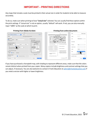
Printing from Adobe Acrobat: Printing from online document:
If you have purchased a choropleth map, with shading to represent different areas, make sure that the colors
remain distinct when printed from your copier. Many copiers include brightness and contrast settings that you
can adjust, if necessary. You are also welcome to contact C Frank Education at admin@cfrankeducation.com if
you need a version with higher or lower brightness.
- 2. © C Frank Education, 2022
Name: _____________________________
Map Skills Worksheet: Using Scale & the Compass Rose
1. What is the scale of this map?
2. Use the scale to fill out the chart below:
𝟏
𝟐
inch on the map equals
_____
mile(s) in real life
1 inch on the map equals
_____
mile(s) in real life
2 inches on the map equal
_____
mile(s) in real life
5 inches on the map equal
_____
mile(s) in real life
3. How far away is Harrisburg from Mt.
Perry?
4. How far away is Harrisburg from Davis?
5. How many miles would it take to drive
from Harrisburg to Davis without using a
highway?
6. What is the capital of New Manshire?
7. Which highway is more likely to have a
bridge? (Highway numbers are in the
symbols)
8. Which forest is farthest east?
9. Is Mt. Perry north or south of Surry?
10.Is Mt. Perry southeast or southwest of
Lowell?
- 3. © C Frank Education, 2022
MAP SKILLS WORKSHEET – ANSWER KEY – TEACHER RESOURCE
Map Skills Worksheet: Using Scale & the Compass Rose
1. What is the scale of this map?
1 in = 4 mile
2. Use the scale to fill out the chart below:
𝟏
𝟐
inch on the map equals 2 mile(s) in real life
1 inch on the map equals 4 mile(s) in real life
2 inches on the map equal 8 mile(s) in real life
5 inches on the map equal 20 mile(s) in real life
3. How far away is Harrisburg from Mt.
Perry?
6 miles
4. How far away is Harrisburg from Davis?
4 miles
5. How many miles would it take to drive
from Harrisburg to Davis without using a
highway?
6 miles
6. What is the capital of New Manshire?
Lowell
7. Which highway is more likely to have a
bridge? (Highway numbers are in the
symbols)
Highway 125
8. Which forest is farthest east?
Tinsel Forest
9. Is Mt. Perry north or south of Surry?
South
10.Is Mt. Perry southeast or southwest of
Lowell?
Southwest
- 4. © C Frank Education, 2022
MAP SKILLS WORKSHEET – DATA TRACKER – TEACHER RESOURCE
Homeroom: __________________________________ Date: ___________________
Student Name:
Mark each incorrect question with an X
Score:
1. 2. 3. 4. 5. 6. 7. 8. 9. 10.
1.
2.
3.
4.
5.
6.
7.
8.
9.
10.
11.
12.
13.
14.
15.
16.
17.
18.
19.
20.
21.
22.
23.
24.
25.
26.
27.
28.
29.
30.
31.
32.
- 5. © C Frank Education, 2022
MAP SKILLS WORKSHEET – STANDARDS – TEACHER RESOURCE
Here is a generalized set of 15 standards for map skills, to use when data tracking. The standards reviewed in this
worksheet are highlighted. You are welcome to use this set of standards, or find equivalent skills in your state standards:
Map Features [F]
I. Identify components of a map:
a. Title
b. Legend / Key
c. Scale
d. Compass Rose
e. Coordinate Grid
f. Inset Map / Locator Map
Relative Location [L]
II. Apply key/legend symbols to determine what is shown on a map
III. Identify a location in a neighborhood, city, state, country, continent, and the world
IV. Describe relative location using cardinal directions
a. Complete compass rose when provided with the North direction
b. Be able to use Northeast, Northwest, Southeast, Southwest
Map Grid [G]
V. Demonstrate ability to use grids to locate places on a map
a. Demonstrate ability to provide coordinates for a location on a map
b. Demonstrate command of longitude and latitude
Map Scale [S]
VI. Calculate distance using scale
a. Calculate distances that include half-units of measurement (eg, half inch)
Map Analysis [A]
VII. Draw conclusions based on the information represented on a map
a. Determine the causes and effects of man-made or natural geographic features on an area of land (eg,
with regards to wildlife, human settlement, transportation, economic activity, pollution)
b. Incorporate features of a political map in analysis of map information (eg, country borders)
VIII. Determine the uses of a map, including the creator’s purpose in including map details
a. Assess the role that the creator’s choices and/or bias (including map projection) has affected what is
represented on a map
Corroboration [C]
IX. Compare and contrast what is represented on two or more maps
X. Integrate information from print or digital texts in analysis of maps
XI. Compare data representation on a map to a data table or chart
a. Explain advantages and disadvantages of representing data on a map
Real-World Knowledge [W]
XII. Locate home on a map of the world
XIII. Identify continents and oceans
XIV. Identify regions of the world
XV. Identify countries of the world
- 6. © C Frank Education, 2022
Thank you for your interest in this resource!
Scale and Compass Rose Map (#6)
I hope you enjoyed this FREE resource! To see more of what my store has to offer,
please check out the following:
o ALL Map Skills Worksheets
o Map Skills Worksheets – Calculating Scale
o Map Skills Worksheets – Using the Compass Rose
Looking to get more but spend less? Here’s a discounted bundle:
o 5 Scale & Compass Rose Worksheets BUNDLE
Suggested Facilitation Guide:
1. Print the student worksheet (page 2 of the document). Be sure to print the PDF as its actual size to
maintain scale – printing directions included.
2. Give students the worksheet as part of a guided lesson or independent work. These worksheets are
great for homework or as an in-class formative assessment.
3. Assess student progress using the 3 pages of Teacher Resources: Answer Key, Data Tracker, and Map
Skills Standards reference sheet. *The Data Tracker PDF has editable fields, so teachers can save, print,
and share soft copies of student data.
If you’ve used this resource, I’d love to hear how it went! Please comment
and rate this product, and follow my store!