Voyager is a feature available at the Google Earth site. It can be used to encourage learners to dive deeper into topic while providing learners with linkages to global locations. This guide introduces 3 different ways to use to explore indigenous peoples, lands and cultures.
This document provides guidance on using Google Earth and Google Maps for geography teaching at key stages 3 and 4. It includes skills sheets that explain how to navigate and use various tools in Google Earth like layers, measuring distance, and creating placemarks, paths, and polygons. Online resources are also listed for finding lessons and mapmaking tutorials.
The document provides information about plate tectonics and volcanic activity. It includes sections on Alfred Wegener and his theory of continental drift, the formation of supercontinents like Pangea, demonstrations of plate tectonics using Oreo cookies, the rock cycle, types of rocks, earthquakes and the Richter scale, making a model volcano, volcanic features, and tsunamis. The document contains images to label, questions to answer, and instructions for hands-on activities like creating an erupting volcano model using plaster of paris.
This document outlines a virtual tour lesson on volcanoes using Google Earth. Students will visit several famous volcanoes and complete a chart about each one. They will then choose one volcano to create an informational brochure or poster about to share what they learned. The lesson aims to help students recognize different volcano types, locations, and the geological processes that cause volcanic eruptions.
Google Earth allows users to view locations around the world, take virtual tours, and see driving directions. Additional features include viewing layers of information about places, 3D terrain modeling, and a flight simulator. The toolbar provides tools for navigation, zooming, and sharing content.
This is a worksheet that students can follow to familiarize themselves with the app google Expeditions. The worksheet provides learners guidance on how the App can be used as well as give them some responsibility to complete a basic task.
The document provides instructions for playing Geoguessr's Daily Challenge game. It explains how to create a free Geoguessr account, select the Daily Challenge game which presents 5 random global locations, view the Street View at each location to make guesses, pin guesses on the map, view results between guesses, and see performance summaries after completing all locations.
How To Microsoft Immersive Reader for Word2019John Allan
The document provides instructions for using the immersive reader feature in Microsoft Word 2019:
1. Open a Word document and click on the Immersive Reader icon under the View menu to launch the immersive reader interface.
2. The immersive reader toolbar appears and formats the text with smaller margins and more spacing to reduce distractions and focus on the text.
3. Various settings and display options can be adjusted within the immersive reader, such as reading speed and volume, line and page formatting, and visualizing syllables.
The document describes H5P's interactive book tool, which allows instructors to create interactive books with multiple pages of content. Students can access pages through a menu and each page has its own URL. The tool guides how to add a book cover, pages with different interactive content types, and display options. It also describes the student and teacher experience, with students completing interactive elements on pages and teachers able to view student attempts and reports.
H5P's Dictation tool allows instructors to set up listening and writing activities. An H5P dictation activity allows instructors to set up normal and slow audio for student consideration. As well, alternate spellings can be set up to ensure that students can use alternate spelling or numbers. An example of short dictation activity can be viewed https://h5p.org/dictation.
The document discusses business strategies and processes. It advocates for collaborative thinking to grow the holistic world view of disruptive innovation through workplace diversity. It also discusses capitalizing on opportunities, podcasting operational changes, and dynamically procurrastinating to draw convergence across platforms. Potential roadblocks like clicks-and-mortar solutions are addressed, as well as profiting through synergizing relationships and dynamically innovating customer service. Reflection on processes to predominate testing and engage web services is also provided.
The document provides step-by-step instructions for improving the accessibility of a Microsoft Word document. It details how to check for accessibility issues, customize text styles and structure, add alternative text descriptions to images and other non-text elements, format lists and tables for screen readers, and remove watermarks and add descriptive text to hyperlinks. The goal is to ensure the content can be understood when read aloud by a screen reader.
Qatar University Conference 2021 Interactive video W/ H5P SlidesJohn Allan
This document discusses creating interactive videos using H5P. It begins with acknowledging the traditional territories of Indigenous peoples. It then introduces John Allan and lists his credentials. The document outlines objectives to demonstrate interactive video features and generation using H5P. It provides an example H5P interactive video and lists other interactive video tools. It describes how to enhance videos with annotations, questions, and other interactions. It provides sources for finding H5P interactive videos and links to tutorials and documentation for creating them. In the end, it asks if the reader has any other questions.
This is How To document for teachers who are trying to improve their online and blended courses without purchasing complex software. Windows 10 arrives with the Photos Video Editor. It provides essential tools for teachers to edit their video for educational purposes.
This document provides instructions for editing audio files using the Audacity Online Editor Chrome Extension. It describes how to upload and import audio clips, select portions of audio to edit, add silence or apply effects like normalization and fading. Editing techniques covered include cropping, removing tracks, and using the envelope tool to adjust volume over time. The document explains how to export edited audio files from the online editor.
This is a revised session hand out that introduces the basics of image editing to educators. PIXLR Editor is used because, it is Free, intuitive and online.
This document discusses using Adobe InDesign for rapid development of instructor guides and student workbooks. It outlines how InDesign features like templates, master pages, styles, and libraries can help with consistency and reuse. The team used InDesign along with linked Creative Cloud apps like Illustrator, Photoshop, and Acrobat to lay out over 100 guides and workbooks for publishing online. Through templates, common elements, and collaboration tools in InDesign, the team was able to efficiently produce the materials despite having low experience.
Walmart Business+ and Spark Good for Nonprofits.pdfTechSoup
"Learn about all the ways Walmart supports nonprofit organizations.
You will hear from Liz Willett, the Head of Nonprofits, and hear about what Walmart is doing to help nonprofits, including Walmart Business and Spark Good. Walmart Business+ is a new offer for nonprofits that offers discounts and also streamlines nonprofits order and expense tracking, saving time and money.
The webinar may also give some examples on how nonprofits can best leverage Walmart Business+.
The event will cover the following::
Walmart Business + (https://business.walmart.com/plus) is a new shopping experience for nonprofits, schools, and local business customers that connects an exclusive online shopping experience to stores. Benefits include free delivery and shipping, a 'Spend Analytics” feature, special discounts, deals and tax-exempt shopping.
Special TechSoup offer for a free 180 days membership, and up to $150 in discounts on eligible orders.
Spark Good (walmart.com/sparkgood) is a charitable platform that enables nonprofits to receive donations directly from customers and associates.
Answers about how you can do more with Walmart!"
How to Setup Warehouse & Location in Odoo 17 InventoryCeline George
In this slide, we'll explore how to set up warehouses and locations in Odoo 17 Inventory. This will help us manage our stock effectively, track inventory levels, and streamline warehouse operations.
Main Java[All of the Base Concepts}.docxadhitya5119
This is part 1 of my Java Learning Journey. This Contains Custom methods, classes, constructors, packages, multithreading , try- catch block, finally block and more.
How to Fix the Import Error in the Odoo 17Celine George
An import error occurs when a program fails to import a module or library, disrupting its execution. In languages like Python, this issue arises when the specified module cannot be found or accessed, hindering the program's functionality. Resolving import errors is crucial for maintaining smooth software operation and uninterrupted development processes.
বাংলাদেশের অর্থনৈতিক সমীক্ষা ২০২৪ [Bangladesh Economic Review 2024 Bangla.pdf] কম্পিউটার , ট্যাব ও স্মার্ট ফোন ভার্সন সহ সম্পূর্ণ বাংলা ই-বুক বা pdf বই " সুচিপত্র ...বুকমার্ক মেনু 🔖 ও হাইপার লিংক মেনু 📝👆 যুক্ত ..
আমাদের সবার জন্য খুব খুব গুরুত্বপূর্ণ একটি বই ..বিসিএস, ব্যাংক, ইউনিভার্সিটি ভর্তি ও যে কোন প্রতিযোগিতা মূলক পরীক্ষার জন্য এর খুব ইম্পরট্যান্ট একটি বিষয় ...তাছাড়া বাংলাদেশের সাম্প্রতিক যে কোন ডাটা বা তথ্য এই বইতে পাবেন ...
তাই একজন নাগরিক হিসাবে এই তথ্য গুলো আপনার জানা প্রয়োজন ...।
বিসিএস ও ব্যাংক এর লিখিত পরীক্ষা ...+এছাড়া মাধ্যমিক ও উচ্চমাধ্যমিকের স্টুডেন্টদের জন্য অনেক কাজে আসবে ...
हिंदी वर्णमाला पीपीटी, hindi alphabet PPT presentation, hindi varnamala PPT, Hindi Varnamala pdf, हिंदी स्वर, हिंदी व्यंजन, sikhiye hindi varnmala, dr. mulla adam ali, hindi language and literature, hindi alphabet with drawing, hindi alphabet pdf, hindi varnamala for childrens, hindi language, hindi varnamala practice for kids, https://www.drmullaadamali.com
it describes the bony anatomy including the femoral head , acetabulum, labrum . also discusses the capsule , ligaments . muscle that act on the hip joint and the range of motion are outlined. factors affecting hip joint stability and weight transmission through the joint are summarized.
Beyond Degrees - Empowering the Workforce in the Context of Skills-First.pptxEduSkills OECD
Iván Bornacelly, Policy Analyst at the OECD Centre for Skills, OECD, presents at the webinar 'Tackling job market gaps with a skills-first approach' on 12 June 2024
A review of the growth of the Israel Genealogy Research Association Database Collection for the last 12 months. Our collection is now passed the 3 million mark and still growing. See which archives have contributed the most. See the different types of records we have, and which years have had records added. You can also see what we have for the future.
This presentation was provided by Steph Pollock of The American Psychological Association’s Journals Program, and Damita Snow, of The American Society of Civil Engineers (ASCE), for the initial session of NISO's 2024 Training Series "DEIA in the Scholarly Landscape." Session One: 'Setting Expectations: a DEIA Primer,' was held June 6, 2024.
Pollock and Snow "DEIA in the Scholarly Landscape, Session One: Setting Expec...
Google Earth Voyager How To
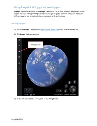
1. John Allan 2023
Using Google Earth Voyager – three Voyages
Voyager is a feature available at the Google Earth site. It can be used to encourage learners to dive
deeper into topic while providing learners with linkages to global locations. This guide introduces
different ways to use to explore indigenous peoples, lands and cultures.
Starting Voyager
1) Go to the Google Earth by typing https://earth.google.com in the browser address bar.
2) The Google Earth app appears.
3) In the left column of the screen, click on the Voyager icon.
2. John Allan 2023
Note: A slider rotating between 5 voyages appears.
Note: The Voyager menu appears under the slider. Each of these options has potential for
learners. Take your time to see what they offer. Choose one of these to open a Google Earth
voyage. In this example we will go to the Celebrating Indigenous Language voyage.
Voyage 1) Celebrating Indigenous Languages
1) The Voyager menu choose the menu link, Culture.
Note: Several topic options appear in poster format.
2) Scroll down the page until you see the Celebrating Indigenous Languages poster.
3) Click on the Celebrating Indigenous Languages poster.
Note: A split screen appears with the globe with red points on the left and an information panel
on the right.
3. John Allan 2023
4) Drag on the globe to rotate it.
Note: The Google Earth navigation feature work in Voyager.
5) In the panel, read the introductory text.
6) In this voyage, click on the Play button to watch the introductory video.
7) After the video is over, close the video.
8) Click on the Explore button to start learning about indigenous languages.
Note: There are 84 languages to explore.
4. John Allan 2023
9) The first language screen appears. The globe zooms into a satellite view of a related living space.
Note: The red pointer.
10) The perspectives and scale of this image can be altered by the Google Earth Viewing
controllers.
11) Above the text, there is a picture of a person and an audio clip of a person providing authentic
language responding to three prompts such as how do you greet people in your language? Click on
the Play button to hear the response in indigenous language.
12) Just under the highlighted person’s picture is the name of the language, the person’s name, the
nation’s name and their location.
5. John Allan 2023
13) Below the audio player is a description of the person pictured and their current situation.
14) To move to the next language, click on the right chevron at the
bottom of the screen.
15) To get a global view to choose a language based on location. Double
click on the globe in the Google Earth View tools.
16) Move the globe, to a place that you want to examine, click on the red
pointer icon.
17) The language panel appears for the selected language.
18) Click on the Fly To icon to zoom in on the languages’ area if the globe is not pointing at the
current language’s location
.
19) After the languages have been viewed, click on the Voyager icon to return.
6. John Allan 2023
Voyage 2) Exploring an issue – Nature & Environment (deforestation example)
1) Go to the Google Earth by typing https://earth.google.com in the browser address bar.
2) The Google Earth app appears.
3) In the left column of the screen, click on the Voyager icon.
4) The Voyager menu appears at the bottom of the screen.
5) Choose the menu link, Layers.
Note: A several topic options appear in poster format.
6) Click on the link Timelapse in Google Earth.
Note: A split screen appears with a map on the left and a menu on the right.
7) Choose the Changing Forests option.
7. John Allan 2023
8) The first screen appears. The globe zooms into a satellite view of the related space.
9) The perspectives and scale of this image can be altered by the Google Earth Viewing
controllers.
10) In the top right side of the panel, there is a manually controlled slide show with more detailed
images.
11) Just under the slideshow is the name of the environmental situation/activity, and the location.
Click on the Play button to hear the response in indigenous language.
12) Below these is the timelapse timeline player.
8. John Allan 2023
13) To control the view, either press the Pause / Play button to control the time lapse or click on the
year.
14) Under the Timelapse player is a text description of the issue.
15) To move to the next timelapse, click on the right chevron at the bottom of the screen.
16) To get a global view to choose a deforestation point in the world, double click on the globe in
the Google Earth View tools.
17) Move the globe, to a place that you want to examine, click on the red pointer icon.
9. John Allan 2023
18) The panel appears for the selected area.
19) Click on the Fly To icon to zoom in on the area.
20) After the languages have been viewed, click on the Voyager icon to return.
Similar activities:
• Tokyo’s Heat Island Effect
• Fragile Beauty
• Sources of Energy
• Warning Planet
• Urban Expansion
• Safeguarding Iconic Parks
• Bald Eagles Live
• Sea Level Rise and the Fate of Coastal Cities
• Tracking the Rain Bird
• Crab Migration on Christmas Island
• Women on the Front Lines of Conservation
• The Return of the Sea Otter
• See Climate Change’s Impact
• Waterways of Space
• Achieving Zero Landfill Waste in National Parks
• Exploring Earth’s Ecosystems
• Be a Scientist with Your Smartphone
• Ocean to Plate
• Reducing Plant Extinction
10. John Allan 2023
• Helping People and Animals Coexist
• Treks: Churchill, Manitoba
• Natural Treasures: Mountains
• Brown Bears of Katmai National Park, Alaska
• Clouds from Space
• Treks: The Canadian Arctic
• Natural Treasures: Islands
• The Arctic Life
• Dive Into the Planet with Jill Heinerth
• The Greatest Gatherings on Earth
Voyager 3) Tour Places – Street View (Discover Spain)
1) Go to the Google Earth by typing https://earth.google.com in the browser address bar.
2) The Google Earth app appears.
3) In the left column of the screen, click on the Voyager icon.
4) The Voyager menu appears at the bottom of the screen.
5) Choose the menu link, Street View.
6) Choose the resource, Discover Spain.
11. John Allan 2023
7) Click on the Let’s Go button.
8) The first screen appears. The globe zooms into a satellite view of the related space.
9) To have a ground level view of feature places in Spain, click on one of the icons in the Discover
Spain panel.
Note: Google Street View replaces the globe on the screen. There is a descriptive panel with several
areas to discover using the navigation arrows.
10) Click and drag on the screen to move around the first scene.
12. John Allan 2023
11) Click on the right chevron to go to the next areas to discover.
12) When you want to stop exploring, click on the Table of
contents icon.
13) To tour around another place, click on one of the icons in the Discover Spain panel.
14) After you have explored enough, click on the Voyager icon to return.