Spatial Narratives of the Historic Tibetan Capital of Lhasa with 3D GIS
•Télécharger en tant que PPTX, PDF•
1 j'aime•188 vues
Presentation delivered by Guoping Huang, Will Rourk and Kurtis Schaeffer on 2018-09-97 at the Rare Book School's Archives, Memory & Identity: A Public Symposium
Signaler
Partager
Signaler
Partager

Recommandé
Geospatial Archiving - Society of American Archivists
Maps tell stories and help people understand their relationship to place. They can be used to provide historical context on a local level and make spatial archives more accessible when combined with open, accessible data and tools for analysis. By enabling collaborative sharing, automatic metadata generation, and treating maps as social objects, more developers, researchers, organizations and citizens can analyze and contribute to our understanding of the built environment and human geography.
Linked Geo-Data and Early Geospatial Documents
Presentation about Pelagios at the Workshop "What's in a Place?" - Max Planck Institute for the History of Science, November 15, 2013.
Using Google Earth in the K-12 Classroom
Google Earth is a free program that allows users to virtually explore the globe using satellite imagery. It can be used across multiple disciplines in K-12 classrooms to strengthen technology skills and provide real world contexts for learning. Some ways it has been used include exploring geography by identifying landforms and using latitude and longitude, doing real world math problems, exploring various science topics, viewing historic maps and events, and examining life in different cities. Resources and examples of lessons and activities using Google Earth are provided.
Current events project script erica rodenschmit
Experts from the Documentation Centre of Cambodia are using ground-penetrating radar equipment and fieldwork to locate mass graves from the Khmer Rouge era in Prey Veng, Cambodia from November 2018 in order to determine the number of bodies and potentially help locate family members or ancestors of those killed during the regime.
Ancient greece flowchart
Ancient Greece was known for its architecture like temples and pillars. It produced famous sculptures and pottery. The region had a mountainous landscape and many city-states like Athens. Greek mythology featured supernatural beings like Zeus, Hades and Poseidon. Society was divided into citizens, non-citizens and slaves. Notable philosophers included Socrates, Plato and Aristotle. Greece experienced important wars and periods of history. The Olympics were a religious sporting event held every four years dedicated to Zeus.
Hestia+Pelagios @ the 2019 meeting of the Society for Classical Studies
Presentation on Hestia and Pelagios at the 2019 meeting of the Society for Classical Studies in San Diego
Teaching with Google Earth
Examples of how a faculty member can teach with Google Earth. The slides towards the end were combined with showing that place in Google Earth.
Proceedings for 2016 WV EPAN GIS Users Group Meeting
The annual Eastern WV Panhandle GIS Users Group Forum was held on September 14th, 2016 with 51 people attending. The one-day conference was organized by a committee from Jefferson County GIS and included sponsors from the WV Association of Geospatial Professionals and Eastern Panhandle Regional Planning and Development Council. Speakers presented on topics such as implementing parcel fabric in WV, using GIS for regional economic development, trends in GIS tools, integrating survey data into GIS, local contributions to state/federal datasets, evaluating riparian buffers, GIS for field mobility, and high accuracy data collection. Follow up contact information was provided for Jefferson County WV GIS.
Hass Week Resources Infographic
This document provides a list of resources for teaching humanities and social sciences subjects. It includes links to organizations that provide curriculum resources on topics like Asia literacy, Aboriginal and Torres Strait Islander histories and cultures, sustainability, civics and citizenship. The resources cover a range of subjects and year levels and are intended to support teaching the WA curriculum.
Dumbacher d
The National Aeronautics and Space Administration's (NASA) Human Exploration and Operations (HEO) Mission Directorate oversees human spaceflight programs including Orion, the Space Launch System (SLS), and Commercial Crew vehicles. HEO supports research and development for human exploration through programs like the Human Research Program and Advanced Exploration Systems. The directorate also provides space and flight support for critical technology projects at centers like Goddard Space Flight Center.
Mathematician timeline
The document provides a timeline of important mathematicians from Thales of Miletus in the 7th-6th century BC to Srinivasa Ramanujan in the early 20th century. It notes some of their key accomplishments, such as Thales of Miletus using geometry to measure heights and distances and being regarded as the first philosopher in the Greek tradition, and Pythagoras traveling widely seeking knowledge and influencing Plato. It also includes Euclid, Archimedes, Kepler, Newton, Gauss, and Einstein as major figures in the development of mathematics over the centuries.
WV Geo Explorer Project (epan 2011)
The document summarizes the goals and components of the West Virginia GeoExplorer project. The project aims to digitize historic maps of West Virginia, create an online reference library and searchable database, and develop a website to host interactive map layers showing the evolution of historic resources over time. The website uses a content management system to allow collaboration on pages and GIS tools. It provides access to digitized maps, books, and photos in an online map gallery and database for researchers.
Flyer 5th congress asia pacific_2015_english
This document provides information about the 5th Congress of Asian & the Pacific Studies to be held in September 2015 in Paris. It specifically outlines the panel on East Asian archaeology, including sessions on the material and funerary cultures of early East Asian polities. The first session focuses on the southern interaction sphere, with three presentations on burial systems in northern Kyushu, Japan and their connection to Korea, a comparative study of ancient wooden eating utensils between Korea and Japan, and the horse as a symbol between this world and the next in Kofun period Japan. The second session examines the northern interaction sphere, with talks on the mixed mortuary furnishings of Han period tombs in North Korea, differences in roof tile production
I ♥ Maps: Quantum GIS + Python
Quantum GIS (QGIS) is an open-source, highly customizable geospatial application that's great for data exploration, manipulation, and cartographic preparation -- in other words, it's software that allows you to make detailed, aesthetically-pleasing maps for free!
QGIS is also *extremely* script-able with Python, and integrates with a large number of database and analysis backends (GRASS, R, PostGIS, etc.). In this talk, Paige Bailey will be giving a short overview of QGIS; detailing a few mapping case studies; then showing how to leverage additional functionality by writing custom Python plugins.
Sahana : Case Studies (SahanaCamp 1.2)
Sahana was used in several disaster response efforts:
- In Haiti (2010) it managed missing persons, maps, organizations and hospitals. It also powered a food request portal for the WFP.
- In Pakistan floods (2010) it implemented new models and features but faced challenges with lack of baseline data, translation and SMS infrastructure.
- In Veracruz, Mexico (2010) setup went smoothly and ownership of the data was given to local organizations, while infrastructure support was provided.
- It also developed a portal to coordinate DRR projects for disaster preparedness organizations.
Teaching Tanach With Online Media
This document provides suggestions for using online media to teach Tanach (Bible). It lists examples like manipulating text, projecting maps, and using multimedia content. Several websites are recommended as resources for online text, maps, exciting multimedia lessons, and audio/visual materials. An example is given of having students do projects using a webquest template to further explore topics from Tanach.
Open Historical Maps at State of the Map (SOTM), 2009, Amsterdam
This document discusses tools and projects for digitizing and georeferencing historical maps on the web in an open and collaborative manner. It presents examples like Gutenkarte for browsing geographic texts, and the NYPL Map Rectifier and Digitizer. It also covers best practices for public editing, versioning, and resolving disputes on collaborative projects. Finally, it promotes open access to historical maps and building a shared database through crowd-sourcing with tools like Whooms and Mapwarper.
IAF Dr. Christian Feichtinger Presentation at Galaxy Forum China 2018
The document summarizes the International Astronautical Federation (IAF) Galaxy Forum held in Beijing, China in December 2018. The IAF connects 366 member organizations in 68 countries working in space exploration. It encourages international cooperation and knowledge sharing to advance space exploration for the benefit of humanity. Recent IAF events discussed increasing international focus on returning humans to the Moon and explored planned lunar missions by countries and agencies like the US, China, India, Russia, Europe, Israel, Japan, and South Korea throughout the 2020s.
History Connected
A presentation on how museums, libraries and archives (memory organizations) deliver public history using Interactive Communications Technologies in a world of always connected Internet users.
Anderson SAA 2014 Using CRM Data for "Big Picture" Research
David G. Anderson (University of Tennessee) presented his paper, “Using CRM Data for ‘Big Picture’ Research,” at the 79th annual meeting of the Society for American Archaeology in Austin, TX, in April 2014. This paper details the importance of CRM research in the development of Archaeology over the last forty years. Giving credit to the hundreds of thousands of technical reports and other forms of archaeological data stemming from ever-increasing amounts of CRM research in the Southeast, Anderson says this is the basis on which big picture research can now be accomplished. As technology and storage have caught up with the massive scale of new archaeological questions, digital repositories like DINAA can be utilized as highly effective tools.
History of the future
The document provides a brief history of key developments in research communication and e-scholarship from 1987 to 2017, including the emergence of new formats for research papers, tools to support workflows and provenance, treating data and software as first-class objects, new models of evaluation and peer review, roles for libraries, and business models. It notes several important milestones like the creation of the web, emergence of preprint archives and open access, as well as tools and standards that have advanced how research is conducted, shared, and evaluated.
Oah Panel 2010
The University of Virginia Library Geospatial Data Portal provides a suite of open-source tools to enable spatial scholarship by addressing difficulties like complex software, discovery of maps and data, and lack of metadata. The portal allows for rich metadata and multiple modes of access to geospatial data. Looking forward, NEH-funded projects like Neatline and the Institute for Enabling Geospatial Scholarship will further enhance spatial research.
2013 gis, gil and libraries… mapping in the digital age
Presented at a ICTLIG, LIASA event on 8 July 2013. This talk introduces the concept of the Geographic Information Systems (GIS) Librarian within the context of Geographic Information Librarianship to an audience comprised of South African Librarians.
Geospatial Outreach and Support at Stanford University - Julie Sweetkind-Sing...
This document summarizes geospatial support at Stanford University. It describes the university's centers for spatial research, technical infrastructure including software and computing resources, courses that teach geospatial concepts, and outreach activities. It also profiles several key staff who provide geospatial support and instruction to academics across many departments.
Crowdsourcing as productive engagement with cultural heritage
My keynote for the iSay conference "The Shape of Things"
http://isayevents.wordpress.com/shapeofthings/program/
My notes from the conference are at http://openobjects.blogspot.co.uk/2013/02/notes-from-shape-of-things-new-and.html
Data For Evil(?)
1) Two classics professors at King's College London collected data on ancient Greco-Roman heritage sites in Libya prior to the 2011 civil war to document cultural heritage.
2) This data was passed to NATO and the UK Ministry of Defense to help reduce damage to heritage sites from bombing during the conflict.
3) Unfortunately, while much of the sites avoided bombing, they were later vandalized during the ongoing civil war, demonstrating how data collected for good purposes could still enable harm depending on who accesses and uses it.
Wikimaps presentation at Iberoconf 2014
Wikimaps is a project that aims to bring historical maps into Wikimedia Commons and extract geodata from them. It focuses on opportunities for location-based storytelling. The document discusses tools being developed for Wikimaps, including an improved interface for the Warper tool and continued development of OpenHistoricalMap. It also describes potential areas of focus such as placing photographs in geographic and historical context, creating a historical gazetteer, and enabling microcontributions and storytelling tools. Furthermore, the document proposes the idea of "Wikimaps Expeditions" to collaboratively engage in mapping, documentation and storytelling about historical locations.
Your digital humanities are in my library! No, your library is in my digital ...
A presentation on the intersection of libraries and digital humanities presented at the Utah Digital Humanities Symposium at Utah Valley University on February 26, 2016.
Your digital humanities are in my library! No, your library is in my digital ...
Presentation at the Utah Digital Humanities Symposium at Utah Valley University on February 26, 2016.
Big Data in the Arts and Humanities: Stirling presentation
Slides from presentation to Literature and Languages Research Seminar, University of Stirling, 17 February 2016
Contenu connexe
Tendances
Hass Week Resources Infographic
This document provides a list of resources for teaching humanities and social sciences subjects. It includes links to organizations that provide curriculum resources on topics like Asia literacy, Aboriginal and Torres Strait Islander histories and cultures, sustainability, civics and citizenship. The resources cover a range of subjects and year levels and are intended to support teaching the WA curriculum.
Dumbacher d
The National Aeronautics and Space Administration's (NASA) Human Exploration and Operations (HEO) Mission Directorate oversees human spaceflight programs including Orion, the Space Launch System (SLS), and Commercial Crew vehicles. HEO supports research and development for human exploration through programs like the Human Research Program and Advanced Exploration Systems. The directorate also provides space and flight support for critical technology projects at centers like Goddard Space Flight Center.
Mathematician timeline
The document provides a timeline of important mathematicians from Thales of Miletus in the 7th-6th century BC to Srinivasa Ramanujan in the early 20th century. It notes some of their key accomplishments, such as Thales of Miletus using geometry to measure heights and distances and being regarded as the first philosopher in the Greek tradition, and Pythagoras traveling widely seeking knowledge and influencing Plato. It also includes Euclid, Archimedes, Kepler, Newton, Gauss, and Einstein as major figures in the development of mathematics over the centuries.
WV Geo Explorer Project (epan 2011)
The document summarizes the goals and components of the West Virginia GeoExplorer project. The project aims to digitize historic maps of West Virginia, create an online reference library and searchable database, and develop a website to host interactive map layers showing the evolution of historic resources over time. The website uses a content management system to allow collaboration on pages and GIS tools. It provides access to digitized maps, books, and photos in an online map gallery and database for researchers.
Flyer 5th congress asia pacific_2015_english
This document provides information about the 5th Congress of Asian & the Pacific Studies to be held in September 2015 in Paris. It specifically outlines the panel on East Asian archaeology, including sessions on the material and funerary cultures of early East Asian polities. The first session focuses on the southern interaction sphere, with three presentations on burial systems in northern Kyushu, Japan and their connection to Korea, a comparative study of ancient wooden eating utensils between Korea and Japan, and the horse as a symbol between this world and the next in Kofun period Japan. The second session examines the northern interaction sphere, with talks on the mixed mortuary furnishings of Han period tombs in North Korea, differences in roof tile production
I ♥ Maps: Quantum GIS + Python
Quantum GIS (QGIS) is an open-source, highly customizable geospatial application that's great for data exploration, manipulation, and cartographic preparation -- in other words, it's software that allows you to make detailed, aesthetically-pleasing maps for free!
QGIS is also *extremely* script-able with Python, and integrates with a large number of database and analysis backends (GRASS, R, PostGIS, etc.). In this talk, Paige Bailey will be giving a short overview of QGIS; detailing a few mapping case studies; then showing how to leverage additional functionality by writing custom Python plugins.
Sahana : Case Studies (SahanaCamp 1.2)
Sahana was used in several disaster response efforts:
- In Haiti (2010) it managed missing persons, maps, organizations and hospitals. It also powered a food request portal for the WFP.
- In Pakistan floods (2010) it implemented new models and features but faced challenges with lack of baseline data, translation and SMS infrastructure.
- In Veracruz, Mexico (2010) setup went smoothly and ownership of the data was given to local organizations, while infrastructure support was provided.
- It also developed a portal to coordinate DRR projects for disaster preparedness organizations.
Teaching Tanach With Online Media
This document provides suggestions for using online media to teach Tanach (Bible). It lists examples like manipulating text, projecting maps, and using multimedia content. Several websites are recommended as resources for online text, maps, exciting multimedia lessons, and audio/visual materials. An example is given of having students do projects using a webquest template to further explore topics from Tanach.
Open Historical Maps at State of the Map (SOTM), 2009, Amsterdam
This document discusses tools and projects for digitizing and georeferencing historical maps on the web in an open and collaborative manner. It presents examples like Gutenkarte for browsing geographic texts, and the NYPL Map Rectifier and Digitizer. It also covers best practices for public editing, versioning, and resolving disputes on collaborative projects. Finally, it promotes open access to historical maps and building a shared database through crowd-sourcing with tools like Whooms and Mapwarper.
IAF Dr. Christian Feichtinger Presentation at Galaxy Forum China 2018
The document summarizes the International Astronautical Federation (IAF) Galaxy Forum held in Beijing, China in December 2018. The IAF connects 366 member organizations in 68 countries working in space exploration. It encourages international cooperation and knowledge sharing to advance space exploration for the benefit of humanity. Recent IAF events discussed increasing international focus on returning humans to the Moon and explored planned lunar missions by countries and agencies like the US, China, India, Russia, Europe, Israel, Japan, and South Korea throughout the 2020s.
Tendances (10)
Open Historical Maps at State of the Map (SOTM), 2009, Amsterdam
Open Historical Maps at State of the Map (SOTM), 2009, Amsterdam
IAF Dr. Christian Feichtinger Presentation at Galaxy Forum China 2018
IAF Dr. Christian Feichtinger Presentation at Galaxy Forum China 2018
Similaire à Spatial Narratives of the Historic Tibetan Capital of Lhasa with 3D GIS
History Connected
A presentation on how museums, libraries and archives (memory organizations) deliver public history using Interactive Communications Technologies in a world of always connected Internet users.
Anderson SAA 2014 Using CRM Data for "Big Picture" Research
David G. Anderson (University of Tennessee) presented his paper, “Using CRM Data for ‘Big Picture’ Research,” at the 79th annual meeting of the Society for American Archaeology in Austin, TX, in April 2014. This paper details the importance of CRM research in the development of Archaeology over the last forty years. Giving credit to the hundreds of thousands of technical reports and other forms of archaeological data stemming from ever-increasing amounts of CRM research in the Southeast, Anderson says this is the basis on which big picture research can now be accomplished. As technology and storage have caught up with the massive scale of new archaeological questions, digital repositories like DINAA can be utilized as highly effective tools.
History of the future
The document provides a brief history of key developments in research communication and e-scholarship from 1987 to 2017, including the emergence of new formats for research papers, tools to support workflows and provenance, treating data and software as first-class objects, new models of evaluation and peer review, roles for libraries, and business models. It notes several important milestones like the creation of the web, emergence of preprint archives and open access, as well as tools and standards that have advanced how research is conducted, shared, and evaluated.
Oah Panel 2010
The University of Virginia Library Geospatial Data Portal provides a suite of open-source tools to enable spatial scholarship by addressing difficulties like complex software, discovery of maps and data, and lack of metadata. The portal allows for rich metadata and multiple modes of access to geospatial data. Looking forward, NEH-funded projects like Neatline and the Institute for Enabling Geospatial Scholarship will further enhance spatial research.
2013 gis, gil and libraries… mapping in the digital age
Presented at a ICTLIG, LIASA event on 8 July 2013. This talk introduces the concept of the Geographic Information Systems (GIS) Librarian within the context of Geographic Information Librarianship to an audience comprised of South African Librarians.
Geospatial Outreach and Support at Stanford University - Julie Sweetkind-Sing...
This document summarizes geospatial support at Stanford University. It describes the university's centers for spatial research, technical infrastructure including software and computing resources, courses that teach geospatial concepts, and outreach activities. It also profiles several key staff who provide geospatial support and instruction to academics across many departments.
Crowdsourcing as productive engagement with cultural heritage
My keynote for the iSay conference "The Shape of Things"
http://isayevents.wordpress.com/shapeofthings/program/
My notes from the conference are at http://openobjects.blogspot.co.uk/2013/02/notes-from-shape-of-things-new-and.html
Data For Evil(?)
1) Two classics professors at King's College London collected data on ancient Greco-Roman heritage sites in Libya prior to the 2011 civil war to document cultural heritage.
2) This data was passed to NATO and the UK Ministry of Defense to help reduce damage to heritage sites from bombing during the conflict.
3) Unfortunately, while much of the sites avoided bombing, they were later vandalized during the ongoing civil war, demonstrating how data collected for good purposes could still enable harm depending on who accesses and uses it.
Wikimaps presentation at Iberoconf 2014
Wikimaps is a project that aims to bring historical maps into Wikimedia Commons and extract geodata from them. It focuses on opportunities for location-based storytelling. The document discusses tools being developed for Wikimaps, including an improved interface for the Warper tool and continued development of OpenHistoricalMap. It also describes potential areas of focus such as placing photographs in geographic and historical context, creating a historical gazetteer, and enabling microcontributions and storytelling tools. Furthermore, the document proposes the idea of "Wikimaps Expeditions" to collaboratively engage in mapping, documentation and storytelling about historical locations.
Your digital humanities are in my library! No, your library is in my digital ...
A presentation on the intersection of libraries and digital humanities presented at the Utah Digital Humanities Symposium at Utah Valley University on February 26, 2016.
Your digital humanities are in my library! No, your library is in my digital ...
Presentation at the Utah Digital Humanities Symposium at Utah Valley University on February 26, 2016.
Big Data in the Arts and Humanities: Stirling presentation
Slides from presentation to Literature and Languages Research Seminar, University of Stirling, 17 February 2016
SEA CHANGE @ DM2Efinal conference, Pisa, Dec 11
Results from the Open Humanities Awards SEACHANGE project, presented at the DM2E final conference in Pisa, December 11, 2014.
07 dm2 e_seachange
Open Humanities Awards Open track: SEA CHANGE (Rainer Simon – AIT Austrian Institute of Technology) at Enabling humanities research in the Linked Open Web – DM2E final event (11 December 2014, Navacchio, Italy)
Tripcevich_CV
This document provides a summary of Nicholas Tripcevich's educational background and professional experience. It outlines that he received his Ph.D. in Anthropology from UC Santa Barbara in 2007, and has since held positions at UC Berkeley including as the Laboratory Manager of the Archaeological Research Facility. His research interests involve social complexity, Andean interaction, lithic analysis, and GIS applications. He has led several field projects in Peru focusing on obsidian sources and quarrying, and has over 15 peer-reviewed publications on related topics.
Your digital humanities are in my library! No, your library is in my digital ...
This document summarizes how libraries support and engage with digital humanities projects in three key ways:
1) Libraries offer resources like physical space, digitization services, server space, and librarian expertise to support digital humanities projects.
2) Case studies show specific digital humanities projects libraries have collaborated on, such as Chronicling America and a collaboration between UCLA and the Getty Research Institute.
3) Emerging trends in how libraries further support digital humanities are explored, such as through linked open data, digital library objects, multiple access points to data, and taking on roles in data management and curation.
GHY101 Unit 3.1c Geography of Buddhism
Slideshow on “the Geography of Buddhism” for World Regional Geography – © Mark M. Miller, Dept. of Geography & Geology, The University of Southern Mississippi
History connectedonlineapr2010
Rose Sherman from the Minnesota Historical Society presented on opportunities for connecting history online. She discussed digitizing collections and making them accessible online through research databases and stories told via websites and podcasts. Sherman also covered engaging users through crowdsourcing content like user-generated stories, videos, comments and mashups. Emerging technologies like location-aware mobile devices and virtual worlds provide new ways to experience history. Collaborative efforts allow users to participate in history through activities like annotating documents and editing wikis.
Visualizing the Past for the Present: A Summation of Interdisciplinary Digita...
This document summarizes Ashley Richter's work using new technologies for cultural heritage visualization in archaeology. It discusses how Richter uses 3D scanning and modeling to capture archaeological sites, and develops virtual and augmented reality applications to disseminate findings. It also describes Richter's role establishing an undergraduate research program at UCSD's Center for Interdisciplinary Science, where students gain experience applying technologies like scanning, imaging, and 3D printing to archaeological investigations in both land and underwater contexts. The document envisions these techniques comprising a new interdisciplinary field of "cultural heritage diagnostics."
Integrated Technology for Archaeological Imaging in the Field and in the Lab
Presented during a guest lecture at the University of California, Los Angeles, Cotsen Institute of Archaeology
Similaire à Spatial Narratives of the Historic Tibetan Capital of Lhasa with 3D GIS (20)
Anderson SAA 2014 Using CRM Data for "Big Picture" Research
Anderson SAA 2014 Using CRM Data for "Big Picture" Research
2013 gis, gil and libraries… mapping in the digital age
2013 gis, gil and libraries… mapping in the digital age
Geospatial Outreach and Support at Stanford University - Julie Sweetkind-Sing...
Geospatial Outreach and Support at Stanford University - Julie Sweetkind-Sing...
Crowdsourcing as productive engagement with cultural heritage
Crowdsourcing as productive engagement with cultural heritage
Your digital humanities are in my library! No, your library is in my digital ...
Your digital humanities are in my library! No, your library is in my digital ...
Your digital humanities are in my library! No, your library is in my digital ...
Your digital humanities are in my library! No, your library is in my digital ...
Big Data in the Arts and Humanities: Stirling presentation
Big Data in the Arts and Humanities: Stirling presentation
Your digital humanities are in my library! No, your library is in my digital ...
Your digital humanities are in my library! No, your library is in my digital ...
Visualizing the Past for the Present: A Summation of Interdisciplinary Digita...
Visualizing the Past for the Present: A Summation of Interdisciplinary Digita...
Integrated Technology for Archaeological Imaging in the Field and in the Lab
Integrated Technology for Archaeological Imaging in the Field and in the Lab
Dernier
Pengantar Penggunaan Flutter - Dart programming language1.pptx
Pengantar Penggunaan Flutter - Dart programming language1.pptx
Leveraging Generative AI to Drive Nonprofit Innovation
In this webinar, participants learned how to utilize Generative AI to streamline operations and elevate member engagement. Amazon Web Service experts provided a customer specific use cases and dived into low/no-code tools that are quick and easy to deploy through Amazon Web Service (AWS.)
BBR 2024 Summer Sessions Interview Training
Qualitative research interview training by Professor Katrina Pritchard and Dr Helen Williams
ISO/IEC 27001, ISO/IEC 42001, and GDPR: Best Practices for Implementation and...
Denis is a dynamic and results-driven Chief Information Officer (CIO) with a distinguished career spanning information systems analysis and technical project management. With a proven track record of spearheading the design and delivery of cutting-edge Information Management solutions, he has consistently elevated business operations, streamlined reporting functions, and maximized process efficiency.
Certified as an ISO/IEC 27001: Information Security Management Systems (ISMS) Lead Implementer, Data Protection Officer, and Cyber Risks Analyst, Denis brings a heightened focus on data security, privacy, and cyber resilience to every endeavor.
His expertise extends across a diverse spectrum of reporting, database, and web development applications, underpinned by an exceptional grasp of data storage and virtualization technologies. His proficiency in application testing, database administration, and data cleansing ensures seamless execution of complex projects.
What sets Denis apart is his comprehensive understanding of Business and Systems Analysis technologies, honed through involvement in all phases of the Software Development Lifecycle (SDLC). From meticulous requirements gathering to precise analysis, innovative design, rigorous development, thorough testing, and successful implementation, he has consistently delivered exceptional results.
Throughout his career, he has taken on multifaceted roles, from leading technical project management teams to owning solutions that drive operational excellence. His conscientious and proactive approach is unwavering, whether he is working independently or collaboratively within a team. His ability to connect with colleagues on a personal level underscores his commitment to fostering a harmonious and productive workplace environment.
Date: May 29, 2024
Tags: Information Security, ISO/IEC 27001, ISO/IEC 42001, Artificial Intelligence, GDPR
-------------------------------------------------------------------------------
Find out more about ISO training and certification services
Training: ISO/IEC 27001 Information Security Management System - EN | PECB
ISO/IEC 42001 Artificial Intelligence Management System - EN | PECB
General Data Protection Regulation (GDPR) - Training Courses - EN | PECB
Webinars: https://pecb.com/webinars
Article: https://pecb.com/article
-------------------------------------------------------------------------------
For more information about PECB:
Website: https://pecb.com/
LinkedIn: https://www.linkedin.com/company/pecb/
Facebook: https://www.facebook.com/PECBInternational/
Slideshare: http://www.slideshare.net/PECBCERTIFICATION
Chapter 4 - Islamic Financial Institutions in Malaysia.pptx
Chapter 4 - Islamic Financial Institutions in Malaysia.pptxMohd Adib Abd Muin, Senior Lecturer at Universiti Utara Malaysia
This slide is special for master students (MIBS & MIFB) in UUM. Also useful for readers who are interested in the topic of contemporary Islamic banking.
How to Manage Your Lost Opportunities in Odoo 17 CRM
Odoo 17 CRM allows us to track why we lose sales opportunities with "Lost Reasons." This helps analyze our sales process and identify areas for improvement. Here's how to configure lost reasons in Odoo 17 CRM
How to Setup Warehouse & Location in Odoo 17 Inventory
In this slide, we'll explore how to set up warehouses and locations in Odoo 17 Inventory. This will help us manage our stock effectively, track inventory levels, and streamline warehouse operations.
How to Create a More Engaging and Human Online Learning Experience
How to Create a More Engaging and Human Online Learning Experience Wahiba Chair Training & Consulting
Wahiba Chair's Talk at the 2024 Learning Ideas Conference. RHEOLOGY Physical pharmaceutics-II notes for B.pharm 4th sem students
Physical pharmaceutics notes for B.pharm students
How to Fix the Import Error in the Odoo 17
An import error occurs when a program fails to import a module or library, disrupting its execution. In languages like Python, this issue arises when the specified module cannot be found or accessed, hindering the program's functionality. Resolving import errors is crucial for maintaining smooth software operation and uninterrupted development processes.
The History of Stoke Newington Street Names
Presented at the Stoke Newington Literary Festival on 9th June 2024
www.StokeNewingtonHistory.com
বাংলাদেশ অর্থনৈতিক সমীক্ষা (Economic Review) ২০২৪ UJS App.pdf
বাংলাদেশের অর্থনৈতিক সমীক্ষা ২০২৪ [Bangladesh Economic Review 2024 Bangla.pdf] কম্পিউটার , ট্যাব ও স্মার্ট ফোন ভার্সন সহ সম্পূর্ণ বাংলা ই-বুক বা pdf বই " সুচিপত্র ...বুকমার্ক মেনু 🔖 ও হাইপার লিংক মেনু 📝👆 যুক্ত ..
আমাদের সবার জন্য খুব খুব গুরুত্বপূর্ণ একটি বই ..বিসিএস, ব্যাংক, ইউনিভার্সিটি ভর্তি ও যে কোন প্রতিযোগিতা মূলক পরীক্ষার জন্য এর খুব ইম্পরট্যান্ট একটি বিষয় ...তাছাড়া বাংলাদেশের সাম্প্রতিক যে কোন ডাটা বা তথ্য এই বইতে পাবেন ...
তাই একজন নাগরিক হিসাবে এই তথ্য গুলো আপনার জানা প্রয়োজন ...।
বিসিএস ও ব্যাংক এর লিখিত পরীক্ষা ...+এছাড়া মাধ্যমিক ও উচ্চমাধ্যমিকের স্টুডেন্টদের জন্য অনেক কাজে আসবে ...
Reimagining Your Library Space: How to Increase the Vibes in Your Library No ...
Librarians are leading the way in creating future-ready citizens – now we need to update our spaces to match. In this session, attendees will get inspiration for transforming their library spaces. You’ll learn how to survey students and patrons, create a focus group, and use design thinking to brainstorm ideas for your space. We’ll discuss budget friendly ways to change your space as well as how to find funding. No matter where you’re at, you’ll find ideas for reimagining your space in this session.
PCOS corelations and management through Ayurveda.
This presentation includes basic of PCOS their pathology and treatment and also Ayurveda correlation of PCOS and Ayurvedic line of treatment mentioned in classics.
Hindi varnamala | hindi alphabet PPT.pdf
हिंदी वर्णमाला पीपीटी, hindi alphabet PPT presentation, hindi varnamala PPT, Hindi Varnamala pdf, हिंदी स्वर, हिंदी व्यंजन, sikhiye hindi varnmala, dr. mulla adam ali, hindi language and literature, hindi alphabet with drawing, hindi alphabet pdf, hindi varnamala for childrens, hindi language, hindi varnamala practice for kids, https://www.drmullaadamali.com
How to deliver Powerpoint Presentations.pptx
"How to make and deliver dynamic presentations by making it more interactive to captivate your audience attention"
Main Java[All of the Base Concepts}.docx
This is part 1 of my Java Learning Journey. This Contains Custom methods, classes, constructors, packages, multithreading , try- catch block, finally block and more.
Dernier (20)
Pengantar Penggunaan Flutter - Dart programming language1.pptx
Pengantar Penggunaan Flutter - Dart programming language1.pptx
Leveraging Generative AI to Drive Nonprofit Innovation
Leveraging Generative AI to Drive Nonprofit Innovation
Digital Artefact 1 - Tiny Home Environmental Design
Digital Artefact 1 - Tiny Home Environmental Design
ISO/IEC 27001, ISO/IEC 42001, and GDPR: Best Practices for Implementation and...
ISO/IEC 27001, ISO/IEC 42001, and GDPR: Best Practices for Implementation and...
Chapter 4 - Islamic Financial Institutions in Malaysia.pptx
Chapter 4 - Islamic Financial Institutions in Malaysia.pptx
How to Manage Your Lost Opportunities in Odoo 17 CRM
How to Manage Your Lost Opportunities in Odoo 17 CRM
How to Setup Warehouse & Location in Odoo 17 Inventory
How to Setup Warehouse & Location in Odoo 17 Inventory
How to Create a More Engaging and Human Online Learning Experience
How to Create a More Engaging and Human Online Learning Experience
RHEOLOGY Physical pharmaceutics-II notes for B.pharm 4th sem students
RHEOLOGY Physical pharmaceutics-II notes for B.pharm 4th sem students
বাংলাদেশ অর্থনৈতিক সমীক্ষা (Economic Review) ২০২৪ UJS App.pdf
বাংলাদেশ অর্থনৈতিক সমীক্ষা (Economic Review) ২০২৪ UJS App.pdf
Reimagining Your Library Space: How to Increase the Vibes in Your Library No ...
Reimagining Your Library Space: How to Increase the Vibes in Your Library No ...
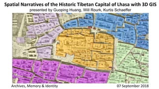
Spatial Narratives of the Historic Tibetan Capital of Lhasa with 3D GIS
- 1. Spatial Narratives of the Historic Tibetan Capital of Lhasa with 3D GIS presented by Guoping Huang, Will Rourk, Kurtis Schaeffer Archives, Memory & Identity 07 September 2018
- 2. Humanities Virtual Worlds Consortium Consortium Members: • University of Virginia • UCLA • National University of Ireland Maynooth • Indiana University UVA Lhasa VR Team: PI: David Germano & Kurtis Schaeffer Tech Lead: Will Rourk GIS Specialists: Guoping Huang Zihao Zhang Tibetan Specialists: Steve Weinberger Rinchen Dorje Tashi Dekyi Gar Ben Nourse Andres Montano Than Grove An Andrew Mellon Foundation Initiative
- 3. 3D and GIS Legacy http://bit.ly/MeruNyingpa
- 4. The 5th Dalai Lama (1617 – 1682)
- 7. USGS Data Declass II Satellite Imagery 1m resolution Acquired 1966/01/22 http://earthexplorer.usgs.gov GLSDEM_N029E090 & N029E091 90 M resolution http://srtm.csi.cgiar.org
- 8. ESRI ArcGIS
- 9. Pitt Rivers Tibetan Collection http://tibet.prm.ox.ac.uk Historic Media
- 12. Unity 3D
- 13. Lhasa VR http://bit.ly/LhasaVR Unity 3D and Drupal
- 15. http://www.nipic.com/ & Pitt River Museum
- 16. http://www.nipic.com/ & Pitt River Museum
- 17. Zhol Village covers 50,000 sq m. of the Potala Palace complex. It includes of 22 ancient buildings which cover an area of 33,470 sq m. These buildings once included housing as well as the city jail and government offices (for the city's administration, judiciary, revenue, and mint). Potala south face from Chakpori © Pitt Rivers Museum, University of Oxford http://www.nipic.com/ & Pitt River Museum
- 18. Guoping Huang School of Architecture ghuang@Virginia.edu Will Rourk University Library will@Virginia.edu Kurtis Schaeffer Religious Studies ks6bb@Virginia.edu