
Recommandé
Recommandé
Contenu connexe
En vedette
En vedette (8)
Similaire à Hgac commute solutions viewer
Similaire à Hgac commute solutions viewer (20)
Plus de Texas Natural Resources Information System
Plus de Texas Natural Resources Information System (20)
Dernier
Dernier (20)
Hgac commute solutions viewer
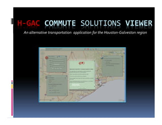
- 1. H-GAC COMMUTE SOLUTIONS VIEWER An alternative transportation application for the Houston-Galveston region
- 2. Overview Project Background Commute Solutions Program Collaboration Data Collection What is the ArcGIS Viewer for Flex? Implementation and Deployment Demo
- 3. Project Background H-GAC’s Air Quality group Focus on attaining the Clean Air Act air quality standards for the region Desired more of a public presence for its Commute Solutions program
- 4. Commute Solutions Program Partnership of H-GAC’s Regional Commute Alternatives Program, METRO, TxDOT, and several other Transportation Management Organizations (TMOs). Purpose is to provide a “one-stop” alternative transportation resource for both commuters and businesses
- 5. Commute Solutions Program Cont. Five Goals: Transport people in fewer vehicles Use transportation that does not contribute to congestion and pollution Reduce the number of people commuting during rush hours Reduce the number of single occupant vehicles Eliminate the need to commute to work
- 6. Agency Collaboration Assessed Agency Interest Requested Data for Participation Presented to Participating Entities and Regional members Entity feedback
- 7. Data Collection Met with Air Quality group and identified essential data for the application Sent requests to respective TMOs Formatted data and incorporated into Spatial Database Engine (SDE) Data issues Feedback
- 8. Data Collection Cont. • SDE feature class attributes • XML configuration file calling SDE attributes
- 9. Data Collection: Schedules • Collected transit schedules incorporated into application
- 10. ArcGIS Viewer for Flex Characteristics of the Viewer: Configurable application developed by ESRI Precompiled Customizable No written code required http://help.arcgis.com/en/webapps/flexviewer/
- 11. Implementation and Deployment SDE ArcGIS Server Web Server Configuration Files
- 13. Questions? Thanks! Application link: http://webgis2.h-gac.com/airquality/ Martin Siwek GIS Analyst & DBA Martin.Siwek@h-gac.com 832-681-2545