MYSTERY MOUNTAIN (II), WV
•Télécharger en tant que DOC, PDF•
1 j'aime•765 vues

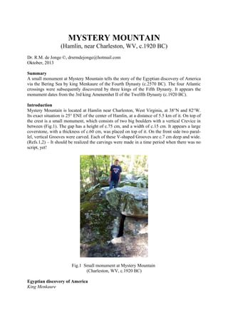
MYSTERY MOUNTAIN (Hamlin, near Charleston, WV, c.1920 BC) Dr. R.M. de Jonge ©, drsrmdejonge@hotmail.com Oktober, 2013 Summary A small monument at Mystery Mountain tells the story of the Egyptian discovery of America via the Bering Sea by king Menkaure of the Fourth Dynasty (c.2570 BC). The four Atlantic crossings were subsequently discovered by three kings of the Fifth Dynasty. It appears the monument dates from the 3rd king Amenemhet II of the Twelfth Dynasty (c.1920 BC).

Recommandé
Contenu connexe
Similaire à MYSTERY MOUNTAIN (II), WV
Similaire à MYSTERY MOUNTAIN (II), WV (20)
Plus de INSTITUTE OF MEGALITHIC RESEARCH
Dernier
Dernier (20)
MYSTERY MOUNTAIN (II), WV
- 1. MYSTERY MOUNTAIN (Hamlin, near Charleston, WV, c.1920 BC) Dr. R.M. de Jonge ©, drsrmdejonge@hotmail.com Oktober, 2013 Summary A small monument at Mystery Mountain tells the story of the Egyptian discovery of America via the Bering Sea by king Menkaure of the Fourth Dynasty (c.2570 BC). The four Atlantic crossings were subsequently discovered by three kings of the Fifth Dynasty. It appears the monument dates from the 3rd king Amenemhet II of the Twelfth Dynasty (c.1920 BC). Introduction Mystery Mountain is located at Hamlin near Charleston, West Virginia, at 38°N and 82°W. Its exact situation is 25° ENE of the center of Hamlin, at a distance of 5.5 km of it. On top of the crest is a small monument, which consists of two big boulders with a vertical Crevice in between (Fig.1). The gap has a height of c.75 cm, and a width of c.15 cm. It appears a large coverstone, with a thickness of c.60 cm, was placed on top of it. On the front side two parallel, vertical Grooves were carved. Each of these V-shaped Grooves are c.7 cm deep and wide. (Refs.1,2) – It should be realized the carvings were made in a time period when there was no script, yet! Fig.1 Small monument at Mystery Mountain (Charleston, WV, c.1920 BC) Egyptian discovery of America King Menkaure
- 2. The two vertical Grooves on the coverstone appear to refer to the 40th latitude line, 2° above Mystery Mountain, at 38+2= 40°N. It encodes the discovery of America in the Fourth Dynasty. In the Old World latitudes were already known c.4800 BC, as shown by the monument of Barnénez, Brittany, France. It happened at the southern Aleutian islands, at the south side of the Bering Sea, at the complementary latitude of 90-40= c.50°N by the 5th king Menkaure (Mycerinos, c.2580-2562 BC) of this dynasty. In antiquity the use of complementary latitudes was very common. From coast to coast the length of the 40th latitude line is 50° of longitude, which confirms this discovery by the 5th king, at c.50°N. The meridian, or north-south line of the Site crosses the Ohio River 1° higher, at 38+1= 39°N. The Crevice confirms it. The exact level of the southern Aleutian islands is provided by its complementary latitude, at 90-39= 50+1= 51°N. The holy Arctic Circle, at 67°N, is the northernmost line the Sun still shines at midwinter day (Sun religion). The Crevice shows king Menkaure returned via the Bering Strait, 1° below it, at 67-1= 66°N. This crossing is 66-51= 15° of latitude above the southern Aleutian islands. The two Grooves confirm this king discovered the two crossings between Asia and America. (Refs.3-6) Atlantic Crossings King Sahure The southern Cape Verde islands, off shore West Africa, are situated at 15°N (see above). The Nile Delta, at 30°N, encodes the sailing direction of the Southern Crossing, with the wind and the current, 30° SSW. The Crevice and the two Grooves form together three units, confirming it. The 50th latitude line, just mentioned, encodes the point of arrival, Cape São Roque (the Holy Rock), Brazil, at 5°S, as well as the Fifth Dynasty. The sailing distance of 2 Moiras, or 20°, encodes the 2nd king Sahure (c.2510-2498 BC), who discovered it. The two Grooves confirm this discovery by the 2nd king. This king had to return. Mystery Mountain is located at the level of the nine islands of the Azores in the middle of the Ocean, at 38°N. Its complementary latitude of 90-38= 50+2= 52°N confirms the 2nd king Sahure of the Fifth Dynasty. It shows he returned from Cape Race, the SE Cape of Newfoundland, 9° above Mystery Mountain, at 38+9= 47°N. The initial sailing direction, with the wind and the current, is 20° ESE and the sailing distance is 2 Moiras, or 20°, to the two islands of the West Azores. It is clear this crossing was discovered by this 2nd king. The two Grooves confirm it. The West Azores are located at 39°N, as indicated by the meridian of Mystery Mountain, which crosses the Ohio River at this latitude. The five islands of the Central Azores, at 38°N, confirm it happened in the Fifth Dynasty. These are located 50-38= 12° below the 50th latitude line, confirming his 12 years of reign. The two Grooves confirm the two southern crossings of the Ocean were discovered by the 2nd king Sahure of this dynasty. (Refs.7-11)
- 3. King Neferirkare The Nile Delta is located at 30°N. It encodes the Northern Crossing of the Ocean from the Shetland Islands, via the South Cape of Greenland, to Cape Chidley, Canada, at the complementary latitude of 90-30= 60°N. It was discovered by the 3rd king Neferirkare (c.2498-2478 BC). So, the third crossing of the Ocean was discovered by the 3rd king. The Crevice and the two Grooves form together three units, confirming it. The two Grooves confirm his 20 years of reign. King Unas The last discovered crossing starts at Abaco Island, northern Bahama’s, 3° below the Nile Delta, at 30-3= 27°N. The 2nd king Sahure reigned for 12 years. It shows the sailing distance to Bermuda, at 30+2= 32°N, was 12 moiras, or 12°. This island is located 9° above the holy Tropic of Cancer, at 23+9= 32°N. At midsummer day the Sun is there at right angles above (Sun religion). It shows the crossing from Bermuda to the nine islands of the Azores was discovered by the 9th and last king Unas (c.2403-2370 BC) of this dynasty. Mystery Mountain is located at the latitude of the three island groups of the Azores (the East, Central, and West Azores). The Crevice and the two Grooves form together three units, confirming it. These encode the long sailing distance from Bermuda to the Azores of 3 Moiras, or 30°. The 2nd king Sahure of the Fifth Dynasty sailed from the five islands of the Central Azores to the two islands of Madeira, at 38-5= 33°N. Their latitude encodes the 33 years of reign of king Unas (c.2403-2370 BC). He was the last king of the Fifth Dynasty! He discovered the island of Bermuda, 50-32= 18° below the 50th latitude line, confirming the 18 years of reign of king Menkaure (c.2580-2562 BC), who discovered America. (Refs.12-17)
- 4. Fig.2 The 5th king Menkaure (c.2580-2562 BC) of the Fourth Dynasty, who discovered America via the Bering Sea. (Boston Museum of Fine Arts) Religion The 18 years of reign of king Menkaure refer to the ancient civilization around the south point of the Gulf of Campeche, Mexico, at 18°N. It was the place where the Olmec civilization started, the holiest place of the America’s. It is the center of the Underworld, “the Realm of the Dead, at the other side of the waters (the Ocean), in the land where the Sun sets (America).” It is located at half the latitude of the Strait of Gibraltar, at 36/2= 18°N. It is the center of the Land of Punt, at a symbolic distance of half the circumference of the planet Earth, 18 Moiras, or 180° from the Land of the Living (Egypt). The ancient Egyptian “Book of the Dead” contains c.180 Spells for the Afterlife, confirming it. It is the oldest book on Earth. (Refs.18-33) Date North and South America were colonies of Egypt between 2500 and 1200 BC. Together, they formed the empire of Atlantis. It was the time period of the metal trade from America to the Old World. Copper from Upper Michigan and Isle Royale, and tin, silver and gold from Boli-via were shipped across the Ocean to the Mediterranean. Mystery Mountain dates from this time period. Mystery Mountain is located 50-38= 12° below the 50th latitude line, encoding the Twelfth Dynasty. It is situated at the latitude of the three island groups of the Azores, encoding the 3rd king Amenemhet II (c.1939-1905 BC). This archipelago extends over 2° of latitude, confirming his name. The meridian of MM leaves the west coast of south Florida 38-26= 12° below the site, which confirms the Twelfth Dynasty. It leaves this coast at 26°N, which refers to the capital of Thebes,
- 5. Egypt, at the “knee” of the River Nile during this dynasty. It hits the north coast of Cuba 26-23= 3° lower, confirming the 3rd king Amenemhet II. It crosses Florida Strait over 25-23= 2° of latitude, confirming his name. It hits Cuba at the holy Tropic of Cancer, at 23°N, which illustrates he is an Egyptian king. Far in the east this Tropic crosses the River Nile at the center of the Southern Egyptian Empire. However, this is also the center of the Sun religion. The sailing distance from Abaco Island to Bermuda was 12 moiras, or 12°, encoding the Twelfth Dynasty. Bermuda is located at 30+2= 32°N, encoding the 3rd king Amenemhet II. - The sailing distance to the two islands of the West Azores is 3 Moiras, or 30°, confirming the 3rd king Amenemhet II, again. (Refs.34-41) – Note, the Crevice and the two Grooves of the small monument at MM confirm the 3rd king Amenemhet II ! References 1. Molina, Y., FB Group: “Mystery Mountain, West Virginia” 2. Molina, Y., FB Group: “Ancient West Virginia: An Enigma” 3. De Jonge, R.M., and Wakefield, J.S., How the SunGod Reached America c.2500 BC, A Guide to Megalithic Sites, 2002 (ISBN 0-917054-19-9). Available: MCS Inc., Box 3392, Kirkland, Wa 98083, also on CD. Website: www.howthesungod.com 4. Wakefield, J.S., and De Jonge, R.M., Rocks & Rows, Sailing Routes across the Atlantic and the Copper Trade, MCS Inc, 2010 (ISBN 0-917054-20-2). Available: MCS Inc, Box 3392, Kirkland, Wa USA 98083. Website: www.rocksandrows.com 5. De Jonge, R.M., Website: www.slideshare.net/rmdejonge 6. Pellech, Chr., Website: www.migration-diffusion.info 7. De Jonge, R.M., “The Discovery of Three Continents (Santo Stefano, North Sardinia, Italy, c.2300 BC)”, Ancient American, Vol.12, No.76, pgs.28-29 (2007), Ref.5. 8. De Jonge, R.M., “Houghton’s Petroglyph (Copper Country, Michigan, 2500-1200 BC)” (2009), Ref.5. 9. De Jonge, R.M., “The Mystic Symbol, mark of the Michigan Mound Builders” (2009), Ref.5. 10. De Jonge, R.M., “A Sword for America (Kirkburn, East Yorkshire, England, c.250 BC)” (2009), Ref.5. 11. De Jonge, R.M., “The Battersea Shield (River Thames, London, c.190 BC)” (2009), Ref.5, to be published. 12. De Jonge, R.M., and Wakefield, J.S., “Discovery of the Islands in the Ocean (Cairn T, Loughcrew, Co. Meath, Ireland, c.3200 BC)” (2011), Ref.5. 13. De Jonge, R.M., and Wakefield, J.S., "The Passage Grave of Karleby, Encoding the Islands Discovered in the Ocean, c.2950 BC", Migration & Diffusion, Vol.5, No.18, pgs.64-74 (2004), Ref.6. 14. De Jonge, R.M., and Wakefield, J.S., "The Three Rivers Petroglyph, A Guide-post for River Travel in America", Migration & Diffusion, Vol.3, No.12, pgs.74-100 (2002), Ref.6. 15. De Jonge, R.M., and Wakefield, J.S., “A Nautical Center for Crossing the Ocean, America’s Stonehenge, New Hampshire, c.2200 BC”, Migration & Diffusion, Vol.4, No.15, pgs.60-100 (2003), Ref.6. 16. De Jonge, R.M., “Stonehenge, Monument for the Discovery of America (Salisbury Plain, South England, c.2000 BC)” (2011), Refs.5,6. 17. De Jonge, R.M., “Tripod Rock, Pyramid Mountain (Morris County, New Jersey, c.1900 BC)” (2011), Refs.5,6. 18. De Jonge, R.M., “The Comet Catastrophe of c.2345 BC”, (sixteen articles), Webpage: http://www.barry.warmkessel.com/dejonge.html 19. De Jonge, R.M., “Gold Ring (Grand Canyon, Arizona, c.1450 BC)” (2010), Ref.5. 20. De Jonge, R.M., “Sentinel Rock, Vermont (Discovery of America and Biblical Flood, c.1900 BC) ” (2011), Refs.5,6. 21. De Jonge, R.M., “Oil City Glyphs (Pennsylvania, c. 2000 BC)” (2012), Ref.5. 22. Rydholm, C.F., Michigan Copper, The Untold Story, Winter Cabin Books, Marquette, 2006 (ISBN 09744679-2-8). 23. De Jonge, R.M., “Megaliths of Arrowhead Region I (Minnesota, c.1900 BC)” (2012), Ref.5. 24. De Jonge, R.M., “Megaliths of Arrowhead Region II (Minnesota, c.1900 and c.770 BC BC)” (2012), Ref.5. 25. De Jonge, R.M., “Grave Creek Mound (I) (Moundville, Marshall County, WV)” (2012), Ref.5. 26. De Jonge, R.M., “Grave Creek Mound (II) (c.720 BC, Moundville, Marshall County, WV)” (2012), Ref.5. 27. De Jonge, R.M., “Copper Spear Tip, (Crow Wing County, MN, c.1500 BC)”, (2013), Ref.5. 28. De Jonge, R.M., “Ancient Stone Balls, (Redwood Co. and Stevens Co., MN, c.1900 BC)”, (2013), Ref.5.
- 6. 29. De Jonge, R.M., “Circle Cross Symbol, (Copper Harbor, Upper Michigan, c.1900 BC)”, (2013), Ref.5. 30. Faulkner, R.O., The Ancient Egyptian Book of the Dead, British Museum Press (2010) (ISBN 978-0-71411992-2). 31. Robin Mueller, FB Group: “Old Copper Complex and Ancient Waterways America”. 32. Susan English, Yahoo Group of the Ancient Waterways Society. 33. De Jonge, R.M., http://independent.academia.edu/ReinoudDeJonge 34. De Jonge, R.M., “Four Stone Chambers (I), (Crestone, Colorado, c.1900 BC)”, (2013), Refs.5,32,33. 35. De Jonge, R.M., “Four Stone Chambers (II), (Crestone, Colorado, c.1900 BC)”, (2013), Refs.5,32,33. 36. De Jonge, R.M., “Balanced Rock (I), (Buhl, Twin Falls County, Idaho)”, (2013), Refs.5,32,33. 37. De Jonge, R.M., “Balanced Rock (II), (Buhl, Twin Falls County, Idaho)”, (2013), Refs.5,32,33. 38. De Jonge, R.M., “Megalithic Writing (I), (Orkney’s, Scotland, c.2450 BC)”, (2013), Refs.5,32,33. 39. De Jonge, R.M., “Megalithic Writing (II), (Orkney’s, Scotland, c.2370 BC)”, (2013), Refs.5,32,33. 40. De Jonge, R.M., “Omak Rock (I), (Okanogan County, Washington, c.1900 BC)”, (2013), Refs.5,32,33. 41. De Jonge, R.M., “Omak Rock (II), (Okanogan County, Washington, c.1900 BC)”, (2013), Refs.5,32,33.
- 7. 29. De Jonge, R.M., “Circle Cross Symbol, (Copper Harbor, Upper Michigan, c.1900 BC)”, (2013), Ref.5. 30. Faulkner, R.O., The Ancient Egyptian Book of the Dead, British Museum Press (2010) (ISBN 978-0-71411992-2). 31. Robin Mueller, FB Group: “Old Copper Complex and Ancient Waterways America”. 32. Susan English, Yahoo Group of the Ancient Waterways Society. 33. De Jonge, R.M., http://independent.academia.edu/ReinoudDeJonge 34. De Jonge, R.M., “Four Stone Chambers (I), (Crestone, Colorado, c.1900 BC)”, (2013), Refs.5,32,33. 35. De Jonge, R.M., “Four Stone Chambers (II), (Crestone, Colorado, c.1900 BC)”, (2013), Refs.5,32,33. 36. De Jonge, R.M., “Balanced Rock (I), (Buhl, Twin Falls County, Idaho)”, (2013), Refs.5,32,33. 37. De Jonge, R.M., “Balanced Rock (II), (Buhl, Twin Falls County, Idaho)”, (2013), Refs.5,32,33. 38. De Jonge, R.M., “Megalithic Writing (I), (Orkney’s, Scotland, c.2450 BC)”, (2013), Refs.5,32,33. 39. De Jonge, R.M., “Megalithic Writing (II), (Orkney’s, Scotland, c.2370 BC)”, (2013), Refs.5,32,33. 40. De Jonge, R.M., “Omak Rock (I), (Okanogan County, Washington, c.1900 BC)”, (2013), Refs.5,32,33. 41. De Jonge, R.M., “Omak Rock (II), (Okanogan County, Washington, c.1900 BC)”, (2013), Refs.5,32,33.