T5: Development of Wadi Halq El-Dabaa, NWCZ, Egypt
•Télécharger en tant que PPT, PDF•
0 j'aime•309 vues

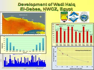
The document contains seasonal rainfall data from 1900 to 2020 presented in a line graph. It shows fluctuations in seasonal rainfall amounts over time, with some seasons receiving more rainfall than the long-term average and some receiving less. A map shows elevation levels and catchment boundaries for a Mediterranean coastal area in the range of 0 to 172 meters. Plant transplant locations are marked on the map for Atriplex, fig, peanut, pistachio and almond.

Recommandé
Recommandé
Contenu connexe
Similaire à T5: Development of Wadi Halq El-Dabaa, NWCZ, Egypt
Similaire à T5: Development of Wadi Halq El-Dabaa, NWCZ, Egypt (13)
Plus de FAO
Plus de FAO (20)
Dernier
Dernier (20)
T5: Development of Wadi Halq El-Dabaa, NWCZ, Egypt
- 1. 7 /4 0 8 4 9 /5 1 0 9 5 1 /5 1 2 9 5 3 /5 1 4 9 5 5 /5 1 6 9 5 7 /5 1 8 9 5 9 /6 1 0 9 6 1 /6 1 2 9 6 3 /6 1 4 9 6 5 /6 1 6 9 6 7 /6 1 8 9 6 9 /7 1 0 9 7 1 /7 1 2 9 7 3 /7 1 4 9 7 5 /7 1 6 9 7 6 /7 1 7 9 7 8 /7 1 9 9 8 0 /8 1 1 9 8 2 /8 1 3 9 8 4 /8 1 5 9 8 6 /8 1 7 9 8 8 /8 1 9 9 9 0 /9 1 1 9 9 2 /9 1 3 9 9 4 /9 1 5 9 9 6 /9 1 7 9 2 98 0 0 /9 9 0 /2 2 0 0 0 0 1 2 /2 2 0 0 0 0 3 4 /2 2 0 0 0 0 5 6 /2 2 0 0 0 0 7 8 /2 0 0 9 1 9 1 9 4 Rainfall (mm) 300 280 260 240 Seasonal rainfall (mm) Average seasonal rainfall 220 200 180 160 140 120 100 80 60 40 20 Season
- 2. Med it e 0 0.5 1 2 3 26°48'0"E 4 Km 26°50'0"E ea # * ( ! #! * (( ! 31°24'0"N ! 31°22'0"N 31°22'0"N 0 0.5 1 ± 31°26'0"N ! 31°20'0"N 31°20'0"N 31°22'0"N 31°20'0"N 26°46'0"E 31°18'0"N 31°24'0"N 31°24'0"N 31°22'0"N 31°20'0"N 31°18'0"N 0.01 - 25 25.01 - 50 50.01 - 75 75.01 - 100 100.01 - 125 125.01 - 150 150.01 - 172 Catchment ean S ! a ! Elevation rran 26°50'0"E 31°28'0"N 26°48'0"E 31°24'0"N ± 31°26'0"N Sea 26°46'0"E 31°28'0"N nea n 31°26'0"N 31°28'0"N Med iterr a 26°50'0"E 31°26'0"N 26°48'0"E 31°28'0"N 26°46'0"E 26°46'0"E 2 26°48'0"E 3 4 Km 26°50'0"E