Educaching
•
4 j'aime•997 vues

Educaching combines GPS technology, geocaching, and classroom subjects into outdoor learning lessons. It allows students to develop skills like critical thinking, navigation, and teamwork. Teachers can enhance any subject by having students use GPS receivers to complete tasks like measuring areas, identifying trees, or answering review questions located at marked waypoints. While start-up costs and time requirements present limitations, grants and fundraising can help obtain needed GPS units and supplies. Example lessons demonstrate how concepts in math, science, and other subjects can be taught using GPS-based scavenger hunt activities.

Recommandé
Contenu connexe
Similaire à Educaching
Similaire à Educaching (20)
Plus de Jeff Campbell
Dernier
Dernier (20)
Educaching
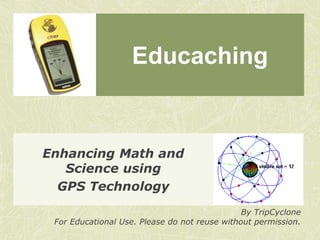
- 1. Educaching Enhancing Math and Science using GPS Technology By TripCyclone For Educational Use. Please do not reuse without permission.
- 2. What is Educaching? Educaching combines the scavenger hunt elements of Geocaching, GPS technology, and the subject matter of your class into an interactive, outdoor learning opportunity.
- 3. Value for Students Besides being another approach to learning, students can develop skills in Critical Thinking Navigation Teamwork An understanding of how to use GPS is also useful as students become drivers.
- 4. Value for Teachers Any subject matter can be taught or enhanced through Educaching. Designed to integrate within your curriculum, not replace. Can easily link lessons to State and National standards. Provides another source of active learning for students.
- 5. How does GPS work? GPS stands for Global Positioning System. The current system involves three components: Ground Component Space Component User Component
- 6. How does GPS work (cont)? Ground Component Helps ensure satellites have accurate time and orbital information. Space Component A “constellation” of 30 satellites, with several reserves, each continually sending out a signal as they orbit Earth. User Component Each receiver (GPSr) reads the signal from space. Requires signal from four satellites to determine location.
- 7. How is GPS used? Beyond Auto-Navigation, GPS is used by: Military Surveyors Scientists Park Rangers Emergency Services Airline Industry
- 8. What is Geocaching? Geocaching is an outdoor scavenger hunt using GPS. Played by millions around the world.
- 10. Incorporating Education Before developing lessons to teach your subject matter, lessons about using GPS are needed. Introduce GPS, how it works, and how to use a GPSr. Take students outside. Learn how to mark and find a waypoint. Take students outside. Learn how to use the GPSr compass and paying attention to your surroundings. Take students outside. Learn about accuracy.
- 11. Teaching your Subject Matter When developing lessons, identify three things: What concept do you want to teach? How can you apply that concept out in the world? How can that concept application be an active lesson?
- 12. Math Example Concept to teach Perimeter and Area Applying the concept Measuring the area of a parking lot Turning into active lesson Have students use GPS to mark waypoints around a parking lot. Students then use the distances between waypoints to determine perimeter and area.
- 13. Other Math Topics Indirect Measurements Conversion rates Statistics Angles Slope
- 14. Science Example Concept to teach Classification Applying the concept Identifying trees Turning into active lesson Prior to class, you mark waypoints next to different trees. Students then use GPS to navigate to one of the trees. Students use a tree identification guide to identify the type of tree they found.
- 15. Other Science Examples Astronomy Plant Growth Population Studies Geology Weather
- 16. Review Game Example Concept to teach Variable Applying the concept Reviewing previously taught material Turning into active lesson Prior to class, you hide containers that contain review questions, & create waypoints for each. Students then have to navigate to, find, and answer the questions to as many containers as possible within one class period.
- 17. Break-out Session Time to see what ideas might already be swimming in your head. Partner up with two other people, and try to develop a lesson using GPS. Remember: What concept do you want to teach? How can you apply that concept outside the classroom? How can that concept application be an active lesson?
- 18. Needed Supplies GPS Receivers (GPSr) Rechargeable batteries & charger
- 19. Optional Supplies GPS Database Software (EasyGPS) Surveyor Marking Flags Sealable containers (size varies depending on needs) Lock &Lock tupperware 2-Liter Pre-forms Ammunition Cans
- 20. Limitations of Educaching Cost Basic Garmin eTrex= $70-80 per unit Rechargeable Batteries Depends on # of GPSr’s One charger & 4 batteries set ≈ $20 Additional Batteries 4-pack ≈ $15 8-pack ≈ $25 This only covers needed materials.
- 21. Limitations cont. Time Setting up a lesson requires you to have already figured out where you want students to go. You can either enter waypoints into each GPSr on your own, or hire…ask for student volunteers. If lessons involve additional supplies, clean-up time will be needed. Don’t forget to charge batteries.
- 22. Limitations cont. Space The amount of space and type of landscape your school has can be another limiting factor. Since you are outdoors, weather is an obvious factor to consider. Schools that have developed an outdoor classroom have an advantage.
- 23. Getting $$$$ With the greatest limitation being costs, how can you get money? Grants Corporate Grant School Foundation Grant Fundraisers Online Donations DonorsChoose.org
- 24. Additional Resources http://www.educaching.com Has developed a curriculum using GPS. They sell starter kits that include GPS units. http://www.geocaching.com/ Biggest Geocaching database. Free to join and use, with additional benefits to paying users. They have an entire forum section for using GPS in Education.
- 25. Additional Resources GIS Education GIS, or Geographic Information System, is commonly used by a variety of professionals needing accurate geographic information. Can be a resource for more advanced GPS related lessons. GIS 2 GPS A resource site for Educators using GPS
- 26. Example of GIS use in Missouri
- 27. Additional Resources Earthcaching is a unique type of geocache that centers around Earth Science, without a need for hidden containers. It is sponsored by the Geological Society of America, the National Park Service, and other organizations. They have a free, 87 page Educator’s Guide online.
- 28. Outdoor Activity Time to see this in action. Outcomes Learn how to handle a GPSr Experience two Mini-Lessons
- 29. GPS Receiver Navigating the Screens Menu Compass Satellites Marking and Finding Waypoints
- 30. Activities Accuracy Lab Impacts of Accuracy on GPS Signal Working with lower accuracy Review Game Finding Containers Q & A Practice using a Receiver
- 31. Away We Go
- 32. Consider This Locations Consider where you hide a container. Containers Consider what you use for a container. Common Sense Some students will try to follow the GPSr’s arrow religiously, to the point of ignoring their surroundings.
- 33. Review Trouble Shooting Applications and Connections Q & A
Notes de l'éditeur
- Critical thinking – Upon reaching the chosen location, students learn critical thinking by determining the answer to the given problem using only the provided information.Navigation – Many students lack an understanding of even basic directions such as N-S-E-W. Using a GPSr not only helps reinforce NSEW, but also helps students learn about distances.Teamwork – Unless you have enough GPSr’s most students will work in groups, building teamwork as they work through the lesson.
- Explain difference between GPS and GPSr. GPS – Global Positioning SystemGPSr – Global Positioning System ReceiverGPS was originally designed for military use. Eventually, it was opened up for business use. It was made available for public use, but the signal accuracy was significantly degraded to the point of not being very useful due to “Selective Availability”. Selective Availability was turned off on May 1st, 2000 as part of a presidential order by President Bill Clinton. This allowed the general public to receive the signal unaltered.
- Users never directly interact with anything other than the User Component. Most users never realize that the Ground Component even exists.
- Military uses GPS for navigation, target tracking, search & rescue, reconnaissance, weapon guidance.Scientists and Park Rangers use GPS for data tracking in the field.Emergency Services use GPS for disaster relief, emergency response units, search & rescue.Airline Industry uses GPS to monitor air traffic.
- Introduce basic concept of geocaching.“Using multi-billion dollar military technology to find tupperware in the woods.”Show video.
- Geocaches located around Tan-Tar-A. Smiley faces mark geocaches previously found by Jeff.
- Depending on the class length, teachers can teach Intro to GPS lessons in 3-5 days.When we go outside, we will do a shortened version of #4.
- For #2, teachers are looking for how the concept would be actually used by people, not how to create an activity for using it. #3 is for designing the activity.
- Jerome
- JeromeConversion rates – measuring waypoints in feet and converting to meters. Also taking latitude and longitude measurements of two waypoints and converting latitude and longitude “Seconds” into feet to calculate the distance between them.Indirect Measurements – Second part of “Conversion Rates” is an example. Measuring the length of a tree’s shadow and the angle from the shadow tip to the top of the tree to determine height.Picture is of the Data Accuracy Lab, and would reflect the concept of statistics and data averaging.Slope – if GPSr elevation settings are correct, then elevation change between point A and point B, combined with the distance between said points could be used to determine slope.Angles –
- Jerome
- JeromeAstronomy – Based on location, views of certain astronomical events may vary.Plant Growth – Measure how changes in location can affect exposure to water and sunlight.Population Studies – Record locations of different plants to build a map of plant life and study the population of those plants in a given area.Geology – Mark major geologic features (faults, landslides, erosion) and plot them on a map or build a tour about them.Weather – Record locations of thermometers, rain gauges, and barometers to determine how landscape can affect those measurements.
- JeromeOne of the more involved lessons in regards to prep time, but also the one with the most flexibility and skill building.
- Garmin eTrex H (yelloweTrex) is a great classroom GPS. A bit more rugged, easy to use, and cheap. Only contains basic features and connecting to newer computers can be tough without special adaptors (doesn’t use USB).
- Ammunication cans are great when it comes to protecting their contents in case rain arrives, but they may present a problem if not properly prepared. Spray paint the can to cover up ammunition markings. Use a stencil to mark it with school identification. Do not leave outside after the lesson is over. If you think there might be a concern, discuss with your building administrator. If your building is surrounded by a neighborhood, do not put the can out until the day of the lesson and make sure it is clearly marked as a classroom tool. Lock & Lock is the best brand of “multi-latch tupperware”, but not the only brand. Hard to find in some stores, you’ll often see Rubbermaid and Sterilite versions. They are more prone to broken latches, but often cheaper.2-liter Pre-forms can be easily ordered by talking to your school’s science teacher. They are a common product in science catalogs. At first, use basic containers. As your students gain in experience, get creative.
- Many businesses are willing to offer grant opportunities. It helps their image to donate back to the community and can be reported on their business’s taxes. Wal-mart is a great example.Look into your district’s foundation or alumni association. Many offer smaller grants to teachers within their district.DonorsChoose can be tricky. It takes reaching out to get results pulled back in.
- Educaching curriculum runs for $32, plus S&H. They have a digital version for the same price, minus S&H. They also sell GPS Club guides for developing an after school program.Geocaching has a huge following, and many Geocachers are quite experienced with using GPS technology. There are often local groups who may be open to assisting you in developing lessons and learning more about GPS technology.
- Free GIS software is available at GIS Education, including specialized versions for educational use.GIS 2 GPS provides resources for lessons in both GIS and GPS, grant information, technical support, projects, classes, and additional off-site resources.
- Picture is of an Earthcache Site, designed to teach about how water carved this canyon.