
Recommandé
Contenu connexe
Plus de LEEENNA
Plus de LEEENNA (20)
Dernier
Dernier (20)
S2 GE Handout - Topo Map Reading
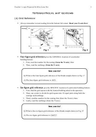
- 1. Teacher’s copy/Prepared by Miss Lena Teo 1 TOPOGRAPHICAL MAP READING (A) Grid Reference • Always remember to start reading from the bottom left corner. Read your X-axis first. • Four-figure grid reference gives the GENERAL location of a particular building/feature: 1. First, read the number for the easting (from the X-axis); then 2. Then, read the northings (from the Y-axis). • Six-figure grid reference give the SPECIFIC location of a particular building/feature: 1. First, find the grid square with the feature/building asked in the question. 2. Then, use a ruler to divide the grid square into 10 equal parts along both the eastings and northings. 3. Third, read the number for the easting first (from the X-axis); then 4. Lastly, read the northings (from the Y-axis). Now you try! Q) What is the four-figure grid reference of the Hindu temple shown in Fig. 1? A) The four-figure grid reference is 2672. Now you try! Q) What is the six-figure grid reference of the Hindu temple shown in Fig. 2? A) The six-figure grid reference is 266727.
- 2. Teacher’s copy/Prepared by Miss Lena Teo 2 (B) Compass Direction • The compass points are also called cardinal points: • To find the compass direction of one location to another location: 1. First, draw a straight line connecting the two locations/buildings. 2. Then read the question carefully – ⇒ If the question asks you the direction of A from B, then draw a ‘+’ sign at B & read the direction from B. ⇒ If the question asks you the direction of B from A, then draw a ‘+’ sign at A and read the direction from A. North EastWest South NortheastNorthwest Southwest Southeast Now you try! Q) Find the direction of Midland from Saginaw: 1. Draw the ‘+’ sign at Saginaw; 2. Then read the direction from Saginaw. A) Midland is located Northeast of Saginaw. Now you try! Q) Eg. Find the direction of Saginaw from Midland: 1. Draw the ‘+’ sign at Midland; 2. Then read the direction from Midland. A) Saginaw is located Southwest of Midland.
- 3. Teacher’s copy/Prepared by Miss Lena Teo 3 • To find the compass bearing of between two locations: 1. First, draw a straight line connecting the two locations/buildings. 2. Then read the question carefully – ⇒ If the question asks you the direction of A from B, then draw a ‘+’ sign at B & read the direction from B. (C) Straight Line Distances • Maps will always show things smaller than they are in reality. But things shown on maps are always drawn to scale. Meaning, the size of the things (ie. buildings/features/distances) on the map is always drawn using a ratio to the actual distance on the ground. • Eg. • To measure the straight line distance between two locations: 1. First, draw a straight line connecting the two locations/buildings. 2. Use a ruler to measure the distance between the two locations. Eg. You measured 2 cm on your ruler. Now you try! Q) Find the bearing of the church from the Dairy Farm: 1. Draw the ‘+’ sign at the Dairy Farm; 2. The angle you want to find starts from the 12 o’clock point. 3. Read clockwise starting from 0º . A) The compass bearing of the church from the Dairy Farm is ________. Size of church drawn on map: Size of church in reality (5 times bigger): [Scale] 1 : 5 (meaning 1 cm on the map represents 5 cm on the ground – always same units!!) [Ratio] map : reality = 1 : 5
- 4. Teacher’s copy/Prepared by Miss Lena Teo 4 3. Refer to the scale of the map to find the actual distance on the ground. Eg. The scale states 1 : 50 000 meaning, 1 cm on map represents 50 000cm/500m/0.5km on the ground. thus the 2 cm you measured on your ruler represents (2x0.5km=) 1 km on the ground. Now you try! Q) Find the straight line distance between the Chestnut Hill School and the Dairy Farm: 1. Draw a straight line connecting both locations. 2. Then use your ruler to measure the distance between them. Ruler measurement: 6.5 cm. 3. Refer to the scale on the map; take note of the unit conversion. 1 cm (map) = 25 000 cm (actual) 1 cm (map) = 250 m (actual) 1 cm (map) = 0.25 km (actual) 6.5 cm (map) = 1.625 km (actual) A) The straight line distance is 1.625 km / 1625 m. Scale 1 : 25 000
- 5. Teacher’s copy/Prepared by Miss Lena Teo 5 (D) Contour Lines • Contour lines show the height of the land. o When the contour lines are drawn close together, it means that the height of the land changes a lot over a short distance represents a steep slope. o When the contour lines are drawn far apart, it means that the height of the land changes very little over a short distance represents a gentle slope. • Contour lines have regular intervals (ie. equal increase/decrease in height between each line) Steep slopeGentle slope