Ijirt148701 paper
•
0 j'aime•32 vues

Runoff is one of the most significant hydrological variables used in most of the water resources applications. Physiographically the area is characterized by undulating topography with plains and valleys. The Soil Conservation Service Curve Numbers also known as hydrologic soil group method were used in this study. This method is adaptable and suitable approach for quick runoff estimation and is approximately easy to use with minimum data and it gives good result. From the study yearly rainfall and runoff were estimated easily. The study area covers an area of 466.02 km2, having maximum length of 36.5 km. The maximum and minimum elevation of the basin is 569 m and 341 m above MSL, respectively.

Recommandé
Recommandé
Contenu connexe
Tendances
Tendances (17)
Similaire à Ijirt148701 paper
Similaire à Ijirt148701 paper (20)
Plus de Mohammed Badiuddin Parvez
Plus de Mohammed Badiuddin Parvez (20)
Dernier
Dernier (20)
Ijirt148701 paper
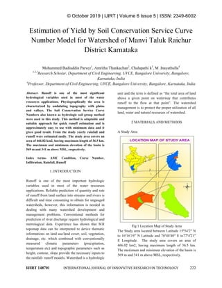
- 1. © October 2019 | IJIRT | Volume 6 Issue 5 | ISSN: 2349-6002 IJIRT 148701 INTERNATIONAL JOURNAL OF INNOVATIVE RESEARCH IN TECHNOLOGY 222 Estimation of Yield by Soil Conservation Service Curve Number Model for Watershed of Manvi Taluk Raichur District Karnataka Mohammed Badiuddin Parvez1 , Amritha Thankachan2 , Chalapathi k3 , M .Inayathulla4 1,2,3 Research Scholar, Department of Civil Engineering, UVCE, Bangalore University, Bangalore, Karnataka, India 4 Professor, Department of Civil Engineering, UVCE, Bangalore University, Bangalore, Karnataka, India Abstract- Runoff is one of the most significant hydrological variables used in most of the water resources applications. Physiographically the area is characterized by undulating topography with plains and valleys. The Soil Conservation Service Curve Numbers also known as hydrologic soil group method were used in this study. This method is adaptable and suitable approach for quick runoff estimation and is approximately easy to use with minimum data and it gives good result. From the study yearly rainfall and runoff were estimated easily. The study area covers an area of 466.02 km2, having maximum length of 36.5 km. The maximum and minimum elevation of the basin is 569 m and 341 m above MSL, respectively. Index terms- AMC Condition, Curve Number, Infiltration, Rainfall, Runoff 1. INTRODUCTION Runoff is one of the most important hydrologic variables used in most of the water resources applications. Reliable prediction of quantity and rate of runoff from land surface into streams and rivers is difficult and time consuming to obtain for ungauged watersheds, however, this information is needed in dealing with many watershed development and management problems. Conventional methods for prediction of river discharge require hydrological and metrological data. Experience has shown that SOI topomap data can be interpreted to derive thematic informations on land use/land cover, soil, vegetation, drainage, etc. which combined with conventionally measured climatic parameters (precipitation, temperature etc) and topographic parameters such as height, contour, slope provide the necessary inputs to the rainfall- runoff models. Watershed is a hydrologic unit and the term is defined as “the total area of land above a given point on waterway that contributes runoff to the flow at that point”. The watershed management is to protect the proper utilization of all land, water and natural resources of watershed. 2 MATERIALS AND METHODS A Study Area Fig 1 Location Map of Study Area The Study area located between Latitude 15º54′2′′ N to 16º16′19′′ N Latitude and 76º48′40′′ E to77º4′21′′ E Longitude. The study area covers an area of 466.02 km2, having maximum length of 36.5 km. The maximum and minimum elevation of the basin is 569 m and 341 m above MSL, respectively.
- 2. © October 2019 | IJIRT | Volume 6 Issue 5 | ISSN: 2349-6002 IJIRT 148701 INTERNATIONAL JOURNAL OF INNOVATIVE RESEARCH IN TECHNOLOGY 223 B Methodology Soil Conservation Service (SCS) Curve Number Model In this model, runoff will be determined as a function of current soil moisture content, static soil conditions, and management practices. Runoff is deduced from the water available to enter the soil prior to infiltration. Fig.2 shows the methodology adopted for runoff estimation using SCS curve number method. The SCS curve number method is developed from many years of stream flow records for agricultural watersheds in several parts of the United States. The method is also called hydrologic soil cover complex number method. It is based on the recharge capacity of a watershed. The recharge capacity can be determined by the antecedent moisture contents and by the physical characteristics of the watershed. Basically the curve number is an index that represents the combination of hydrologic soil group and antecedent moisture conditions. The SCS prepared an index, which is called as the runoff Curve Number to represent the combined hydrologic effect of soil, land use and land cover, agriculture class, hydrologic conditions and antecedent soil moisture conditions. These factors can be accessed from soil survey and the site investigations and land use maps, while using the hydrologic model for the design. The specifications of antecedent moisture conditions is often a policy decision that suggest the average watershed conditions rather than recognitions of a hydrologic conditions at a particular time and places. Expressed mathematically as given, S F IaP Q (1) Where Q is the runoff, P is the precipitation and F is the infiltrations and it is the difference between the potential and accumulated runoff. Ia is begining abstraction, which represents all the losses before the runoff begins. It include water retained in surface depressions, water intercepted by vegetation, and initial infiltrations. This is variable but generally is correlated with soil and land cover parameter; S is the potential infiltrations after the runoff begins. Thus, a runoff curve numbers is defined to relate the unknown S as a spatially distributed variable are, 25425400 CN S (2) )8.0( 2)2.0( SP SP Q (3) Fig 2: Methodology SCS Curve Number Determination of Curve Number (CN) The SCS cover complex classification consists of three factors: land use, treatment of practice and hydrologic condition. There are approximately eight different land use classes that are identified in the tables for estimating curve number. Cultivated land uses are often subdivided by treatment or practices such as contoured or straight row. This separation reflects the different hydrologic runoff potential that is associated with variation in land treatment. The hydrologic condition reflects the level of land management; it is separated with three classes as poor, fair and good. Not all of the land use classes are separated by treatment or condition. CN values for different land uses, treatment and hydrologic conditions were assigned based on the curve number table. Runoff Curve Numbers for (AMC II) hydrologic soil cover complex is shown in Table 1. Table 1 Runoff Curve Numbers for (AMC II) hydrologic soil cover complex
- 3. © October 2019 | IJIRT | Volume 6 Issue 5 | ISSN: 2349-6002 IJIRT 148701 INTERNATIONAL JOURNAL OF INNOVATIVE RESEARCH IN TECHNOLOGY 224 Hydrological Soil Group Classification SCS developed a soil classification system that consists of four groups, which are identified as A, B, C, and D according their minimum infiltration rate. The identification of the particular SCS soil group at a site can be done by one of the following three ways (i).soil characteristics (ii).county soil surveys and (iii).minimum infiltration rates. Table 2 shows the minimum infiltration rates associated with each soil group. The value of CN is shown for AMC II and for a variety of land uses, soil treatment, or farming practices. The hydrologic condition refers to the state of the vegetation growth. The Curve Number values for AMC-I and AMC-III can be obtained from AMC- II by the method of conservation. The empirical CN1 and CN3 equations for conservation methods are as follows: 2 2 1 01281.0281.2 CN CN CN (4) 2 2 3 00573.0427.0 CN CN CN (5) A weighted runoff was estimated for the watershed as )...........( )*..........**( 21 2211 n nn AAA qAqAqA WeightedQ where A1, A2…An are the areas of the watersheds having respective runoff q1, q2….qn. The weighted runoff approach was again extended to quantify the total amount of runoff from the entire watershed. 3 RESULTS AND DISCUSSIONS It is observed that during the year 2009 maximum runoff of 406.299mm. It was also observed that the minimum runoff of 32.627 mm has obtained in the year 2011. It can be seen that there is a strong positive linear dependence between the annual rainfall and runoff and it can be observed that in the regression equation as the values of slope increases the runoff generated also increases. The runoff estimation carried out by using SCS curve number method will help in proper planning and managements of catchment yield for better planning of river basins. Calculations of runoff which is balance of rainwater and the infiltration responsible for recharging the soil moisture is required for effective management of rain fed area. The inclusion of watershed characteristics such as soils, land use / land cover topography etc. in GIS software improves the accuracy and most importantly. The GIS method estimating runoff will tend to be advantageous if study area large, Runoff is modeled repetitively with alternate land use and land cover. Curve number determination using remotely sensed data has been shown to be most cost effective than conventional procedure. Fig 3: Curve Number Map Table 4: Runoff for Mini watershed Manvi
- 4. © October 2019 | IJIRT | Volume 6 Issue 5 | ISSN: 2349-6002 IJIRT 148701 INTERNATIONAL JOURNAL OF INNOVATIVE RESEARCH IN TECHNOLOGY 225 Year RainFall in mm Runoff in mm Runoff Coefficient 1998 727.500 119.887 16.479 1999 479.900 122.240 25.472 2000 620.000 123.880 19.981 2001 806.300 175.719 21.793 2002 417.600 51.967 12.444 2003 544.200 164.244 30.181 2004 595.600 126.147 21.180 2005 811.900 279.005 34.364 2006 590.400 117.300 19.868 2007 719.300 119.488 16.612 2008 567.500 88.736 15.636 2009 977.800 406.229 41.545 2010 883.500 243.934 27.610 2011 385.500 32.627 8.463 2012 537.000 106.049 19.748 2013 538.100 127.892 23.767 2014 604.100 119.370 19.760 2015 429.300 97.895 22.803 2016 565.300 78.070 13.810 Fig 4: Rainfall Runoff Correlation Fig 5: Rainfall (mm) and Runoff (mm) Bar Chart Fig 5: Percentage variation of Rainfall runoff Closure Surface runoff, the important parameter in the water balance equation, other than rainwater and infiltration (recharging factor to the soil as soil moisture) is necessary for efficient planning and management of the available water. The SCS curve number method uses, minimum data as input, and gives reliable output by using remote sensing and GIS techniques in most efficient way. The purpose of this study was to evaluate the performance of the procedure using land cover database from remotely sensed data. From the Table 4 it is observed that during the year 2009 maximum runoff of 406.299 mm has occurred. It was also observed that the minimum runoff of 32.627 mm has occurred in the year 1998. The values of correlation coefficients are very high as 0.731. Hence, it can be said that there is a strong positive linear dependence between the annual rainfall and annual runoff and it can be observed that in the regression equation as the values of slope increases the runoff generated also increases. The runoff estimation carried out by using SCS curve number method will help in proper planning and management of catchment yield for better planning of river basin. REFERENCES [1] Amutha R. and Porchelvan. P. (2009), Estimation of Surface Runoff in Malattar Sub – Watershed using SCS CN Method, Journal Indian Soc. Remote Sensing, Vol. 37, pp. 291 – 304.
- 5. © October 2019 | IJIRT | Volume 6 Issue 5 | ISSN: 2349-6002 IJIRT 148701 INTERNATIONAL JOURNAL OF INNOVATIVE RESEARCH IN TECHNOLOGY 226 [2] Clarke J. I. (1966), Morphometry from Maps, Essays in Geomorphology, Elsevier Publ. Co., New York, pp. 235- 274. [3] Mohammed Badiuddin Parvez, and M .Inayathulla. "Morphometry, Hypsometry Analysis and Runoff Estimation of Aam Talab Watershed Raichur, Karnataka" International Journal of Advance Research and Innovative Ideas In Education Volume 5 Issue 3 2019 Page 1713-1727. [4] Mohammed Badiuddin Parvez, M Inayathulla “Generation Of Intensity Duration Frequency Curves For Different Return Period Using Short Duration Rainfall For Manvi Taluk Raichur District Karnataka”, International Research Journal of Engineering and Management Studies (IRJEMS), Volume: 03 Issue: 04 | April -2019. [5] Mohammed Badiuddin Parvez, and M Inayathulla. "Generation of Short Duration Isohyetal Maps For Raichur District Karnataka" International Journal Of Advance Research And Innovative Ideas In Education Volume 5 Issue 2 2019 Page 3234-3242 BIOGRAPHY Mohammed Badiuddin Parvez Is a life member of Indian Water Resources Society, ASCE Born in Gangavathi, Obtained his BE in Civil Engineering in the year 2009-2013 from UVCE, Bangalore and M.E with specialization on Water Resources Engineering during 2013-2015 from UVCE, Bangalore University and Pursuing Ph.D from Bangalore University. And has 3 years of teaching experience. Till date, has presented and published several technical papers in many National and International seminars, Journals and conferences. Amritha Thankachan, born in Kerala, obtained her B.Tech in Civil Engineering in the year 2008-2012 from Amal Jyothi College of Engineering, Kanjirappally, Kottayam and M.Tech with specialization on Integrated Water Resources Management during 2012-2014 from Karunya University, Coimbatore. Presently pursuing Ph.D from Bangalore University. She is having more than 4 years of teaching experience. Till date, has presented and published several technical papers in many National and International Seminars and Conferences. Chalapathi k Is a life member of Indian Water Resources Society. Born in Karnataka, Obtained his BE in Civil Engineering in the year 2008- 2012 from GSKSJTI, Bangalore. and M.E with specialization on Water Resources Engineering during 2012-2014 from UVCE, Bangalore University and Pursuing Ph.D from Bangalore University. And has 3 years of teaching experience. Till date, has presented and published several technical papers in many National and International seminars and conferences. Dr M Inayathulla Is a life member of Environmental and Water Resources Engineering (EWRI), ASCE, WWI, ASTEE, ASFPM. Born in Karnataka, Obtained his BE in Civil Engineering in the year 1987-1991 from UBDT, Davanagere and M.E with specialization on Water Resources Engineering during 1992-1994 from UVCE, Bangalore University and got Doctorate from Bangalore University. Presently working as Professor at UVCE, Bangalore University, India. And has more than 25 years of teaching experience. Till date, has presented and published several technical papers in many National and International seminars and conferences.