SlideShare une entreprise Scribd logo
1  sur  2
ã2017 California Institute of Technology. Government sponsorship acknowledged.
NISAR: The NASA-ISRO SAR Mission
Crop Area Monitoring
To feed a growing population of more than 8 billion, food
production and supply occur on a global basis. In order to
better guide policy and decision making, national and
international organizations work to transparently monitor
trends and conditions of agriculture in a timely basis.
Because of the variable nature of planting and harvesting
practices, efforts such as this are manpower intensive and
time consuming tasks.
Preparing Markets for
Bountiful Harvests
NISAR will provide maps of developing crop area on a global basis every
two weeks. Observations will be uninterrupted by weather and provide
up-to-date information on the large-scale trends that affect international
food security.
Modern Remote Sensing Technology and Farming
In recent years, with the rise of silicon, modern technology has
permeated all levels of society. Through GPS, automation and
space technology, the discipline of agricultural production has
been no exception, and indeed has historically always been an
early adopter of new technology.
Food security and the accomplishments of agribusiness are
founded on the continuity of a global food supply that fluctuates
with changing national policies, regional climate variability and
market forces that govern what individual farmers and corporate
farming entities plant and harvest every year. In challenging
environments such as this, information leads to efficiency,
stability and success.
The NISAR Mission – Reliable, Consistent Observations
The NASA–ISRO Synthetic Aperture Radar (NISAR) mission, a collaboration
between the National Aeronautics and Space Administration (NASA) and the
Indian Space Research Organization (ISRO), will provide all-weather, day/night
imaging of nearly the entire land and ice masses of the Earth repeated 4-6
times per month. NISAR’s orbiting radars will image at resolutions of 5-10
meters to identify and track subtle movement of the Earth’s land and its sea
ice, and even provide information about what is happening below the surface.
NISAR will also provide information on crop area and forest biomass over time
and with enough detail to reveal changes on field scales. Products are expected
to be available 1-2 days after observation, and within hours in response to
disasters, providing actionable, timely data for many applications.
Photos (clockwise): Flickr, CC BY-NC 2.0: Kimberly Reinhart, Jason & Kris Carter, fishhawk, Eric Baker
ã2017 California Institute of Technology. Government sponsorship acknowledged.
Continued from front page
Among the organizations that track the trends in
agricultural production on a global basis is the United
Nations Food and Agriculture Organization (FAO).
According to FAO’s 2015 statistics, over eleven percent of
the Earth’s land surface (1.5 billion hectares) is used for
farming. With an increasing population, after taking into
account expected improvements in land use efficiency,
the amount of land dedicated to food production is
expected to grow 7% by 2030 to keep up with demand.
This increase is equivalent to an additional 90 million
hectares, roughly the size of Texas and Oklahoma
combined.
With the world’s population critically dependent on the
timely production of food and fresh water resources, the
need is greater now than ever before for the application
of technology to assure that population needs are met.
Among the technical tools that are used to address these
issues are the satellites that provide synoptic views of the
globe from space. Satellite sensors are routinely used to
guide decision-makers and commercial interests alike in
scheduling future plantings and monitoring the effects of
policy changes and a dynamic global marketplace.
The upcoming NISAR mission will provide dependable
observations throughout the growing season. The use of
actively generated microwave signals (L- and S-band, or
equivalently, 24 cm and 10 cm wavelength) on board the
satellite, means that the observations will be able to be
reliably planned, collected and distributed at time scales
that are commensurate with the satellite’s 12-day repeat
cycle of the full set of orbits, which images each
agricultural site at least once every 6 days. Radar images
from satellites such as NISAR are known for their ability to
penetrate through clouds and their day/night imaging
capability, which is a major limitation of optical sensors for
agriculture applications. Radar imagery will provide near-
weekly observations of almost all land areas that
complement the optical data and provide independent
information that is sensitive to the changing structure and
moisture conditions of the crops being imaged. In
addition, NISAR’s data products will be available open
access.
National Aeronautics and Space Administration For more information, visit http://nisar.jpl.nasa.gov/applications
Jet Propulsion Laboratory / California Institute of Technology / Pasadena, California / www.jpl.nasa.gov
Observations of the Earth’s land surfaces from space using radar
allows reliable and repeated measurements to be made throughout
the growing season. The structures of different crop and land cover
types provide a rich variety of responses to the radar illumination in
terms of varying polarization and frequency signatures. Because of
the rapid, time-varying nature of crop rotation, growth, and
harvest, frequently repeated radar observations can be used to
determine both the type of crop and its stage of growth.
Information like this is used to predict the health of the region’s
crops and the planned agricultural output.
Shown at right are data collected by SIR-C, a NASA mission launched
on board the space shuttle in 1994. Data from areas such as the
Dnieper River region of Ukraine were collected at study sites
distributed throughout the globe and have been used by NISAR
mission planners and other space agencies worldwide to
understand how radar data can be used to improve our knowledge
of the world around us. Modern day synthetic aperture radars
(SAR), such as the Canadian Space Agency’s Radarsat and the
European Commission’s Sentinel satellite series, have benefited
from the SIR-C mission and are being actively used today.
Two-frequency radar image of the Dnieper River growing region
collected in 1994 by NASA’s Shuttle Imaging Radar program. In
this false color image, developing wheat fields show up as bright
magenta and forests as the bright white patches that follow the
river’s border
Radar Imaging of Crops

Contenu connexe

Similaire à NISAR NASA-ISRO Synthetic Aperture Radar (NISAR) Food Security

Operational Agriculture Monitoring System Using Remote Sensing
Operational Agriculture Monitoring System Using Remote SensingOperational Agriculture Monitoring System Using Remote Sensing
Operational Agriculture Monitoring System Using Remote Sensing
Mary Adel
 
Satellite applications satellite applicationssatellite applications
Satellite applications satellite applicationssatellite applicationsSatellite applications satellite applicationssatellite applications
Satellite applications satellite applicationssatellite applications
nader babo
 
Use of remote sensing for generation of agricultural statistics
Use of remote sensing for generation of agricultural statisticsUse of remote sensing for generation of agricultural statistics
Use of remote sensing for generation of agricultural statistics
jagannatharao
 

Similaire à NISAR NASA-ISRO Synthetic Aperture Radar (NISAR) Food Security (20)

NISAR NASA-ISRO Synthetic Aperture Radar (NISAR) Volcanic Hazards
NISAR NASA-ISRO Synthetic Aperture Radar (NISAR)  Volcanic HazardsNISAR NASA-ISRO Synthetic Aperture Radar (NISAR)  Volcanic Hazards
NISAR NASA-ISRO Synthetic Aperture Radar (NISAR) Volcanic Hazards
 
Achievement of UN Sustainable Goals through GNSS Applications
Achievement of UN Sustainable Goals through GNSS ApplicationsAchievement of UN Sustainable Goals through GNSS Applications
Achievement of UN Sustainable Goals through GNSS Applications
 
NISAR NASA-ISRO Synthetic Aperture Radar (NISAR) Fire Management
NISAR NASA-ISRO Synthetic Aperture Radar (NISAR) Fire ManagementNISAR NASA-ISRO Synthetic Aperture Radar (NISAR) Fire Management
NISAR NASA-ISRO Synthetic Aperture Radar (NISAR) Fire Management
 
NISAR Oil, Gas, and Water Underground Reservoirs
NISAR Oil, Gas, and Water Underground ReservoirsNISAR Oil, Gas, and Water Underground Reservoirs
NISAR Oil, Gas, and Water Underground Reservoirs
 
Using Satellite Imagery To Better Plan, Monitor and Measure Interventions
Using Satellite Imagery To Better Plan, Monitor and Measure Interventions Using Satellite Imagery To Better Plan, Monitor and Measure Interventions
Using Satellite Imagery To Better Plan, Monitor and Measure Interventions
 
Trend_sheets_EN.pdf
Trend_sheets_EN.pdfTrend_sheets_EN.pdf
Trend_sheets_EN.pdf
 
NASA - NACD Panel 20220718 (1).pptx
NASA - NACD Panel 20220718 (1).pptxNASA - NACD Panel 20220718 (1).pptx
NASA - NACD Panel 20220718 (1).pptx
 
Application of remote sensing in precision farming
 Application of remote sensing in precision farming  Application of remote sensing in precision farming
Application of remote sensing in precision farming
 
Operational Agriculture Monitoring System Using Remote Sensing
Operational Agriculture Monitoring System Using Remote SensingOperational Agriculture Monitoring System Using Remote Sensing
Operational Agriculture Monitoring System Using Remote Sensing
 
Aerospace and remote sensing
Aerospace and remote sensingAerospace and remote sensing
Aerospace and remote sensing
 
Geospatial Tools for Targeting and Prioritisation in Agriculture
Geospatial Tools for Targeting and Prioritisation in AgricultureGeospatial Tools for Targeting and Prioritisation in Agriculture
Geospatial Tools for Targeting and Prioritisation in Agriculture
 
Soil mapping , remote sensing and use of sensors in precision farming
Soil mapping , remote sensing and use of  sensors in precision farmingSoil mapping , remote sensing and use of  sensors in precision farming
Soil mapping , remote sensing and use of sensors in precision farming
 
Satellite applications satellite applicationssatellite applications
Satellite applications satellite applicationssatellite applicationsSatellite applications satellite applicationssatellite applications
Satellite applications satellite applicationssatellite applications
 
IRJET- Classification of Agricultural Land’s Capability
IRJET-  	  Classification of Agricultural Land’s CapabilityIRJET-  	  Classification of Agricultural Land’s Capability
IRJET- Classification of Agricultural Land’s Capability
 
AGRICULTURE INFORMATION SYSTEM USING REMOTE SENSING, GEOGRAPHICAL ANALYSIS ...
AGRICULTURE INFORMATION SYSTEM USING  REMOTE SENSING, GEOGRAPHICAL  ANALYSIS ...AGRICULTURE INFORMATION SYSTEM USING  REMOTE SENSING, GEOGRAPHICAL  ANALYSIS ...
AGRICULTURE INFORMATION SYSTEM USING REMOTE SENSING, GEOGRAPHICAL ANALYSIS ...
 
Remote sensing
Remote sensingRemote sensing
Remote sensing
 
ROLE OF SATELLITE IN AGRICULTURE.pptx
ROLE OF SATELLITE IN AGRICULTURE.pptxROLE OF SATELLITE IN AGRICULTURE.pptx
ROLE OF SATELLITE IN AGRICULTURE.pptx
 
Use of remote sensing for generation of agricultural statistics
Use of remote sensing for generation of agricultural statisticsUse of remote sensing for generation of agricultural statistics
Use of remote sensing for generation of agricultural statistics
 
use in remote sensing in agriculture
use in remote sensing in agricultureuse in remote sensing in agriculture
use in remote sensing in agriculture
 
Credit seminar
Credit seminarCredit seminar
Credit seminar
 

Plus de Dr. Pankaj Dhussa

Plus de Dr. Pankaj Dhussa (20)

NASA Public Perception: Community Response to X-59 Quesst Mission: Phase 3
NASA Public Perception: Community Response to X-59 Quesst Mission: Phase 3NASA Public Perception: Community Response to X-59 Quesst Mission: Phase 3
NASA Public Perception: Community Response to X-59 Quesst Mission: Phase 3
 
NASA Overcoming the 50-Year Ban History of the Ban on Commercial Supersonic F...
NASA Overcoming the 50-Year Ban History of the Ban on Commercial Supersonic F...NASA Overcoming the 50-Year Ban History of the Ban on Commercial Supersonic F...
NASA Overcoming the 50-Year Ban History of the Ban on Commercial Supersonic F...
 
NASA Flight Demonstration and Capabilities Quesst Phase 3 Flight Operations
NASA Flight Demonstration and Capabilities Quesst Phase 3 Flight OperationsNASA Flight Demonstration and Capabilities Quesst Phase 3 Flight Operations
NASA Flight Demonstration and Capabilities Quesst Phase 3 Flight Operations
 
NASA Carbon Fiber Composites (CFC) Recycling Technology Enabled by the TuFF T...
NASA Carbon Fiber Composites (CFC) Recycling Technology Enabled by the TuFF T...NASA Carbon Fiber Composites (CFC) Recycling Technology Enabled by the TuFF T...
NASA Carbon Fiber Composites (CFC) Recycling Technology Enabled by the TuFF T...
 
NASA Urban Air Mobility Fatigue Prediction Aaron Crawford – NASA ULI Innovati...
NASA Urban Air Mobility Fatigue Prediction Aaron Crawford – NASA ULI Innovati...NASA Urban Air Mobility Fatigue Prediction Aaron Crawford – NASA ULI Innovati...
NASA Urban Air Mobility Fatigue Prediction Aaron Crawford – NASA ULI Innovati...
 
NASA Automated Repair Approaches for AAM
NASA Automated Repair Approaches for AAMNASA Automated Repair Approaches for AAM
NASA Automated Repair Approaches for AAM
 
NASA Multiscale Analysis Tool (NASMAT) Robust, Integrated, Physics-based, Non...
NASA Multiscale Analysis Tool (NASMAT) Robust, Integrated, Physics-based, Non...NASA Multiscale Analysis Tool (NASMAT) Robust, Integrated, Physics-based, Non...
NASA Multiscale Analysis Tool (NASMAT) Robust, Integrated, Physics-based, Non...
 
NASA Materials Informatics Enables Rapid Materials Discovery
NASA Materials Informatics Enables Rapid Materials DiscoveryNASA Materials Informatics Enables Rapid Materials Discovery
NASA Materials Informatics Enables Rapid Materials Discovery
 
NASA CFD Vision 2030: The Power of Exascale Computing
NASA CFD Vision 2030: The Power of Exascale ComputingNASA CFD Vision 2030: The Power of Exascale Computing
NASA CFD Vision 2030: The Power of Exascale Computing
 
NASA High Lift Common Research Model (CRM-HL) Ecosystem
NASA High Lift Common Research Model (CRM-HL) EcosystemNASA High Lift Common Research Model (CRM-HL) Ecosystem
NASA High Lift Common Research Model (CRM-HL) Ecosystem
 
NASA Aviary Open-source software tool for optimizing next-generation aircraft...
NASA Aviary Open-source software tool for optimizing next-generation aircraft...NASA Aviary Open-source software tool for optimizing next-generation aircraft...
NASA Aviary Open-source software tool for optimizing next-generation aircraft...
 
NASA Aircraft Certification by Analysis (CbA) 20-year Vision for Virtual Flig...
NASA Aircraft Certification by Analysis (CbA) 20-year Vision for Virtual Flig...NASA Aircraft Certification by Analysis (CbA) 20-year Vision for Virtual Flig...
NASA Aircraft Certification by Analysis (CbA) 20-year Vision for Virtual Flig...
 
NASA Self-Aligned Focusing Schlieren (SAFS) Flow Visualization Technique
NASA Self-Aligned Focusing Schlieren (SAFS) Flow Visualization TechniqueNASA Self-Aligned Focusing Schlieren (SAFS) Flow Visualization Technique
NASA Self-Aligned Focusing Schlieren (SAFS) Flow Visualization Technique
 
NASA DECO CAS Research into a New Operating Mode for Digitally Enabled Cooper...
NASA DECO CAS Research into a New Operating Mode for Digitally Enabled Cooper...NASA DECO CAS Research into a New Operating Mode for Digitally Enabled Cooper...
NASA DECO CAS Research into a New Operating Mode for Digitally Enabled Cooper...
 
NASA Advanced Exploration of Reliable Operation at low Altitudes: meteorology...
NASA Advanced Exploration of Reliable Operation at low Altitudes: meteorology...NASA Advanced Exploration of Reliable Operation at low Altitudes: meteorology...
NASA Advanced Exploration of Reliable Operation at low Altitudes: meteorology...
 
NASA Self-Adaptation of Loosely Coupled Systems across a System of Small Uncr...
NASA Self-Adaptation of Loosely Coupled Systems across a System of Small Uncr...NASA Self-Adaptation of Loosely Coupled Systems across a System of Small Uncr...
NASA Self-Adaptation of Loosely Coupled Systems across a System of Small Uncr...
 
NASA Safety Case Approach for Automated Flight Authorization System
NASA Safety Case Approach for Automated Flight Authorization SystemNASA Safety Case Approach for Automated Flight Authorization System
NASA Safety Case Approach for Automated Flight Authorization System
 
NASA RealWindDroneSim (RWDS) Enhancing Simulation Fidelity of small Uncrewed ...
NASA RealWindDroneSim (RWDS) Enhancing Simulation Fidelity of small Uncrewed ...NASA RealWindDroneSim (RWDS) Enhancing Simulation Fidelity of small Uncrewed ...
NASA RealWindDroneSim (RWDS) Enhancing Simulation Fidelity of small Uncrewed ...
 
NASA ARMD Test Data Portal (ATDP) Agile Development Method Introduction of an...
NASA ARMD Test Data Portal (ATDP) Agile Development Method Introduction of an...NASA ARMD Test Data Portal (ATDP) Agile Development Method Introduction of an...
NASA ARMD Test Data Portal (ATDP) Agile Development Method Introduction of an...
 
NASA ARMD Test Data Portal (ATDP) he ARMD Test Data Portal (ATDP) is a secure...
NASA ARMD Test Data Portal (ATDP) he ARMD Test Data Portal (ATDP) is a secure...NASA ARMD Test Data Portal (ATDP) he ARMD Test Data Portal (ATDP) is a secure...
NASA ARMD Test Data Portal (ATDP) he ARMD Test Data Portal (ATDP) is a secure...
 

Dernier

Why Teams call analytics are critical to your entire business
Why Teams call analytics are critical to your entire businessWhy Teams call analytics are critical to your entire business
Why Teams call analytics are critical to your entire business
panagenda
 
Cloud Frontiers: A Deep Dive into Serverless Spatial Data and FME
Cloud Frontiers:  A Deep Dive into Serverless Spatial Data and FMECloud Frontiers:  A Deep Dive into Serverless Spatial Data and FME
Cloud Frontiers: A Deep Dive into Serverless Spatial Data and FME
Safe Software
 
+971581248768>> SAFE AND ORIGINAL ABORTION PILLS FOR SALE IN DUBAI AND ABUDHA...
+971581248768>> SAFE AND ORIGINAL ABORTION PILLS FOR SALE IN DUBAI AND ABUDHA...+971581248768>> SAFE AND ORIGINAL ABORTION PILLS FOR SALE IN DUBAI AND ABUDHA...
+971581248768>> SAFE AND ORIGINAL ABORTION PILLS FOR SALE IN DUBAI AND ABUDHA...
?#DUbAI#??##{{(☎️+971_581248768%)**%*]'#abortion pills for sale in dubai@
 

Dernier (20)

Automating Google Workspace (GWS) & more with Apps Script
Automating Google Workspace (GWS) & more with Apps ScriptAutomating Google Workspace (GWS) & more with Apps Script
Automating Google Workspace (GWS) & more with Apps Script
 
Why Teams call analytics are critical to your entire business
Why Teams call analytics are critical to your entire businessWhy Teams call analytics are critical to your entire business
Why Teams call analytics are critical to your entire business
 
How to Troubleshoot Apps for the Modern Connected Worker
How to Troubleshoot Apps for the Modern Connected WorkerHow to Troubleshoot Apps for the Modern Connected Worker
How to Troubleshoot Apps for the Modern Connected Worker
 
Apidays New York 2024 - The Good, the Bad and the Governed by David O'Neill, ...
Apidays New York 2024 - The Good, the Bad and the Governed by David O'Neill, ...Apidays New York 2024 - The Good, the Bad and the Governed by David O'Neill, ...
Apidays New York 2024 - The Good, the Bad and the Governed by David O'Neill, ...
 
Connector Corner: Accelerate revenue generation using UiPath API-centric busi...
Connector Corner: Accelerate revenue generation using UiPath API-centric busi...Connector Corner: Accelerate revenue generation using UiPath API-centric busi...
Connector Corner: Accelerate revenue generation using UiPath API-centric busi...
 
FWD Group - Insurer Innovation Award 2024
FWD Group - Insurer Innovation Award 2024FWD Group - Insurer Innovation Award 2024
FWD Group - Insurer Innovation Award 2024
 
Powerful Google developer tools for immediate impact! (2023-24 C)
Powerful Google developer tools for immediate impact! (2023-24 C)Powerful Google developer tools for immediate impact! (2023-24 C)
Powerful Google developer tools for immediate impact! (2023-24 C)
 
EMPOWERMENT TECHNOLOGY GRADE 11 QUARTER 2 REVIEWER
EMPOWERMENT TECHNOLOGY GRADE 11 QUARTER 2 REVIEWEREMPOWERMENT TECHNOLOGY GRADE 11 QUARTER 2 REVIEWER
EMPOWERMENT TECHNOLOGY GRADE 11 QUARTER 2 REVIEWER
 
TrustArc Webinar - Unlock the Power of AI-Driven Data Discovery
TrustArc Webinar - Unlock the Power of AI-Driven Data DiscoveryTrustArc Webinar - Unlock the Power of AI-Driven Data Discovery
TrustArc Webinar - Unlock the Power of AI-Driven Data Discovery
 
Cloud Frontiers: A Deep Dive into Serverless Spatial Data and FME
Cloud Frontiers:  A Deep Dive into Serverless Spatial Data and FMECloud Frontiers:  A Deep Dive into Serverless Spatial Data and FME
Cloud Frontiers: A Deep Dive into Serverless Spatial Data and FME
 
Strategize a Smooth Tenant-to-tenant Migration and Copilot Takeoff
Strategize a Smooth Tenant-to-tenant Migration and Copilot TakeoffStrategize a Smooth Tenant-to-tenant Migration and Copilot Takeoff
Strategize a Smooth Tenant-to-tenant Migration and Copilot Takeoff
 
Corporate and higher education May webinar.pptx
Corporate and higher education May webinar.pptxCorporate and higher education May webinar.pptx
Corporate and higher education May webinar.pptx
 
AXA XL - Insurer Innovation Award Americas 2024
AXA XL - Insurer Innovation Award Americas 2024AXA XL - Insurer Innovation Award Americas 2024
AXA XL - Insurer Innovation Award Americas 2024
 
Mastering MySQL Database Architecture: Deep Dive into MySQL Shell and MySQL R...
Mastering MySQL Database Architecture: Deep Dive into MySQL Shell and MySQL R...Mastering MySQL Database Architecture: Deep Dive into MySQL Shell and MySQL R...
Mastering MySQL Database Architecture: Deep Dive into MySQL Shell and MySQL R...
 
TrustArc Webinar - Stay Ahead of US State Data Privacy Law Developments
TrustArc Webinar - Stay Ahead of US State Data Privacy Law DevelopmentsTrustArc Webinar - Stay Ahead of US State Data Privacy Law Developments
TrustArc Webinar - Stay Ahead of US State Data Privacy Law Developments
 
Manulife - Insurer Transformation Award 2024
Manulife - Insurer Transformation Award 2024Manulife - Insurer Transformation Award 2024
Manulife - Insurer Transformation Award 2024
 
+971581248768>> SAFE AND ORIGINAL ABORTION PILLS FOR SALE IN DUBAI AND ABUDHA...
+971581248768>> SAFE AND ORIGINAL ABORTION PILLS FOR SALE IN DUBAI AND ABUDHA...+971581248768>> SAFE AND ORIGINAL ABORTION PILLS FOR SALE IN DUBAI AND ABUDHA...
+971581248768>> SAFE AND ORIGINAL ABORTION PILLS FOR SALE IN DUBAI AND ABUDHA...
 
Apidays Singapore 2024 - Building Digital Trust in a Digital Economy by Veron...
Apidays Singapore 2024 - Building Digital Trust in a Digital Economy by Veron...Apidays Singapore 2024 - Building Digital Trust in a Digital Economy by Veron...
Apidays Singapore 2024 - Building Digital Trust in a Digital Economy by Veron...
 
Real Time Object Detection Using Open CV
Real Time Object Detection Using Open CVReal Time Object Detection Using Open CV
Real Time Object Detection Using Open CV
 
Apidays New York 2024 - The value of a flexible API Management solution for O...
Apidays New York 2024 - The value of a flexible API Management solution for O...Apidays New York 2024 - The value of a flexible API Management solution for O...
Apidays New York 2024 - The value of a flexible API Management solution for O...
 

NISAR NASA-ISRO Synthetic Aperture Radar (NISAR) Food Security

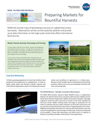
  • 1. ã2017 California Institute of Technology. Government sponsorship acknowledged. NISAR: The NASA-ISRO SAR Mission Crop Area Monitoring To feed a growing population of more than 8 billion, food production and supply occur on a global basis. In order to better guide policy and decision making, national and international organizations work to transparently monitor trends and conditions of agriculture in a timely basis. Because of the variable nature of planting and harvesting practices, efforts such as this are manpower intensive and time consuming tasks. Preparing Markets for Bountiful Harvests NISAR will provide maps of developing crop area on a global basis every two weeks. Observations will be uninterrupted by weather and provide up-to-date information on the large-scale trends that affect international food security. Modern Remote Sensing Technology and Farming In recent years, with the rise of silicon, modern technology has permeated all levels of society. Through GPS, automation and space technology, the discipline of agricultural production has been no exception, and indeed has historically always been an early adopter of new technology. Food security and the accomplishments of agribusiness are founded on the continuity of a global food supply that fluctuates with changing national policies, regional climate variability and market forces that govern what individual farmers and corporate farming entities plant and harvest every year. In challenging environments such as this, information leads to efficiency, stability and success. The NISAR Mission – Reliable, Consistent Observations The NASA–ISRO Synthetic Aperture Radar (NISAR) mission, a collaboration between the National Aeronautics and Space Administration (NASA) and the Indian Space Research Organization (ISRO), will provide all-weather, day/night imaging of nearly the entire land and ice masses of the Earth repeated 4-6 times per month. NISAR’s orbiting radars will image at resolutions of 5-10 meters to identify and track subtle movement of the Earth’s land and its sea ice, and even provide information about what is happening below the surface. NISAR will also provide information on crop area and forest biomass over time and with enough detail to reveal changes on field scales. Products are expected to be available 1-2 days after observation, and within hours in response to disasters, providing actionable, timely data for many applications. Photos (clockwise): Flickr, CC BY-NC 2.0: Kimberly Reinhart, Jason & Kris Carter, fishhawk, Eric Baker
  • 2. ã2017 California Institute of Technology. Government sponsorship acknowledged. Continued from front page Among the organizations that track the trends in agricultural production on a global basis is the United Nations Food and Agriculture Organization (FAO). According to FAO’s 2015 statistics, over eleven percent of the Earth’s land surface (1.5 billion hectares) is used for farming. With an increasing population, after taking into account expected improvements in land use efficiency, the amount of land dedicated to food production is expected to grow 7% by 2030 to keep up with demand. This increase is equivalent to an additional 90 million hectares, roughly the size of Texas and Oklahoma combined. With the world’s population critically dependent on the timely production of food and fresh water resources, the need is greater now than ever before for the application of technology to assure that population needs are met. Among the technical tools that are used to address these issues are the satellites that provide synoptic views of the globe from space. Satellite sensors are routinely used to guide decision-makers and commercial interests alike in scheduling future plantings and monitoring the effects of policy changes and a dynamic global marketplace. The upcoming NISAR mission will provide dependable observations throughout the growing season. The use of actively generated microwave signals (L- and S-band, or equivalently, 24 cm and 10 cm wavelength) on board the satellite, means that the observations will be able to be reliably planned, collected and distributed at time scales that are commensurate with the satellite’s 12-day repeat cycle of the full set of orbits, which images each agricultural site at least once every 6 days. Radar images from satellites such as NISAR are known for their ability to penetrate through clouds and their day/night imaging capability, which is a major limitation of optical sensors for agriculture applications. Radar imagery will provide near- weekly observations of almost all land areas that complement the optical data and provide independent information that is sensitive to the changing structure and moisture conditions of the crops being imaged. In addition, NISAR’s data products will be available open access. National Aeronautics and Space Administration For more information, visit http://nisar.jpl.nasa.gov/applications Jet Propulsion Laboratory / California Institute of Technology / Pasadena, California / www.jpl.nasa.gov Observations of the Earth’s land surfaces from space using radar allows reliable and repeated measurements to be made throughout the growing season. The structures of different crop and land cover types provide a rich variety of responses to the radar illumination in terms of varying polarization and frequency signatures. Because of the rapid, time-varying nature of crop rotation, growth, and harvest, frequently repeated radar observations can be used to determine both the type of crop and its stage of growth. Information like this is used to predict the health of the region’s crops and the planned agricultural output. Shown at right are data collected by SIR-C, a NASA mission launched on board the space shuttle in 1994. Data from areas such as the Dnieper River region of Ukraine were collected at study sites distributed throughout the globe and have been used by NISAR mission planners and other space agencies worldwide to understand how radar data can be used to improve our knowledge of the world around us. Modern day synthetic aperture radars (SAR), such as the Canadian Space Agency’s Radarsat and the European Commission’s Sentinel satellite series, have benefited from the SIR-C mission and are being actively used today. Two-frequency radar image of the Dnieper River growing region collected in 1994 by NASA’s Shuttle Imaging Radar program. In this false color image, developing wheat fields show up as bright magenta and forests as the bright white patches that follow the river’s border Radar Imaging of Crops