
Recommandé
Contenu connexe
Tendances
Tendances (20)
Similaire à GEOLOGICAL MAP.pptx
Similaire à GEOLOGICAL MAP.pptx (12)
Plus de cjoypingaron
Plus de cjoypingaron (20)
Dernier
Dernier (20)
GEOLOGICAL MAP.pptx
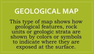
- 1. GEOLOGICAL MAP This type of map shows how geological features, rock units or geologic strata are shown by colors or symbols to indicate where they are exposed at the surface.
- 2. Symbolizing Geology •Contours and topography are just the first parts of a geologic map.The map also puts rock types, geologic structures, and more onto the printed page through colors, patterns, and symbols.
- 3. Geological Maps Features: •1. Faults •2. Tilts •3. Folds •4. Rock layers
- 4. Symbols in Geological Maps •1.Thick lines and thin lines •2. First capitalized letter in geologic unit •3. Colors •4. Dotted contact line
- 5. Parts of Geological Map: •1. Legend •2. Interpretation •3. Title •4. Susceptibility •5. Sources
- 9. TITLE
- 10. LEGEND
- 12. SUSCEPTIBILITY
- 13. SUSCEPTIBILITY
- 15. SOURCES
- 17. Direction of movement on Faults
- 18. Direction of movement on Faults
- 19. Direction of movement on Faults
- 20. Direction of movement on Faults
- 21. Direction of movement on Faults
- 22. ACTIVITY 1
- 23. Directions: Study the hazard map below, then answer the following questions. Use the landslide susceptibility legends previously discussed. •1. What are the different colors used to distinguish different areas in the map? •2. What do the colors symbolizes in the susceptibility? •3. For each hazard and level susceptibility, what actions should someone in a particular area take during periods of intense rain?