1. Flood
From Wikipedia, the free encyclopedia
Jump to: navigation, search
For other uses, see Flood (disambiguation).
Contemporary picture of the flood that struck the North Sea coast of Germany and Denmark in
October 1634.
People seeking refuge from flood in Java.ca. 1865–1876.
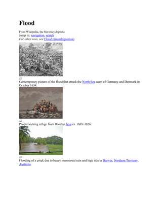
Flooding of a creek due to heavy monsoonal rain and high tide in Darwin, Northern Territory,
Australia.
2. Jeddah Flood, covering King Abdullah Street in Saudi Arabia.
Flooding near Key West, Florida, United States from Hurricane Wilma's storm surge in October
2005.
Flash flooding caused by heavy rain falling in a short amount of time.
3. Dozens of villages were inundated when rain pushed the rivers of northwestern Bangladesh over
their banks in early October 2005. The Moderate Resolution Imaging Spectroradiometer
(MODIS) on NASA’s Terra satellite captured the top image of the flooded Ghaghat and Atrai
Rivers on October 12, 2005. The deep blue of the rivers is spread across the countryside in the
flood image.
A flood is an overflow of water that submerges land.[1] The European Union (EU) Floods
Directivedefines a flood as a covering by water of land not normally covered by water.[2] In the
sense of "flowing water", the word may also be applied to the inflow of the tide. Flooding may
result from the volume of water within a body of water, such as a river or lake, which overflows
or breaks levees, with the result that some of the water escapes its usual boundaries,[3] or may be
due to accumulation of rainwater on saturated ground in an areal flood.
While the size of a lake or other body of water will vary with seasonal changes in precipitation
and snow melt, it is not a significant flood unless such escapes of water endanger land areas used
by man like a village, city or other inhabited area.
Floods can also occur in rivers, when flow exceeds the capacity of the river channel, particularly
at bends or meanders. Floods often cause damage to homes and businesses if they are placed in
natural flood plains of rivers. While flood damage can be virtually eliminated by moving away
from rivers and other bodies of water, since time out of mind, people have lived and worked by
the water to seek sustenance and capitalize on the gains of cheap and easy travel and commerce
by being near water. That humans continue to inhabit areas threatened by flood damage is
evidence that the perceived value of living near the water exceeds the cost of repeated periodic
flooding.
The word "flood" comes from the Old Englishflod, a word common to Germanic languages
(compare German Flut, Dutch vloed from the same root as is seen in flow, float; also compare
with Latin fluctus, flumen). Deluge myths are mythical stories of a great flood sent by a deity or
4. deities to destroy civilization as an act of divine retribution, and are featured in the mythology of
many cultures.
Contents
[hide]
1 Principal types and causes
o 1.1 Areal
o 1.2 Riverine
o 1.3 Estuarine
o 1.4 Coastal
o 1.5 Catastrophic
o 1.6 Human-induced
2 Effects
o 2.1 Primary effects
o 2.2 Secondary effects
o 2.3 Tertiary and long-term effects
3 Control
o 3.1 Europe
o 3.2 North America
o 3.3 Asia
o 3.4 Africa
o 3.5 Clean-up safety
4 Benefits
5 Computer modelling
6 Deadliest floods
7 See also
8 References
9 Bibliography
10 External links
[edit] Principal types and causes
[edit] Areal
Floods often happen over flat or low-lying areas when the ground is saturated and water
either cannot run off, or cannot run off quickly enough to stop accumulating. This may be
later followed by a river flood as water moves away from the areal floodplain into local
rivers and streams.
Floods can occur if water accumulates across an impermeable surface (e.g. from rainfall)
and cannot rapidly dissipate (i.e. gentle orientation or low evaporation).
A series of storms moving over the same area can cause areal flash flooding.
5. A muddy flood is produced by an accumulation of runoff generated on cropland.
Sediments are then detached by runoff and carried as suspended matter or bed load.
Muddy runoff is more likely detected when it reaches inhabited areas. Muddy floods are
therefore a hill slope process, and confusion with mudflows produced by mass
movements should be avoided.
[edit] Riverine
Slow kinds: Runoff from sustained rainfall or rapid snow melt exceeding the capacity of
a river's channel. Causes include heavy rains from monsoons, hurricanes and tropical
depressions, foreign winds and warm rain affecting snow pack. Unexpected drainage
obstructions such as landslides, ice, or debris can cause slow flooding upstream of the
obstruction.
Fast kinds: include river flash floods resulting from convective precipitation (intense
thunderstorms) or sudden release from an upstream impoundment created behind a dam,
landslide, or glacier.
Dam-building beavers can flood low-lying urban and rural areas, often causing
significant damage.
[edit] Estuarine
Commonly caused by a combination of sea tidal surges caused by storm-force winds and
high river stages due to heavy rain.
[edit] Coastal
Caused by severe sea storms, or as a result of another hazard (e.g. tsunami or hurricane).
A storm surge, from either a tropical cyclone or an extratropical cyclone, falls within this
category.
[edit] Catastrophic
Caused by a significant and unexpected event e.g. dam breakage, or as a result of another
hazard (e.g. earthquake or volcanic eruption). See outburst flood.
[edit] Human-induced
Accidental damage by workmen to tunnels or pipes.
[edit] Effects
[edit] Primary effects
Physical damage – damage to structures, including bridges, buildings, sewerage systems,
roadways, and canals.
6. [edit] Secondary effects
Water supplies – Contamination of water. Clean drinking water will become scarce.
Diseases – Unhygienic conditions. Spread of water-borne diseases.
Crops and food supplies – Shortage of food crops can be caused due to loss of entire
harvest.[4] However, lowlands near rivers depend upon river silt deposited by floods in
order to add nutrients to the local soil.
Trees – Non-tolerant species can die from suffocation.[5]
Transport – Transport links destroyed, so hard to get emergency aid to those who need it.
[edit] Tertiary and long-term effects
Economic – economic hardship due to temporary decline in tourism, rebuilding costs,
food shortage leading to price increase, etc.
Psychological – flooding can be highly traumatic for individuals, in particular where
deaths, serious injuries and loss of property occurs.
[edit] Control
Main article: Flood control
Autumn Mediterranean flooding in Alicante (Spain), 1997.
7. The River Berounka, Czech Republic, burst its banks in the 2002 European floods and houses in
the village of HlásnáTřebaň, Beroun District, were inundated.
Debris and bank erosion left after the 2009 Red River Flood in Winnipeg, Manitoba.
Pittsburgh floods in 1936
Flooding near Snoqualmie, Washington, 2009.
Floods in Bangladesh 2009
8. In many countries across the world, rivers prone to floods are often carefully managed. Defenses
such as levees,[6]bunds, reservoirs, and weirs are used to prevent rivers from bursting their banks.
When these defenses fail, emergency measures such as sandbags or portable inflatable tubes are
used. Coastal flooding has been addressed in Europe and the Americas with coastal defences,
such as sea walls, beach nourishment, and barrier islands.
[edit] Europe
Remembering the misery and destruction caused by the 1910 Great Flood of Paris, the French
government built a series of reservoirs called Les GrandsLacs de Seine (or Great Lakes) which
helps remove pressure from the Seine during floods, especially the regular winter flooding.[7]
London is protected from sea flooding by the Thames Barrier, a huge mechanical barrier across
the River Thames, which is raised when the sea water level reaches a certain point.
Venice has a similar arrangement, although it is already unable to cope with very high tides; a
new system of variable-height dikes is under construction. The defences of both London and
Venice would be rendered inadequate if sea levels were to rise.
The Adige in Northern Italy was provided with an underground canal that allows to drain part of
its flow into the Garda Lake (in the Po drainage basin), thus lessening the risk of estuarine
floods. The underground canal has been used twice, in 1966 and 2000.
The largest and most elaborate flood defences can be found in the Netherlands, where they are
referred to as Delta Works with the Oosterschelde dam as its crowning achievement. These
works were built in response to the North Sea flood of 1953 of the southwestern part of the
Netherlands. The Dutch had already built one of the world's largest dams in the north of the
country: the Afsluitdijk (closing occurred in 1932).
Currently the Saint Petersburg Flood Prevention Facility Complex is to be finished by 2008, in
Russia, to protect Saint Petersburg from storm surges. It also has a main traffic function, as it
completes a ring road around Saint Petersburg. Eleven dams extend for 25.4 kilometres and stand
eight metres above water level.
In Austria, flooding for over 150 years, has been controlled by various actions of the Vienna
Danube regulation, with dredging of the main Danube during 1870–75, and creation of the New
Danube from 1972–1988.
In Northern Ireland flood risk management is provided by Rivers Agency.
[edit] North America
Another elaborate system of floodway defences can be found in the Canadian province of
Manitoba. The Red River flows northward from the United States, passing through the city of
Winnipeg (where it meets the Assiniboine River) and into Lake Winnipeg. As is the case with all
north-flowing rivers in the temperate zone of the Northern Hemisphere, snowmelt in southern
9. sections may cause river levels to rise before northern sections have had a chance to completely
thaw. This can lead to devastating flooding, as occurred in Winnipeg during the spring of 1950.
To protect the city from future floods, the Manitoba government undertook the construction of a
massive system of diversions, dikes, and floodways (including the Red River Floodway and the
Portage Diversion). The system kept Winnipeg safe during the 1997 flood that devastated many
communities upriver from Winnipeg, including Grand Forks, North Dakota and Ste. Agathe,
Manitoba. It also kept Winnipeg safe during the 2009 flood.
In the U.S., the New Orleans Metropolitan Area, 35% of which sits below sea level, is protected
by hundreds of miles of levees and flood gates. This system failed catastrophically, in numerous
sections, during Hurricane Katrina, in the city proper and in eastern sections of the Metro Area,
resulting in the inundation of approximately 50% of the metropolitan area, ranging from a few
centimetres to 8.2 metres (a few inches to 27 feet) in coastal communities.[8] In an act of
successful flood prevention, the Federal Government of the United States offered to buy out
flood-prone properties in the United States in order to prevent repeated disasters after the 1993
flood across the Midwest. Several communities accepted and the government, in partnership with
the state, bought 25,000 properties which they converted into wetlands. These wetlands act as a
sponge in storms and in 1995, when the floods returned, the government did not have to expend
resources in those areas.[9]
[edit] Asia
In India, Bangladesh and China, flood diversion areas are rural areas that are deliberately flooded
in emergencies in order to protect cities.[10]
Many have proposed that loss of vegetation (deforestation) will lead to a risk increase. With
natural forest cover the flood duration should decrease. Reducing the rate of deforestation should
improve the incidents and severity of floods.[11]
[edit] Africa
In Egypt, both the Aswan Dam (1902) and the Aswan High Dam (1976) have controlled various
amounts of flooding along the Nile river.
[edit] Clean-up safety
Clean-up activities following floods often pose hazards to workers and volunteers involved in the
effort. Potential dangers include: water polluted by mixing with and causing overflows from
sanitary sewers, electrical hazards, carbon monoxide exposure, musculoskeletal hazards, heat or
cold stress, motor vehicle-related dangers, fire, drowning, and exposure to hazardous
materials.[12] Because flooded disaster sites are unstable, clean-up workers might encounter sharp
jagged debris, biological hazards in the flood water, exposed electrical lines, blood or other body
fluids, and animal and human remains. In planning for and reacting to flood disasters, managers
provide workers with hard hats, goggles, heavy work gloves, life jackets, and watertight boots
with steel toes and insoles.[13]
10. [edit] Benefits
There are many disruptive effects of flooding on human settlements and economic activities.
However, floods (in particular the more frequent/smaller floods) can also bring many benefits,
such as recharging ground water, making soil more fertile and providing nutrients in which it is
deficient. Flood waters provide much needed water resources in particular in arid and semi-arid
regions where precipitation events can be very unevenly distributed throughout the year.
Freshwater floods, particularly play an important role in maintaining ecosystems in river
corridors and are a key factor in maintaining floodplain biodiversity.[14] Flooding adds a lot of
nutrients to lakes and rivers which leads to improved fisheries for a few years, also because of
the suitability of a floodplain for spawning (little predation and a lot of nutrients).[15] Fish like the
weather fish make use of floods to reach new habitats. Together with fish also birds profit from
the boost in production caused by flooding.[16]
Periodic flooding was essential to the well-being of ancient communities along the Tigris-
Euphrates Rivers, the Nile River, the Indus River, the Ganges and the Yellow River, among
others. The viability for hydrological based renewable sources of energy is higher in flood prone
regions.
[edit] Computer modelling
While flood modelling is a fairly recent practice, attempts to understand and manage the
mechanisms at work in floodplains have been made for at least six millennia.[17] The recent
development in computational flood modelling has enabled engineers to step away from the tried
and tested "hold or break" approach and its tendency to promote overly engineered structures.
Various computational flood models have been developed in recent years; either 1D models
(flood levels measured in the channel) and 2D models (variable flood depth measured across the
extent of the floodplain). HEC-RAS,[18] the Hydraulic Engineering Centre model, is currently
among the most popular if only because it is available free of charge. Other models such as
TUFLOW[19] combine 1D and 2D components to derive flood depth across the river channel and
floodplain. To date the focus has primarily been on mapping tidal and fluvial flood events, but
the 2007 flood events in the UK have shifted the emphasis there onto the impact of surface water
flooding.
[20]
[edit] Deadliest floods
Main article: List of deadliest floods
Below is a list of the deadliest floods worldwide, showing events with death tolls at or above
100,000 individuals.
11. Death toll Event Location Date
2,500,000–
1931 China floods China 1931
3,700,000[21]
900,000– 1887 Yellow River (Huang He)
China 1887
2,000,000 flood
1938 Yellow River (Huang He)
500,000–700,000 China 1938
flood
Banqiao Dam failure, result of
Typhoon Nina. Approximately
231,000 86,000 people died from flooding China 1975
and another 145,000 died during
subsequent disease.
230,000 Indian Ocean tsunami Indonesia 2004
145,000 1935 Yangtze river flood China 1935
100,000+ St. Felix's Flood, storm surge Netherlands 1530
100,000 Hanoi and Red River Delta flood North Vietnam 1971
100,000 1911 Yangtze river flood China 1911
[edit] See also
Environment portal
Ecology portal
Chicago Flood, man-made flood under downtown Chicago
Disaster preparedness
Flood control in the Netherlands
Flood pulse concept
Flood Risk Assessment
Floods directive
Floods in Australia
Floods in the Netherlands
Floods in the United States
List of floods
SMS (hydrology software)
Storm tides of the North Sea
[edit] References
1. ^ MSN Encarta Dictionary. Flood. Retrieved on 2006-12-28. Archived 2009-10-31.
2. ^Directive 2007/60/EC Chapter 1 Article2. eur-lex.europa.eu. Retrieved on 2012-06-12.
3. ^ Glossary of Meteorology (June 2000). Flood. Retrieved on 2009-01-09.
4. ^http://www.southasianfloods.org
12. 5. ^ Stephen Bratkovich, Lisa Burban, et al., "Flooding and its Effects on Trees", USDA Forest Service,
Northeastern Area State and Private Forestry, St. Paul, MN, September 1993, webpage: Na.fs.fed.us-flood-
cover.
6. ^ Henry Petroski (2006). Levees and Other Raised Ground. 94. American Scientist. pp. 7–11.
7. ^ See Jeffrey H. Jackson, Paris Under Water: How the City of Light Survived the Great Flood of 1910
(New York: Palgrave Macmillan, 2010).
8. ^United States Department of Commerce (June 2006). "Hurricane Katrina Service Assessment Report"
(PDF). http://www.weather.gov/om/assessments/pdfs/Katrina.pdf. Retrieved 2006-07-14.
9. ^ Amanda Ripley. "Floods, Tornadoes, Hurricanes, Wildfires, Earthquakes... Why We Don't
Prepare."Time. August 28, 2006.
10. ^"China blows up seventh dike to divert flooding."China Daily. 2003-07-07.
11. ^ Bradshaw CJ, Sodhi NS, Peh SH, Brook BW. (2007). Global evidence that deforestation amplifies flood
risk and severity in the developing. Also a flood has recently hit Pakistan which is said to be more
devastating then the Tsunami of 2005 world. Global Change Biology, 13: 2379–2395.
12. ^ United States National Institute for Occupational Safety and Health (NIOSH). Storm and Flood Cleanup.
Accessed 23 September 2008.
13. ^ NIOSH. NIOSH Warns of Hazards of Flood Cleanup Work. NIOSH Publication No. 94-123.
14. ^ WMO/GWP Associated Programme on Flood Management "Environmental Aspects of Integrated Flood
Management." WMO, 2007
15. ^Extension of the Flood Pulse Concept. Kops.ub.uni-konstanz.de. Retrieved on 2012-06-12.
16. ^Birdlife soars above Botswana's floodplains. Africa.ipsterraviva.net (2010-10-15). Retrieved on 2012-06-
12.
17. ^Dyhouse, G. "Flood modelling Using HEC-RAS (First Edition)." Haestad Press, Waterbury (USA), 2003.
18. ^ United States Army Corps of Engineers. Davis, CA. Hydrologic Engineering Center.
19. ^ BMT WBM Pty Ltd., Brisbane, Queensland. "TUFLOW Flood and Tide Simulation Software."
20. ^ Cabinet Office, UK. "Pitt Review: Lessons learned from the 2007 floods." June 2008.
21. ^Worst Natural Disasters In History. Nbc10.com (2012-06-07). Retrieved on 2012-06-12.
[edit] Bibliography
O'Connor, Jim E. and John E. Costa. (2004). The World's Largest Floods, Past and
Present: Their Causes and Magnitudes [Circular 1254]. Washington, D.C.: U.S.
Department of the Interior, U.S. Geological Survey.
Thompson, M.T. (1964). Historical Floods in New England [Geological Survey Water-
Supply Paper 1779-M]. Washington, D.C.: United States Government Printing Office.
Powell, W. Gabe. 2009. Identifying Land Use/Land Cover (LULC) Using National
Agriculture Imagery Program (NAIP) Data as a Hydrologic Model Input for Local Flood
Plain Management. Applied Research Project. Texas State University – San Marcos.
[edit] External links
Wikimedia Commons has media related to: Flood
Wikinews has related news: Flood
This article's use of external links may not follow Wikipedia's policies or guidelines.
Please improve this article by removing excessive or inappropriate external links, and
converting useful links where appropriate into footnote references. (January 2011)
13. Website on the Great Flood of Paris in 1910
U.S. Centers for Disease Control and Prevention (CDC) Healthy Water – Flood Water
Exposure Health risks, cleanup of flood waters, and links to flood resources
American Water Resources Association
Associated Programme on Flood Management from World Meteorological Organization
Dartmouth Flood Observatory
Decision tree to choose an uncertainty method for hydrological and hydraulic modelling,
Choosing an uncertainty analysis for flood modeling.
DeltaWorks.Org Flood protecting dams and barriers project in the Netherlands
Video: Monsoon flooding, in Phnom Penh, Cambodia
Europe floods 2006
Flood Risk Management Research Consortium
International Flood Initiative
International teaching module "Integrated Flood Risk Management of Extreme Events"
(Floodmaster)
Predictions Off for Global Warming Flood Risk – Study.
Protecting against the Next Katrina – Scientific American Magazine (October 2005)
Related articles at Appropedia, a wiki for non-Wikipedia (projects & practical "how to")
content.
Safecoast Knowledge exchange on coastal flooding and climate change in the North Sea
region
Social & Economic Benefits/Costs of Heavy Rain & Flooding NOAA Economics
Riversagencyni.gov.uk, Rivers Agency of Northern Ireland
UN-CECAR research and courses on flood disaster risk management and climate change
adaptation