Area Appreciation - Gagan Vihar
•Télécharger en tant que PPTX, PDF•
8 j'aime•5,913 vues

Gagan Vihar falls in zone E and sub zone E-10 in eastern Delhi. It was developed in 1972 as a plotted residential colony. The area is well connected to nearby areas via arterial roads and public transportation like the Preet Vihar metro station. Land use is primarily residential, comprising of plotted housing ranging from single to four stories. In recent years, there has been an increase in built-up area and building heights as plots redevelop to the maximum permissible FAR under the master plans. Basic physical and social infrastructure is available but requires improvements to fully meet growing demands.

Recommandé
Contenu connexe
Tendances
Tendances (20)
Similaire à Area Appreciation - Gagan Vihar
Similaire à Area Appreciation - Gagan Vihar (20)
Plus de Dhanya Pravin
Plus de Dhanya Pravin (19)
Dernier
Dernier (20)
Area Appreciation - Gagan Vihar
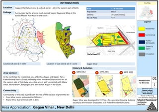
- 1. Key Map Legend 01Introduction to the area Chandani Lohani Dhanya Poduval Karman Kaur Sethi Rovin Kashyap Master of Planning First Semester Integrated School of Planning and Architecture, New Delhi Area Appreciation: Gagan Vihar , New Delhi INTRODUCTION Gagan Vihar falls in zone E and sub zone E -10 in the eastern part of Delhi. Surrounded by the arterial roads named Swami Dayanand Marg in the east & Master Plan Road in the south. In the north lies the residential area of Krishna Nagar and Baldev Park ; Karkardooma District Court and many other renowned institutions lies on the eastern side of the study area. Also area is well connected with Mayur Vihar, Akshardham , Patparganj and New Ashok Nagar in the south. Location of zone E in Delhi Location of sub-zone E-10 in E zone Gagan Vihar Karkardooma Preet Vihar Jagatpuri Connectivity of the area is good with the rest of the city due to proximity to:- • Preet Vihar metro station within 500mtrs. • Anand Vihar bus terminal with in 2km. Location Linkage Area Context Connectivity History & Evolution Gagan Vihar was developed in 1972 as a Co- operative Housing Building society by the Aviation Employees as a Plotted Residential Colony Residential Commercial Public/ Semipublic Circulation Green & Open MPD 1962 MPD 2001 MPD 2021 Area 17.5 hectares Population 6682 Density 381pph (Gross) No. of Plots 414 100m 200m
- 2. Gagan Vihar Sahibabad Vaishali Laxmi Nagar Mayur Vihar Jhilmil Colony Ideal&Institute&Of&Management&And& Technology&And&School&Of&Law Anand Vihar ISBT Shanti&Mukund Hospital V3S&Mall Mayur Public&School Madhu vihar Market Cross&River&Mall Aggarwal&Funcity Mall Kendra& vidhyalya NFC& Vigyan Vihar Geeta Colony& Market Childrens Hospital Acharya&Niketan Market 2KM:(Radius) 5KM:(Radius) Patparganj Industrial&Area Key Map Legend 02CONNECTIVITY & LINKAGES Chandani Lohani Dhanya Poduval Karman Kaur Sethi Rovin Kashyap Master of Planning First Semester Integrated School of Planning and Architecture, New Delhi Area Appreciation: Gagan Vihar , New Delhi 25 KM 11 KM IGI International Airport 25km Nizammudin Railway Station New Delhi Railway Station 9km 11km ISBT Interstate Bus terminal 6 km National Highways NH 1 , NH 10 , NH 8 , NH 2 , NH24 Rajeev Chowk 8 km Functional Connectivity Shanti Hospital Site Connectivity Preet Vihar Metro Station karkarduma Metro Station Gagan Vihar Bus stop Preet Vihar Bus stop Mausam Vihar Bus stop Mayur School Preet Vihar Metro Station Cross River Mall Kendriya Vidyalya Anand Vihar ISBT Preet Vihar Karkarduma 9 44 79 19 10 CONNECTIVITY NH 10 to Rohtak NH 8 to Gurgaon NH 2 to Faridabad NH 24 to Ghaziabad NH 1 to Karnal 09 KM 6 KM 09 KM
- 3. Key Map Legend 03 Landuse Chandani Lohani Dhanya Poduval Karman Kaur Sethi Rovin Kashyap Master of Planning First Semester Integrated School of Planning and Architecture, New Delhi Area Appreciation: Gagan Vihar , New Delhi LAND USE EXISTING LAND USE MAP EXISTING LAND USE DISTRBUTION 2017 60% 2% 5% 10% 12% 11% LANDUSE % Residential 55% Commercial 1% Public/Semi Public 3% Green & Open 12% Mixed 12% Circulation 17% Total 100% PROPOSED LAND USE DISTRBUTION AS PER LAYOUT PLAN 1972 47% 2% 18% 10% 12% 11% LANDUSE % Residential 45% Commercial 2% Public/Semi Public 16% Green & Open 10% Mixed 11% Circulation 17% Total 100% PROPOSED LAND USE MAP Initially in 1972 when the layout plan was made for Gagan Vihar, a 8.2 acre plot was reserved for a school – which later developed as GAGAN VIHAR EXTENSION Residential Commercial Public/ Semipublic Mixed Circulation Green & Open 50m 100m Preet Vihar Jitar Nagar Mausam Vihar
- 4. Key Map Legend 04Built &Open Chandani Lohani Dhanya Poduval Karman Kaur Sethi Rovin Kashyap Master of Planning First Semester Integrated School of Planning and Architecture, New Delhi Area Appreciation: Gagan Vihar , New Delhi BUILT & OPEN SPACES • In 1972 when the layout of the area was developed – an 8.2 acre parcel of land was reserved for a school in the area. Hence , the land was vacant for a very long time. • Later the area was developed as GAGAN VIHAR EXTENSION as an un authorized colony. • Around 28% of the area is covered by built mass (ground coverage only ) • These comprises of plotted housing ranging from single storey (G) to four storey (G+4) Observations Evolution of Built – Open area over time 78% 22% Map : Built and Open Spaces - 1993 Chart: Built and Open Spaces (1972) 59% 41% Chart: Built and Open Spaces (2017) 50m 100m Inference The built mass have increased as Gagan Vihar Extension have came up in the earlier vacant land
- 5. Key Map Legend 05Building height Chandani Lohani Dhanya Poduval Karman Kaur Sethi Rovin Kashyap Master of Planning First Semester Integrated School of Planning and Architecture, New Delhi Area Appreciation: Gagan Vihar , New Delhi BUILDING HEIGHTS DISTRIBUTION OF HEIGHTS Aerial view of the area from Master Plan Road EXISTING BUILDING HEIGHTS MAP Aerial view from Bhisham Lal Sharma Marg G G+1 G+2 G+3 New G+3 constructions Old G+1 constructions 0.5km 1km Under construction units HEIGHTS DU PERCENTAGE G + 3 267 65% G + 2 22 5% G + 1 74 18% G 51 12% HEIGHTS 414 100% 65%5% 18% 12% Inference • The tend of moving vertically higher hints at the demand of space resources to provide for quality of population. • As per MPD 1962, majority plots were G+1. • According to MPD 2021 norms, the permissible heights of all plots have been increased to G+3 storeys. • Old ' ground and ground+1' storeyed construction is being renovated and transformed into G+3. • According to MPD 2021 norms, the ground coverage of all plots have been increased thereby increasing the total built up area.
- 6. Key Map Legend 06 Real Estate Chandani Lohani Dhanya Poduval Karman Kaur Sethi Rovin Kashyap Master of Planning First Semester Integrated School of Planning and Architecture, New Delhi Area Appreciation: Gagan Vihar , New Delhi Real Estate 100-200 sq. yd. 200-300 sq. yd. 300-400 sq. yd. Distribution of Plot Sizes in Gagan Vihar Map : Variation of Plot Sizes Area No. of Plots % 100-200 sq. yards 80 20.4% 200-300 sq. yards 64 14.4% 300 – 400 sq. yards 270 65.2% TOTAL 414 100% 20.4% 14.4% 65.2% 100-200 sq yd 200 - 300 sq yd 300 400 sq yd • Out of TOTAL 414 PLOTS – 405 are residential • Remaining plots are commercial & public / semipublic in nature • Plot size ranges between 100 sq. yd. to 400 sq. yd. Observations Real estate prices in Gagan Vihar varies between Main Gagan Vihar and Gagan Vihar Extension. Ownership Basis In Gagan Vihar Main – Average price per sq. yd. is 2 Lakh rupees . A plot costs between 2 crore approximately for 100-200 sq. yd. and upto 8 crores for 300 – 400 sq. yd. Rental Basis In Gagan Vihar Main – Average rental price per sq. yd. is 20 rupees . Chart: variation of Plot Sizes Table: variation of Plot Sizes 50m 100m Inference Price of real estate varies in Gagan Vihar and Gagan Vihar extension
- 7. Key Map Legend 07Social Infrastructure Chandani Lohani Dhanya Poduval Karman Kaur Sethi Rovin Kashyap Master of Planning First Semester Integrated School of Planning and Architecture, New Delhi Area Appreciation: Gagan Vihar , New Delhi SOCIAL INFRASTRUCTURE Health Facilities MPD 2021 norms Area Facility No. 1. Housing Area Population 5000 - 2 . Neighborhood Population 10000 Dispensary 1 Existing 1. Stone specialist clinic 2. Multi specialty hospital 3. Dispensary 4. Private clinics Recreation Facilities MPD 2021 norms Existing Area Facility No. 1. Housing Area Population 5000 • Tot – Lot • Housing Area Park • Housing Area Playground 20 1 1 Facility No. • Housing Area Park 5 • Community Club Park 1 Religious Buildings MPD 2021 norms Existing Area Facility No. 1. Housing Area Population 5000 Religious Building - 2 . Neighborhood Population 10000 Religious Building 2 Facility No. • Religious Building 2 Education Facilities MPD 2021 norms Existing Area Facility No. 1. Housing Area Population 5000 - - 2 . Neighborhood Population 10000 Nursery Primary Sr. Sec. 2 1 1 Facility No. • Nursery 2 • Primary 0 • Sr. Sec. 0 Health Recreation Religious B. Education Nursery School Park Temple Dispensary Existing Social Infrastructure Facilities
- 8. Key Map Legend 08Physical Infrastructure Chandani Lohani Dhanya Poduval Karman Kaur Sethi Rovin Kashyap Master of Planning First Semester Integrated School of Planning and Architecture, New Delhi Area Appreciation: Gagan Vihar , New Delhi PHYSICAL INFRASTRUCTURE WATER SUPPLY Water Supply in Gagan Vihar is managed by Delhi Jal Board (DJB) MPD 2021 norms Existing As per MPD 2021, water supply of 150 LPCD + 15% wastage is required Gagan Vihar is getting approximately 158 LPCD which is adequate Timings Timings of Water Supply are 0430hrs to 0630hrs in the morning and 1630hrs to 1830hrs in the evening. Source Water is supplied through water pipes in the area which is supported by Preet Vihar water booster pumping station. POWER SUPPLY • Delhi is divided into 3 regions for Power Supply which is further divided into regions and sub regions. • Power Supply is managed by BSES Yamuna Power limited in Gagan Vihar by 2 Transformers existing in the area. • Power distribution inside the area is done by over head cables. SEWERAGE & DRAINAGE Sewerage Network has been laid parallel to water supply network. Each plot is connected to 250mm dia sewer pipelines in further connects to 450mm dia lines running along Master Plan Road. The sewerage then reaches Yamuna Vihar sewerage treatment plant. The drains collect the water and lead to Nallah which further meets Ghazipur drain and then meets the Yamuna River The Sewerage and Drainage systems are maintained by MCD Lines Nalah Gazipur Drains Yamuna River SOLID WASTE MANAGEMENT Door to Door Collection of waste is done once in a day and the waste is then dumped in the dhalao The waste is then picked up by MCD trucks and transported to dumping sites in outskirts of Delhi. ESS ESS T T Electricity sub station Transformer Overhead Tank Dhalao Map : Physical infrastructure Transformer in the area Dhalao in the area Legend • No provision for drinking water in public areas. • Insufficient Public toilets. Lack of organized electric system. • No provision for segregation of garbage 50m 100m
- 9. Key Map Legend 09 Environment Chandani Lohani Dhanya Poduval Karman Kaur Sethi Rovin Kashyap Master of Planning First Semester Integrated School of Planning and Architecture, New Delhi Area Appreciation: Gagan Vihar , New Delhi ENVIRONMENT Parks & Open Spaces Well maintained recreational center and parks are provided. Planting Design in the study area • Boundary plantation It is done to form a buffer between two areas • Predominant type of trees Evergreen tree Neem Tree and Ashoka tree • Reason for Boundary Plantation: To act as a physical barrier and visual edge. To channelize & modulate the wind direction & speed. 10 90 Green & Open spaces Rest • Breeding ground for insects and mosquitoes, causing diseases. Percentage of Green & Open Effects of Gazipur Drain • The area around the drain act as ill used open space and a ground for informal settlements in the area • The drain leads to strong Pungent Smell around the area. Boundary Plantation Gazipur DrainTree along boundary Plantation along boundary Parks Plantation
- 10. INFORMAL SECTOR Key Map Legend 10INFROMAL SECTOR Chandani Lohani Dhanya Poduval Karman Kaur Sethi Rovin Kashyap Master of Planning First Semester Integrated School of Planning and Architecture, New Delhi Area Appreciation: Gagan Vihar , New Delhi Street Vendors Car Mechanic Eateries Eateries • The distance of the supermarkets and eateries from the settlements, the healthcare centers hint the growth of the informal sector in area. • The sub arterial and collector roads house informal mechanic shops and eateries providing the workers and the settlement residents. • The roads thus become congested with pedestrian and vehicular traffic added to it. • The mobile vendors function on a time based pattern inside the settlement with essential groceries, fruits, vegetables and commodities. POINTS OF CONGESTION DUE TO ENCROACHMENT Map : Informal Sector - Activity Inference The vendors form informal sector activity in the area which lead to formation of congestion points 50m 100m
- 11. Key Map Legend 11Transformatio n Chandani Lohani Dhanya Poduval Karman Kaur Sethi Rovin Kashyap Master of Planning First Semester Integrated School of Planning and Architecture, New Delhi Area Appreciation: Gagan Vihar , New Delhi TRANSFORMATION OF THE AREA Permissible ground coverage & FAR for different plot sizes as per MPD 2021 S.No Area of plot (sq. m.) Max ground coverage % FAR 1 100-250 75 300 2 250-750 75 225 Permissible ground coverage & FAR for different plot sizes as per MPD 1962 S.No Area of plot (sq. m.) Max ground coverage % FAR 1 100-250 66.6 200 2 250-500 50 150 3 500-1000 40 120 Permissible ground coverage & FAR Estimation of future population No. of plots 414 No. of HH 1,102 Population 4,959 Density 342 pph Existing Population Future Population No. of plots 414 No. of HH 1,242 Population estimate 5,589 Density 399 pph TRANSFORMATION IN LANDUSE AND DENSITY OF AREA OVER PERIOD OF TIME MPD 2021MPD 2001 MPD 1962Interim General Plan 1956 Initially the area was under farm and agriculture land and density was as low was 25- 50 pph There was no development in the area till year 1972 and the density remained low as the land was under agriculture In MPD 2001 the proposed density of study area was proposed 300 pph as the area developed as a plotted residential colony. In MPD 2021 the proposed density of study area was proposed 381 pph where as the existing density is 342 pph.
- 12. Key Map Legend 12 Inference Chandani Lohani Dhanya Poduval Karman Kaur Sethi Rovin Kashyap Master of Planning First Semester Integrated School of Planning and Architecture, New Delhi Area Appreciation: Gagan Vihar , New Delhi INFERENCES S.NO PARAMETER EXISTING STATUS NORMS AS PER MPD For population of 5000 ADEQUACY/ INADEQUACY STRENGTH WEAKNESS 1 Landuse Residential , in conformity with all 3 MPD’s and zonal plan for Zone ‘E’ Residential Plotted Residential Area 2 Accessibility Surrounded by sub arterial & collector road & well connected to Metro Station & Bus Stop within 500m. Adequate Highly Accessible 3 Built Form Majority new construction of G+3 Max ground coverage is 75 % & FAR is 300 Addition of floors might require additional parking space which is inadequate & needs to be planned 4 Physical Infrastructure 4.1 Water supply 35 gallons per capita is provided by DJB Water supply of 150 LPCD & 15% shortage Adequate Residents get 100% water supply 4.2 Power Supply Through overhead cables from 2 existing transformers in Gagan Vihar 4.3 Sewerage Underground pipes carry waste water to WTP Sewage quantum at 80% is required per c. Adequate 4.4 Drainage Drains facilitate storm water drainage Adequate No Drainage prob. 4.5 SWM Door to door collection on daily basis Dhalao is not maintained properly 5 Social Infrastructure 5.1 Health 4 private facilities in the area 1 Government Clinic no requirement Adequate No. of reputed facilities in access 5.2 Education 1 Nursery School no requirement Adequate No. of reputed facilities in access 5.3 Parks Ample of parks in study area 1 park & 1 playground Adequate Well maintained 5.4 Religious 2 temples in study area no requirement Adequate 6 Convenience Shopping Ample of commercial areas in study area 1 convenience shopping center Adequate 7 Circulation & Parking On street parking is a major problem- highly accessible circulation Inadequate 8 Overall Design Overall a homogenous spatial experience A well planned plotted residential area