Estimation of morphometric parameters and runoff using rs & gis techniques
•
2 j'aime•154 vues

This document summarizes a study that used remote sensing and GIS techniques to estimate morphometric parameters and runoff for the Yagachi catchment area in India over a 10-year period. Morphometric analysis was conducted to understand the hydrological response at the micro-watershed level. Daily runoff was estimated using the SCS curve number model. The results showed a positive correlation between rainfall and runoff. Land use/land cover changes between 2001-2010 were found to impact estimated runoff amounts. Remote sensing approaches provided an effective means to model runoff for this large, ungauged area.
![IJRET: International Journal of Research in Engineering and Technology eISSN: 2319-1163 | pISSN: 2321-7308
__________________________________________________________________________________________
IC-RICE Conference Issue | Nov-2013, Available @ http://www.ijret.org 450
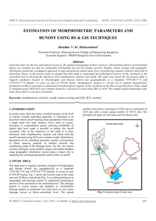
Fig. 2 Micro Watershed map of study area
3. DATA USED
The Survey of India (SOI) topomap nos. 57C /04, 57D/01,
48O/16, 48P/13 topomaps on 1:50000 scale. are used for
delineation of catchment, Micro-watersheds and drainage
map. IRS-1D LISS III 15th December, 2001 and March 15th,
2001 are used for updating drainage map and preparation of
thematic maps. Daily rainfall data for runoff estimation on
daily basis is considered.
4. MORPHOMETRIC ANALYSIS:
Morphometric analysis provides quantitative description of the
basin geometry to understand initial slope or inequalities in the
rock hardness, structural controls, geological and geomorphic
history of drainage basin [Strahler, 1964]. One of the
advantages of morphometric analysis is that many of the
watershed parameters derived are in the form of ratios,
dimensionless numbers, thus providing an effective
comparison irrespective of scale [Krishnamurthy et al., 1996].
The morphometric analysis is the measurement of linear
aspect, areal and relief aspects of drainage basin. The concept
of stream ordering has been outlined by [Horton 1932] and
later amended by [Strahler 1964] to decrease the subjectivity
of drainage analysis. The highest order assigned is 6th order
and hence designated as sixth order catchment. Fig. 3 shows
the stream order map. Moprhomteric characteristics and
parameters estimated are tabulated in Table 1 and 2
respectively.
Fig. 3 Stream order map](data:image/gif;base64,R0lGODlhAQABAIAAAAAAAP///yH5BAEAAAAALAAAAAABAAEAAAIBRAA7)
Recommandé
Recommandé
Contenu connexe
Tendances
Tendances (17)
Similaire à Estimation of morphometric parameters and runoff using rs & gis techniques
Similaire à Estimation of morphometric parameters and runoff using rs & gis techniques (20)
Plus de eSAT Journals
Plus de eSAT Journals (20)
Dernier
Dernier (20)
Estimation of morphometric parameters and runoff using rs & gis techniques
- 1. IJRET: International Journal of Research in Engineering and Technology eISSN: 2319-1163 | pISSN: 2321-7308 __________________________________________________________________________________________ IC-RICE Conference Issue | Nov-2013, Available @ http://www.ijret.org 449 ESTIMATION OF MORPHOMETRIC PARAMETERS AND RUNOFF USING RS & GIS TECHNIQUES Shrudha. V. K¹, Hafeezunnisa² 1 Assistant Professor, Rajarajeshwari College of Engineering Bangalore 2 Assistant Engineer, WRDO Bangalore Govt of Karnataka Abstract Land and water are the two vital natural resources, the optimal management of these resources with minimum adverse environmental impact are essential not only for sustainable development but also for human survival. Satellite remote sensing with geographic information system has a pragmatic approach to map and generate spatial input layers of predicting response behavior and yield of watershed. Hence, in the present study an attempt has been made to understand the hydrological process of the catchment at the watershed level by drawing the inferences from moprhometric analysis and runoff. The study area chosen for the present study is Yagachi catchment situated in Chickamaglur and Hassan district lies geographically at a longitude 75⁰52’08.77”E and 13⁰10’50.77”N latitude. It covers an area of 559.493 Sq.km. Morphometric analysis is carried out to estimate morphometric parameters at Micro-watershed to understand the hydrological response of the catchment at the Micro-watershed level. Daily runoff is estimated using USDA SCS curve number model for a period of 10 years from 2001 to 2010. The rainfall runoff relationship of the study shows there is a positive correlation. Keywords: morphometric analysis, runoff, remote sensing and GIS, SCS - method ----------------------------------------------------------------------***----------------------------------------------------------------------- 1. INTRODUCTION In recent years, there has been a marked increase in the level of interest towards watershed approach. A watershed is an area from which runoff resulting from precipitation flows past a single point into large streams, rivers, lakes or oceans. Advances in computational power, growing availability of spatial data have made it possible to predict the runoff accurately. One of the objectives of the study is to draw inferences from morphometric analysis and check with the runoff estimated using SCS curve number model. Quantitative description of the catchment geometry requires measurement of linear features, gradient of channel network and contributing slope of the drainage basin. For this, the remote sensing techniques using satellite images and digital database using geographic information system plays a major role in analyzing the catchment parameters and its effect on runoff. 2. STUDY AREA: The study area is Yagachi catchment situated in Chickamaglur and Hassan district lies geographically at a longitude 75⁰52’08.77”E and 13⁰10’50.77”N latitude. It covers an area of 559.493 Sq.km. Fig. 1 shows the location map of the study area and 20 Micro-watersheds (Fig. 2) are delineated based on topography and drainage pattern to understand hydrological process of the catchment at the watershed level. The drainage pattern is coarse texture and dendritic to sub-dendritic drainage pattern at catchment level and coarse to very coarse drainage texture at Micro-watersheds level. The annual rainfall varies from a maximum of 2301 mm to a minimum of 1233 mm with a mean annual rainfall of 1921.5 mm. The principal soil types are red loamy and red clayey soils Fig. 1 Location map of study area
- 2. IJRET: International Journal of Research in Engineering and Technology eISSN: 2319-1163 | pISSN: 2321-7308 __________________________________________________________________________________________ IC-RICE Conference Issue | Nov-2013, Available @ http://www.ijret.org 450 Fig. 2 Micro Watershed map of study area 3. DATA USED The Survey of India (SOI) topomap nos. 57C /04, 57D/01, 48O/16, 48P/13 topomaps on 1:50000 scale. are used for delineation of catchment, Micro-watersheds and drainage map. IRS-1D LISS III 15th December, 2001 and March 15th, 2001 are used for updating drainage map and preparation of thematic maps. Daily rainfall data for runoff estimation on daily basis is considered. 4. MORPHOMETRIC ANALYSIS: Morphometric analysis provides quantitative description of the basin geometry to understand initial slope or inequalities in the rock hardness, structural controls, geological and geomorphic history of drainage basin [Strahler, 1964]. One of the advantages of morphometric analysis is that many of the watershed parameters derived are in the form of ratios, dimensionless numbers, thus providing an effective comparison irrespective of scale [Krishnamurthy et al., 1996]. The morphometric analysis is the measurement of linear aspect, areal and relief aspects of drainage basin. The concept of stream ordering has been outlined by [Horton 1932] and later amended by [Strahler 1964] to decrease the subjectivity of drainage analysis. The highest order assigned is 6th order and hence designated as sixth order catchment. Fig. 3 shows the stream order map. Moprhomteric characteristics and parameters estimated are tabulated in Table 1 and 2 respectively. Fig. 3 Stream order map
- 3. IJRET: International Journal of Research in Engineering and Technology eISSN: 2319-1163 | pISSN: 2321-7308 __________________________________________________________________________________________ IC-RICE Conference Issue | Nov-2013, Available @ http://www.ijret.org 451 Table.1 Morphometric Characteristic of Yagachi catchment Table.2 Morphometric Parameters of Yagachi Catchment Different Morphometric Parameter of Yagachi Catchment Sl no Watershed parameters Units Values 1 Watershed area Km² 559.49 2 Perimeter of Watershed Km 114.99 3 Watershed highest order No 6 4 Maximum length of Watershed Km 31.83 5 Maximum width of Watershed Km 28.4 6 Form factor 0.55 7 Shape factor 1.81 8 Cumulative stream segment Km 1552 9 Cumulative stream length Km 683.68 10 Stream frequency No/Km² 2.774 11 Drainage density Km/Km² 1.222 12 Constant of Channel maintenance Km²/Km 0.818 13 Length of Overland flow Km 0.67 14 Bifurcation ratio 0.999 15 Stream length ratio 2.277 16 Circularity ratio 0.531 17 Elongation ratio 0.593 18 Compactness coefficient 1.372 19 Watershed relief ratio 0.024 20 Relative relief ratio 0.628 21 Ruggedness number 0.0009 Stream order No of segments (Nu) Total Stream length " L " (Km) Bifurcation ratio (Rb) Mean length Lu (Km) Cumulative length (Km) Cumulative No of Segments Stream Length Ratio (RL= Lu/(Lu- 1)) Drainage density 1 1301 551.85 6.706 0.424 551.85 1301 - 0.986 2 194 100.9 4.512 0.52 652.75 1495 1.226 3 43 19.17 4.3 0.446 671.92 1538 0.857 4 10 6.308 3.333 0.631 678.23 1548 1.415 5 3 1.879 3 0.626 680.11 1551 0.993 6 1 3.573 - 3.573 683.68 1552 5.705
- 4. IJRET: International Journal of Research in Engineering and Technology eISSN: 2319-1163 | pISSN: 2321-7308 __________________________________________________________________________________________ IC-RICE Conference Issue | Nov-2013, Available @ http://www.ijret.org 452 5. RUNOFF ESTIMATION: Reliable prediction of quantity and rate of runoff from land surface into streams and rivers is difficult and time consuming. Conventional models for prediction of river discharge require considerable hydrological and metrological data. Collection of these data is expensive, time consuming and a difficult process. Remote sensing technology has augmented the conventional methods to a great extent in rainfall-runoff studies. The curve number method (Soil Conservation Services, SCS, 1972) also known as the hydrologic soil cover complex method is a versatile and widely used procedure for runoff estimation for ungauged watersheds. McCuen (1982);Stube and Johnston (1990); Ramaprasad et al. (1993); Ponce and Hawkins (1996) Nageshwar Rao (2010) have demonstrated the use of SCS curve number model for runoff estimation. This method include several important properties of watershed namely soil permeability, land use and antecedent soil moisture condition. The SCS curve number method is based on the water balance equation and developed on two fundamental hypothesis. The first Hypothesis is expressed as; Q/(P-Ia)=F/S (1) where Q is the runoff, P is the rainfall and F is the actual infiltration and it is the difference between the potential and accumulated runoff. Ia is the initial abstraction, which represent all the losses before the runoff begins. S is the potential infiltration after the runoff begins (S>F). The second hypothesis is expressed as ; F= (P-Ia)-Q (2) Substituting F in eq(1) and rewriting we get; Q= (P-Ia)2/ (P-Ia)+S (3) Where IA=0.2S (4) S is spatially distributed variable defined As S = (25400/CN)-254 (5) Curve Number Index (CN) is a relative measure of retention of water by a given soil vegetation complex and takes on values from 0 to 100. It is a combination of a hydrologic soil group and antecedent moisture conditions. The Curve Number values for AMC-I and AMC-III are obtained from AMC-II [Ven Te Chow, 1982] by the method of conservation. The empirical equations used for estimation of CN1 and CN3 are as follows CN1=CN2/ (2.281-0.0128CN2) (6) CN3=CN2/ (0.427+0.00573CN2) (7) The curve number are assigned on by polygon wise by overlaying the land use/land cover map and hydrological map Fig. 4 Land use/Land Cover Map Fig. 5 Hydrological Soil Group map
- 5. IJRET: International Journal of Research in Engineering and Technology eISSN: 2319-1163 | pISSN: 2321-7308 __________________________________________________________________________________________ IC-RICE Conference Issue | Nov-2013, Available @ http://www.ijret.org 453 Fig. 6 Curve Number map Fig. 6 shows the curve number map of the catchment area. The daily runoff on watershed wise is estimated for a period of 10 years from 2001 to 2010 by concentrating all the three AMC conditions with daily rainfall data. 6. RESULTS & DISCUSSION: The term bifurcation ratio (Rb) is used to express the ratio of number of streams of any given order to the ratio of streams in the next higher order. It is observed that, the bifurcation ratio is less than 5 indicating that the catchment is structurally controlled or the structural disturbance is less. But, when individual Micro-watersheds are analyzed higher bifurcation ratio is noted in most of the Micro-watersheds which indicates structural disturbance and head ward erosion. The bifurcation ratio of all micro-watersheds indicates normal category. The presence of low drainage density suggests that it has highly permeable sub-soil and moderate to coarse drainage texture. The value of stream frequency for all the Micro-watershed varies from 1.73 to 6.34. It is noted that the drainage density values of all the micro watersheds exhibit positive correlation with the stream frequency suggesting that there is an increase in stream population with respect to increasing drainage density. The rainfall runoff relationship for the Yagachi catchment is shown in fig 7. It is depicted that positive correlation occurs between rainfall and runoff in all the 20 micro-watersheds. The regression coefficient values for the micro-watersheds lie between 0.602 to 0.866. The maximum weighted rainfall and runoff for the catchment was 1530mm and 184mm and minimum rainfall and runoff were 779 mm and 42mm respectively during 10 years period. It is observed that during the year 2009 maximum rainfall and runoff of 2301mm and 753mm respectively have occurred in Micro-watershed 1. It is also observed that during the year 2006 in Micro-watershed 12 minimum runoff of 15 mm has occurred. It is depicted that positive correlation occurs between rainfall and runoff in all the 20 Micro-watersheds. Fig. 7 Rainfall- runoff relationship of Yagachi Catchment The model was repeated to estimate the runoff and also to find the impact of change in trend of lulc from year 2001 to 2010 on the runoff using the same rain guage data and the results observed were tabulated in Table. 3. Table.3 Impact on Runoff due to Change in LULC Comparative table showing the impact on runoff due to change in LULC 2001 2010 Year Rainfall Runoff Rainfall Runoff 2001 1055.34 56.53 1055.34 40.39 2002 915.00 42.18 915.13 32.63 2003 778.52 54.27 778.52 41.03 2004 1183.90 104.34 1183.90 75.55 2005 1529.70 118.80 1529.70 80.15 2006 1206.32 57.10 1206.32 37.13 2007 1463.89 183.93 1463.89 140.43 2008 1448.61 120.44 1448.61 85.16 2009 1397.11 101.28 1397.11 69.91 2010 1482.96 88.13 1482.96 61.88
- 6. IJRET: International Journal of Research in Engineering and Technology eISSN: 2319-1163 | pISSN: 2321-7308 __________________________________________________________________________________________ IC-RICE Conference Issue | Nov-2013, Available @ http://www.ijret.org 454 Table.4 Change in the trend of LULC from 2001 to 2010 For Yagachi Catchment CONCLUSIONS The catchment is well distributed with tanks which are basically fed by rain water and the perennial streams which find its flow due to regenerated irrigation, subsurface flow and due to presences of Western Ghats from where river Hemavathi originates. The study has demonstrated that, remote sensing and GIS has advantages in estimating runoff from large and ungauged catchments. The drainage density obtained from the study shows that the catchment is a coarse textured catchment. Curve number estimation using remotely sensed data has been shown to be more cost effective than conventional procedure. The study will serves as an input for the management of natural resources available within the watershed. The maximum and minimum runoff estimated for individual micro watershed during the period 2001 to 2010 is 2310 mm and 15mm respectively. The observed inflow is more than the estimated runoff, this is mainly due to continuous irrigation, seepage from the agricultural land and lateral flow causing in the catchment area. REFERENCES [1]. Horton, R. E (1932) Drainage basin characteristics, Transaction of the American Geophysical Unions, 13, pp. 350- 361. [2]. McCuen, R. H (1982), A Guide to Hydrologic Analysis using SCS Methods, Prentice Hall Inc., New Jersey. [3]. Nageshwar Rao. K, Swarna Latha. K ., Arunkumar. P and Harikumar, M (2007) Marphometric Anlysis of Geostani River Basin in Andhra Pradesh State, India usning Spatral Information Technology, Indian Journal of Geomatics and Geosciences, Vol-1, No.1, pp. 179-187. Abstract of LULC for Yagachi catchment SI No LULC-Level-3 Area(2001) Area(2010) 1 Agricultural Plantation 171.718 164.822 2 Barren Rocky / Stony Waste / Sheet Rock Area 2.185 0.164 3 Degraded Forest 0.832 4.671 4 Dense Grass land / Grazing land 1.644 12.953 5 Fallow land 3.978 8.92 6 Forest Plantations 1.945 0.161 7 Habitation with Vegetation 5.436 40.007 8 Kharif + Rabi (Double Crop) 48.822 38.953 9 Kharif crop 253.14 192.87 10 Lake / Tanks 12.41 2.745 11 Reservoir/Rivers/streams 2.016 0 12 Land with scrub 12.465 10.987 13 Mining / Industrial Wasteland 0.074 0 14 Mixed Vegetation 4.01 5.89 15 Moist & Dry Deciduous Dense Forest 4.712 3.921 16 Moist & Dry Deciduous Open Forest 1.243 6.723 17 Town / Cities/Villages 20.58 6.328 18 Tree Groves 12.282 37.588 19 Tanks without water 0 21.791 TOTAL 559.493 559.494
- 7. IJRET: International Journal of Research in Engineering and Technology eISSN: 2319-1163 | pISSN: 2321-7308 __________________________________________________________________________________________ IC-RICE Conference Issue | Nov-2013, Available @ http://www.ijret.org 455 [4]. Ponce, M Victor and Hawkins H Richard (1996) Runoff Curve Number; Has it Reached Maturity Journal of Hydraulic Engineering, ASCE (1), pp. 11- 19. [5]. Rama Prasad, Sridharan, K., and Vedula, S (1993), Runoff Estimation for small ungauged catchments, Report Prepared for Chief Engineer (Minor Irrigation), Govt- of Karnataka, India. [6] Ravikumar, A. S, (2001), Water Balance Components from Field Studies using Remote Sensing and Geographical Information System, Ph. D Thesis, Indian Institute of Science, Bangalore [7].Soil Conservation Services, (1972), National Engineering Handbook, Hydrology, Section 4, Chapter 4 to 10. [8].Strahler, A. N (1964) Quantitative Geomorphology of Drainage basin and channel Network. Hand book of Hydrology edited by Ven Te Chow, McGraw Hell section 4- 11. [9].Stube, M. M and Johnston, D. M (1990) Runoff Volume Estimation Using SCS Techniques, Water Resources. Bull., 26 (4), pp. 611-620. [10].Ven Te Chow (1982) Handbook of Applied Hydrology, McGraw Hill Book Company.