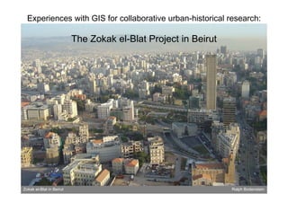
Experience with GIS for collaborative historical urban research: The Zokak el Blat project in Beirut
•
3 j'aime•3,240 vues

This presentation was given by Ralph Bodenstein (German Archaeological Institute, Cairo, Egypt) during the workshop organized in the framework of the Cost Action IS0904 "European Architecture Beyond Europe" (INHA, Paris, France, 27-28th January 2014). Programme : http://www.architecturebeyond.eu/workshop-gis-data-visualisation-and-open-community-paris-27-28-january-2014/

Recommandé
Contenu connexe
Tendances
Tendances (20)
En vedette
En vedette (12)
Plus de Lesticetlart Invisu
Plus de Lesticetlart Invisu (20)
Dernier
Dernier (20)
Experience with GIS for collaborative historical urban research: The Zokak el Blat project in Beirut
- 1. Experiences with GIS for collaborative urban-historical research: The Zokak el-Blat Project in Beirut Zokak el-Blat in Beirut Ralph Bodenstein
- 2. Zokak el-Blat Zokak el-Blat in Beirut Ralph Bodenstein
- 3. Zokak el-Blat Zokak el-Blat in Beirut Ralph Bodenstein
- 4. DFG-funded research project „Zokak el-Blat: History, structure, and transformation of a pericentral quarter of Beirut” Interdisciplinary Field-research based DFG funding 2001-2003 Actual start 1997 – end 2004 Location: Orient-Institute Beirut (OIB) Project supervisors: Hans Gebhardt Dorothée Sack Research team: Anne Mollenhauer – architectural history Ralph Bodenstein – urban & architectural history Jens Hanssen – history Oliver Kögler – urban geography Andreas Fritz – urban geography Bernhard Hillenkamp – political sciences Friederike Stolleis – social anthropology Zokak el-Blat in Beirut Ralph Bodenstein
- 5. Zokak el-Blat in Beirut History, structure, and transformation of a pericentral quarter Ralph Bodenstein
- 6. Zokak el-Blat in Beirut History, structure, and transformation of a pericentral quarter Ralph Bodenstein
- 7. Zokak el-Blat in Beirut Ralph Bodenstein
- 8. The GIS of the Zokak el-Blat project Function: Platform for • central data deposit • access to, exchange of, and comparison of data among team members • spatialisation and visualisation of collected data • to help analysis and interpretation of data • production of maps for presentation and publication • Programme: ArcView GIS 3.2 • • GIS was introduced with delay at an advanced stage of the project Not online, but based on desktop computers in the project office, with additional copies on laptops (data updates required!) Zokak el-Blat in Beirut Ralph Bodenstein
- 9. Building and feeding our GIS: • Starting out from a up-to-date basic map (remember? G ( b ? Google E th did ‘t exist yet!) l Earth didn‘t i t t!) Zokak el-Blat in Beirut Ralph Bodenstein
- 10. Zokak el-Blat in Beirut Ralph Bodenstein
- 11. Building and feeding our GIS: • Starting out from an up-to-date basic map • Addi cadastral maps (1 2000 of 1964 1 500 series Adding d t l (1:2000 f 1964, 1:500 i of 1930s and after) Zokak el-Blat in Beirut Ralph Bodenstein
- 12. Zokak el-Blat in Beirut Ralph Bodenstein
- 13. Zokak el-Blat in Beirut Ralph Bodenstein
- 14. Building and feeding our GIS: • Starting out from an up-to-date basic map • Addi cadastral maps (1 2000 of 1964 1 500 series Adding d t l (1:2000 f 1964, 1:500 i of 1930s and after) • Adding existing survey studies Zokak el-Blat in Beirut Ralph Bodenstein
- 15. Zokak el-Blat in Beirut Ralph Bodenstein
- 16. Building and feeding our GIS: • Starting out from an up-to-date basic map • Addi cadastral maps (1 2000 of 1964 1 500 series Adding d t l (1:2000 f 1964, 1:500 i of 1930s and after) • Adding existing survey studies • Adding own urban survey data (e.g. building heights, building age building types state of preservation age, types, preservation, functions and use, inhabitants…) Zokak el-Blat in Beirut Ralph Bodenstein
- 17. Zokak el-Blat in Beirut Ralph Bodenstein
- 18. Building and feeding our GIS: • Starting out from an up-to-date basic map • Addi cadastral maps (1 2000 of 1964 1 500 series Adding d t l (1:2000 f 1964, 1:500 i of 1930s and after) • Adding existing survey studies • Adding own urban survey data (e.g. building heights, building age building types state of preservation age, types, preservation, functions and use, inhabitants…) • Adding HISTORICAL LAYERS using historical aerial photos and maps Zokak el-Blat in Beirut Ralph Bodenstein
- 19. Zokak el-Blat in Beirut Ralph Bodenstein
- 20. Zokak el-Blat in Beirut Ralph Bodenstein
- 21. Street shapes Building shapes Layers f L for: 1920, 1945, 1964, 1977, 1991, 2003 Zokak el-Blat in Beirut Ralph Bodenstein
- 22. Tracing & visualising processes of urban change Zokak el-Blat in Beirut Ralph Bodenstein
- 23. Zokak el-Blat in Beirut Ralph Bodenstein
- 24. 1964 1977 Zokak el-Blat in Beirut Ralph Bodenstein
- 25. Zokak el-Blat in Beirut Ralph Bodenstein
- 26. Zokak el-Blat in Beirut Ralph Bodenstein
- 27. 1920 Zokak el-Blat in Beirut Ralph Bodenstein
- 28. 1945 Zokak el-Blat in Beirut Ralph Bodenstein
- 29. 1964 Zokak el-Blat in Beirut Ralph Bodenstein
- 30. 1977 Zokak el-Blat in Beirut Ralph Bodenstein
- 31. 1991 Zokak el-Blat in Beirut Ralph Bodenstein
- 32. 2003 Zokak el-Blat in Beirut Ralph Bodenstein
- 33. Tackling tables and challenges Zokak el-Blat in Beirut Ralph Bodenstein
- 34. Zokak el-Blat in Beirut Ralph Bodenstein
- 35. Zokak el-Blat in Beirut Ralph Bodenstein
- 36. Zokak el-Blat in Beirut Ralph Bodenstein
- 37. Zokak el-Blat in Beirut Ralph Bodenstein
- 38. Word files html fil ht l files image files Zokak el-Blat in Beirut Ralph Bodenstein
- 39. Zokak el-Blat in Beirut Ralph Bodenstein
- 40. What to do with with… - Multiple data per polygon shape? - Non-spatial or „amorphous“ information? - sensitive information? Zokak el-Blat in Beirut Ralph Bodenstein
- 41. Zokak el-Blat in Beirut Ralph Bodenstein
- 42. Zokak el-Blat in Beirut Ralph Bodenstein