Introduction to Surveying under ECE
•
9 j'aime•1,010 vues

A brief introduction of surveying under the coarse of civil engineering. Covers various aspects of surveying.

Recommandé
Contenu connexe
Tendances
Tendances (20)
En vedette
En vedette (20)
Similaire à Introduction to Surveying under ECE
Similaire à Introduction to Surveying under ECE (20)
Dernier
Dernier (20)
Introduction to Surveying under ECE
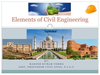
- 1. B Y : R A K E S H K U M A R V E R M A A S S T . P R O F E S S O R C I V I L E N G G . P . I . E . T . Elements of Civil Engineering Amer Fort, Rajasthan Agra Fort TajMahal
- 2. Civil Engineering One of the oldest of the engineering professions Includes the designing, planning, construction, and maintenance of the infrastructure Works include roads, bridges, buildings, dams, canals, water supply Concerned with determining the right design for these structures and looking after the construction process Egyptian pyramids and Roman road systems are based on civil engineering principles
- 5. Design Planning Construct Field Surveying Planning and Drawing Estimation & Implementation Maintenance
- 9. Civil Engg. in Daily routine Water Treatment Plant All have been designed and constructed by civil engineers Morning Shower Water Supply System Network of Roads Structural Bridges Tall Buildings
- 10. Importance and Applications of Civil Engineering building good quality transportation systems like highways, airports, rail lines, sea ports, etc fire control systems and installing quick fire exit points in the buildings minimizing the loss of life during fire accidents purify the contaminated air, water and soil
- 11. Continue…….. Other principal works in which surveying is primarily utilised are 1. to fix the national and state boundaries; 2. to chart coastlines, navigable streams and lakes; 3. to establish control points; 4. to execute hydrographic and oceanographic charting and mapping; and 5. to prepare topographic map of land surface of the earth.
- 13. Diamond Crossing Indian Railway Delhi
- 14. Palais Royale Mumbai China’s Dawang Mountain Resort ITC Maurya Hotel in New Delhi Signature tower, Abu Dhabi
- 16. Surveying American Congress on Surveying and Mapping (ACSM) defines as; Surveying is the science and art of making all essential measurements to determine the relative position of points or physical and cultural details above, on, or beneath the surface of the Earth, and to depict them in a usable form, or to establish the position of points or details. This is being carried out by finding the spatial location (relative / absolute) of points on or near the surface of the earth.
- 17. Land Surveying The science of determining the relative positions of points on the Earth’s surface Primary Division of Survey( based on accuracy) Geodetic Surveys Plane Surveys
- 20. Takes into account the true size, shape, and gravity fields of the Earth The geoid is the equipotential surface of the Earth’s gravity field which best fits global mean sea level Provides significant precision Establishes highly accurate control networks Geodetic Survey
- 21. Surveying aims to measure the Horizontal Distance between points. to measure the Vertical elevation between points. to find out the Relative direction of lines by measuring horizontal angles with reference to any arbitrary direction and to find out Absolute direction by measuring horizontal angles with reference to a fixed direction.
- 22. Plane Survey Assumes the Earth’s surface to be a plane (flat) More common than geodetic surveys Precise enough for small- scale surveys in a limited area, such as a construction site Used to determine legal boundaries, construction surveys, and small-area topographic or control surveys
- 23. Plane Surveying When radius of curvature of the earth is not taken into account. Small area and small distances are covered Degree of accuracy is comparatively low. American survey put 250 km2 for treating survey as Plane, but controlling factor should be degree of precision rather than extent of area.
- 24. Based upon Nature of field Based upon Method Employed Land Survey Marine Survey Astronomical Survey Triangulation Traversing Types of Surveying
- 25. Based upon Object of Survey Based upon Instrument Used Geological Survey(Object is to survey different strata in the earth crust) Mine Survey (Mineral wealth such as coal, gold) Military Survey(Points of strategic importance) Surveying by Total Station Chain Survey Theodolite Survey Compass Survey Plane Tabling Photographic and Aerial Surveys Types of Surveying
- 26. Topographical Survey Cadastral Survey Determine natural features of a country such as hills, valleys, lakes woods etc. and also arterial features such as roads, buildings, canals, towns etc. Details such boundaries of houses, town, fields and other properties pathways are determined. 1. City Survey 2. Engineering Survey Land Survey
- 27. Engineering Survey Engineering Survey can be further divided into: Reconnaissance (To determine the feasibility and rough cost of the scheme) Preliminary Survey (For collecting more precise data) Location Survey(For setting out the work on the ground)
- 28. Geodetic or Trigonometrical Surveying When the radius of curvature of earth is taken in to account. Large area and large distances are covered. Object of geodetic survey is to determine precise positions on the surface of earth. Refined Instruments and Methods are used. Conducted by Government agencies.
- 29. No. Plain Surveying Geodetic Surveying 1 The earth surface is considered as plain Surface. The earth surface is considered as Curved Surface. 2. The Curvature of the earth is ignored The curvature of earth is taken into account. 3 Line joining any two stations is considered to be straight The line joining any two stations is considered as spherical. 4. The triangle formed by any three points is considered as plain The Triangle formed by any three points is considered as spherical. 5. The angles of triangle are considered as plain angles. The angles of the triangle are considered as spherical angles. 6. Carried out for a small area < 250 km2 Carried out for a small area > 250 km2
- 30. ‘Earth’ As considered spherical in shape Plumb Line Geoid, Actual surface of earth Geodetic survey line, equal elevation from center of earth Horizontal survey line, equal elevationHorizontal plane Rod Rod Geodetic vs. Plane Survey
- 31. Types of Surveys Control Survey Topographic Survey Property Survey Site Survey Construction Survey
- 32. Control Survey Establish precise horizontal and vertical positions of points that serve as a reference for other surveys
- 43. Topographic Survey Gathers data on the location of natural and man-made features, contours, and ground elevation to create a topographic map
- 44. Property Survey (or Boundary Survey) Establishes property lines for a lot Used to create a plat
- 45. Site Survey (Plot Survey or Lot Survey) Combination of a property survey and topographic survey May be required to receive a construction permit
- 46. Construction Survey Locates points and elevations that can be used to establish correct locations and elevations for engineering and architectural projects
- 47. National Spatial Reference System (NSRS) Common set of reference points for all surveys Horizontal Datum = Collection of points of known latitude and longitude Vertical Datum = Collection of points of known elevation Benchmark (BM) = Permanent mark that establishes a point of known elevation
- 48. Optical Equipment A theodolite measures vertical and horizontal angles A total station is an electronic/optical surveying instrument
- 49. Optical Equipment Automatic (Auto) Level Commonly used on building sites Internal compensator can automatically level the instrument Measures difference in elevation between the line of sight and a point
- 50. Auto Level Bulls Eye Level Telescope Leveling Screws Horizontal Angle Rotation Ring Eyepiece Horizontal Tangent Knob Sight Diopter Adjustment Ring Mirror Kennedy
- 51. Professional Tape Measure Field Book Other Equipment Tripod Leveling Rod
- 52. Reading the Rod Stadia hairs Horizontal crosshair Vertical crosshair View through the telescope
- 53. Reading the Rod Upper Stadia Reading = 5.30 m Rod Reading = 5.25 m Lower Stadia Reading = 5.20 m
- 54. Stadia Readings • Estimate distance between rod and instrument • Rod intercept is the difference between stadia readings • Estimated distance • Stadia multiplier typically = 100 – Indicated on inside of instrument case or in Instructional Manual
- 55. Example Upper Stadia Reading = 5.30 ft Lower Stadia Reading = 5.20 ft Rod Intercept = 0.10 ft
- 56. Differential Leveling The establishment of differences in elevation between two or more points with respect to a datum Earth Surface Datum line or plane BM BS FS Staff Staff Instrument Point of unknown elevation
- 57. GPS Technology Global Positioning System A global navigation satellite system Developed by the U.S. Department of Defense A constellation of satellites that broadcast radio signals Receivers intercept several satellite signals in order to determine precise location
- 58. GPS